CIMMS Forecast and Warning Improvements - Don Burgess, CIMMS Partners from CIMMS Partners from NSSL Partners from ROC

Page created by Jimmie Paul
 
CONTINUE READING
CIMMS Forecast and Warning Improvements - Don Burgess, CIMMS Partners from CIMMS Partners from NSSL Partners from ROC
CIMMS Forecast and Warning
     Improvements

       Don Burgess, CIMMS
         Partners from CIMMS
         Partners from NSSL
         Partners from ROC

      CIMMS 40th Anniversary Celebration   November 15, 2018
CIMMS Forecast and Warning Improvements - Don Burgess, CIMMS Partners from CIMMS Partners from NSSL Partners from ROC
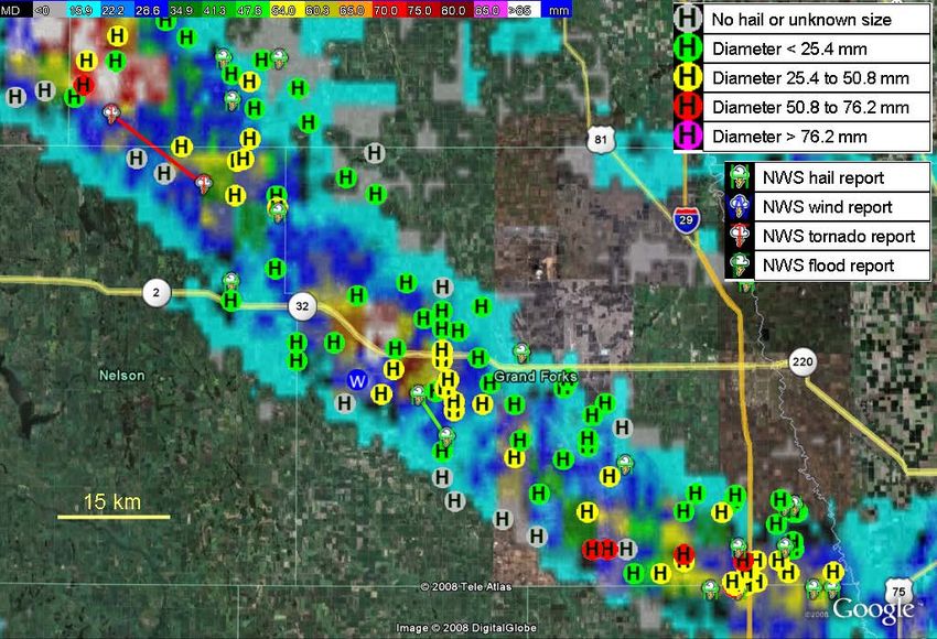
Early CIMMS (1980ish): Basics Being Developed

• Experimental Doppler Radar (NRO, CIM); Very Little Forecaster Radar Understanding: DOPLIGHT (1984-1987)
• Scientific Storm Intercept for Verification of Radar Signatures and Understanding Storm Structures
• Basic Understanding of Mesoscale and Near Storm Environments Were Aided by Field Programs

                                   CIMMS 40th Anniversary Celebration   November 15, 2018
CIMMS Forecast and Warning Improvements - Don Burgess, CIMMS Partners from CIMMS Partners from NSSL Partners from ROC
Initial WSR-88D Severe Storm Detection & Algorithms

   KTLX-E Reflectivity & SCIT, April 26, 1991        KTLX-E Velocity & MESO, April 26, 1991              KTLX-E VWP, April 26, 1991

• Initial WSR-88D Display Products (not Level 2 resolution): Reflectivity, Velocity, Spectrum Width
• Initial Single-Radar WSR-88D Algorithms from CIMMS/NSSL/ROC:
           - SCIT: Storm Cell Identification & Tracking    - MESO: Mesocyclone Algorithm
           - HA: Hail Algorithm                           - TVS: Tornadic Vortex Signature
           - VWP: VAD Wind Profile                         - VDA: Velocity Dealiasing Algorithm
                                                CIMMS 40th Anniversary Celebration   November 15, 2018
CIMMS Forecast and Warning Improvements - Don Burgess, CIMMS Partners from CIMMS Partners from NSSL Partners from ROC
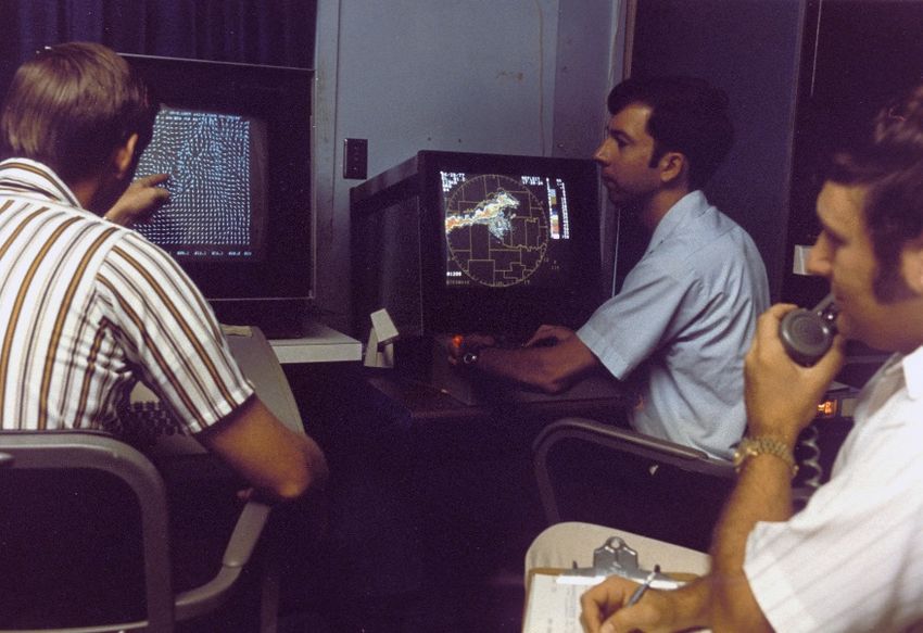
New/Improved Severe Storm Algorithms*: 1995-2018
•   MDA     Mesocyclone Detection Algorithm
•   TDA     Tornado Detection Algorithm
•   HAD      Hail Detection Algorithm
•   NSE      Near Storm Environment Algorithm
•   GFDA     Gust Front Detect Algorithm (FAA Only)
•   MBDA     Microburst Detection Algorithm (FAA only)
•   DDPDA   Damaging Downburst Prediction & Detection Algorithm
•   BWER    Bounded Weak Echo Region Algorithm                                              HSDA with Large Hail (LH) and Giant Hail (GH)
•   VDDA     Improved Velocity Dealiasing Algorithm
•   MPDA     Multi-PRF Dealiasing Algorithm
•   RS       Rapid Update - several algorithms using virtual volumes
•   HSDA     Hail Size Detection Algorithm
•   TDS     Tornado Debris Signature (Experimental)
•   NMDA     New MDA [Posters by B. Smith et al & T. Smith et al]
•   NTDA      New TDA [Posters by B. Smith et al & T. Smith et al]
•   NHDA     New HDA [Posters by B. Smith et al & T. Smith et al]

      Added to Baseline         Dual-Polarization       * Single-Radar Algorithms
      Not Added to Baseline     Experimental                                                TDS with Shading for Confidence Intervals

                                           CIMMS 40th Anniversary Celebration   November 15, 2018
CIMMS Forecast and Warning Improvements - Don Burgess, CIMMS Partners from CIMMS Partners from NSSL Partners from ROC
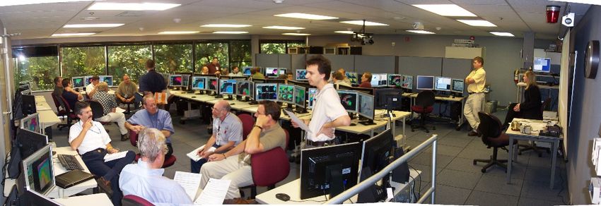
WSR-88D Data Display and Archive
• Data Display (Level 2 Data)                                                • Data Archive (Level 2 Data)
     •   WSR-88D Algorithm Testing & Display System (WATADS)                      • Collaborative Data Acquisition Field Test (CRAFT)
     •   Warning Decision Support System (WDSS)                                   • Radar Interface & Data Distribution (RIDDS)
     •   WDSS –Integrated Information (WDSSII)                                    • Integrated Radar Data Services (IRADS)
     •   System for Convective Analysis & Nowcasting (SCAN)
     •   Four-Dimensional Stormscale Investigator (FSI)

WDSS Image: May 3, 1999

                                FSI Image: Reflectivity Analysis; From             CRAFT Radars Sending Data to OU & NCDC in 2001; Project
                                NWS AWIPS2 System                                  Lasted until 2004
                                             CIMMS 40th Anniversary Celebration   November 15, 2018
CIMMS Forecast and Warning Improvements - Don Burgess, CIMMS Partners from CIMMS Partners from NSSL Partners from ROC
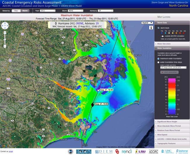
The Improvement in Tornado Warnings
                                  NWS Tornado Warning Skill Scores
                       1                                                                                  16
                                          NEXRAD Installation
                      0.9
                                                                                                          14

                      0.8
                                                                                                          12
                      0.7

                                                                                                          10

                                                                                                               Lead Time (min)
                      0.6
          POD & FAR

                      0.5                                                                                 8

                      0.4
                                                                                                          6

                      0.3
                                                                               Probability of Detection
                                                                                                          4
                      0.2                                                      False Alarm Ratio

                                                                               Lead Time (min)            2
                      0.1

                       0                                                                                  0

                                                     Year
Department of Commerce Gold Medal (NSSL; and CIMMS) “for achieving scientific and technical
breakthroughs leading to the continuous improvements in the national network of Doppler radars” (1997)
                                CIMMS 40th Anniversary Celebration   November 15, 2018
CIMMS Forecast and Warning Improvements - Don Burgess, CIMMS Partners from CIMMS Partners from NSSL Partners from ROC
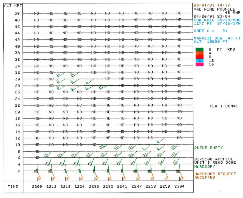
Multiple Radar/Multiple Sensor (MRMS) Severe Storm Applications
• Multi-Radar Multi-Sensor Applications Have Significant
    Advantages Over Single-Radar Applications
• First Called Quantitative Precipitation Estimation –
     Segregation Using Multiple Sensors (QPE-SUMMS)
• MRMS Combines QPE and Severe Storm Applications
    • Rotation Tracks (Shear Swaths)
    • Maximum Expected Size of Hail (MESH) Swaths
          • NSSL On Demand (Experimental)

                                                                                  MESH Swath Overlaid with Hail Reports from the Severe Hazards Analysis &
                                                                                  Verification Experiment (SHAVE). Note Correspondence between MESH Ouput
                                                                                  and SHAVE Reports. Note also the Low Number of Hail Reports Received by the
                                                                                  NWS Offices.

                                                                                                                [Poster by Ortega et al]
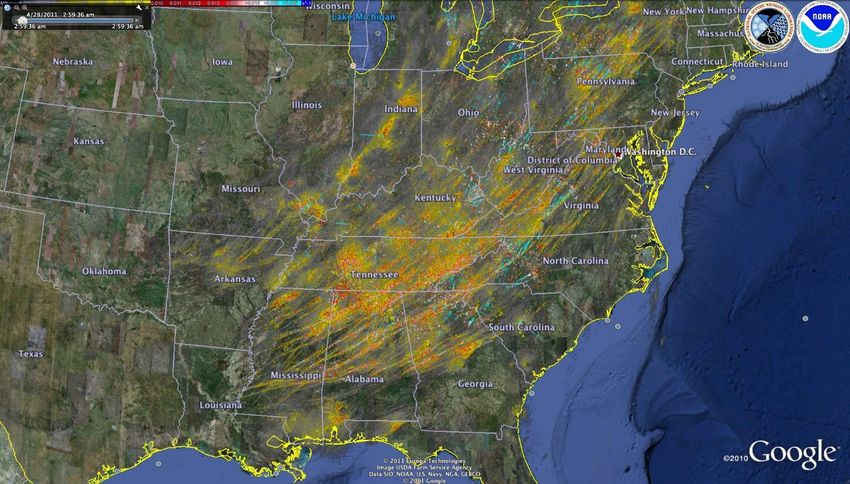
Rotation Tracks for April 27, 2011 Tornado Outbreak   CIMMS 40th Anniversary Celebration   November 15, 2018
CIMMS Forecast and Warning Improvements - Don Burgess, CIMMS Partners from CIMMS Partners from NSSL Partners from ROC
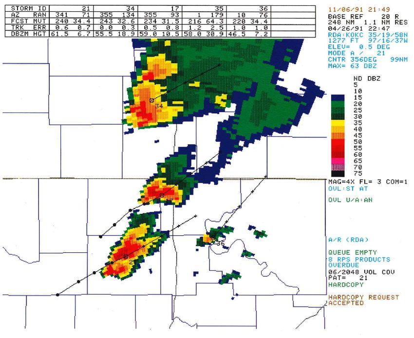
Advances in WSR-88D Radar Quantitative Precip Estimation (QPE)
                                                                                                                  Single Radar

                PPS (Fulton et al. 1998):                                                                              DPR (Giangrande & Ryzhkov 2008):
                single radar, single-pol                                                                               single radar, dual-pol
                single R(Z)/per radar; manually set                                                                    Hydrometeor classification
                                                                                                                       R(Z)/R(Z,ZDR)/R(KDP) synthetic

                          1991                            97            00                   04                              11             14                    2019
                                                                    CRAFT
                                                                    (Kelleher et al. 2007)                                      MRMS-Q3RAD (Zhang et al. 2016):
                                            Stage-II (Baldwin & Mitchell 1996):                                                 Multi-radar, single-pol
                                            multi-radar, single-pol                                                             dual-pol QC,
                                            Inverse distance weighted (IDW)                                                     multi R(Z),
                                            mosaicking                                                                          Precip classification
                                            4km, hourly                                                                         Bright band correction
                                                               Multi-Radar Multi-Sensor (MRMS)                                  Conditional IDW mosaicking
                                                                                                                                Canadian radar
                                                                                                                                1km, 2min
                                                               Z: reflectivity;     ZDR: differential reflectivity;
                                                                                                                                                        MRMS-Q3DP (Ryzhkov et al. 2014,
                                                               KDP: specific differential phase; A: specific
          DOC Silver Medal for                                                                                                                          Zhang et al. 2017):
                                                               attenuation
          Operational MRMS                                                                                                                              Multi-radar, dual-pol
          (2015)                                                                                                                                        R(A)/R(KDP) in rain and hail
                                                                                                                                                        Q3RAD in mixed and ice phase
                                                                    CIMMS 40th Anniversary Celebration                November 15, 2018                 Evaporation correction
Thanks to Jian Zhang; Poster by S Martinatis, et al
CIMMS Forecast and Warning Improvements - Don Burgess, CIMMS Partners from CIMMS Partners from NSSL Partners from ROC
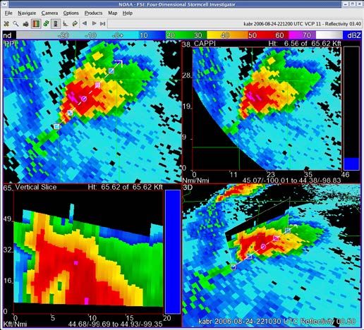
MRMS QPE and Flood Warnings
Flooded Locations and Simulated Hydrographs (FLASH) Project                                       Coastal and Inland Flooding Observation and
                                                                                                               Warning (CI-FLOW)
FLASH uses rainfall observations from MRMS and a hydrologic model to introduce a new
                                                                                                 CI-FLOW captures the complex interaction between MRMS
paradigm in flash flood prediction that produces outputs at 1-km 5-min resolution. It is now
                                                                                                rainfall, river flows, waves, tides and storm surge, and how
operational within the NWS.
                                                                                                they will impact ocean and river water levels

Ratio of QPE to Flash Flood Guidance            Maximum Unit Streamflow for an
for an event in North Texas on May              event in North Texas on May 29, 2015
29, 2015

                                                   CIMMS 40th Anniversary Celebration   November 15, 2018
CIMMS Forecast and Warning Improvements - Don Burgess, CIMMS Partners from CIMMS Partners from NSSL Partners from ROC
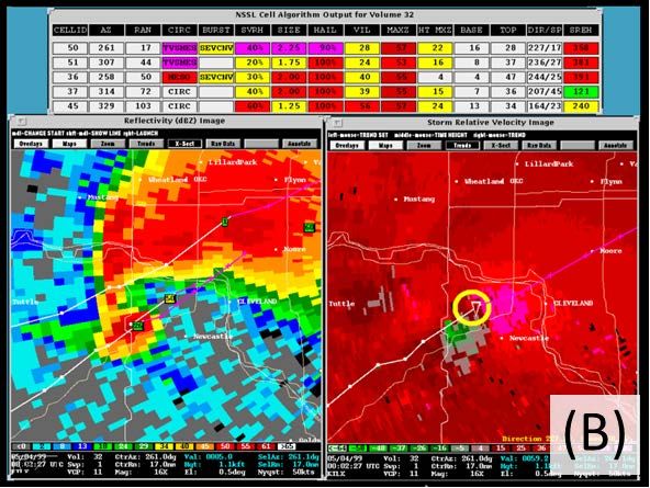
Forecast & Warning Improvement Success Tied to Training
• NWS Radar, Severe Storm and QPE/Flash Flood Training Done in Norman Since the 1990’s by: OTB, FIRSTT, WDTB, WDTD
• Tornado Warning Guidance, Distance Learning Courses, Workshops, Weather Event Simulator (WES)

                                                              Thanks to B. Grant & A. Wood     [Posters by A. Wood et al & D. Morris et al]

                                      CIMMS 40th Anniversary Celebration   November 15, 2018
Forecasts & Warnings of the Future: FACETs

               Thanks to Alan Gerard            [Posters by K. Calhoun et al & G. Stumpf et al]

           CIMMS 40th Anniversary Celebration     November 15, 2018
How FACETs Might Look for an April 27, 2011-Type Event

Thanks to Greg Stumpf
                        CIMMS 40th Anniversary Celebration   November 15, 2018
QUESTIONS?
You can also read