COAST TOUR WAITAKI WHITESTONE ASPIRING GEOPARK
←
→
Page content transcription
If your browser does not render page correctly, please read the page content below
www.whitestonegeopark.nz

    WAITAKI WHITESTONE
     ASPIRING GEOPARK

   COAST TOUR
www.waitakinz.com       Waitaki_NZ         WaitakiNZ   #   WaitakiNZ

   1 - 2 days             108 km                  Driving
                          one way

   This tour winds its way along the Pacific coast
                via State Highway 1.

   It's a driving tour that works well as a one or
     two day trip. The roads are suitable for all
                   kinds of vehicles.

   Some of the stops involve walking on uneven
                      paths.

   This Tour is also available to freely download
    on the Waitaki Whitestone Geopark App.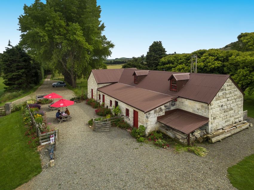
www.whitestonegeopark.nz

      WAITAKI WHITESTONE
       ASPIRING GEOPARK

     COAST TOUR
 www.waitakinz.com         Waitaki_NZ        WaitakiNZ    #     WaitakiNZ

Introduction
Welcome to the Waitaki Whitestone Geopark!

The Pacific coast is packed with charming towns, unique wildlife,
amazing geology and stunning, isolated sandy beaches. State
Highway 1 winds its way down the coast with many opportunities to
stop and enjoy the sights.

What is Tiaki – Care for New Zealand?

Tiaki means to care for people and place. New Zealand is precious,
and everyone who lives and travels here has a responsibility to look
after it.

The Tiaki Promise is a commitment to care for New Zealand, for
now and for future generations. By following the Tiaki Promise, you
are making a commitment to New Zealand:

Care for land, sea and nature, treading lightly and leaving no trace.

Travel safely, showing care and consideration for all Respect
culture, travelling with an open heart and mind.

For more information about the Tiaki Promise, visit
www.tiakinewzealand.com
Lindis       Omarama
                                                  Pass
                                                              8

                    www.whitestonegeopark.nz

                                   To Wanaka
    WAITAKI WHITESTONE            & Queenstown

     ASPIRING GEOPARK

   COAST TOUR
www.waitakinz.com       Waitaki_NZ         WaitakiNZ      #   WaitakiNZ

1. Ōamaru Limestone Dikes

2. Totara Estate

3. Brydone Monument

4. Clarks Mill

5. All Day Bay (Campbells Bay)

6. Bridge Point

7. Moeraki Boulders

8. Katiki Point

9. Matakaea Shag Point

10. Puketapu

11. Macraes Goldmine

12. What's next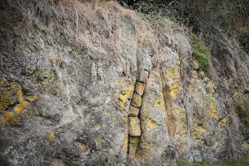
enmore
 Dam                WAITAKI WHITESTONE
                     ASPIRING GEOPARK
ta            mo COAST TOUR
         AvieLake Aviemore
                 re Dam
                                Lake
                               Waitaki                                                                To Timaru
                                  Waitaki                                                           & Christchurch
                                    Dam
              Kurow
                                            83

                                            Duntroon
                                                                                           Waitak
                                                                                                  i River

                                                   Island Cliff                                                     1
                                                     Ngapara
                                                         Windsor Enfield
               aotearoa                                                                  Weston
            new zealand                                                                                             Pukeuri
     To Alexandra
           TE WAI POUNAMU
             south
                                                                                                    1.    Oamaru
                                                                                          2.
             island                                                                                      Alps 2 Ocean
                                                                                    3.                   Finish
                                  waitaki                                           4.
                                oamaru

                                                                                     5.
                                                                                               Kakanui
                                                                Herbert              6.
                                            85                        1

                                                                                          Hampden

                                                          Dunback              7.
                          Macraes                                                              Moeraki
                                      11.                                                 8.

                                                         Palmerston       9.    Shag Point
                                                               10.

               State Highway                     To Dunedin
               Alps 2 Ocean Cycle Trail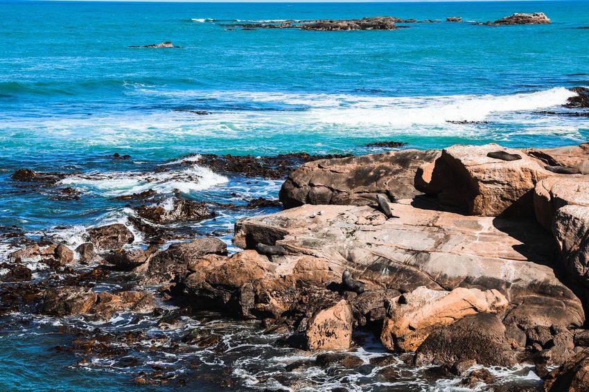
Back to itinerary

1. Ōamaru Limestone Dikes
         5 mins

         Stand at the north side of Chelmer Street, at the
         intersection with Chess St and opposite the Ōamaru
         Public Gardens

On the Ōamaru roadside you can see one of New Zealand’s
best examples of limestone dikes into tuff, or volcanic rock.
A dike is a large slab of rock that cuts through another type
of rock. In this case see this rare limestone dike formed by
infilling or injection of soft sediment material into fissures
that opened along the crest of the volcanic mound.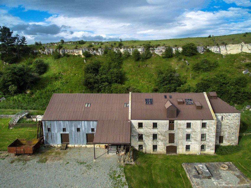
Back to itinerary

2. Totara Estate
        30 mins - 1 hour

        Totara Estate is about 8 kilometres south of Ōamaru
        on State Highway 1. Look for the road signs.

New Zealand is a country founded on agriculture, and Totara
Estate is a crucial part of that history. This historic farm
(originally 15,000 acres) was the birthplace of New Zealand's
billion dollar frozen meat industry. From Totara, using
steam-powered refrigeration technology in 1882, meat was
frozen and sent on a three month journey to the other side of
the world. The international frozen meat and dairy trade was
the basis of New Zealand’s economy throughout the 20th
century.

Totara Estate now operates as a museum and you can take a
tour of this heritage site and hear about the big idea that
launched New Zealand farming onto the world stage and
changed its fortunes forever.

Explore the variety of restored farm buildings constructed of
local limestone, including stables, a cook house, tack rooms,
bunk house, and slaughter shed where the scene is set for the
rigorous work on this estate.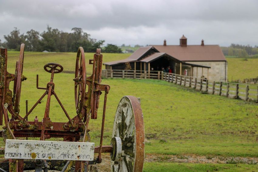
Back to itinerary

2. Totara Estate (continuation)
        30 mins - 1 hour

        Totara Estate is about 8 kilometres south of Ōamaru
        on State Highway 1. Look for the road signs.

Meet and feed the heritage-breed sheep. They have heaps of
personality, and enjoy a back scratch.

Afterwards relax and enjoy one of their farmhouse teas
including scones, jam and cream - you are welcome to bring
your own light refreshments to enjoy in your picnic area.

Visiting Totara Estate
Open Daily. Tours by arrangement.
Group tours may be arranged by contacting the staff at
totaraestate@historic.org.nz, or phone 03 433 1269 to arrange
a convenient time. Totara Estate staff would be delighted to
work with you to develop a programme suited to the interests
and ages of your group.
Demonstrations of heritage agricultural crafts and skills such as
blacksmithing, blade shearing, wood turning, butter-making,
spinning, & stone cutting may be arranged with prior notice.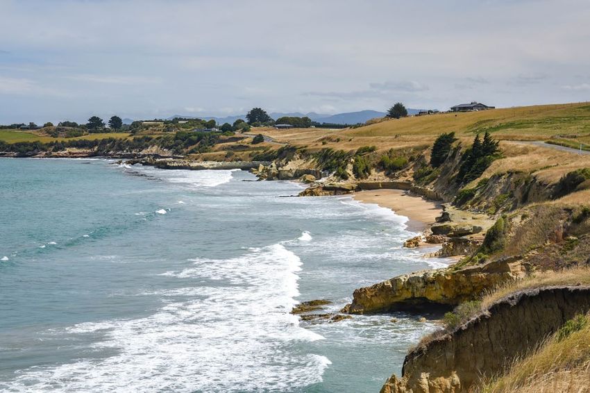
Back to itinerary

3. Brydone Monument
         30 mins - 1 hour

         536 Alma-Maheno Road, Alma 9492

You can take a stroll up Sebastopol Hill to the Brydone Monument
and get a wonderful view of the beautiful Waitaki farmland. This
monument has crowned the hill since 1907 and honours Thomas
Brydone, the man who oversaw Totara Estate at the beginnings of
the international meat trade. Thomas Brydone was a giant figure
of 19th century Otago agriculture. He was also, according to
writer Stuart Laing, “a physically large man who intimidated estate
managers' wives [and] ate his porridge with a bone spoon…”
Crikey!

Brydone Monument is on private property so permission must be
sought at Totora Estate for access.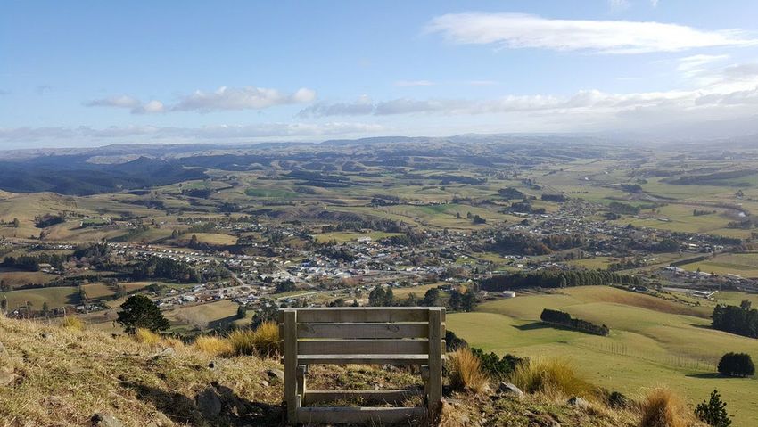
Back to itinerary
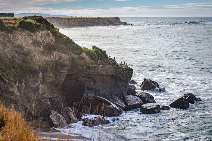
4. Clarks Mill
30 mins -1 hour on an open day
(Typically this is a Sunday afternoon)
State Highway 1 between Reidston and Maheno (watch for
sign) Maheno, New Zealand
Clarks Mill is New Zealand's only surviving water-powered flour
mill with early machinery still substantially intact. It was built as
part of Totara Estate in 1866.
The centrepiece of this important industrial landmark is the
magnificent four-storey mill building constructed of local
limestone. The building contains a rare collection of roller milling
machinery installed in 1893. The machinery has been lovingly
restored to operating condition by a team of dedicated volunteers
who get the machinery grinding into action on a regular basis.
Other highlights include the original water race, the railway line
built in 1877, a remaining millers' cottage known as Smokey Joe's
(once a speakeasy during the dry years of prohibition) and
interesting displays inside the mill itself.
Check out operating times to ensure you enjoy the whole
experience and see, hear and feel what work in the mill was like
when the machinery rolls into action.
Phone: +64 3 433 1269 - Email: clarksmill@heritage.org.nz
Website: www.clarksmill.co.nz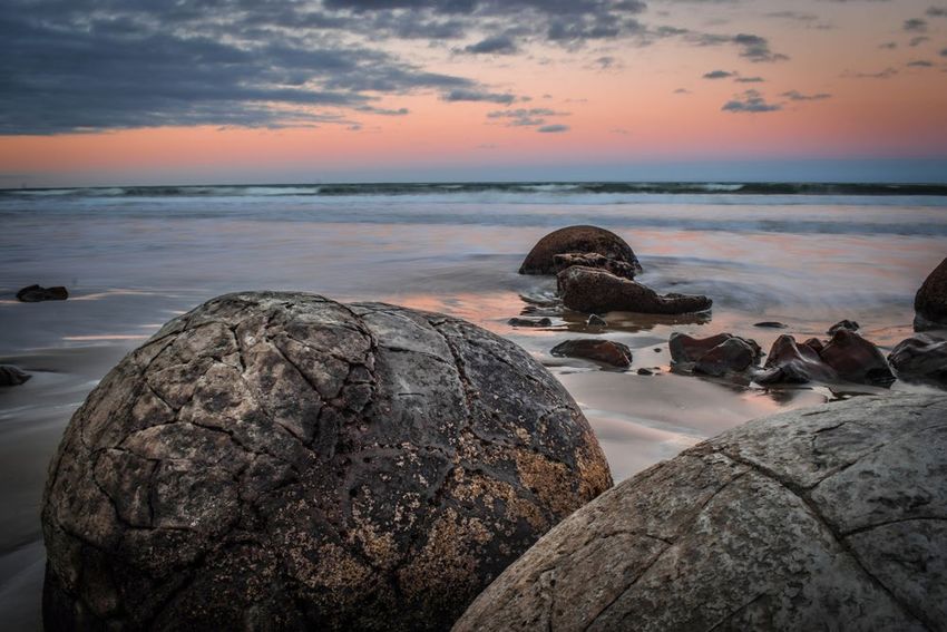
Back to itinerary

5. All Day Bay (Campbells Bay)
         30 mins - 1 hour

         Waianakarua Road, just south of the McKenzies Road
         intersection. Just 10 minutes south of Ōamaru via
         Beach Road.

Kakanui is a beachside village and the surrounding area is
well-known for its rich and fertile soils with many market gardens
in the local area. You'll find a good selection of seasonal
produce available for purchase on roadside stalls. Local talk has
it that Kakanui potatoes and tomatoes are among the best in the
world.

These rich sand also form many of the country's top cricket
pitches due to their physical properties.

Campbells Bay is immediately south of the headland in Kakanui
and provides a surfable break and a safe swimming beach.

The beach is around 2km long and the Southern end is known as
All Day Bay and provides a more sheltered spot for swimming.

Hector's dolphins will often be seen playing in the waves and
can be spotted right along the Kakanui coastline. There are
occasional leopard seal sightings as well. They are large and
pale-coloured and can be fairly aggressive. So if you see one,
keep your distance!

Public toilets available.
Back to itinerary
6. Bridge Point
10 - 30 mins
Waianakarua Road, Kakanui.
Bridge Point is the relic of a small underwater volcano from about
36.7 – 34.6 Million years ago and a world class example showing
the development of the volcanic cone and then its degradation by
various erosion processes. The deposits at Bridge Point show an
initial short stage of eruption of ash and scoria and cone building,
perhaps only a few days, and then degradation of the cone,
initially perhaps by a final destructive eruption in the vent and then
by storm waves and underwater landslides. After the eruption and
degradation phases of the small volcano have ceased the
remaining seamount was covered with several layers of fossil-rich
sandstone and siltstone and finally fossil-poor mudstone.
Bridge point lies just south of Kakanui’s All Day Bay. It is a great
spot for photos with its volcanic rock formation that resembles a
bridge. It looks especially good at low tide. Check out the tide
times on the MetService website.
Parking is available. It’s about a two minute walk along an uneven
path to a great photo spot.Back to itinerary
7. Moeraki Boulders
30 mins - 1 hour
Moeraki Boulders are signposted on State Highway 1, three
kilometres south of Hampden.
Stroll along the beach from Moeraki Boulders Scenic Reserve
carpark and picnic area. Alternatively, take the track directly
to the beach from the cafe at the end of a private road. Or
take a short loop track (150 metres) from the cafe to view the
boulders from above. These tracks are suitable for pushchairs
but not wheelchairs, as they start with several steps.
Walk amongst geological marvels, exposed by erosion of
sedimentary rocks laid down 60 million years ago.
Local Māori legends explain these unusually large and spherical
boulders as the remains of eel baskets, calabashes, and kumara
washed ashore from the wreck of Arai-te-uru, a large sailing
canoe. The rocky shoals that extend seaward from Shag Point
are the petrified hull of this wreck and a nearby rocky
promontory is the body of the canoe's captain.
The Moeraki Boulders are a popular scenic destination for a
reason. These striking spherical rocks reach over 1 metre in
diameter and have formed a spectacular backdrop to photos, so
don’t forget your camera. Early in the morning is a good time to
visit as the beach can get crowded later in the day. It can also be
the best time to photograph the boulders as the light from the
sunrise hits these striking formationsBack to itinerary
7. Moeraki Boulders (continuation)
0.5 hour - 1 hour
Moeraki Boulders are signposted on State Highway 1, three
kilometres south of Hampden.
Stroll along the beach from Moeraki Boulders Scenic Reserve
carpark and picnic area. Alternatively, take the track directly
to the beach from the cafe at the end of a private road. Or
take a short loop track (150 metres) from the cafe to view the
boulders from above. These tracks are suitable for pushchairs
but not wheelchairs, as they start with several steps.
The boulders at Moeraki and Matakaea Shag Point formed on
ancient seafloor between 55 and 70 million years ago. At the
heart of each boulder is a pebble or fossil, which slowly accreted
mud and lime over the millennia. Larger Moeraki Boulders are as
big as 3 metres in diameter and weigh several tonnes whilst the
smaller boulders are about the size of a football. These boulders
have been exposed through shoreline erosion from coastal cliffs.
Even today, there are still boulders remaining in the mudstone
that will, eventually, fall on to the beach as they come loose due
to erosion!
The Moeraki Boulders Cafe offers takeaway or sit down meals
with beautiful ocean views, and there is a gift shop featuring
souvenirs, clothing and jewellery from New Zealand artists and
crafts people.
The Moeraki Boulders are best to be visited at low tide. Check
out the tide times on the Metservice website.Back to itinerary
8. Katiki Point
1 hour
Arrive via Lighthouse Road in Moeraki Village. Katiki
Point is the southern part of the Katiki Peninsula.
See the historic Katiki Point Lighthouse, which still operates
today, and wander up the hill to the Te Raka a Hineatea Pā
site. A pā is a terraced Maori hill-fort; a very important
settlement site for local Maori. The reserve is vested in Te
Rūnanga o Ngāi Tahu who manage the reserve in conjunction
with Te Rūnanga o Moeraki. For more information about Maori
settlement and management of this area, visit the Ōtākou
Runaka website.
Katiki Point is a breeding ground for marine wildlife including
fur seals and the critically endangered yellow-eyed penguin.
A variety of sea and shore birds breed here: little blue
penguin/kororā, yellow-eyed penguin/hoiho, sooty
shearwater/tītī, diving petrel, red-billed gull/tarapuka, spotted
shag/koau pāteketeke, white-fronted tern/tara, and the
variable oystercatcher/tōrea pango.
When viewing the wildlife, please maintain your distance, do
not use flash photography and be respectful at all times.
The reserve is closed overnight.Back to itinerary
9. Matakaea Shag Point
30 mins
Matakaea Shag Point is signposted 9 km north of Palmerston
on SH1. Turn at the sign onto Shag Point Road, and follow until
you reach the reserve carpark.
Large round boulders (of Arai Te Uru legend) can be found
embedded in the soft sandstone of the rock shelf along the
shoreline. The smooth wave-worn mudstones of this headland also
contain well-preserved fossils. A seven-metre marine reptile, a
plesiosaur, was found here and is now part of the University of
Otago fossil collection.
This area was used by the early moa hunters. Nearby,
Shag/Waihemo River Mouth yielded important archaeological
evidence of Ngai Tahu lifestyles dating back to the 12th century.
Moa skeletons and many artefacts have been found here.
Whalers discovered the first bituminous coal in New Zealand here
in the 1830s. By 1862 the exposed coal seams were found to be
commercially viable and were successfully mined until 1972, when
flooding eventually closed shafts that extended under the coast.
Evidence of coal mining is still obvious throughout the reserve. A
small natural boat harbour was once a traditional tauraka waka
(canoe landing place).Back to itinerary
9. Matakaea Shag Point (continuation)
30 mins
Shag Point is signposted 9 km north of Palmerston on SH1.
Turn at the sign onto Shag Point Road, and follow until you
reach the reserve carpark.
Early miners shipped coal from here in sailing and steam colliers.
Today the harbour is used by recreational anglers and divers to
launch their boats.
There are many rare plant and animal species in this very special
area. Yellow-eyed penguins and sooty shearwaters breed here. It
is a major haul-out for seals and a shag roosting area. Unusual
coastal vegetation includes alpine species such as snow tussock,
Celmesia hookeri, as well as broadleaf, ngaio, flax and clematis.
This area includes Shag Point Recreation and Scientific Reserves.
IMPORTANT INFORMATION
Visitors are requested to eat and drink only in designated areas,
away from burial grounds and other sacred sites.
There is no onsite accomodation, and camping is not permitted.
Trotters Gorge campsite is nearby, and there are places to stay
at Palmerston, Moeraki and Hampden.
Please do not disturb the wildlife. Dogs are not permitted in the
reserve.Back to itinerary
10. Puketapu
1 hour
Start your journey up the hill from the old railway
station or the lookout carpark, just off State Highway
1, Palmerston.
Puketapu means “sacred hill” in Maori and offers stunning
360 degree vistas over Palmerston township, rolling
farmland down the Shag Valley and out to sea. It’s easily
visible as you arrive because of the standing stone
monument on top of the hill.
Puketapu is a short and sweet uphill climb. Choose from a
couple of routes - clamber up the face or follow the posts
which mark an easier route - winding around the back of the
hill. Although it can be steep, the track is well formed and
you will be rewarded with stunning views at the top!
Enjoy a picnic lunch on the benches at the top or climb the
stairs and stand atop the monument. The monument is a
memorial to Sir John McKenzie, a local agricultural figure
from the 19th century.Back to itinerary
10. Puketapu (continuation)
1 hour
Start your journey up the hill from the old railway
station or the lookout carpark, just off State Highway
1, Palmerston.
Every year in October, locals run a race called “Kelly’s
Canter” where they run up Puketapu and down again, with
record times sitting at around 20 minutes to get up and
back. The race is in remembrance of local constable Bert
Kelly, who during World War II would regularly run up
Puketapu on coastal watch for enemy ships.
While you're welcome to try and beat that heroic time of 20
minutes, we suggest a good hour to enjoy it at a leisurely
pace.
The track is open all year except during lambing season
(September - November).Back to itinerary
11. Macraes Goldmine
1 hour
Macraes Flat, Macraes, New Zealand.
Turn inland at Palmerston.
View the heavy machinery at work, dwarfed within the large
open-cast pit from the viewing area of New Zealand's largest
gold mine.
The Macraes Mine has produced over 4 million ounces of
gold and is New Zealand's largest gold-producing
operation.
Located in East Otago, Macraes consists of an open-cast pit
and Frasers Underground mine. Frasers sits 200m below sea
level and 740m below the ground surface. The network of
developed tunnel drives is around 48km.
From the purpose built viewing area, visitors can look over
and into the expanse of the open-cast pit, watching the
heavy machinery at work. Dump tracks will systematically
haul their cargo up and out of the pit before returning with
an empty tray, rolling right past the viewing room. You can
also see the underground entrance at the bottom of the pit.
Interpretation information is displayed inside viewing room.Back to itinerary What's next We hope you’ve enjoyed seeing some of the great Coastal highlights the Waitaki has to offer. If you’d like to learn more about what's in the Waitaki, including places to stay and to eat, go to www.waitakinz.com
You can also read