Coastal Erosion in Gabardhanpur and Surrounding Area, Patharpratima, South 24 Parganas, West Bengal, India - Journal Repository
←
→
Page content transcription
If your browser does not render page correctly, please read the page content below
Journal of Geography, Environment and Earth Science
                              International

                              15(3): 1-10, 2018; Article no.JGEESI.41617
                              ISSN: 2454-7352

   Coastal Erosion in Gabardhanpur and Surrounding
      Area, Patharpratima, South 24 Parganas, West
                                       Bengal, India
                                                                                                    Bablu Samanta1*
                               1
                                Vidyasagar Teachers Training Institute, Sanjua, West Bengal-743377, India.

                                                                                                  Author’s contribution

                             The sole author designed, analyzed, interpreted and prepared the manuscript.

                                                                                                     Article Information

                                                                                         DOI: 10.9734/JGEESI/2018/41617
                                                                                                                     Editor(s):
(1) Anthony R. Lupo, Professor, Department of Soil, Environmental and Atmospheric Science, University of Missouri, Columbia,
                                                                                                                         USA.
                                                                                                                   Reviewers:
                                                                              (1) Abidemi O. Ilori, University of Uyo, Nigeria.
                                                                    (2) Emmanuel Etim Okon, University of Calabar, Nigeria.
                                          Complete Peer review History: http://www.sciencedomain.org/review-history/24706

                                                                                                              rd
                                                                                              Received 23 April 2018
                                                                                               Accepted 16th May 2018
  Short Research Article                                                                                  nd
                                                                                              Published 22 May 2018

ABSTRACT

 Sundarban mangrove delta represents one of world’s delta where the Tidal action is extremely
 active. This unique tropical ecosystem has been delineated as almost vulnerable and disaster prone
 area in the world due to several aggressive natural hazards like sea level rise, cyclone, coastal
 erosion, salinization etc. Coastal erosion is the one of the most important hazards. This paper aimed
 to evaluate the coastal erosion in this area. It also attempted to find out the causes and
 consequences of coastal erosion in this area. Another objective of this study is to measure and
 quantify the rate and pattern of coastal erosion. Gobardhanpur and its surrounded mouzas (Mouza
 is the least administrative area in India. It is also called as a village) have been chosen for the study
 area. This village is most affected area due to coastal erosion in this region. Descriptive types of
 research method, literature survey, and questionnaire survey methods have been applied to this
 work. Questionnaire has prepared by 4 point Likart scale. Satellite data, mouza map and
 topographical map have been used for chronological analysis and determination of the rate of
 erosion. The maps and satellite images have been processed to digital images and superimposed
 for exploration of a pattern of coastal erosion through image processing software. The result shows
 that the Gobardhanpur and Plot G 6th portion are the most affected area. Another finding is that the
           th
 Plot G 6 Portion almost vanished from the map. The cause of the coastal erosion of this area is
_____________________________________________________________________________________________________

*Corresponding author: E-mail: bablu.samant9@gmail.com, bablu.samanta9@gmail.com;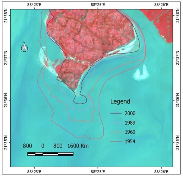
Samanta; JGEESI, 15(3): 1-10, 2018; Article no.JGEESI.41617

mainly natural because forested areas are still extremely eroded. Man-made or anthropogenic
causes are less in number. The result shows the consequences of this hazard. People lost their land
which was used for agriculture, prawn culture, fishing. They have lost homestead property. They
have diverted their occupation. People also migrated from this area as refugees.

Keywords: Vulnerable; Mouza; anthropogenic; satellite data.

1. INTRODUCTION                                             coastline of Bengal delta with the data from 1770
                                                            to 1908-10 AD. His analysis shows that the coast
Coastal erosion can be defined as the removal of            line of Sundarban shifted. Gobardhanpur coast of
material from the coast by wave action, tidal               Patharpratima block was included in this coastal
currents and or the activities of man, typically            area. He also studied on another coastal area
causing a landward retreat of the coastline [1].            like Sagar, Bakkhali, Mousuni etc. The causes of
On the other hand land ward displacement of the             the shoreline shifting and coastal erosion are
shoreline caused by the forces of waves and                 physical factors like a sea wave, the intensity of
currents is termed as Coastal Erosion. The                  tide instead of river effect. Other causes are
Coastal areas have become more prone and                    morphological structure, geology, sea level
vulnerable to natural and human-made hazards                change, the morphology of sea floor. But
which lead to Coastal Erosion [2]. The                      deforestation is not involved in the coastal
occurrence of coastal erosion is dependent upon             erosion [3]. Paul [4], suggested the factors of
the balance between the resistance, or                      coastal erosion like offshore and onshore drift,
erodibility, of the coastline and the strength, or          wave energy variations, wave refraction pattern,
erosivity, of the waves and tides affecting the             longshore current, water table alteration,
area. Consequently, rates of coastal erosion and            development intervention, human-induced land
accretion are very variable at regional, national           use changes, sediment character, high water
and international scales.                                   level situations, high-level situation etc. Hazra [5]
                                                            stated that Sundarbans, the only mangrove tiger-
Coastal erosion typically results in a landward             land of the globe is presently under threat of
retreat of the coastline. This can increase the risk        severe coastal erosion due to relative sea level
of coastal flooding and result in loss of land and          relief. Mukherjee,(2016) has reported that the GP
damage to buildings, infrastructure and                     is very much threatened by impacts of climate
agricultural land. Sudden coastal erosion events,           change induced climatic shock which caused
particularly those in the vicinity of coastal cliffs,       disappearing of one village Gobardhanpur inside
may directly endanger the lives of people. The              the sea 10-12 years ago. “The southern part of
movement of salt-water into freshwater areas                Sitarampur has disappeared, while the northern
(saline intrusion) can occur during coastal                 part is slowly getting swallowed up as the land
flooding and can impact upon the biodiversity of            gets eroded by the onslaught of the sea.” – The
previously freshwater or terrestrial ecosystems.            Hindu, Feb 24, 2008 [6]. Bangladesh Centre for
In Sundarbans coastal erosion is a big problem.             Advanced Studies (2012) found out that one of
Both physical and socio-economic environment                the worst affected mouzas is Gobardhanpur. The
has been affected by coastal erosion.                       Bay of Bengal has eaten away almost three –
                                                            fourth parts of Gobardhanpur Mouza and the
2. LITERATURE REVIEW                                        inhabitants of this mouza have lost their lands,
                                                            assets & livelihoods and become the victims of
Several types of research conducted on coastal              coastal erosion. They are compelled to migrate
erosion in the different coastal region specifically        permanently without any rehabilitation package
link coastal erosion in West Bengal coast. Some             [7]. Saha, Bhandari and Ghosh (2015) surveyed
researchers also assessed the coastal erosion in            Gobardhanpur village. It was the most affected
Sundarban region for both India and                         mouza during ‘aila’ in 2009 in Patharpratima CD
Bangladesh.                                                 block. This cyclone accelerated the coastal land
                                                            erosion process. Saini [8] pointed out that the
2.1 Empirical Study                                         village Gobardhanpur has an overall high
                                                            vulnerability to climate change. Das and
Bandhyopadhyay (2000) studied the changing                  Bandyopadhay (2012) stated that the main
coastline of the Gangetic delta of West Bengal.             causes of coastal erosion of southern facing
He prepared a map to show the changing                      areas of Sundarban are abandonment of

                                                        2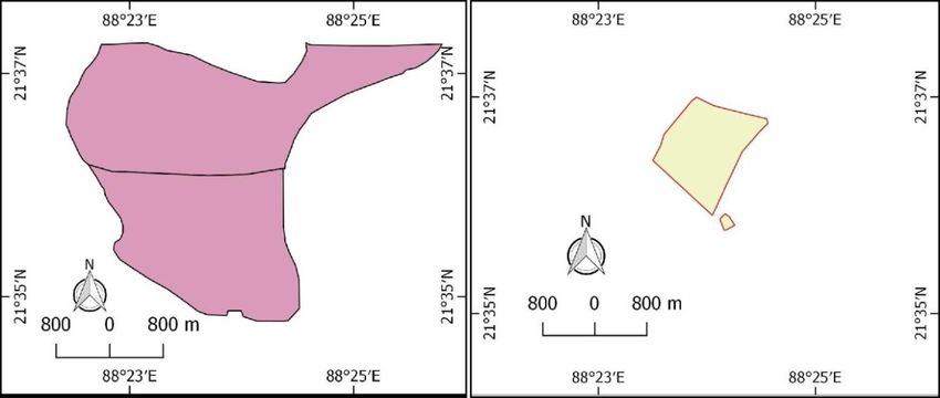
Samanta; JGEESI, 15(3): 1-10, 2018; Article no.JGEESI.41617

sediment-replenishing western distributaries of             with the sea. The total land area of the island has
Ganga, due to western tilting of the Delta and off-         been reduced from 47.3 km2 in 1979 to a little
shore interception of westward transportation of            more than 40 km2 in 2011, ensuring a loss of
sediment by the swatch of No Ground submarine               almost 7 km2 of land due to erosion. It is
canyon (Bandyopadhay and Bandyopadhay,                      observed that the south and southeastern banks
1996; Bandyopadhay et al., 2003) [9]. Bera [10]             of the island faced maximum burnt of erosion. As
examined that Gobordhanpur village is the most              the Gobardhanpur is located in southern part of
destructive village due to chronic floods and               this island, so it is affected by coastal erosion
rapid land erosion. A large number of people had            [12]. Indian Space Research Organisation (2014)
been displaced due to rapid land erosion during             has prepared the shoreline change atlas map on
the 1980s. Saini [11] studied on the immediate              the basis of satellite image SPOT-1 with sensor
                                                                                    th
threats and vulnerabilities faced by the poor               HRV1-MLA, dated 27 January, 1989 and IRS-
people in Sundarban coastal region due to                   P6 with sensor LISS-IV, dated 26th January
climate change. The village Gobardhanpur in                 2006. This map proved that the coastal area of
Patharpratima block of Sundarban has covered                Gobardhanpur is retreating. Chacraverti (2014)
by a study which has an overall high vulnerability          said that archaeological findings by two villagers
to climate change.                                          at Gobardhanpur, at G-Plot, in the Pathar
                                                            Pratima Block and subsequent investigations by
2.2 Satellite Study                                         archaeologists have indicated a thriving
                                                            settlement as old as the third century BC.25
Chatterjee (2015) have shown that landforms of              However; all these findings are from sites close
Sundarbans are changing shape rapidly following             to the sea of Gobardhanpur. Therefore, these are
the impact of several forcing parameters, both              indicating that human activity was there in the
natural (atmospheric, physical, chemical and                past. That can be a factor of coastal erosion here
geological) and anthropogenic (pollution, tourism,          [13]. Rahman (2012) has studied on Sundarban
deforestation). She has assessed the changes in             which is located in Bangladesh to show the time-
shoreline pattern of 14 islands in Indian                   series change analysis by remote sensing
Sundarbans (ISD) since 1979. Using multi                    method using satellite data of 1970 and 2011. He
temporal satellite images of LANDSAT, she                   has also calculated the rate of erosion rates in
found that as many as four islands within Indian            the Sundarbans. He also divided the area into
Sundarban have lost area in excess of 30%.                  the eastern and western part. The average rates
While the area loss for another three islands has           of erosion for the eastern and western parts are
been between 10 and 30%, five islands show                  14 m/year and 15 m/year respectively. He did not
minor loss of area (
Samanta; JGEESI, 15(3): 1-10, 2018; Article no.JGEESI.41617
construction and activity can be one of the major village. South side of this area is facing towards
causes of coastal erosion [15]. Guriya [16] Bay of Bengal.
assessed on the basis of archaeological findings
like fossilized bone, brick kilns, domestic 4. OBJECTIVES
materials from 20 feet depth of eroded part in the
sea that there were a port or ancient town in To identify the causes of coastal erosion in
Gobardhanpur which is situated in the southern the study area.
tip of Surendarnagar Island of Patharpratima CD To measure and quantify the coastal
block. He mentioned that 5000-7000 bigha (802- erosion.
1124 hectare) land was reclaimed after 1930 but To find out the effect of coastal erosion on
all amount of land has been gone to the Bay of the study area.
Bengal.
5. METHODOLOGY AND DATA BASE
3. STUDY AREA
In this study, previous literatures have been used
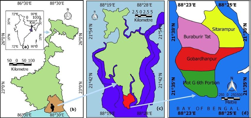
Administratively the study area (Gobardhanpur to find out the causes of the coastal erosion of
and its surrounding areas like Buraburir the study area. Satellite images of the study area
Tat, Sitarampur and Plot G 6th portion) is from LANDSAT (1989, 2000 and 2017) satellites
located in Patharpratima CD in South 24 and cadastral maps (1947-51) and Survey of
Parganas district of west Bengal, India. The India topographical map 1968-69 were used and
study area extended in latitude from 213530 N analyzed on a GIS platform to determine shift in
to 213904 N and in longitude from 882256 E shoreline and quantify the coastal erosion area of
to 882551 E. These are four villages or the Gobardhanpur and its surrounding area over
Mouzas. All the four villages were affected by a period of 63 years. All LANDSAT images were
coastal erosion. Gobardhanpur and Plot G 6th ortho-rectified and geo-referenced through UTM
portion village was the worst affected mouzas, projection and WGS-84 datum in the USGS web
but the second one has no settlement. The platform. These images have been downloaded.
Jagaddal River and Saptamukhi River boarded Then for easy visual interpretation, the image
the east and west respectively of this area. processing techniques have been applied
North, side of this area is bounded by Indrapur through same image processing software QGIS-
Fig. 1. Location of the Study area - (a) West Bengal in India, (b) Patharpratima CD Block and
South 24 Parganas District in West Bengal, (c) Study area in Patharpratima CD Block, (d) Study
area
4Samanta; JGEESI, 15(3): 1-10, 2018; Article no.JGEESI.41617
2.14.10. Band combination like the near-infrared severe coastal erosion due to relative sea level
(NIR), red and green bands were stacked to rise [5]. The main causes of the coastal erosion
produce a standard False Colour Composite of the sea (Bay of Bengal) facing islands of
image (FCC). Vegetation appears red due to Sundarban are an abandonment of sediment-
high reflection in NIR by green leaves. A replenishing western distributaries of Ganga due
standard FCC was created from Thematic to western tilting of the Delta and off-shore
Mapper (TM) and Enhanced Thematic Mapper interception of westward transportation of
(ETM+) data by stacking the bands 4, 3 and 2. A sediment by the Swatch of No Ground
standard FCC was obtained from Multispectral Submarine Canyon [12]. The other causes of
Scanner (MSS) data by stacking the bands 5, 4 coastal erosion are a frequent cyclonic storm,
and 4 to help identify various different land manmade engineering construction in the coastal
features. The Survey of India topographical map area [5].
and cadastral map have been geo-referenced
through same projection and datum using image 6.2 Anthropogenic Causes
processing software QGIS-2.14.10 and used as
base data. Shapefiles were created for this area The role of human being on coastal retreatment
from cadastral map by digitizing along the village is very least, because, these activities have
land boundary. Shapefiles for topographical map happened within last few decades. Deforestation
and images have been created by digitizing is not related to coastal erosion in this area. Sea
along high tide line. The high tide lines were level rise due to greenhouse effect is not
mapped using Survey of India topographic important factor till now but it can be an important
sheets as reference. These shape files contain cause of coastal erosion in this area.
polygon layers which indicate coastline situation Embankment construction can be a major man-
for a given year. Then superimposition of made factor for coastal erosion [3]. Here also it
digitized polygon layers as coast lines has been has to point out that the archaeological findings
done. The prepared superimposed map shows at Gobardhanpur, and subsequent investigations
the coastal erosion quantity and chronological by archaeologists have indicated a thriving
shoreline shifting situation in the study area. settlement as old as the third century BC.
They are eroded per year in different villages or However, all these finds are from sites close to
mouza within the study area were extracted and the sea. So it can be say that human settlement
plot of area eroded versus time is made. with engineering construction built up in
At last, self-prepared questionnaires were Gobardhanpur. This is also an important factor
surveyed on 40 residents of the study area. for coastal erosion. So the causes of the
Survey questionnaire has been made coastal erosion of Gobardhanpur are both
with 4-point Likart scale which expressed as natural and anthropogenic [15], [18]. Shoreline
Strongly Agree, Agree, Disagree and water table alteration, development
Strongly Disagree where strongly agree intervention, other human-induced land use
rated as 4 and strongly disagree rated as 1. changes may be human-induced factor for
Percentage analysis statistics has been used to coastal erosion [19].
find out the effects of coastal erosion. The details
of used maps and images are in the following 7. MEASUREMENT OF EROSION
table.
Superposition and subsequent analysis of maps
6. CAUSES OF EROSION and satellite images of the study area bring out a
significantly faster rate of erosion in all the four
6.1 Natural Causes mouzas of the study area (Fig. 2). Tables 1 and 2
provide the summary of the findings.
Bottom topography and geology of closed sea of
Gobardhanpur is the most important factor of From the study, it is astonishingly revealed that
coastal erosion in this area [9], [19]. Tidal action the forested mouza (Plot G 6th portion) was
and ocean current play a dominant role in eroded more than the reclaimed one. The
shoreline retreatment in the study area [3]. It has forested mouza also showed progressive
to be pointed out that the causes of rapid erosion erosion. The coastline of all mouza retrograded
of islands are high difference between high tide during this time period between 1954 and 2017.
and low tide, magnitude and intensity of sea The Maximum coastal retreat of the area is noted
wave [3]. Sundarban, the only mangrove tiger- in Plot G and Gobardhanpur. Gobardhanpur
land of the globe is presently under threat of village situated along Bay of Bengal has already
5Samanta; JGEESI, 15(3): 1-10, 2018; Article no.JGEESI.41617
lost almost three fourth of its land area due to soil out a major portion of the southern half of the
erosion. study area.
The above map shows the pattern of coastal The following line graphs show the change of
erosion in the study area. The trend of erosion area of the respective mouzas. If the
has progressed from south to north. Erosion is changing area is arranged by decreasing order,
th
the main process no doubt, but slight deposition so the mouzas would be arranged like Plot G 6
also taken place in the western side of this area Portion, Gobardhanpur, Buraburir Tat and
side by side. South and south eastern side has Sitarampur. The Fig. 4 shows the
the most eroded shoreline in this area. North comparison of erosion in between Gobardhanpur
th
western and eastern sides are almost stable from and Plot G 6 portion. This comparison shows
the erosion point of view. One can assume that the coastal erosion status for a period of 1954
the present trend of erosion would certainly wash and 2017.
Fig. 2. Recession of shoreline from 1954 to 2017 (The image of 2017 belongs to FCC)
Table 1. Maps and satellite images used for this study
Maps / Satellite Images Year of survey / Path / Row Scale / Spatial Sources
acquisition Resolution
Cadastral map 1947-51 ------ 1:3960 Land Record office
Topographical map 1968-69 ------ 1:50, 000 Survey of India
Landsat - 4 TM 1989 138 / 45 30 m United States
Landsat - 7 ETM+ 2000 138 / 45 30m Geological Survey
Landsat – 8 OLI_TRISS 2017 138 / 45 30 m
6Samanta; JGEESI, 15(3): 1-10, 2018; Article no.JGEESI.41617
8
7
Buraburir Tat
6
Area in Sq. km
5 Sitarampur
4
3 Gobardhanpur
2
Plot G 6th Portion
1
0
1954 1969 1989 2000 2017
Year
Fig. 3. Change of area of the respective mouzas
Gobardhanpur
Gobardhanpur
Plot G 6th portion
Plot G 6th portion
Fig. 4. Status of Gobardhanpur 1954 and present status of that area (2017)
Table 2. Area of mouzas in chronological order
2
Mouza Area in Km
1954 1969 1989 2000 2017
Buraburir tat 7.04 6.41 4.99 4.89 4.57
Sitarampur 6.55 6.61 6.02 5.17 4.98
Gobardhanpur 6.75 4.76 2.79 1.73 1.65
Plot g 6th portion 5.05 1.71 0.83 0.27 0.03
7Samanta; JGEESI, 15(3): 1-10, 2018; Article no.JGEESI.41617
Table 3. Rate of erosion
2 -1
Mouza Rate of erosion Km yr
1954-1969 1969-1989 1989-2000 2000-2017
Buraburir Tat 0.042 0.071 0.009 0.018
Sitarampur -0.004 0.029 0.077 0.011
Gobardhanpur 0.133 0.098 0.096 0.004
Plot G 6th portion 0.022 0.044 0.051 0.014
100%
Percentage of respondents
90%
80%
70%
60%
50%
40%
30%
Strongly Disagree
20%
10% Disagree
0% Agree
Displacement
Agricultural land loss
Change of occupation
Homestead land loss
Fishing land loss
Strongly Agree
no. of sample = 40
Fig. 1. Effects of coastal erosion
8. EFFECTS OF EROSION following figure (Fig. 5) shows that more than 95
% people were agreed to loss of their agricultural
Gobardhanpur mouza like other mouzas of land. Gobardhanpur village has already lost
Sundarban has lost their huge land into the sea almost three fourth of its land area due to soil
[3]. The major effects of coastal erosion on erosion. It also strongly affects their economy, as
Bengal coastal area are property loss, maximum people were depended on agriculture.
displacement of population, loss of livelihoods,
tourism loss, and environmental degradation [7]. They also lost their homestead land and fishing
The inhabitants of this mouza have lost their areas. Almost 90-95% people were agreed and
lands, assets & livelihoods Gobardhanpur was strongly agreed with these effects of coastal
surveyed as it was the most affected mouza erosion. Next important effect of coastal erosion
during ‘aila’ in 2009. Gobardhanpur of is displacement of people. They have been
Patharpratima is the mouza where agriculture shifted or migrated from this place to
dominates and in all these mouzas the economic neighbouring village or far away of this region.
condition of the inhabitants is below average Above 85 % people were agreed with this
[10]. It can also increase the risk of coastal problem. Residents of this coastal area did
flooding which may cause damage to change their occupation. People of this area
infrastructure, agricultural land, buildings etc. Salt basically depended on agriculture and fishing.
water intrusion can make the soil infertile and They have changed their occupation to other
drinking water unfits [17]. Questionnaire survey secondary economic activity. Some people also
outcome undermines us the effect of coastal migrated from this area for the sake of better job
erosion from a socio-economic point of view. The opportunity.
8Samanta; JGEESI, 15(3): 1-10, 2018; Article no.JGEESI.41617
9. CONCLUSION Reconnaissance Report under CCDRER
project. 2012;41-42.
The findings show that all the three mouzas have (Accessed 18th March 2018)
been facing the threat of coastal erosion. Available:https://www.bcas.net/uplded/pdfs
Satellite images and other maps help to indicate /RECON_FINAL(CCDRER).pdf
the future disastrous fate of the villages of 8. Saha S, Bhandari G, Ghosh TA. General
th
Gobardhanpur and Plot G 6 portion. The trend Overview of the Society and the of the
shows that Plot G will vanish in very near future. sunderbans, South 24 Parganas, West
Gobardhanpur is the second most affected Bengal, India. International Journal of
village which has already lost about 80% of land Research Studies in Science, Engineering
area into the sea. People are trying to manage and Technology. 2015;2(10):17-23.
alternative forms of livelihood. Proper solution 9. Das CS, Bandyopadhyay S. Sharing
measures have curtailed the rate of erosion space: Human-animal conflicts in Indian
st
compared to the past. Local government and Sundarban. 1 ed. Kolkata: Progressive
other NGOs have been initiating to Publishers; 2012.
take the responsibility to find out a solution in this 10. Bera MK. Living with floods: A Study of
respect. Rural Communities in Sundarban.
Sodhganga. 2014;40-42.
COMPETING INTERESTS (Accessed January 4, 2018 Sodhganga)
Available:http://hdl.handle.net/10603/5544
Author has declared that no competing interests 5
exist. 11. Saini G. Immediate threats and
vulnerabilities in the Sundarbans due
REFERENCES climate change at Patharp blocks,
Sundarbans. 1st ed. New Delhi: TERI
1. British Geological Survey. Coastal Erision. University; 2014.
UK Geohazard Note; 2012. (Accessed 3rd February,2018)
(Accessed February 2, 2018) Available:ww.lib.newsvol.16no.1
Available:http://www.bgs.ac.uk/research/cli 12. Chatterjee N, Mukhopadhyay R,
matechange/environment/coastal/home.ht Mitra D. Decadal changes in shoreline
ml patterns in Sundarbans, India.
2. Prasad DH, Kumar ND. International Journal of Coastal Sciences. 2015;2(2):54-
Journal of Geosciences. 2014;5(3):341- 64.
345. 13. Space Applications Centre (ISRO),
Available:http://dx.doi.org/10.4236/ijg.2014 Coastal Erosion Directorate and Central
.53033 Water Commission, Ministry of Water
3. Bandyopadhyay S. Pashimbange Gangeyo Resources. Shoreline change Atlas of
Badwiper Upokul Rekha: Pribartaner India (Odisha and West Bengal). Atlas.
Samiksha. Kaldhwani. 2000;10(2-3):52-62. 2014;5:139.
4. Paul A. Coastal geomorphology and 14. Rahman MM. Time-series analysis of
environment. Sundarban Coastal Plain, coastal erosion in the Sundarbans
Kanthi Coastal Plain, Subarnarekha Delta Mangrove. International Archives of the
st Photogrammetry, Remote Sensing and
Plain. 1 ed. Kolkata: ACB Publications;
2002. Spatial Information Sciences. 2012;39(22):
5. Hazra S. et al. Sea level and associated 425-429.
changes in the Sundarbans. Science and 15. Chacraverti S. The Sundarbans
Culture. 2002;68(9-12):309. fishers coping in an overly stressed
st
6. Mukherjee M. Climatic shock and health mangrove estuary. 1 ed. Chennai:
demand-supply nexus in the Sundarbans International Collective in Support of
Delta Region in India. Climate Change. Fishworkers; 2014.
2016;2(5):11-24. 16. Guriya M. Dakshin 24 Pargana Samagra.
7. Bangladesh centre for advanced studies. 1st ed. Kolkata: Pandulipi; 2013.
Collective action to reduce climate disaster 17. Barman B. Effects of coastal erosion on
risks and enhancing resilience of the the fishing community livelihoods: A Focus
vulnerable coastal communities around the on the East Midnapore coast, West
Sundarbans in Bangladesh and India. Bengal-A study of the present to
9Samanta; JGEESI, 15(3): 1-10, 2018; Article no.JGEESI.41617
understand the Future in the era of Climate 19. Pahari DP. (2015). Coastal Resorts of
Change; 2014. West Bengal An Environmental Appraisal.
(Accessed from 2ndFebruary2018) (Retrieved January 11, 2017 Sodhganga)
Available:https://www.academia.edu/82827 Available:https://www.google.co.in/search?
98/Effects_of_Coastal_Erosion_on_Fishin q=Coastal+Resorts+of+West+Bengal+An+
g_Livelihoods_A_case_Study_on_Eastern Environmental+Appraisal&rlz=1C1CHBD_
_Midnapore_Coast_of_West_Bengal_India enIN739IN739&oq=Coastal+Resorts+of+
18. Hazra S. et al.Temporal change detection West+Bengal+An+Environmental+Apprais
(2001-2008) study of Sundarban. Kolkata: al&aqs=chrome..69i57.2368j0j7&sourceid=
School of Oceanographic Studies, chrome&ie=UTF-8
Jadavpur University; 2010.
_________________________________________________________________________________
© 2018 Samanta; This is an Open Access article distributed under the terms of the Creative Commons Attribution License
(http://creativecommons.org/licenses/by/4.0), which permits unrestricted use, distribution, and reproduction in any medium,
provided the original work is properly cited.
Peer-review history:
The peer review history for this paper can be accessed here:
http://www.sciencedomain.org/review-history/24706
10You can also read