Coastal Offset Strategy - Strategy - INPEX
←
→
Page content transcription
If your browser does not render page correctly, please read the page content below
se
                                      rU
                                          Coastal Offset Strategy
                                                                                  Strategy
                                    fo
                                               Document No.: X075-AH-STR-0001
                                               Security Classification: Unrestricted
               d
            ue
Iss

Revision     Date       Issue Reason      Prepared      Checked     Endorsed       Approved

   8       25/06/2021    Issued for Use    B Davis       J Carle   D Robotham         V Ee

                        This document has been approved and the audit history is recorded on the last page.
Coastal Offset Strategy
RECORD OF AMENDMENT
Revision Section Amendment
1 - Re-issue for information
2 - Re-issue for information
se
3 - Re-issue for information
4 - Re-issue for information
5 - Revision withdrawn
rU
Tables 3-1 and 3-6 Update completion status of Long-term monitoring of coastal
6 Sections 3.3 and dolphins in Darwin Harbour and the abundance and
3.3.1 distribution of dugongs in the Northern Territory
Revised to reflect approved variation to Condition 11a,
Table 3-1 and 3-8 changing “Conservation management of marine megafauna in
Sections 3.1.1 and the western Top End” to “Conservation management of
3.4.2 dugongs, cetaceans and threatened marine matters of
7 national environmental significance in the Top End”.
fo
Updated to reflect current status and planned works for
Section 4
Conditions 11b and 11c
Sections 1.2,2,4 Updated to reflect Conditions 11b and 11c variation 23 June
8 2021
Figure 4.1
d
ue
Iss
Document No: X075-AH-STR-0001 ii
Security Classification: Unrestricted
Revision: 8
Last Modified: 25/06/2021Coastal Offset Strategy
DOCUMENT DISTRIBUTION
Copy Name Hard Electronic
no. copy copy
00 Document Control X X
se
01 Department of Agriculture, Water and the Environment X
02
03
04
rU
05
06
07
08
fo
09
10
d
NOTICE
All information contained within this document has been classified by INPEX as Unrestricted
and must only be used in accordance with that classification. Any use contrary to this
document's classification may expose the recipient and subsequent user(s) to legal action.
ue
If you are unsure of restrictions on use imposed by the classification of this document you
must refer to 0000-A9-STD-60008, Sensitive Information Protection Standard or seek
clarification from INPEX.
Uncontrolled when printed.
Iss
Document No: X075-AH-STR-0001 iii
Security Classification: Unrestricted
Revision: 8
Last Modified: 25/06/2021Coastal Offset Strategy
TABLE OF CONTENTS
TERMS, ABBREVIATIONS OR ACRONYMS ............................................................ V
1 INTRODUCTION ...................................................................................... 6
1.1 Project overview ........................................................................................ 6
1.2 Purpose .................................................................................................... 8
se
2 BACKGROUND TO ENVIRONMENTAL OFFSETS ......................................... 9
3 ENVIRONMENTAL OFFSETS PROGRAMS ................................................ 11
3.1 Collaboration with the NTG ........................................................................11
3.2 Funding arrangements ..............................................................................13
3.3 Completed environmental offset programs ................................................... 13
rU
3.4 Ongoing environmental offset programs ......................................................17
4 PROTECTION OF TERRESTRIAL AND MARINE HABITAT......................... 23
4.1 Purpose and objectives ..............................................................................23
4.2 Scope ......................................................................................................23
4.3 Methodology ............................................................................................23
4.4 Funding arrangement ................................................................................26
4.5 Timing .....................................................................................................27
fo
5 REGULATOR CONSULTATION ................................................................ 28
6 REFERENCES ......................................................................................... 29
LIST OF TABLES
Table 3-1: Environmental offset programs within the scope of the Coastal Offset Strategy
..........................................................................................................12
d
Table 3-2: Conservation status of coastal dolphins in the Northern Territory ................14
Table 3-3: Habitat mapping for Darwin region (including Bynoe Harbour) ....................14
Table 3-4: Publication of Kimberley research data ....................................................15
ue
Table 3-5: Funding of ARC Linkage Projects ............................................................. 15
Table 3-6: Long-term monitoring of coastal dolphins in Darwin Harbour and the
abundance of dugongs in the Northern Territory .......................................16
Table 3-7: Implementation plan—Darwin Harbour IMMRP ..........................................17
Table 3-8: Implementation plan –conservation management of dugongs, cetaceans and
threatened marine MNES in the Top End ..................................................19
Table 4-1: Indicative schedule for terrestrial and marine conservation sites ................. 27
Iss
LIST OF FIGURES
Figure 1-1: Location of the Ichthys Field and GEP route .............................................. 7
Figure 3-1: Overview of ARGP assessment process and indicative reporting requirements
..........................................................................................................22
Figure 4-1 Outline of the method for implementing Condition 11(b) and 11(c) ............. 24
TABLE OF APPENDICES
APPENDIX A: LIST OF ELIGIBLE CONSERVATION MANAGEMENT SPECIES ............... 30
Document No: X075-AH-STR-0001 iv
Security Classification: Unrestricted
Revision: 8
Last Modified: 25/06/2021Coastal Offset Strategy
TERMS, ABBREVIATIONS OR ACRONYMS
Term, abbreviation Description
or acronym
ALMAG Aboriginal Land Management Advisory Group
se
ARGP Aboriginal Ranger Grants Program
ARC Australian Research Council
Company-run IPVOA programs managed by the INPEX
CPF central processing facility
CPI Consumer Price Index
rU
Cwlth Commonwealth
DAWE Department of Agriculture, Water and the Environment (Cwlth)
DENR formerly Department of Environment and Natural Resources (NT) now
DEPWS
DEPWS Department of Environment, Parks and Water Security
DCM Department of Chief Minister (NT)
fo
EA Act Environmental Assessment Act (NT)
EIS environmental impact statement
EPBC Act Environment Protection and Biodiversity Conservation Act 1999 (Cwlth)
FPSO floating production, storage and offtake facility
GEP gas export pipeline
d
HOA heads of agreement
IMMRP integrated marine monitoring and research program
IPVOA Ichthys Project Voluntary Offset Agreement
ue
LNG liquified natural gas
LPG liquified petroleum gas
MNES matters of national environmental significance
NT Northern Territory
Iss
NTG Northern Territory Government
PEP project execution plan
Territory-run IPVOA programs managed by the NTG
LMCF Guideline Aboriginal Ranger Grant Program Land Management and Conservation
Fund Guidelines
Document No: X075-AH-STR-0001 v
Security Classification: Unrestricted
Revision: 8
Last Modified: 25/06/2021Coastal Offset Strategy
1 INTRODUCTION
1.1 Project overview
The Ichthys LNG Project (the Project) is a joint venture between INPEX group companies,
Total, and the Australian subsidiaries of CPC Corporation Taiwan, Tokyo Gas, Osaka Gas,
Kansai Electric Power, JERA and Toho Gas. INPEX Operations Australia Pty Ltd acts as the
se
Operator of the Project.
Drawing on the hydrocarbon resources of the Ichthys gas and condensate field in the
Browse Basin at the western edge of the Timor Sea offshore Western Australia, the Project
is expected to produce 8.9 Mt of liquefied natural gas (LNG) and 1.6 Mt of liquefied
petroleum gases (LPG) per annum, along with up to approximately 100,000 barrels of
condensate, per day, at peak. The Project has an expected operational life of at least 40
rU
years.
The extraction of natural gas and condensate is carried out via a floating semi-submersible
central processing facility (CPF) at the Ichthys Field. This removes water and most of the
condensate from the reservoir fluids and the separated water and condensate are
transferred to a floating production, storage and offtake (FPSO) facility moored
approximately 3.5 km from the CPF. After further processing on the FPSO, the condensate
is exported from the FPSO at an average rate of up to 85,000 barrels per day (at the start
of LNG production).
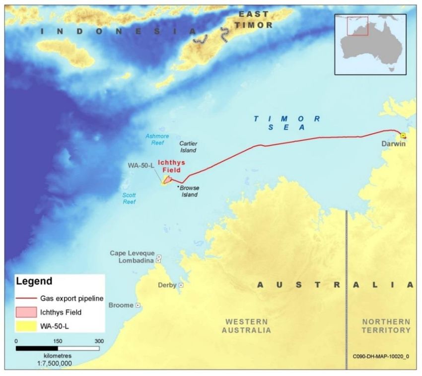
The dehydrated gas and the remainder of the condensate is compressed and exported
fo
through an approximately 890 km long gas export pipeline (GEP) to the Project’s onshore
processing plant at Bladin Point1 in Darwin Harbour in the Northern Territory (NT) (Figure
1-1).
1
Previously Blaydin Point - https://www.ntlis.nt.gov.au/placenames/view.jsp?id=24572
d
ue
Iss
Document No: X075-AH-STR-0001 Page 6 of 32
Security Classification: Unrestricted
Revision: 8
Last Modified: 25/06/2021Coastal Offset Strategy
se
rU
fo
d
Figure 1-1: Location of the Ichthys Field and GEP route
The Project’s infield facilities, including the greater part of the offshore component of the
ue
subsea pipeline, fall under Commonwealth jurisdiction, while the nearshore and onshore
facilities in Darwin fall under both Commonwealth and NT jurisdiction.
The nearshore infrastructure consists of an approximately 27 km length of the GEP from
the mouth of Darwin Harbour to the pipeline shore crossing on the western side of Middle
Arm Peninsula; a two-berth product loading jetty on the north western end of Bladin Point;
and a navigation channel, turning basin and berthing pocket for the product tankers.
The onshore facilities at Bladin Point include an 8 km long onshore pipeline corridor from
Iss
the shore crossing area to the Bladin Point gas-processing plant; two gas liquefaction
trains, each capable of producing approximately 4.45 Mt/a of LNG; an LPG (propane and
butane) fractionation plant; a condensate stabilisation plant; seven storage tanks (two for
LNG, three for condensate, one for propane and one for butane); and associated utilities
and administration facilities.
Document No: X075-AH-STR-0001 Page 7 of 32
Security Classification: Unrestricted
Revision: 8
Last Modified: 25/06/2021Coastal Offset Strategy
The Project was assessed under the Northern Territory Government’s (NTG) Environmental
Assessment Act (EA Act) and the Commonwealth’s Environment Protection and Biodiversity
Conservation Act 1999 (EPBC Act) in 2010 and 2011 as an environmental impact statement
(EIS). The NTG Minister for Natural Resources, Environment and Heritage assessed the
Project under the EA Act on 17 May 2011, attaching a set of recommendations to this
assessment report (NRETAS 2011). The Commonwealth Minister for Sustainability,
Environment, Water, Population and Communities approved the Project under the EPBC
se
Act on 27 June 2011, with a set of conditions (Minister for the Environment 2011).
1.2 Purpose
The purpose of this document is to detail INPEX’s Coastal Offset Strategy in accordance
with Condition 11 of the Commonwealth’s Approval Decision (EPBC 2008/4208), and as
varied on 23 June 20212. Specifically, this document includes:
rU
• high-level details on the implementation of offsets specified in Condition 11(a)
• scope and methodology for the protection and management, for the life of the
project, of approximately 2000 ha of terrestrial vegetation and mangroves, or of an
area as otherwise agreed by the Minister, in accordance with Condition 11(b)
• scope and methodology for protection and management, for the life of the project,
of marine habitat for inshore dolphins, marine turtles and Dugong that is preferably,
but not necessarily, adjacent to the protected mangrove vegetation, as required by
Condition 11(c).
fo
2
See EPBC 2008/4208
d
ue
Iss
Document No: X075-AH-STR-0001 Page 8 of 32
Security Classification: Unrestricted
Revision: 8
Last Modified: 25/06/2021Coastal Offset Strategy
2 BACKGROUND TO ENVIRONMENTAL OFFSETS
The NTG and Commonwealth Government determined that the Project be formally
assessed at the EIS level.
INPEX submitted its Draft EIS in July 2010 and, after a period of public review, published
its EIS Supplement in April 2011. In the EIS Supplement (Section 4.9 page 137 of the EIS
se
Supplement), INPEX committed to a number of environmental offsets which included the
following:
• a long-term boat-based survey of coastal dolphins in Darwin Harbour to improve
understanding of their abundance, distribution and critical resource needs
• participation in a proposed integrated marine monitoring and research program for
Darwin Harbour
rU
• support of the Australian Research Council (ARC) Linkage Projects scheme. INPEX
has committed to supporting two ARC Linkage research proposals in Darwin
Harbour and will make a significant contribution in cash or in kind that will be equal
to, or greater than, ARC funding of the projects
• the publication of the results of the extensive biological and ecological studies
undertaken by INPEX along the Western Australian Kimberley coastline to support
the preparation of its EIS.
A tripartite process was established during the environmental approvals process between
the Department of Chief Minister (DCM) (representing the NTG), Department of
fo
Agriculture, Water and the Environment (DAWE3) and INPEX to negotiate an environmental
offset package that included those committed to in the EIS Supplement.
In May 2011, the NTG provided a letter to the then Acting Secretary of the Commonwealth
environment department outlining the agreements reached between INPEX and the NTG
on various environmental offsets that INPEX would voluntarily commit to should the Project
be approved. The environmental offsets outlined in this letter may be summarised as
follows:
d
• greenhouse gas offsets: $37 million over 20 years for savannah burning projects in
the NT
• environmental offsets: $51 million over 40 years for seven other environmental
projects
ue
• social and community development: $3 million to assist with the establishment of
a Hydrocarbon Centre of Excellence at Charles Darwin University.
As previously noted, the Commonwealth Minister for the Environment granted approval of
the Project on 27 June 2011 under the EPBC Act. The Approval Decision included a
condition (Condition 11) for INPEX to submit a Coastal Offset Strategy (this document), to
implement various environmental offset programs, and to set aside for protection
Iss
terrestrial and marine habitat in the NT. A number of the voluntary environmental offsets
agreed by the NTG and INPEX and outlined in the NTG’s letter to the Commonwealth in
May 2011 were incorporated into Condition 11 of the Commonwealth Minister’s Approval
Decision to become legally enforceable commitments. These environmental offsets are
described in Condition 11 of the Approval Decision (as varied on 23 June 2021) as follows:
“The person taking action must submit for the Minister's approval a Coastal Offset
Strategy for the protection of listed threatened species and listed migratory species
impacted by the proposal in Darwin Harbour. The Coastal Offset Strategy must
include:
3
Previously the Department of Sustainability, Environment, Water, Population and Communities
Document No: X075-AH-STR-0001 Page 9 of 32
Security Classification: Unrestricted
Revision: 8
Last Modified: 25/06/2021Coastal Offset Strategy
a. High level details on the implementation of the following offsets outlined in the
Northern Territory's letter to the Acting Secretary of the Department of
Sustainability, Environment, Water, Population and Communities dated 23 May
2011, including a commitment and indicative schedule for the development of
detailed sub-plans for each offset program
• publication of data collected for the Browse Basin and Kimberley coastline
se
• an integrated monitoring and research program for Darwin Harbour
• habitat mapping for Darwin Harbour Region (including Bynoe Harbour)
• funding of Australian Research Council Linkage project
• conservation management of dugongs, cetaceans and threatened marine
matters of national environmental significance in the Top End; and
• research on the conservation status, distribution and habitat use of coastal
rU
dolphins.
b. Provision for the protection and management, for the life of the project4, of
approximately 2000 ha of terrestrial vegetation and mangroves, or of an area
as otherwise agreed by the Minister;
Note 1: Protection can include the acquisition and inclusion of an area in the conservation estate,
covenanting arrangements on private land, other formal agreements with private landholders, or
permanent changes to management regimes on Crown or Aboriginal land.
Note 2: This condition does not limit the provision of these offsets in synergy with any conditions
fo
of any other approving party.
c. Provision for the protection and management, for the life of the project, of
marine habitat for inshore dolphins, marine turtles and Dugong that is
preferably, but not necessarily, adjacent to the protected mangrove vegetation;
Note 1: Protection can include the acquisition and inclusion of an area in the conservation estate,
covenanting arrangements on private land, other formal agreements with private landholders, or
permanent changes to management regimes on Crown or Aboriginal land.
Note 2: This condition does not limit the provision of these offsets in synergy with any conditions
d
of any other approving party.
The Coastal Offset Strategy must include commitments to timeframes and funding
arrangements, and be made available on the proponent's website. The strategy must
be submitted for approval at least three months before construction activities
ue
commence in Darwin Harbour. No construction activities may commence in Darwin
Harbour until the Coastal Offset Strategy is approved.”
The environmental offsets set in Condition 11 include direct and indirect offsets and are
designed to compensate for residual environmental impacts associated with the Project.
For the purposes of this Coastal Offset Strategy, the environmental offsets outlined in
Condition 11 of the Approval Decision are placed in two broad categories:
Iss
• Environmental offset programs: Offset programs listed in Condition 11(a) (Section
3)
• Habitat protection and management: The protection and management of
approximately 2000 ha of terrestrial vegetation and mangroves as described in
Condition 11(b) and marine habitat as described in Condition 11(c) (Section 4).
4
Life of project is defined as 40 years.
Document No: X075-AH-STR-0001 Page 10 of 32
Security Classification: Unrestricted
Revision: 8
Last Modified: 25/06/2021Coastal Offset Strategy
3 CONDITION 11(A) ENVIRONMENTAL OFFSETS PROGRAMS
3.1 Collaboration with the NTG
In order to formalise the implementation of the Project's environmental offset programs,
a Heads of Agreement (HOA) was established between the NTG and the Ichthys Joint
Venture participants. The HOA was drafted in May 2011 and executed in June 2011.
se
The HOA outlines the collaborative approach to implementing offsets for the Project, which
includes the environmental offsets detailed in this Coastal Offset Strategy.
Obligations in the HOA include the establishment of a formal consultation process and
reporting requirements between the NTG, INPEX and the Ichthys Project Joint Venture
participants. The HOA also included a legally enforceable commitment to develop a detailed
agreement, the Ichthys Project Voluntary Offsets Agreement (IPVOA), to further build on
rU
the obligations in the HOA. The IPVOA was executed on 1 July 2014.
The IPVOA reinforces the commitment to the environmental offset programs, including
INPEX’s commitment to spending $91 million to fund offset programs. It also describes the
funding and reporting arrangements along with deliverables for each program. The IPVOA
outlines the obligations of the Company (INPEX on behalf of the Project) and the NTG,
including the requirement for parties to develop, manage, resource and implement offset
programs. It provides for governance procedures by way of a Steering Committee with
representatives from the NTG and INPEX to ensure that the implementation of the
environmental offset programs remains a collaborative process between the parties.
fo
These programs have been further defined in the IPVOA, with some of these programs
being managed by the NTG (“Territory-run”), while other programs will be managed by
INPEX (“Company-run”). Table 3-1 describes which programs are Territory-run and which
are Company-run, how they relate to Condition 11(a) and their current status. With
exception of one program, all programs have commenced, and five of the seven Coastal
Offsets Strategy programs are completed.
The environmental offset programs specifically conditioned under Condition 11(a) are
further described in the following subsections.
d
ue
Iss
Document No: X075-AH-STR-0001 Page 11 of 32
Security Classification: Unrestricted
Revision: 8
Last Modified: 25/06/2021Coastal Offset Strategy
e
Table 3-1: Environmental offset programs within the scope of the Coastal Offset Strategy
s
IPVOA program title Party Outline description Status
responsible for
delivery
U
Darwin Harbour integrated marine Territory-run An integrated monitoring and research program for Darwin Harbour. Commenced in
monitoring and research program Included in the scope of this Coastal Offset Strategy. November 2014
r
and is ongoing
for 40 years
o
Conservation status of coastal Territory-run Research on the conservation status, distribution and habitat use of coastal Completed June
dolphins in the Northern Territory dolphins. Included in the scope of this Coastal Offset Strategy. 2017
f
Habitat mapping for Darwin region Territory-run Habitat mapping for Darwin Harbour region (including Bynoe Harbour). Completed June
(including Bynoe Harbour) Included in the scope of this Coastal Offset Strategy. 2018
d
Conservation management of Territory-run Conservation management of dugongs, cetaceans and threatened marine Program funding
dugongs, cetaceans and matters of national environmental significance (MNES) in the Top End. to commence
threatened marine matters of Included in scope of this Coastal Offset Strategy. July 2021
e
environmental significance in the
Top End
u
Publication of Kimberley research Company-run Publication of data collected for the Browse Basin and Kimberley coastline. Completed
Included in scope of this Coastal Offset Strategy. October 2014
s
Long-Term Monitoring of Coastal Territory-run Continuation of long-term monitoring of coastal dolphins. Research on the Completed June
Dolphins in Darwin Harbour and conservation status, distribution and habitat use of dugongs. Included in 2020
s
the Abundance and Distribution of scope of this Coastal Offset Strategy.
Dugongs in the Northern Territory
I
Supporting two Australian Company-run Funding of Australian Research Council Linkage project. Included in scope Completed July
Research Council Linkage Projects of this Coastal Offset Strategy. 2015
Document No: X075-AH-STR-0001 Page 12 of 32
Security Classification: Unrestricted
Revision: 8
Last Modified: 25/06/2021Coastal Offset Strategy
3.1.1 Changes to environmental offset programs
More recently, changes to the INPEX environmental offset programs have been agreed
with the NTG. These include:
• formalisation and commencement of a program to replace the program formerly
known as Coastal Dolphin Research (note that this program has transferred from a
se
company-run offset program to a territory-run offset program). INPEX’s originally
proposed offset was to complete a research and monitoring program on coastal
dolphins in Darwin Harbour. However, this was subsequently considered to be
routine and essential monitoring to be undertaken during the construction phase of
the Project. INPEX subsequently undertook this survey with assistance from
Department of Environment and Natural Resources (now referred to as Department
of Environment, Parks and Water Security, DEPWS) over a five- year period, as well
as working with DEPWS further to identify and develop an appropriate offset
rU
program. Following investigations, it was discovered that the greatest benefit would
be derived from extending the dolphin monitoring project until 2020. In addition to
INPEX’s requirements, through agreement with the NTG, it was decided that a
project determining the abundance and distribution of dugongs, a data-deficient
species in the NT, was valuable. These projects aim to address key knowledge gaps
and inform management priorities for marine megafauna species (coastal dolphins
and dugong), which are Matters of National Environmental Significance under the
EPBC Act.
•
fo
INPEX submitted a formal variation request to DAWE that was subsequently
approved varying Condition 11a offset program “Conservation management of
marine megafauna in the western Top End” to “Conservation management of
dugongs, cetaceans and threatened marine MNES in the Top End”. The purpose of
the variation was to increase the spatial area in which the offset program was
applicable and include threatened marine MNES, providing greater environmental,
social and economic benefits across the Top End.
The total spend for the offset programs under Condition 11a will remain the same as in the
d
HOA.
3.2 Condition 11(a) funding arrangements
ue
The IPVOA defines the headline funding amount for the voluntary offsets package with
NTG; this is $91 million plus Consumer Price Index (CPI) adjustment which is attributed
annually to the remaining unspent amount . This funding has been apportioned to each
offset program by the IPVOA Steering Committee to fulfil various environmental outcomes
as stated in the applicable IPVOA implementation schedules.
3.3 Completed environmental offset programs
Iss
Table 3-2 to Table 3-6 provide details of Condition 11(a) environmental offset programs
that have been completed, specifically the following programs:
• Conservation status of coastal dolphins in the Northern Territory
• Habitat mapping for Darwin region (including Bynoe Harbour)
• Publication of Kimberley research data
• Funding of Australian Research Council (ARC) Linkage projects
• Long-term monitoring of coastal dolphins in Darwin Harbour and the abundance and
distribution of dugongs in the Northern Territory.
Document No: X075-AH-STR-0001 Page 13 of 32
Security Classification: Unrestricted
Revision: 8
Last Modified: 25/06/2021Coastal Offset Strategy
Table 3-2: Conservation status of coastal dolphins in the Northern Territory
Item Description
Project timeframe This program began in July 2014 and was completed in June 2017.
se
Purpose and Project outcomes included:
objectives • identification of significant habitat and areas of high conservation value
for coastal dolphin species.
• assessment of the regional conservation status of coastal dolphin species
in the NT waters.
• improved data accessibility to relevant stakeholders.
rU
Scope The offset program was developed by the NTG (through DEPWS) to deliver
robust scientific data to support the assessment of the regional conservation
status of all species of coastal dolphins. The project provided a framework for
ongoing monitoring and management of dolphin populations and habitats in
the NT, strengthen evidence-based decision-making, and assisted in
evaluating future environmental impact assessments.
This was a new program that was additional to any other work conducted by
DEPWS.
Deliverables Deliverables included:
fo
• scientific data and maps
• a final scientific report.
All data, maps and the final report have been made publicly available on the
DEPWS website. A summary list of offset reports produced by this program
are also available on the INPEX website at
https://www.inpex.com.au/projects/ichthys-lng/our-commitments/.
Table 3-3: Habitat mapping for Darwin region (including Bynoe Harbour)
d
Item Description
Project timeframe This program began in July 2014 and was completed in June 2018.
ue
Purpose and Project outcomes included:
objectives • improved knowledge and understanding of the distribution and
characteristics of marine habitats in Darwin and Bynoe harbours.
• improved evidence-based decision-making to support the sustainable
development of Darwin and Bynoe harbours.
• improved accessibility of marine data to the public through dedicated
web services.
Iss
• improved marine research capacity in the NT through partnerships
between research agencies and government.
Scope The project conducted seabed mapping to obtain high resolution bathymetric
and backscatter data; examined the abiotic patterns important to benthic
communities; and characterised the seafloor fauna and flora (benthos) within
Darwin and Bynoe harbours. These data improved knowledge and
understanding of the marine habitats in Darwin and Bynoe harbours, which
supports evidence-based management decision-making for the protection and
sustainable development of marine resources in these areas.
This was a new program that is additional to any other work that is being
conducted by DEPWS or project partners.
Document No: X075-AH-STR-0001 Page 14 of 32
Security Classification: Unrestricted
Revision: 8
Last Modified: 25/06/2021Coastal Offset Strategy
Item Description
Deliverables Reporting requirements were developed by the NTG, and included:
• scientific data and GIS data layers
• final scientific reports on various aspects of the program (seabed
characteristics, abiotic factors, seafloor communities).
All data, maps and the final report have been made publicly available on the
se
DEPWS website.
Table 3-4: Publication of Kimberley research data
Item Description
Project timeframe This program began in 2012 and was completed in October 2014.
rU
Purpose and The intent of this offset program was to publish the results of the extensive
objectives biological and ecological studies undertaken by INPEX in the Browse Basin
and along the Western Australian Kimberly coastline.
Scope Publication of results of studies undertaken in the Kimberley region during
2007 and 2009, including:
• investigations of fauna on the Maret Islands and other islands in the
Bonaparte Archipelago
• flora and vegetation surveys on the Maret Islands, East Montalivet
fo
Island, Berthier Island, Albert Island and Lamarck Island
• marine sediment and water quality surveys around the Maret Islands and
offshore waters
• surveys of intertidal and subtidal communities on the Maret Islands
• cetacean and other marine megafauna studies in the Browse Basin and
around the Maret Islands
• marine turtle studies in the northwest Kimberley region
• investigations into the sources of sea noise in the Browse Basin and
d
Maret Islands.
Deliverables Publication of the Ecological studies of the Bonaparte Archipelago and Browse
Basin book, which has been made publicly available by INPEX and can be
ue
accessed at < https://www.inpex.com.au/media/2528/ecological-studies-of-
the-bonaparte-archipelago-and-browse-basin-v7-web.pdf >.
Much of the environmental data contained in the book is considered ground-
breaking because very few detailed surveys have been undertaken in these
remote areas. By publishing these data, INPEX made important information
available to the scientific community, regulatory authorities and general
community, providing the following benefits:
• it has assisted in improving knowledge of the biological and ecological
values of the Kimberley region.
Iss
• it has contributed to scientific datasets.
• it has informed environmental assessment of future projects in the
Kimberley region.
Table 3-5: Funding of ARC Linkage Projects
Item Description
Project timeframe The program began in 2011 and was completed in July 2015.
Document No: X075-AH-STR-0001 Page 15 of 32
Security Classification: Unrestricted
Revision: 8
Last Modified: 25/06/2021Coastal Offset Strategy
Item Description
Purpose and The intent of this offset program was to benefit the community and increase
objectives knowledge of environmental processes by contributing to national research
through the Australian Research Council Linkage (ARC) Linkage program,
which promotes research partnerships between researchers and other
agencies including business, industry and government.
se
Scope INPEX entered into ARC Linkage Collaborative Research Agreements to assist
with funding for the following projects:
• New South Wales (UNSW) project entitled “Understanding and predicting
sediment distribution and net transport in estuaries and coastal oceans
with an emphasis on muddy bottom layers”. The partner organisations
involved in this project were AIMS and the State Key Laboratory of
Satellite Ocean Environment Dynamics (SOISOA) of China. This project
rU
commenced in March 2011 and ceased in 2013.
• Charles Darwin University (CDU) project entitled “Microbiology of a
tropical creek impacted by sewage effluent: novel assessment using N-
cycle functional markers and changes in community composition”. This
project commenced in 2013 and ceased in 2015.
Deliverables The general benefits of this offset program to fund ARC Linkage projects
included support of Australian researchers, contribution to scientific
knowledge and improved environmental management of Darwin Harbour.
fo
Each of the two ARC Linkage projects had its own specific environmental
offset benefits; the UNSW project made a major contribution to
understanding mud transport and siltation problems in muddy ports and
coastal waters while the CDU project improved knowledge and understanding
of microbes (including pathogens) in sediments, water and fish of the Darwin
Harbour.
Table 3-6: Long-term monitoring of coastal dolphins in Darwin Harbour and the
abundance of dugongs in the Northern Territory
d
Contents Description
Timing The Project commenced in July 2015 and completed in June 2020.
ue
Purpose and Project outcomes included:
objectives • enhanced understanding of coastal dolphin population dynamics in
Darwin Harbour and surrounding waters.
• improved knowledge of the abundance, distribution and habitat use of
dugong in NT coastal waters.
Iss
Scope This offset program extended the collaborative NTG/INPEX Darwin Harbour
dolphin monitoring program and delivered new information on dugong
distribution that contributed to management of the species in the NT.
This is a new program that complements DEPWS’s core deliverables and
Commonwealth obligations while engaging with Aboriginal ranger groups and
other relevant stakeholders.
Deliverables All data, maps and the final report have been made publicly available on the
DEPWS website.
A summary of published reports can also be viewed on the INPEX website at
https://www.inpex.com.au/projects/ichthys-lng/our-commitments/, such as:
Document No: X075-AH-STR-0001 Page 16 of 32
Security Classification: Unrestricted
Revision: 8
Last Modified: 25/06/2021Coastal Offset Strategy
Contents Description
• scientific data
• a technical report for the NT-wide dugong aerial surveys including
analysis of distribution and abundance
• a technical report describing the results for Darwin Harbour dolphin
monitoring including habitat use and population dynamics
se
• a technical report describing the dugong satellite telemetry program
• a technical report for the 2nd NT-wide dugong aerial surveys including
analysis of distribution and abundance
• a technical report on the Population Viability Analysis management
implications for coastal dolphins in Darwin Harbour and the results of the
long-term monitoring program including habitat use and population
dynamics.
rU
3.4 Ongoing environmental offset programs
The following sections provide details of Condition 11(a) environmental offset programs
that are ongoing, specifically the following programs:
• Darwin Harbour integrated marine monitoring and research program
• Conservation management of dugongs, cetaceans and threatened marine MNES in
the Top End.
fo
3.4.1 Darwin Harbour integrated marine monitoring and research program
The intent of the Darwin Harbour integrated marine monitoring and research program
(IMMRP) is to provide a greater understanding of the biophysical patterns and ecological
processes in Darwin Harbour, and subsequently improve knowledge of potential risks posed
by coastal developments to marine health and resilience in Darwin Harbour.
This is a Territory-run project, where the NTG has developed the program with INPEX’s
d
approval and reports to INPEX on the progress of the program.
The design of the monitoring and research program is governed by the NTG, with review
and approval provided by INPEX. The program consists of several themes which address
ue
water quality, sediment quality habitats and anthropogenic pressures in Darwin Harbour.
A technical working group comprising members from DEPWS and INPEX has been
established to review program performance and identify key focus areas for research and
monitoring.
In addition, the Darwin Harbour IMMRP implementation plan has required the
establishment of a stakeholder committee, the Darwin Harbour Region Integrated
Monitoring and Research Coordination Committee (DHR-IMR-CC). The purpose of the DHR-
Iss
IMR-CC is to facilitate the integration of all Darwin Harbour monitoring and research
activities into the IMMRP and to act as a forum to share information collected under the
IMMRP with the broader scientific community working in Darwin Harbour.
An implementation plan for the Darwin Harbour IMMRP is provided in Table 3-7.
Table 3-7: Implementation plan—Darwin Harbour IMMRP
Contents Description
Timing The Project commenced in November 2014 and is ongoing until 2054 (40 year
life).
Document No: X075-AH-STR-0001 Page 17 of 32
Security Classification: Unrestricted
Revision: 8
Last Modified: 25/06/2021Coastal Offset Strategy
Contents Description
Purpose and Key objectives of this offset program are to:
objectives • increase confidence in the management of Darwin Harbour and the
commitment of Harbour users to protect key values
• increase awareness and understanding of the influences on Darwin
se
Harbour’s marine condition
• provide sound, evidence-based assessments of change in Darwin
Harbour’s marine condition, and triggering of appropriate and timely
responses from regulators
• provide a better knowledge-base for improved environmental monitoring
and management.
Scope The IMMRP will be integrated with current monitoring programs and the
rU
anticipated investment being undertaken by other INPEX offset programs.
The IMMRP commenced in 2014 and is undertaken in 5-year increments. The
first increment of the program (Increment 1; 2014-2019) comprised scientific
reviews of past research and monitoring relevant to Darwin Harbour, and the
development and implementation of a suite of pilot projects designed to provide
scientific basis for the implementation of long-term monitoring programs.
These pilot projects addressed water and sediment quality, and mangrove
habitat.
The second five-year increment (Increment 2; 2019-2024) will focus on the
completion of Increment 1 pilot projects, and the development,
fo
commencement and communication of long-term integrated monitoring
programs addressing key priorities for Darwin Harbour, and likely to include
water quality, sediment quality, habitats and anthropogenic pressures.
Research projects to address key knowledge gaps for Darwin Harbour may also
be developed.
The IMMRP is supported by a Project Execution Plan (PEP) that provides more
detail regarding the scope of the sub-programs and timelines for major
deliverables. The PEP is reviewed and (if required) updated annually following
d
consultation with the technical committee to ensure that the program remains
focussed on key priorities for Darwin Harbour.
This is a new program that is additional to any other work that is being
conducted by DEPWS or project partners.
ue
Methodology There are multiple projects that contribute to this program and that may
change over the 40-year program timeframe. As such, the methodology for
this program is detailed in the Project Execution Plan and associated project
plans.
Consultation This program is managed by the NTG.
process This offset program is completed in collaboration with INPEX, as well as
Iss
relevant government, scientific and industry stakeholders.
INPEX is a stakeholder in this program and will be provided with progress
reports.
Funding Funding to undertake activities that deliver the project outcomes has been
arrangements allocated under the IPVOA through discussion with NTG and budgeted for by
INPEX for the life of this offset project (refer to Section 3.2).
Deliverables Deliverables include:
• research reports including data analysis and scientific results
• inclusion of information in Darwin Harbour Report Cards.
Document No: X075-AH-STR-0001 Page 18 of 32
Security Classification: Unrestricted
Revision: 8
Last Modified: 25/06/2021Coastal Offset Strategy
Contents Description
All data and final reports have been made publicly available on the DEPWS
website.
Information collected has informed Darwin Harbour Report Cards.
Further a summary of published reports can be viewed on the INPEX website
at https://www.inpex.com.au/projects/ichthys-lng/our-commitments/.
se
3.4.2 Conservation management of dugongs, cetaceans and threatened marine MNES
in the Top End
The intent of this offset program is to fund dugong, cetacean and threatened marine MNES
conservation management programs in the Top End through partnering with the NTG
existing Aboriginal Ranger Grants Program (ARGP) 5. The offset program will be funded by
rU
INPEX and coordinated by DEPWS as a Territory-run program under the IPVOA with
independent advice provided by the Aboriginal Land Management Advisory Group
(ALMAG).
Funding for the offset program has been allocated under the IPVOA after discussions with
NTG and budgeted for by INPEX for the life of the offset program (refer to Section 3.2).
An implementation plan for conservation management of dugongs, cetaceans and
threatened marine MNES in the Top End is provided in Table 3-8. The list of species to be
protected under the program is provided at Appendix A.
fo
Table 3-8: Implementation plan –conservation management of dugongs, cetaceans and
threatened marine MNES in the Top End
Contents Description
Timing The offset program will commence July 2021 and operate until and including
2043.
d
Purpose and The purpose of the offset program is to support Aboriginal ranger groups to
objectives deliver conservation management of dugongs, cetaceans and threatened
marine MNES in the Top End through partnering with the NTG’s existing ARGP.
Key objectives of this offset program are to:
ue
• implement management actions that enhance the conservation of
dugongs, cetaceans and threatened marine MNES (as listed in Appendix
A) and their habitat
• enhance and maintain the capacity of Aboriginal ranger groups to deliver
these management actions.
Scope A list of species within the scope of the offset program is provided in
Appendix A.
Iss
This will be a Territory-run offset program. It has been developed to fund
activities that can achieve environmental outcomes that support existing
Commonwealth policies, plans and programs (e.g. Recovery Plans, Threat
Abatement Plans, Indigenous Protected Area Management Plans, and Species
Profile and Threats Database).
The offset program aligns with the NT Draft Offset Policy (DCM and DENR
2019), NT Coastal and Marine Management Strategy (DENR 2019) and the NT
Aboriginal Land and Sea Action Plan (DCM 2019) so that it:
5
For more information on the NTG run ARGP, go to DENR’s website https://denr.nt.gov.au/programs-and-
strategies/aboriginal-ranger-grants-program
Document No: X075-AH-STR-0001 Page 19 of 32
Security Classification: Unrestricted
Revision: 8
Last Modified: 25/06/2021Coastal Offset Strategy
Contents Description
• results in a benefit to the protected species through management
activities applied at regional scales;
• identifies relevant environmental targets and actions required to
measure, monitor and evaluate outcomes for protected species
(Appendix A); and
se
• support Aboriginal landowners to manage their land and sea country in
the manner and way that best suits them.
Methodology The Aboriginal Ranger Grant Program Land Management and Conservation
Fund Guidelines (LMCF Guideline; DENR 2020) has been developed by DEPWS
to implement the ARGP. The LMCF Guideline and the Land Management and
Conservation Fund Grant Application Assessment Criteria Guidelines (DENR
undated) provides guidance for Aboriginal rangers applying for conservation
rU
management funding.
A guideline will be developed for conservation management of dugongs,
cetaceans and threatened marine MNES under the ARGP. This will allow
eligibility and assessment criteria to be specifically tailored to address the
purpose and objectives of the offset program. Criteria for assessing the
eligibility and assessment of each project will be detailed in the new guideline
following consultation with DEPWS, ALMAG and Aboriginal ranger groups and
will be reviewed annually. The guideline will also set out conservation
programs (direct and indirect) and capital expenditure6 that may be funded.
fo
It is envisaged that the application and assessment process will reflect the
current ARGP processes. An indicative overview of these processes and
reporting requirements is provided in Figure 3-1.
There will be multiple projects (single and multi-year, and where possible
standalone and coordinated regional programs) that contribute to this offset
program over the 22-year program timeframe.
An example of conservation programs that could be funded include, but are
not limited to:
marine debris removal and management programs
d
•
• direct or indirect (e.g. habitat) monitoring and management for
dugongs, turtles or cetaceans
• introduced species control and management to reduce turtle egg
predation
ue
• development of regional management plans for threatened marine
MNES (Appendix A)
Regular evaluation of the ARGP will ensure that project specific targets and
outcomes are being achieved. An initial evaluation of the ARGP performance
will occur following the first three years of implementation to ensure the
purpose and objectives of the program are being met. Additionally, the NTG
will conduct an independent evaluation of the ARGP performance every five
years. Revisions to guidelines and project priorities will occur based on the
Iss
outcomes of these evaluations.
A summary of funded projects will be made publicly available by DEPWS.
Consultation The offset program will be managed by the NTG through the ARGP. The
process ALMAG provides additional advice as to the relative merits of ARGP projects.
All consultation with relevant stakeholders will be undertaken by NTG with
input from INPEX on an as-needs basis.
6
capital expenditure must be linked to a conservation outcome (e.g. purchase of a vessel for a marine debris
removal program)
Document No: X075-AH-STR-0001 Page 20 of 32
Security Classification: Unrestricted
Revision: 8
Last Modified: 25/06/2021Coastal Offset Strategy
Contents Description
Funding INPEX will provide funding of $24 million over 22 years to deliver program
arrangements outcomes for the life of this offset project (refer to Section 3.2).
Successful ranger applicants will enter into a Funding Agreement with the
NTG, which contractually binds them to implement the approved program.
The agreement includes processes for the repayment of funds to NTG under
se
circumstances where a project does not commence or is noncompliant with
the approved program.
Deliverables The new guideline to be developed will identify the reporting, record keeping
and acquittal requirements for Aboriginal ranger projects. Deliverables to NTG
include:
• regular progress reports during the term of the Funding Agreement
rU
• financial reports as specified in the Funding Agreement
• a final project report which will evaluate the success of the project
and the extent to which project outcomes were achieved (i.e.
positive environmental outcomes for dugongs, cetaceans and/or
threatened marine MNES).
INPEX will provide an overview (i.e. financial and outcomes) of the offset
program in its annual compliance report to the Commonwealth drawing on
key information from NTG deliverables. The annual compliance report will be
made publicly available on the INPEX website -
https://www.inpex.com.au/projects/ichthys-lng/reports/
fo
Additionally, every five years INPEX will provide a program summary report
to the Commonwealth that includes a more detailed evaluation of program
expenditure, performance and outcomes. The report will also summarise the
outcomes of the five yearly NT independent evaluation report of the ARGP,
which will focus on the program effectiveness in achieving its purpose and
objectives. This summary report will consider the merit of expanding the list
of eligible species for funding as defined in Appendix A.
d
ue
Iss
Document No: X075-AH-STR-0001 Page 21 of 32
Security Classification: Unrestricted
Revision: 8
Last Modified: 25/06/2021Coastal Offset Strategy
Aboriginal Ranger Grants Program application process
Legend
Grant application
Start / End point
se
Eligibility of the application
DENR assess application against Eligibility Criteria specified in the Aboriginal
Process
Ranger Grant Program Land Management and Conservation Fund Guidelines
Application for Meets
Subprocess
funding not No Eligibility
Aboriginal ranger application process
considered further Criteria?
Document
Yes
rU
Assessment Criteria
Application quantitatively assessed in accordance with Land Management and
Conservation Fund Grant Application Assessment Criteria Guidelines
Assessment Panel evaluate applications
• applications scored, ranked and shortlisted
ALMAG review Assessment Panel shortlisted applications
• provide additional advice relating to merit of application
fo
Applications approved
CEO of DENR approves applications based on Assessment Panel and
ALMAG recommendations
Funding Agreement
DENR establish Funding Agreement with each successful applicant
d
Aboriginal ranger program deliverables to DENR
Annual Financial Acquittal Report
Annual Progress Reports
• progress against actions/milestones and
ue
progress against Project outcomes
Final Acquittal Report (at project conclusion)
• ensure all funds have been expended in
accordance with the Funding Agreement
Final Project Report (at project conclusion)
• evaluate the success of the project and the extent to
which project outcomes were achieved
Iss
INPEX deliverable
Annual Compliance Report
to DAWE
• financial summary (reporting period & life of offset program)
• summary of offset program outcomes for reporting period
Figure 3-1: Overview of ARGP assessment process and indicative reporting requirements
Document No: X075-AH-STR-0001 Page 22 of 32
Security Classification: Unrestricted
Revision: 8
Last Modified: 25/06/2021Coastal Offset Strategy
4 CONDITION 11(B) AND 11(C) PROTECTION AND MANAGEMENT OF
TERRESTRIAL AND MARINE HABITAT
4.1 Purpose and objectives
Condition 11(b) requires INPEX to protect approximately 2000 ha of terrestrial vegetation
and mangroves. Condition 11(c) requires the protection of (preferably) adjoining marine
se
habitat for marine species including dugongs, inshore dolphins and marine turtles. These
areas must be protected and managed by INPEX (or it’s agent/s) for the life of project,
defined as a 40 year period in the Approval definitions.
The target species and habitats to be protected/managed under Conditions 11(b) and 11(c)
are:
• Condition 11(b):
rU
− habitat such as mangroves, monsoon vine thickets and eucalypt woodlands 7
• Condition 11(c):
− coastal dolphin species (Orcaella heinsohni, Sousa sahulensis 8 , Tursiops
aduncus)
− dugongs (Dugong dugon)
− marine turtle species (Natator depressus, Eretmochelys imbricata, Chelonia
mydas)
fo
− and associated habitats (seagrass and turtle nesting beaches).
4.2 Scope
The geographical scope of this offset program is terrestrial and marine habitat within the
Northern Territory. The temporal scope is for the life of project (40 years).
4.3 Methodology
d
The process for selection and protection of appropriate terrestrial and marine habitats is
outlined in Figure 4-1 and further described below.
ue
7
Also known as tropical savannas
8
Previously included with S. chinensis, S. sahulensis was elevated to a species in 2014. Sousa chinensis is now
used for humpback dolphins in the eastern Indian and western Pacific Oceans and S. sahulensis is used for
humpback dolphins in the waters of the Sahul Shelf from northern Australia to southern New Guinea.
Iss
Document No: X075-AH-STR-0001 Page 23 of 32
Security Classification: Unrestricted
Revision: 8
Last Modified: 25/06/2021Coastal Offset Strategy
Condition 11(b) and 11(c) methods for selecting protection area
Set budget and determine mechanisms
Step 1: Establish nominal budget
Step 2: Determine mechanisms for
protection
se
DAWE consultedt on
proposed mechanisms?
Assessment of NT-wide land areas
Step 3: Develop regional screening criteria
rU
No
DAWE consulted on
proposed criteria?
Yes
Step 4: Screen NT for suitable land and
marine areas
fo
Step 5: Engage with relevant landowners
No
Landowner who is willing to enter
conservation agreement
identified?
Engage with relevant land owners
Yes
d
Step 6: Develop execution plan
Step 7: Select terrestrial and marine Step 9: Establish legally binding
Step 8: Develop management plans
conservation sites agreement with landowner
ue
INPEX, landowner and DAWE
No Re-negotiate as required
agreeance on Steps 7,8,9?
Yes
Iss
Step 10: Engage traditional owners, Step 11: Publicly announce provision of
Implementation
landholder and/or wildlife rangers to protected sites
implement management plans
Step 12: Annual review and reporting
Figure 4-1 Outline of the method for implementing Condition 11(b) and 11(c)
Document No: X075-AH-STR-0001 Page 24 of 32
Security Classification: Unrestricted
Revision: 8
Last Modified: 25/06/2021Coastal Offset Strategy
1. establish nominal budget: A nominal annual value for ongoing operational costs
has been planned by INPEX for life of Project. Given that costs for establishing and
managing the conservation areas are largely unknown, INPEX will commit to a
regular review of the provisional budget to ensure Conditions 11(b) and 11(c) are
fully funded.
2. determine mechanisms for protection: INPEX has scoped and evaluated
mechanisms for protection of land and sea in the Northern Territory. Land types
se
included Crown Land, Private Land and Aboriginal Land. INPEX has consulted with
relevant landowners and occupiers and DAWE, as well as subject matter experts,
to identify the most suitable mechanism to protect the terrestrial and marine
habitats. INPEX completed this step on 7 September 2020.
3. develop regional screening criteria: Criteria for the selection of regional areas
within the NT for protection have been developed. These criteria are based on the
Condition requirements (including species identified in Section 4.1 and area
rU
requirements of Condition 11(b)), relevant policy and guidance (i.e. EPBC Act
Environmental Offsets Policy) and mechanisms for protection. The criteria includes
environmental and social characteristics, and a weighting system to assist with
quantitative evaluation of regions. INPEX completed this step on 7 September 2020.
4. screen NT for suitable land and marine areas: INPEX has identified areas of
land and water in the NT that are suitable for fulfilling Conditions 11(b) and 11(c).
INPEX has undertaken a desktop assessment of current land and water uses to
identify any social, cultural or political constraints, which may exclude areas from
fo
further consideration. The screening criteria has been applied to potential terrestrial
and marine areas to evaluate their suitability for protection. This task was
completed on 7 September 2020. Land areas selected through this process may
span several landowners, which will be subject to a more detailed evaluation and
shortlist process (Step 5).
5. engage with relevant landowners: INPEX will consult with DAWE once the
shortlist of potential landowners is generated. Detailed engagement with interested
landowners will follow as part of the evaluation process. INPEX may undertake
d
further studies and site assessments as deemed necessary. At the end of this
process, one or more landowners will be identified as meeting the selection criteria,
for progression to detailed site selection. The final landowner(s) will be selected on
or before 30 October 2021.
ue
6. develop execution plan: A detailed execution plan will be developed. This plan
will outline the methods for identifying and selecting a suitable area of land for
terrestrial habitat protection, and a suitable area for marine habitat protection with
the relevant landowner/s. This will include a gap analysis of relevant environmental
and social data, and a plan to fill gaps where required. The execution plan will be
finalised on or before 30 October 2021.
7. select terrestrial and marine conservation sites: The terrestrial and marine
Iss
areas deemed most suitable for protection will be nominated for selection as
conservation sites. This will include any required site-specific surveys, desktop-
based studies and stakeholder engagement where required. Data will be used to
select individual parcels of land and sea that satisfy the selection criteria through
the use of systematic conservation planning methods. INPEX will seek DAWE
agreement to the proposed terrestrial and marine conservation sites before January
1 2023.
8. develop management plans: Management plans will be developed for the
terrestrial and marine conservation sites with traditional owners and landholders.
INPEX will ensure that key stakeholders, including the DAWE and NTG, are
consulted during the development of the plans. The plans will address the
Document No: X075-AH-STR-0001 Page 25 of 32
Security Classification: Unrestricted
Revision: 8
Last Modified: 25/06/2021You can also read