CONNECT Reflections Article 3 - Continued Growth, Changing Travel Behavior & the Future of the Regional Transportation System - Centralina ...
←
→
Page content transcription
If your browser does not render page correctly, please read the page content below

CONNECT
 Reflections Article 3
 Continued Growth, Changing Travel Behavior &
 the Future of the Regional Transportation System

 Centralina Regional Council started an initiative in February 2021 to inventory and evaluate
 accomplishments in the region that tie back to CONNECT Our Future and highlight specific data
 and stories that may inform new actions or priorities for Centralina staff as they continue to
 support local initiatives that implement the region’s priorities. Articles in The Central Lines
 newsletter are being shared with the region that summarize information collected to evaluate
 general topics for three focus areas: land use, transportation and community health. Some of the
 information collected demonstrates a direct connection to the regional effort, while other
 information determines if the actions of local governments, advocacy groups, private businesses
 or others combine to positively influence one or more broad goals from CONNECT Our Future.

 Several priorities for the CONNECT Our Future initiative relate to transportation, namely
 increasing    transportation     choices     (modes),    reducing     commute       costs   (transportation
 technologies and land use) and improving air quality (emissions). Articles published in June and
 July focus on transportation mobility, accessibility, policy and partnerships in the region.
 Specifically - are attitudes toward travel behavior changing? how are state, regional and local
 transportation organizations working together to meet future transportation system needs?
 Conditions were evaluated based on locally-adopted plans and studies and empirical data
 collected from secondary sources. Part one of the transportation assessment (published in June)
 looks back at metrics and changing conditions for the period between 2010 and 2019. Part two
 (published in July) will look forward to opportunities and challenges facing the region now or in
 the future as communities come together with increasing interests to implement a shared vision
 for the regional transportation system.

704-372-2416 | info@centralina.org | 9815 David Taylor Drive, Suite 100, Charlotte, NC 28262 | www.centralina.org
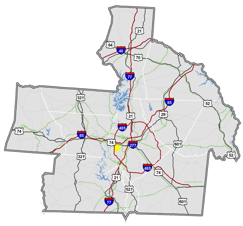
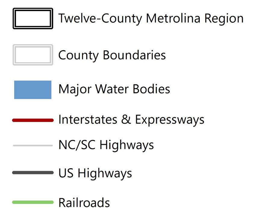
The summary of existing conditions, emerging trends and current initiatives presented in article
 three of the series is organized under seven general topics: state of the regional transportation
 system; transportation decision making in the region; others’ influence on the transportation
 system; connecting the dots with data; future transportation trend-benders; current plans, policies
 and initiatives in the region; and key takeaways for planning the region’s transportation future.

 STATE OF THE REGIONAL TRANSPORTATION SYSTEM
 The transportation system in the Metrolina Region includes highway, transit, rail, air, bicycle and
 pedestrian elements. Streets in the highway network range from two-lane, rural roads to eight-
 lane interstates, including more than 2,600 miles of interstates and federal/state highways
 running throughout the twelve-county region. Transit service in the region includes the Blue Line
 in Charlotte (light rail), the Gold Line in Charlotte (streetcar) and bus service operated by agencies
 in Charlotte, Gastonia, Concord, Kannapolis, Salisbury and Rock Hill. Railroads move freight in the
 region to points throughout the country with lines operated by Norfolk Southern, CSX and several
 short-line providers. Charlotte/Douglas International Airport is ranked among the top ten busiest
 airports in the world — averaging 1,600 daily aircraft operations — and serves over fifty million
 passengers each year who travel to one of 178 nonstop destinations
 (www.charalotteairport.com).

 Several cities and towns in the region are also
leading the way for more bicycle- and pedestrian-
friendly communities. Charlotte, Davidson and Rock
Hill are designated as bronze-level national bicycle-
friendly community award winners and Charlotte
and Davidson are designated as silver- and bronze-

  The twelve-county Metrolina Region showing interstates, highways, railroads and Charlotte Douglas International Airport

704-372-2416 | info@centralina.org | 9815 David Taylor Drive, Suite 100, Charlotte, NC 28262 | www.centralina.org
level national walk-friendly community award winners. Other initiatives in the region ― such as
the Carolina Thread Trail and the Cross Charlotte Trail ― are linking local greenways into a ‘super-
highway’ for bicycling and walking in the region.
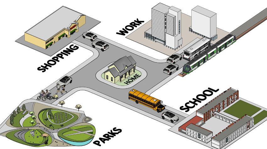
The physical distance between complementary land uses in the region — between home and
work; home and school; or home and shopping — and over-reliance on automobiles for meeting
daily travel needs in most parts of the region is leading to several unintended consequences:
rapidly increasing vehicle miles traveled and energy consumption, longer commute times,
increased air pollution and heightened infrastructure and public service costs. Inadequate long-
term transportation funding and shifts in department priorities from new construction to
maintenance for some areas worsens the problem — referred to as the growing funding gap — as
little can be done to keep up with existing and emerging region-wide decentralized growth
patterns.
The type, location,
pattern and intensity
of development in the
region influences
“demands” for the
transportation system
— including system
needs (capacity and
routes) that connect
complementary
destinations and the
viability of different
travel mode choices
available between
them.
Local, regional and state transportation officials are working toward building and safeguarding a
more sustainable transportation system as growth and development are assumed to increase and
expand significantly in future decades. Policy statements in adopted plans or projects in adopted
work programs are implementing “complete streets” concepts and “context-sensitive design”
solutions, which provide transportation choices — vehicle, transit, bicycle or pedestrian — in the
same corridor consistent with surrounding land uses and densities. Transportation officials are also
working very closely with local governments to better link transportation and land use decision-
making processes and study the opportunities and impacts associated with moving freight
through the region.
704-372-2416 | info@centralina.org | 9815 David Taylor Drive, Suite 100, Charlotte, NC 28262 | www.centralina.org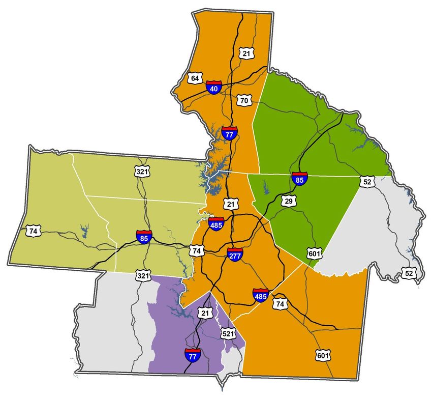
Aging infrastructure is also a major concern for transportation officials in the region, and
 maintenance needs for roads and bridges may stress already scarce transportation resources for
 new construction. Big ideas for addressing the situation are now in discussion, including
 jurisdictional responsibility for streets in the system — state, county, city or town — and alternative
 funding sources to the gas tax for keeping up with growing demands.

 TRANSPORTATION DECISION-MAKING IN THE REGION
 The responsibilities for transportation planning and decision-making in the Metrolina Region are
 shared by the North Carolina Department of Transportation (NCDOT), South Carolina Department
 of Transportation (SCDOT), four metropolitan planning organizations, two rural planning
 organizations, local governments and their partners. Plans and studies are created by these
 agencies to represent the collective interests of the region — metropolitan transportation plans,
 comprehensive transportation plans or state transportation improvement project lists — or a plan
 or study for more specific needs in a single community, corridor or intersection. All travel modes
 are considered by the agencies and organizations — air, automobile, bus, light rail, commuter rail,
 streetcar, bicycle and pedestrian — for moving people and freight in the region.

 Some transportation policies and rules are outside the influence of leaders in the region — many
 are created and funded by the federal government and implemented by state and regional
 transportation organizations — but they have significant impacts in terms of the type and quantity
 of projects that can be implemented by travel mode category.

 Consensus-building for transportation interests in the region is reached using representatives on
 policy committees, technical coordinating committees and project-specific steering committees.
 NCDOT, SCDOT and local governments interact with the four metropolitan planning organizations
 and two rural planning organizations to coordinate planning, funding, permitting and
 constructing transportation projects.

 OTHER’S INFLUENCE ON THE TRANSPORTATION SYSTEM
 Distinctly different groups in the Metrolina Region are responsible for making decisions that
 directly or indirectly impact the transportation system. Some plans, processes or procedures
 require groups to work together, while many others do not.

 LAND USE DECISIONS

 Land use planning and decision-making processes in the Metrolina Region are the responsibility
 of local governments — cities, towns and counties — that maintain a comprehensive plan, zoning
 ordinance or small area plan to guide future growth and development decisions. Plans and
 ordinances are created independent of state or regional transportation organizations. There are no
 statutory requirements for minimum content, document format, coordination procedures or
 review cycles between land use and transportation interests in the region.

704-372-2416 | info@centralina.org | 9815 David Taylor Drive, Suite 100, Charlotte, NC 28262 | www.centralina.org
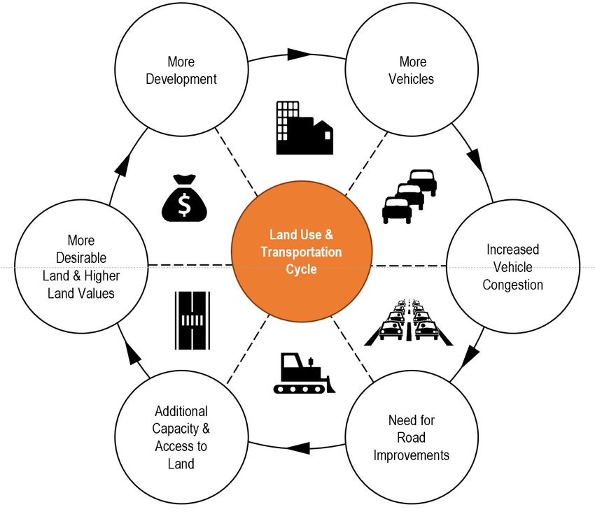
A community’s vision for land use is conveyed to transportation organizations by local government
 representation on various transportation policy committees, technical coordinating committees or
 project-specific steering committees created throughout the years. Transportation officials also
 collect land use and development data from local governments in the region once every four years
 to create socioeconomic data for the Metrolina Regional Travel Demand Model. The Model is used
 to forecast future year demand on existing and planned transportation facilities using anticipated
 land use, demographic information and travel patterns unique to the region. Approximating
 future year conditions on the transportation system helps transportation officials assess the
 implications of growth, compare alternative transportation solutions and provide a framework for
 measuring the impact of different transportation policy decisions.

   The land use-transportation cycle described above is typical of most cities, towns and counties in the Metrolina
  Region. Starting at 11 o’clock on the diagram, more development in the community generates more demands on the
  transportation system, which leads to more congestion on existing roads until such time when a road is widened to
  provide additional capacity. Additional capacity in the system or improved access to new areas in the community,
  makes the city, town or county more desirable to develop in the future. At which time, the cycle repeats itself.

704-372-2416 | info@centralina.org | 9815 David Taylor Drive, Suite 100, Charlotte, NC 28262 | www.centralina.org
EMPLOYER DECISIONS

 Employers in the region influence travel behavior since the trip between home and work (and
 back again) represents significant and repeated demand on the transportation system —
 especially during morning (7:00 to 9:00 a.m.) and evening (4:00 to 6:00 p.m.) peak periods of the
 five-day work week. Employers’ decisions about office locations and their “normal” work schedules
 directly impact travel behavior and needed improvements for the transportation system. The
 relationship between home and work locations for an employee influences the length of their trip,
 the times they travel and the mode (automobile, transit, bicycle or walking) of travel they use.

 Opinions are mixed with employers about the short-term and long-term implications of the
 COVID-19 pandemic and whether work-from-home policies in place now will generate long-
 lasting behavior changes in the future or if employees will simply return to normal experiences
 before the pandemic over some period of time. Employers are testing different rules and policies
 around telecommuting, hybrid in-person/at-home work schedules or compressed workdays for
 their employees. Programs that keep employees at home for some portion of the work week could
 help reduce traffic volumes and congestion levels during peak periods of the day. Short- and long-
 term trends in flexible work schedules will have significant impacts on the efficiency of the
 regional transportation system.

 GENERAL PUBLIC DECISIONS

 The general public also has tremendous power in changing the trajectory of transportation
 planning in future years. Their timing and willingness to make personal investments in new
 transportation technologies — connected and autonomous vehicles, shared micro-mobility
 solutions (scooters and electric bicycles), ride or vehicle share programs and web scheduling
 applications — will influence the success of private- and public-sector investments in the
 transportation system and their abilities to influence safer, more efficient and more reliable travel
 behavior. Employees also have some influence on the type and magnitude of work-from-home
 policies available in the future with their preferences for work location, flexibility and timing.
 Whether at their current employer or in seeking new employment with a business that offers
 different options and general preferences for online shopping in the future will dramatically
 redefine the purpose and needs for home to shopping trips in the region.

 CONNECTING THE DOTS WITH DATA
 Data from the U.S. Census Bureau for the twelve-county Metrolina Region was reviewed to
 document conditions and trends for the transportation system between 2010 and 2019 and
 specifically changes observed in travel behavior over the decade using three “travel-to-work” data
 categories: mode of transportation to work, travel time to work and a proxy for jobs-housing
 proximity. The three data categories combine to describe general increases or decreases in the
 decade for 1) preferences for different travel modes, 2) changing travel times between home and

704-372-2416 | info@centralina.org | 9815 David Taylor Drive, Suite 100, Charlotte, NC 28262 | www.centralina.org
work and 3) the relative distance and direction employees travel between home and work.

 Mode of Transportation to Work. A summary of “mode of transportation to work” data from the
 U.S. Census Bureau’s American Community Survey (ACS) provides a snapshot of preferences for
 different travel modes available in the region for the regular commutes between home and work.
 Five-year estimates for two periods, 2006-2010 and 2015-2019, were used to capture conditions for
 the region across six travel mode choices: automobile, drive alone; van or automobile, carpool;
 public transit; walk or bike; other means; and work-from-home. Five-year data (as opposed to one-
 year data) was used to evaluate conditions, which minimizes potential data sampling errors from
 the ACS that could skew some of the findings and trends reported.

 Regionally speaking, the overwhelming majority of employees travel to work outside the home by
 driving alone in an automobile, followed by carpooling by automobile, public transit, walking or
 biking and other means. The rank order of transportation mode used for work outside the home
 did not change over the ten-year time period. However, the share of employees working from
 home over the decade did increase from 4% to 6% as a region — an absolute change of 38,864 new
 work-from-home employees.

 County-level reporting for the ACS transportation mode to work data shows general increases in
 the share of employees working from home in Iredell, Mecklenburg, Union, Gaston, Lincoln,
 Cabarrus, Rowan, York, Lancaster and Stanly Counties. Only Cleveland and Anson Counties
 reported decreases in the share of work-from-home employees over the decade. Both
 Mecklenburg and Union Counties reported the highest capture of work-from-home employees,
 which compared favorably to carpooling as the second most popular choice for travel mode to
 work in both counties. Work-from-home employees in both counties far exceeded the number of
 transit trips recorded for work.

 Travel Time to Work. A summary of average travel time to work from the U.S. Census Bureau’s
 American Community Survey (ACS) provides a snapshot of commute times for employees that
 work outside the home. Five-year estimates for two periods, 2006-2010 and 2015-2019, were used to
 capture conditions for the region across four travel time categories: less than 15 minutes, 16 to 30
 minutes, 31 to 60 minutes and over 60 minutes. Five-year data (as opposed to one-year data) was
 used to evaluate conditions, which minimizes potential data sampling errors from the ACS that
 could skew some of the findings and trends reported.

 Regionally speaking, the number of employees reporting a commute time to work less than 30
 minutes — either less than 15 minutes or 16 to 30 minutes — decreased over the decade. The
 number of employees reporting a commute time to work more than 30 minutes — 31 to 60
 minutes or over 60 minutes — increased over the same time period. Specific reasons for the
 change in commute time to work are not provided with the data, but may include 1) increased
 congestion on the transportation system that creates travel time delays,

704-372-2416 | info@centralina.org | 9815 David Taylor Drive, Suite 100, Charlotte, NC 28262 | www.centralina.org
Percentage of Employees Reporting Travel Model to Work
                                                          Five-Year Average, 2006-2010
                                    81%
    Employees in the Region (%)

                                                11%
                                                               2%         1%         1%             4%

                                  Automobile    Carpool       Public       Walk     Other          Work-
                                  Drive-Alone                 Transit     Or Bike   Means           at-
                                                                                                   Home

                                    81% Percentage of Employees Reporting Travel Mode to Work
                                                            Five-Year Average, 2015-2019
    Employees in the Region (%)

                                                 9%                                                 6%
                                                               2%         1%         1%

                                  Automobile    Carpool       Public      Walk      Other          Work-
                                  Drive-Alone                 Transit    Or Bike    Means           at-
                                                                                                   Home
704-372-2416 | info@centralina.org | 9815 David Taylor Drive, Suite 100, Charlotte, NC 28262 | www.centralina.org
Percentage of Employees Reporting Commute Times

    Employees in the Region (%)                    Five-Year Average, 2006-2010

                                                39%
                                                             30%
                                    25%

                                                                            6%

                                    < 15        15-29        30-59          > 60

                                           Commute Time to Work (minutes)

                                       Percentage of Employees Reporting Commute Times
                                                   Five-Year Average, 2015-2019
      Employees in the Region (%)

                                                38%          33%

                                    22%

                                                                            7%

                                    < 15        15-29        30-59          > 60

                                           Commute Time to Work (minutes)

704-372-2416 | info@centralina.org | 9815 David Taylor Drive, Suite 100, Charlotte, NC 28262 | www.centralina.org
2) increased travel distance between home and work if/when employees seek affordable housing
 further away from their place of employment or 3) a change in preferred travel model to work that
 produces slower travel speeds in exchange for some other travel incentive (e.g. a shift from
 automobile to public transit that results in slower travel times but zero parking costs once the
 employee arrives at work).

 Jobs-Housing Proximity. A count of jobs by county where workers are employed from the U.S.
 Census Bureau’s On-the-Map web application provides a snapshot of the relative distance and
 direction employees travel between home and work. The most current data available for the
 Metrolina Region — 2018 data released in December 2020 — was used to quantify the number of
 employees that live and work in the same county and the relationships between multiple counties
 where employees live in one and travel to another for work.

 Regionally speaking, the number of employees that live in one county and work in another
 reached 51% in 2018. Eighteen percent of employees in the same year left the twelve-county
 Metrolina Region for work. These levels of inter-county travel in the region (and beyond) reinforces
 the need for more coordinated investments and decision-making to safeguard the regional
 transportation system.

 Six locations in the region report their highest number of employees live and work in the same
 county: Iredell, Mecklenburg, Cleveland, Rowan, York and Stanly. Six other locations report their
 highest number of employees commute outside the county where they live for work: Union (to
 Mecklenburg), Gaston (to Mecklenburg), Lincoln (to Mecklenburg), Cabarrus (to Mecklenburg),
 Lancaster (to areas outside the region) and Anson (to areas outside the region).

 FUTURE TRANSPORTATION TREND-BENDERS
 Eight new and exciting trends were identified for the region as potential game-changers, which
 may “shock the transportation system” in the future and significantly change today’s assumptions
 about travel behavior, transportation project priorities or agency decision-making processes. These
 trends include:

 Changing Preferences for Mobility Options. Mobility options for evolving transportation systems
 are increasing rapidly in response to consumer demand. More traditional modes of travel —
 private automobile, bus, light rail, bicycle or walking — are now supplemented with several other
 choices: driver/passenger ride-share vehicles, automobile share/rent collaboratives and micro-
 mobility solutions (e-scooters and e-bikes). Changes to travel mode preference, travel mode
 ownership, membership routines or travel mode storage needs will have significant impact on
 future travel behavior and specific needs to maintain a safe and reliable transportation system.

 Connected      and    Autonomous       Vehicles    (CAV).   Connected      vehicles   use    technology    to
 communicate with the driver, other vehicles or with transportation infrastructure such as traffic
 signals, signs or other items via a cloud-based network. Autonomous vehicles use sensor and

704-372-2416 | info@centralina.org | 9815 David Taylor Drive, Suite 100, Charlotte, NC 28262 | www.centralina.org
software technology to steer, accelerate and brake with no human interaction (driverless cars). The
 timeframe for full implementation of a connected and autonomous transportation system varies
 by travel mode ― primarily bus or vehicle ― and location in the world. However, most
 transportation professionals agree when it happens it could create substantial gains in volume
 capacity, travel speeds and system reliability that “change the game” for transportation planning
 in the future.

 The general partnership for comprehensive CAV solutions includes a diverse set of interests
 focused on technology, manufacturing, construction and regulation. Private sector partners
 generally include automobile and bus manufactures, vehicle-development partnerships, software
 and technology firms, broadband internet providers and insurance companies. Public sector
 partners include federal, state, regional and local transportation agencies responsible for different
 infrastructure categories: roads, interstates, bridges, traffic signals, transit and broadband internet.
 Public-private partnerships are also forming to move CAV concepts and technologies forward.

 Transit Rider Online Apps. Transit agencies throughout the United States are using online
 applications to manage ticket purchases, vehicle tracking, transfers and incident reports and to
 improve the users’ overall experience with the transit system. Sharing information with transit
 riders using web applications may increase ridership for some areas of the region if transit service
 becomes more reliable, more predictable and more convenient for future riders.

 Intelligent Transportation Systems. (ITS). ITS concepts broadly implement products and
 strategies   that   help   optimize    a   regional    transportation    system,    integrating    advanced
 communication technologies into existing or planned facilities that improve transportation safety,
 mobility and system accessibility. ITS improvements are often a cost-effective approach to
 increasing system capacity and reliability in the region and can be implemented faster and
 cheaper than most traditional road-widening improvements.

 Some investments in ITS are implementing concepts for a “next level” transportation coordination
 platform that centralizes data for transportation officials and lets them better manage movements
 of people and freight in real-time. In San Diego, their concept for a “Next OS” system will help
 create a mobility marketplace, which influences travelers’ behaviors and creates better real-time
 balance between supply and demand in the system. The digital platform will compile information
 from sources like passenger vehicles, delivery trucks, buses, e-bikes and scooters and improve how
 transportation is planned, operated and experienced in the future — sometimes varying solutions
 throughout the day based on information collected from the system (Source: San Diego Forward
 2021 Regional Plan).

704-372-2416 | info@centralina.org | 9815 David Taylor Drive, Suite 100, Charlotte, NC 28262 | www.centralina.org
Telecommuting. Telecommuting is an employment arrangement in which employees work
 outside the office one or more days of the week. Often, this means working from home or a central
 location — coffee shop, restaurant, library or somewhere else — close to home using various
 technologies to keep in touch with co-workers. Telecommuting reduces traffic volume and
 congestion on the regional transportation system during peak time periods — morning and
 evening rush hours — by removing commuters from the road (Source: Mobility Investment
 Priorities, Travel Option Strategies, Texas A&M Transportation Institute, 2020).

 Online Shopping. Online shopping generally requires less time and effort than shopping in-
 person and switches the point of sale from a store to some other location (usually home) —
 exchanging the customer trip for a product or service delivery trip on the transportation system
 that occurs several days after the purchase. Online spending represented 21.3% of total retail sales
 in 2020 with one company, Amazon, accounting for nearly one-third of all e-commerce in the
 United States (Source: Digital Commerce 360, 2021).

 Online shopping is assumed to decrease the number of total trips or length of trips on the
 transportation system by eliminating “trip chains”, which represent one trip made by a customer
 that includes multiple stops on the route — home to shop, one to shop, two to shop, three to
 home. Consolidating the trip to a single delivery vehicle often reduces the total number of trip
 destinations for a customers’ purchases — especially if the customer is shopping at a large online
 store (like Amazon) that sells many different products.

 COVID-19 Accelerators. Opinions are mixed about the short-term and long-term implications of
 the COVID-19 pandemic and whether social distancing, online shopping, work-from-home policies
 or increased personal time for some community members will generate long-lasting behavioral
 changes or if people will simply return to pre-pandemic travel within some period of time.

 Transportation planning officials in the region agree more clarity on the different topics is needed,
 and it will come over the next few years as personal and business decisions are made and more
 data becomes available. Some organizations and their partners may need to act quickly to
 reassess their vision for transportation in the future ― and revise their plans, policies or work
 programs accordingly ― once long-term impacts from the pandemic are known and accepted.

 Regional Transportation Authority. Some planning officials, who were interviewed for article two
 in the series, talked about the need for a regional transportation authority or a similar construct,
 which might partner with the four metropolitan planning organizations and their transit partners
 and coordinate major investments in a multi-jurisdictional regional highway network and a multi-
 jurisdictional regional transit network. The authority would help organize efforts in the region and
 identify local, state and federal funds available for planning, design, permitting and construction. A
 governing board would legitimize the regional transportation authority and organize its efforts in
 the area.

704-372-2416 | info@centralina.org | 9815 David Taylor Drive, Suite 100, Charlotte, NC 28262 | www.centralina.org
CURRENT PLANS, POLICIES AND INITIATIVES IN THE REGION
Transportation agencies and organizations in the region complete plans, policies and initiatives
each year that contemplate new investments for the regional transportation system and aim to
keep pace with future demands. The documents focus on improvements of all types, sizes and
locations, including intersections, blocks, corridors, local street networks, interstates, premium
transit routes, short- and long-distance bicycle or pedestrian routes, rail lines and airport facilities.
Many documents cross jurisdictional boundaries and
acknowledge the collaboration and support needed
to implement projects of regional significance.
Some important transportation plans, policies
and initiatives now underway in the region are
highlighted below. It is not an exhaustive
list but a good example of
transportation coordination
across metropolitan planning
organizations in the region.

METROPOLITAN
TRANSPORTATION PLANS
A   metropolitan          transportation        plan
(MTP)        captures             locally-adopted,
financially-constrained and long-range
visions for the regional transportation
system       and      a    list     of      projects,
partnerships and priorities needed to
implement          the       vision.        Existing
conditions are observed and future
needs anticipated, for all travel modes
served in the transportation system,
including automobile, bus, light rail,
streetcar,     commuter             rail,    bicycle,
pedestrian, freight and aviation. The
MTP is also a data source for air quality
modeling and the NCDOT or SCDOT
statewide transportation improvement
programs       that       helps      fund     major
transportation improvements in the
region.
  The twelve-county Metrolina Region showing the planning area boundaries for four metropolitan planning organizations

704-372-2416 | info@centralina.org | 9815 David Taylor Drive, Suite 100, Charlotte, NC 28262 | www.centralina.org
Four separate MTPs are maintained in the Metrolina Region. There is one for each metropolitan
 planning organization: Cabarrus-Rowan Metropolitan Planning Organization, Rock Hill-Fort Mill
 Area Transportation Study, Gaston-Cleveland-Lincoln Metropolitan Planning Organization and
 Charlotte Regional Transportation Planning Organization. Collectively, the four currently-adopted
 MTPs recommend 721 transportation projects (some big and some small) over the next 30 years for
 the region that are programmed across all the different travel modes. Shared goals across all MTPs
 generally address needs for enhanced transportation network connectivity, improved access to
 the network for different groups, increased capacity for all travel modes and reliable travel times
 for people and freight.

 CONNECT BEYOND: A REGIONAL MOBILITY INITIATIVE

 CONNECT Beyond is an initiative started in 2020 to coordinate the efforts of two states and 12
 counties in the region and define a bold, shared transit vision, which might help guide and
 coordinate individual planning efforts and capital investment projects that collectively implement
 the vision. A map of high-capacity transit corridors connecting existing and emerging growth
 centers in the region is a centerpiece of the study and provides a framework for future investment
 and decision-making. Forthcoming recommendations in the study will provide more detail on
 transit solutions and their potential to increase transportation choices, improve transportation
 equity or economic competitiveness in the region.

 The study is divided into four phases: evaluate the existing system, identify high-capacity transit
 corridors, envision a total mobility network and develop implementation strategies. The current
 phase — total mobility network — identifies a wide range of transportation solutions, including bus
 connectors, demand response van networks, bicycle and pedestrian amenities, integrated ride-
 share companies, electric scooters or other emerging technologies to advance high-capacity bus
 or rail transit initiatives. More information on the initiative is available from the project website,
 www.connect-beyond.com.

 BEYOND 77 STRATEGIC PLAN

 Beyond 77 focuses on a 68-mile stretch of Interstate 77 between Statesville, NC and Rock Hill, SC. It
 hopes to strengthen the multimodal network near the interstate and guide future mobility
 investments with new strategies, policies and programs. The study does not focus on changing
 the interstate itself and does not recommend changes to transportation projects or investments
 already underway.

 The study is divided into four phases: data collection, data analysis, project solutions and funding
 options and recommendations. The current phase — project solutions and funding options — is
 focused on identifying multimodal transportation solutions within areas three- to five-miles of the
 interstate. A solution dashboard on the Beyond 77 project website summarizes 177 ideas for
 comment, which are categorized into four general initiatives: emerging mobility technology,

704-372-2416 | info@centralina.org | 9815 David Taylor Drive, Suite 100, Charlotte, NC 28262 | www.centralina.org
programming strategy, project implementation/infrastructure solution and strategic policy.
 Comments      on    the   solution   dashboard      may    be   submitted      via   the   project   website,
 www.beyond77.com.

 CATAWBA CROSSINGS

 The Catawba Crossings study evaluates the needs (and feasibility) for building a new multi-lane
 road from southeastern Gaston County to western Mecklenburg County. The proposed project
 assumes two new bridges over the Catawba River (at Lake Wylie) and the South Fork Catawba
 River and a new interchange with Interstate 485 south of West Boulevard. The new road will
 become an important component of the regional transportation system and improve east-west
 mobility near the congested Interstate 85 and US 29-74 corridors.

 Recommendations from the study will be used for future requests to include the new road project
 in the NCDOT State Transportation Improvement Program. (Source: Catawba Crossings Fact
 Sheet).

 KEY TAKEAWAYS FOR PLANNING THE REGION’S TRANSPORTATION FUTURE
 The physical distance between complementary land uses in the region — between home and
 work, home and school or home and shopping — and over-reliance on automobiles for meeting
 daily travel needs in most parts of the region is leading to several unintended consequences:
 rapidly increasing vehicle miles traveled and energy consumption, longer commute times,
 increased air pollution and heightened infrastructure and public service costs. Inadequate long-
 term transportation funding and shifts in department priorities from new construction to
 maintenance for some areas worsens the problem — referred to as the growing funding gap — as
 little can be done to keep up with existing and emerging region-wide decentralized growth
 patterns.

 Transportation agencies and organizations in the region complete plans, policies and initiatives
 each year that contemplate new investments for the regional transportation system and aim to
 keep pace with future demands. The documents focus on improvements of all types, sizes and
 locations, including intersections, blocks, corridors, local street networks, interstates, premium
 transit routes, short- and long-distance bicycle or pedestrian routes, rail lines and airport facilities.
 Many documents cross jurisdictional boundaries and acknowledge the collaboration and support
 needed to implement projects of regional significance.

 Other groups in the region are responsible for making decisions that directly or indirectly impact
 the transportation system. Land use planning and decision-making processes are the
 responsibility of local governments — cities, towns and counties — that maintain a comprehensive
 plan, zoning ordinance or small area plan to guide future growth and development decisions.
 Their plans and ordinances generate demands for new capacity or technology in the regional
 transportation system. Employers’ decisions about office locations and their “normal” work

704-372-2416 | info@centralina.org | 9815 David Taylor Drive, Suite 100, Charlotte, NC 28262 | www.centralina.org
QUICK FACTS ABOUT THE REGION:

                                           The overwhelming majority of employees in the
                                           region travel to work outside the home by driving
                                           alone in an automobile.

                                           General increases in the share of employees
                                           working from home in Iredell, Mecklenburg, Union,
                                           Gaston, Lincoln, Cabarrus, Rowan, York, Lancaster
                                           and Stanly Counties were observed between 2010
                                           and 2019.

                                           The number of employees reporting a commute
                                           time to work less than 30 minutes decreased over
                                           the decade. The number of employees reporting a
                                           commute time to work more than 30 minutes
                                           increased over the same time period. Specific
                                           drivers for the change in commute time to work
                                           are not provided with the data, but may include 1)
                                           increased congestion on the transportation system
                                           that creates travel time delays, 2) increased travel
                                           distance between home and work if/when
                                           employees seek affordable housing further away
                                           from their place of employment or 3) a change in
                                           preferred travel mode to work that produces
                                           slower travel speeds in exchange for some other
                                           travel incentive (e.g. a shift from automobile to
                                           public transit that results in slower travel times but
                                           zero parking costs once the employee arrives at
                                           work).

704-372-2416 | info@centralina.org | 9815 David Taylor Drive, Suite 100, Charlotte, NC 28262 | www.centralina.org
schedules also directly impact travel behavior and needed improvements for the transportation
system. The relationship between home and work locations for an employee influences the length
of their trip, times they travel and mode of travel they use (automobile, transit, bicycle or walking).
The general public also has tremendous power in changing the trajectory of transportation
planning in future years. Their timing and willingness to make personal investments in new
transportation technologies — connected and autonomous vehicles, shared micro-mobility
solutions (scooters and electric bicycles), ride or vehicle share programs and web scheduling
applications — will influence the success of private- and public-sector investments in the
transportation system and their abilities to influence safer, more efficient and more reliable travel
behavior.
Looking forward, eight new and exciting trends were identified for the region as potential game-
changers, which may “shock the transportation system” in the future and significantly change
today’s assumptions about travel behavior, transportation project priorities or agency decision-
making processes:
Mobility options for evolving transportation systems are increasing rapidly in response to
1 consumer demand. More traditional modes of travel — private automobile, bus, light rail,
bicycle or walking — are now supplemented with several other choices: driver/passenger
ride-share vehicles, automobile share/rent collaboratives and micro-mobility solutions (e-
scooters and e-bikes).
Most transportation professionals agree when connected and autonomous vehicles
2 become more mainstream, it could create substantial gains in volume capacity, travel
speeds and system reliability that “change the game” for transportation planning in the
future.
Sharing information with transit riders using web applications may increase ridership for
3 some areas of the region if transit service becomes more reliable, more predictable and
more convenient for future riders.
ITS improvements are often a cost-effective approach to increasing system capacity and
4 reliability in the region and can be implemented faster and cheaper than most
traditional road-widening improvements.
704-372-2416 | info@centralina.org | 9815 David Taylor Drive, Suite 100, Charlotte, NC 28262 | www.centralina.orgTelecommuting reduces traffic volume and congestion on the regional transportation
5 system during peak time periods — morning and evening rush hours — by removing
commuters from the road (Source: Mobility Investment Priorities, Travel Option
Strategies, Texas A&M Transportation Institute, 2020).
Online shopping is assumed to lower the number of total trips or length of trips on the
6 transportation system by eliminating “trip chains”, which represent one trip made by a
customer that includes multiple stops on the route — home to shop, one to shop, two to
shop, three to home. Consolidating the trip to a single delivery vehicle often reduces the
total number of trip destinations for a customers’ purchases — especially if the customer
is shopping at a large online store (like Amazon) that sells many different products.
Opinions are mixed about the short-term and long-term implications of the COVID-19
pandemic and whether social distancing, online shopping, work-from-home policies or
7 increased personal time for some people in the community will generate long-lasting
behavior changes, or if people will simply return to pre-pandemic travel behavior over
some period of time.
Some planning officials, interviewed for article two in the series, talked about the need
for a regional transportation authority or a similar construct, which might partner with
8 the four metropolitan planning organizations and their transit partners and coordinate
major investments in a multi-jurisdictional regional highway network and a multi-
jurisdictional regional transit network.
It will be exciting to complete research and interview transportation thought leaders in the U.S. for
Part 2 of the transportation assessment in July. The information collected and the experiences
shared, will help transportation officials in the region look forward to opportunities and challenges
facing the area now or in the future — especially as communities come together with increasing
interests to implement a shared vision for the regional transportation system.
704-372-2416 | info@centralina.org | 9815 David Taylor Drive, Suite 100, Charlotte, NC 28262 | www.centralina.orgMORE ARTICLES TO COME We will continue to inventory and evaluate accomplishments in the region that tie back to CONNECT Our Future and highlight specific data and stories that may inform new actions or priorities for Centralina staff as they continue to support local initiatives that implement the region’s priorities. The article in July will continue the focus on transportation, including opportunities and challenges facing the region now or in the future as communities come together with increasing interests to implement a shared vision for the regional transportation system. This information will be combined with future articles to compile a comprehensive report at the end of the project and a dashboard with benchmarks identified to measure and track regional progress towards CONNECT Our Future goals. Stay tuned. We look forward to reflecting on the CONNECT Our Future initiative, the influences it had on the region and sharing those stories with you to reinforce the benefits of thinking regionally and acting locally. 704-372-2416 | info@centralina.org | 9815 David Taylor Drive, Suite 100, Charlotte, NC 28262 | www.centralina.org
You can also read