CSIRO Vegetation Assessment and Monitoring Initiative - Earth Observation Centre Canberra
←
→
Page content transcription
If your browser does not render page correctly, please read the page content below
CSIRO Vegetation Assessment and
     Monitoring Initiative

        Earth Observation Centre
               Canberra
• The purpose of this document is to inform the
  interested reader about a new CSIRO Initiative
  in Vegetation Assessment and Monitoring

• It does this by outlining
      – Situation and Needs analyses
      – CSIRO research response
      – Time lines of products and applications

• Though principally designed to share
  information, this document also solicits and
  directs feedback from readers seeking active
  engagement with the Initiative

  Earth Observation Centre                         2
• A Situation Analysis of the very broad and expanding
  area of Environmental Management reveals two clear
  signals
      – Within Australian society, Landscape
          Rehabilitation, Agricultural and Ecological
          Sustainability, Greenhouse and Biodiversity are
          issues which enjoy a high and persistent level of
          political interest
      – This interest translates to a high level of
          expectation by Australian society that
          environmental management agencies, Public
          and Private, will ‘get it right’

• That is, Australian society expects Public and Private
  sector Environmental Management to be responsive and
  comprehensive

   Earth Observation Centre                                   3
• However, it is now clear that the rate limiting
  step in improving management is the supply
  of relevant, revealing and timely data

• This escalating data demand has three
  sources:
     – Informing Policy & Strategic
        development
     – Providing Feedback to management
     – Demonstrating Compliance

• To meet these data demands, there is a
  present and growing future need for enhanced
  capacity in assessing and monitoring
  environmental variables which are relevant to
  management
  Earth Observation Centre                          4
• Within the issues of Sustainability,
  Greenhouse and Biodiversity - grouped as
  ‘Condition of the Environment’ - many of the
  required environmental measures (or indices)
  relate to vegetation structure and its dynamics
  on landscape scales

• This interrelation is fundamental because
     – Vegetation is the primary trophic level.
     – Structure represents the cumulative
        response of vegetation to climate,
        competition, use and/or disturbance.
     – Change in structure is accompanied by
        change in landscape functioning.
  Earth Observation Centre                          5
• Measurements of vegetation type (growth
  form) and canopy structure (height, density,
  vertical & horizontal biomass, gappiness, etc.)
  form the basis of assessing landscape
  condition under all landuse regimes, incl.
     – Forestry
     – Conservation

• Similarly, measurements (and interpretation)
  of structural change provide critical feedback
  for management of aggrading or degrading
  trends
      – Distribution and intensity of use
      – Remediation
      – Rehabilitation

  Earth Observation Centre                          6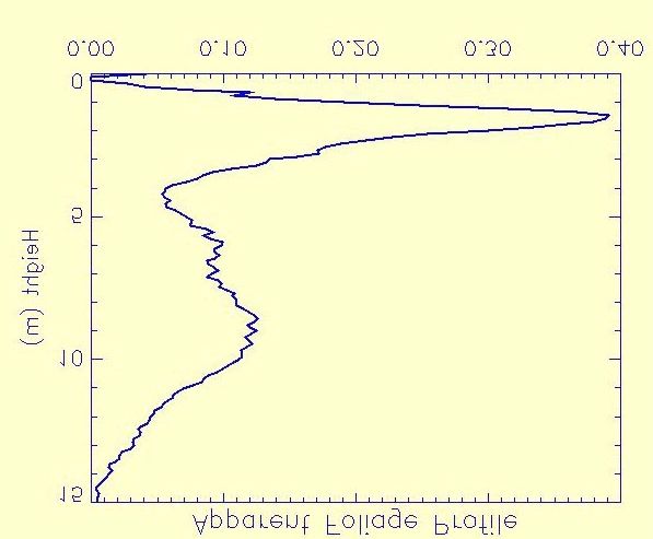
• We conclude that a current and foreseeable need
  in many areas of Environmental Management
  is an enhanced capacity for assessing and
  monitoring (vegetation) canopy structural
  variables (eg):
      – Tree heights, sizes and shapes
      – Vertical and horizontal foliage density
      – Cover & Gap by layer and Type
• Deciding on what would be the most effective
  and pervasive enhancement of measurement
  capacity, as well as undertaking the required
  research and development to achieve and
  demonstrate it, comprises the CSIRO Initiative
  in Vegetation Assessment and Monitoring

  Earth Observation Centre                          7
• First: five prerequisites for enhanced canopy
measurement capacity
– 1) Objective measurement
Machine acquisition of the primary data
– 2) High signal to noise ratio
Minimise the uncertainty associated with the
primary data and all derived (secondary) outputs
– 3) Flexible sampling in space and time
Operation at local to global scales
Integration with other data types to multiply
utility
Task-specific sampling options to minimise costs
Multi-stage sampling capability to maximise
certainty
Earth Observation Centre 8– 4) High inherent accuracy (assessment)
and precision (monitoring)
For maximum credibility, the same data type
should be used for assessment and for monitoring
(change detection)
– 5) Robust and Transparent modelling
between measured variables (primary
data) and required (derived) attributes
Scaffolding: By designing the measurement
system to closely match existing methodologies,
the (considerable) volume of current
understanding, eg. forest mensuration, can be
assimilated into the analysis techniques
Compliance: Verification and accreditation
requires transparency in derivation of outputs
Earth Observation Centre 9• Prerequisites 1-4 dictate remote sensing, while
5 narrows the choice of technology to LIDAR
• Other technologies, such as Hyperspectral
and Synthetic Aperture Radar (SAR), have
disqualifying limitations
– Complex relationships between
structure and data
– High expense in instrumentation,
acquisition and processing
– Links to standard structural
measurements not established
Earth Observation Centre 10• The CSIRO Earth Observation Centre (EOC)
is coordinating CSIRO’s Canopy LIDAR R&D
strategy
• Over the next 3 years (2000 - 2003) there will
be a concerted effort involving scientists from
a number of CSIRO Divisions and Research
and Commercial Partners
• This R&D effort will be directed into
– Designing enhanced instrumentation
– Refining (CSIRO) analysis methodology
• The R&D strategy follows three concurrent
paths
Earth Observation Centre 11• Path 1: Refine (CSIRO) methodology for
extracting relevant canopy variables using
existing LIDAR datasets
– This initial research has used data from
a NASA research LIDAR instrument
(SLICER)
– These data, acquired in 1996, are
available for largely coniferous forest
canopies
– Nonetheless, this first test of CSIRO
research has yielded clearly applicable
results (eg over the page & at our Web
Site)
– Research within NASA continues to
confirm the utility of canopy LIDAR
Earth Observation Centre 12CSIRO algorithms used on NASA SLICER
data can accurately retrieve the
vertical distribution of foliage
(incl. branch) density throughout the
depth of the canopy and thereby
discriminate the (coniferous) tree
layer (5-15m) from the shrubby
understorey (< 5m). Such a profile
of foliage distribution, objectively
measured and transparently derived,
provides a fundamental and thus
powerful description of vegetation in
both space and time.
Earth Observation Centre 13• Path 2: Apply and Validate CSIRO methodology using
data from the (space-borne) NASA Vegetation Canopy
Lidar (VCL) instrument
– The VCL instrument is scheduled for launch in
September 2000
See http://essp.gsfc.nasa.gov/vcl/
– CSIRO is currently negotiating details of data
access and a continental network of effective
validation sites and supporting measurements
– Product will be a contemporary, continent-wide
description of vegetation structure
Canopy life form, cover, LAI, biomass, etc.
Integrated with existing satellite data (AVHRR, MODIS,
SPOT, SPOT VEGETATION & LANDSAT)
Anticipate completion mid-2003
Earth Observation Centre 14• Path 3: With a commercial partner, design and
build an airborne Vegetation LIDAR for
commercial operation within Australia and
elsewhere
– In progress, first steps
Current anticipated completion date is mid 2002
– Device will include both LIDAR and
imaging components and be known as
the Vegetation Structural Imaging System
(VSIS)
– Targeted applications include
Commercial forestry (inventory, monitoring)
Carbon trading (verification of ‘Kyoto Forests’)
Conservation land use (habitat mapping,
monitoring) & Land rehabilitation
Agri-pastoral land use (assessment, monitoring)
Earth Observation Centre 15• Path 3 (continued): With a commercial
partner, design and build a portable ground
based LIDAR for scientific and commercial
purposes within Australia and elsewhere
– In progress, first steps
Current anticipated completion date is 2001
– Device will be a portable LIDAR and is
known as the ECHIDNA project
– The ECHIDNA instrument will provide
unique stand alone descriptions of
canopy structure as well as serving to
help interpret airborne or spaceborne
LIDAR data.
Earth Observation Centre 16dP (r )
• Path 3 (continued): To facilitate the S! (r ) = −C! ρ v gap
dr
interpretation and use of canopy descriptions H! (r ) = S! (r ′) dr ′
∫0
r
provided by both VSIS and ECHIDNA lidars, = C! ρ v (1 − Pgap (r ))
S! (h) = C! ρ P (h)
advanced software for interpretations of g gap
ρg !
forest structures and 3D Visualisation = C! ρ g −
ρv
H ( h)
techniques will be developed.
• The forest description provided by ECHIDNA
and VSIS will match but advance those that
foresters and ecologists have been struggling
to map and scale from field sites for many
years.
Earth Observation Centre 17• Summary: CSIRO has analysed current and
foreseeable data needs in renewable resource
management
– The capacity to assess and monitor
vegetation canopy structure is a
requirement common to current and
foreseeable environmental management
issues
• CSIRO has looked hard at the future and
resolved that the best option is Vegetation
LIDAR
• CSIRO is now working to realise this future
with Research and Commercial Partners
Earth Observation Centre 18• Feedback & Contact:
• Comments and expressions of interest are
welcome
• Please direct them to:
Dr David Jupp
Director, COSSA / EOC
Phone: (02) 6216, 7203
Email: david.jupp@eoc.csiro.au
Earth Observation Centre 19You can also read