SATELLITE LASER RANGING AND EARTH SCIENCE - NASA SPACE GEODESY PROGRAM
←
→
Page content transcription
If your browser does not render page correctly, please read the page content below
SATELLITE LASER RANGING AND
       EARTH SCIENCE

      Current constellation of satellites supported by SLR

    NASA SPACE GEODESY PROGRAM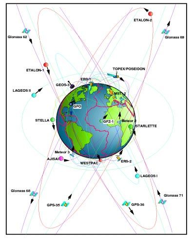
SATELLITE LASER RANGING
In Satellite Laser Ranging (SLR) a global network of stations measure
the instantaneous round trip time of flight of ultrashort pulses of light to
satellites equipped with special reflectors. This provides instantaneous
range measurements of millimeter level precision which can be
accumulated to provide accurate orbits and a host of important science
products.

 • Satellite Laser Ranging is a proven geodetic technique with significant potential for
     important contributions to scientific studies of the Earth/Atmosphere/Oceans system.

 • SLR is the most accurate technique currently available to determine the geocentric position
     of an Earth satellite, allowing for the precise calibration of radar altimeters and separation
     of long-term instrumentation drift from secular changes in ocean topography.

 • SLR’s ability to measure the temporal variations in the Earth’s gravity field and to monitor
     motion of the station network with respect to the geocenter, together with the capability to
     monitor vertical motion in an absolute system, makes it unique for modeling and evaluating
     long-term climate change by:

       Ø Providing a reference system for post-glacial rebound, sea level and ice volume
         change

       Ø Determining the temporal mass redistribution of the solid Earth, ocean, and
         atmosphere system

       Ø Monitoring the response of the atmosphere to seasonal variations in solar heating.

  • SLR provides a unique capability for verification of the predictions of the Theory of
      General Relativity.

  • SLR stations form an important part of the international network of space geodetic
      observatories, which include VLBI, GPS, DORIS and PRARE systems.

  • On several critical missions, SLR has provided failsafe redundancy when other
      radiometric tracking systems have failed.

  • The cost effectiveness of SLR operations are improving through increased standardization,
      configuration control, and automation. NASA is vigorously pursuing the development of
      SLR 2000, a stand-alone, low-cost, subcentimeter SLR system.

  • The International Laser Ranging Service has been formed by the global SLR community
      to enhance geophysical and geodetic research activities (ilrs.gsfc.nasa.gov).
SLR CONTRIBUTION TO EARTH SCIENCE

        Laser ranging to a near-Earth
     satellite was initiated by NASA
       in 1964 with the launch of the
        Beacon-B satellite. Since that
     time, ranging precision, spurred
       by scientific requirements, has
            improved by a factor of a
    thousand from a few meters to a
                      few millimeters.

During the past three decades, the global Satellite Laser Ranging (SLR) network has evolved
into a powerful source of data for studies of the solid Earth and its ocean and atmospheric
systems. In addition, SLR provides precise orbit determination for spaceborne radar altimeter
missions mapping the ocean surface (which are used to model global ocean circulation), for
mapping volumetric changes in continental ice masses, and for land topography. It provides a
means for subnanosecond global time transfer, and a basis for special tests of the Theory of
General Relativity.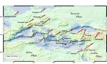
SLR SUPPORTS THE STUDY OF THE
ATMOSPHERE-HYDROSPHERE-CRYOSPHERE-
SOLID EARTH SYSTEM
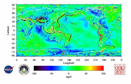
Twenty-five years of SLR data has provided the standard, highly accurate, long wavelength
gravity field reference model which supports all precision orbit determination and provides the
basis for studying temporal gravitational variations due to mass redistribution. The height of the
geoid has been determined to less than ten centimeters at long wavelengths less than 1500 km.
Thirty-second mean gravity anomalies from the EGM96 model show the fine detail.
From temporal changes in
the gravity field, SLR
measures the effects of mass
redistribution in the total
Earth system. A decade of
SLR-determined monthly
values of the second zonal
harmonic of the Earth’s
gravity provide independent
verification of the mass
redistribution implied by
global atmospheric
circulation models used to
.
predict global climate
change.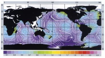
SLR SUPPORTS
   DIRECT SENSING OF SURFACE ELEVATIONS

 SLR provides direct, unambiguous
  measurement of altimeter satellite
        height and permits effective
 separation of altimeter system drift
from long-period ocean topography
   changes at the sub-cm level. This
      calibration is essential for the
   measurement of global mean sea
  level changes of a few mm/yr and
the mapping of ice field topography
         used to estimate ice volume
                            changes.

                                         Satellite altimeters
                                         were used to
                                         compute the
                                         cotidal map of the
                                         main lunar M2
                                         tide.
                                         Understanding the
                                         nature of tidal
                                         dissipation and
                                         ocean bottom
                                         friction requires a
                                         more detailed
                                         knowledge of
                                         ocean tides. Better
                                         tide models are
                                         also required to
                                         support ocean tidal
                                         loading models
                                         needed to analyze
                                         precise gravimetry.
SLR CONTRIBUTES TO SEA AND ICE LEVEL
               MONITORING
 SLR contributes to the monitoring
    of sea level change in two ways.
First, by supplying tracking data for
   orbit determination, SLR assures
  excellent radial orbital knowledge
   of altimeter satellites. Second, by
   improving knowledge of mm/yr-
 level secular changes in the height
      of coastal observing sites, SLR
 helps to resolve ambiguities in the
     tide gauge record. Variations in
                 mean sea level from
TOPEX/Poseidon match sea surface
  temperature measurements which
          indicate El Nino- Southern
                   Oscillation events.

                                         The topography
                                         (and its changes)
                                         of the EarthÕs ice
                                         sheets are mapped
                                         using satellite
                                         altimeters and
                                         precision orbits
                                         based on SLR and
                                         SLR-based force
                                         models.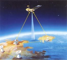
SLR Measures the Long Term Dynamics of
 the Solid Earth, Oceans and Atmosphere

 SLR determinations
        of the Earth’s
         rotation and
   orientation reveal
       changes in the
 distribution of mass
     and exchange of
 angular momentum
        in total Earth
              system.

                            SLR determination of the
                            changes in the geocentric
                            height of stations coupled
                            with determination of the
                            motion of the station
                            network with respect to
                            the geocenter at the few
                            mm level provides a
                            reference for studies of
                            sea level variations and
                            post-glacial rebound. The
                            apparent changes in the
                            X and Y components of
                            the geocenter can be
                            monitored at the
                            millimeter level.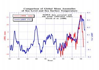
SLR SUPPORTS STUDY OF TECTONIC MOTION
SLR provides mm/yr accurate determinations of station motion on a global scale in a geocentric
reference frame. Combined with gravity models and decadal changes in Earth rotation, these
results contribute to modeling of convection in the Earth’s mantle by providing constraints on
related Earth interior processes. The velocity of the fiducial station in Hawaii is 70 mm./year and
closely matches the rate of the background geophysical model.

   The horizontal
motion of a global
 network of SLR
       sites in the
Mediterranean has
      shed critical
  insight into the
         nature of
    contemporary
  plate tectonics.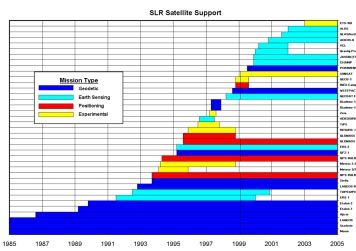
SLR SUPPORTS RESEARCH IN
                  FUNDAMENTAL PHYSICS

     LLR tracking of corner cube retroreflectors on the
moon has verified the Equivalence Principle of General
 Relativity. SLR measurements LAGEOS 1 and 2 have
  measured the Lense-Thirring “drag” of the reference
       frame. A third LAGEOS-type satellite has been
                        proposed for relativity studies.

                                                           SLR measurements of
                                                           Lageos have provided the
                                                           most accurate
                                                           measurement of GM, the
                                                           product of the
                                                           gravitational constant and
                                                           the mass of the Earth, and
                                                           have confirmed that it
                                                           does not change secularly.

   The speeds between SLR stations
   on stable plate interiors helped to
    support the tectonic plate model
   based on a revised paleomagnetic
                           time scale.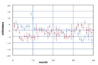
SLR OPERATIONS ARE STEADILY IMPROVING

SLR data yield has improved
through:

• Real-time data processing,
• Satellite pass interleaving,

• System upgrades,

• Additional operating, and

• Additional Satellites.

                                 The Crustal Dynamics Data
                                 Information System (CDDIS), located
                                 at NASA GSFC, is the main
                                 repository for the global space
                                 geodesy data set, which is also
                                 available from the European Data
                                 Center in Germany. The SLR data are
                                 provided via electronic access and/or
                                 magnetic tape.
SLR TECHNOLOGY IS RAPIDLY ADVANCING
Mission support by
the SLR Network has
expanded
dramatically in recent
years, and the need
for SLR will continue
to grow in the future.
A variety of geodetic
and geodynamic
missions are planned,
as well as
applications in Earth
sensing and satellite
positioning.
NASA's next generation
SLR station, currently under
development, is fully
automated, unmanned,
inherently eyesafe, and will
operate 24 hours a day to
the full suite of artificial
satellites. The SLR2000
design is expected to greatly
reduce station construction,
operating and engineering
maintenance costs. The low
energy, high repetition rate,
photon counting approach
represents a quantum
technological leap over
prior low repetition rate,
high signal-to-noise ratio
designs.You can also read