CUB CREEK 2 BURNED AREA SUMMARY - 2500-8 BURNED AREA REPORT - INCIWEB
←
→
Page content transcription
If your browser does not render page correctly, please read the page content below
Okanogan-Wenatchee National Forest | September 2021
Cub Creek 2 Burned Area Summary
2500-8 Burned Area Report
Fire Background Watershed Response
The Cub Creek 2 Fire started on July 16, 2021,
Soils
from a lightning strike. The fire burned through dry
brush and timber north of Winthrop, WA. This Soils within the burned area are formed in
~71,000-acre fire caused evacuations and multiple materials comprised primarily of glacial till, glacial
closures remain in place due to the fire effects. The outwash, alluvium, colluvium, and residuum from
fire burned almost entirely within the Chewuch various rock sources. The soils vary widely in
River drainage. texture, depth, content of rock fragments, drainage,
and temperature. Most of the soils are blanketed
with a mantle of volcanic ash of varying thickness.
Soils throughout the burned area generally shows
weak development since most are derived from
glacial materials. Additionally, alluvial and
colluvial processes have retarded soil forming
processes and the development of strong soil
structure.
An estimated 41% of the burned area within the
Cub Creek 2 Fire had high or moderate soil burn
Figure 1 Plume on the Cub Creek 2 Fire
severity and may have developed water repellent
soils as a result. Vegetation mortality in the
The Forest Service assembled a Burned Area
moderate and high soil burn severity areas ranged
Emergency Response (BAER) team on August 25,
from 80 – 100% (see map on page 6).
2021. This team of experts in various natural
resource disciplines began assessing the post-fire Geology
effects to critical values on Forest Service lands. Much of the Pacific Northwest is very
The team developed a soil burn severity (SBS) map geologically active and many steep slopes are prone
to document the degree to which soil properties had to landslides and debris flows as a natural process.
changed within the burned area. Fire-damaged soils The Cub Creek 2 Fire may speed up some of those
have low strength, high root mortality, and exhibit natural processes in certain watersheds. Fire
increased rates of water runoff and erosion. Using increases the potential for debris flows, partly due
the SBS map, BAER team members ran models to to the removal of vegetation.
estimate changes in stream flows (hydrology) and The USGS-derived models estimate a moderate
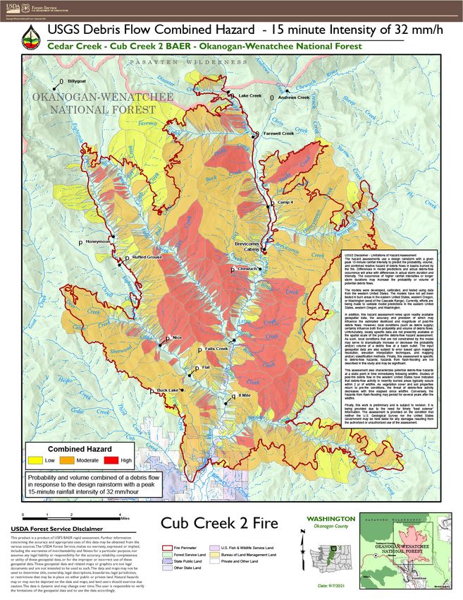
debris flow (geology) potential. The modeled to high level of debris-flow hazard for most of the
results were then used to determine the relative risk area burned by the Cub Creek 2 fire. Many stream
to different critical values and inform reaches and drainages have a greater than 40%
recommendations to address risks that were likelihood of debris flow occurrence at the modeled
determined to be an emergency. This document acts rainfall intensity. Many of the basins and stream
as a summary of the formal assessment and FS- reaches near the center of the burn area have a high
2500-8, Burned Area Report. (60-80%) to very high (>80%) likelihood of debris-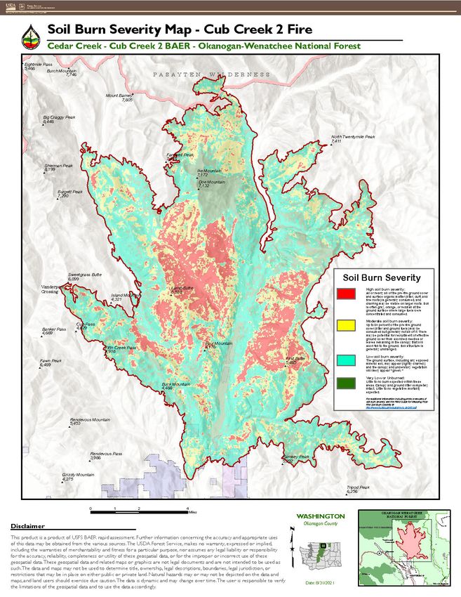
flow occurrence. These high hazard areas mostly                          metamorphic residuum as elevation increases.
occur in drainages above Doe Creek, Falls Creek,                         Slopes range from moderately steep to very steep
Eight Mile Creek, and the Chewuch River (see map                         throughout the Cub Creek 2 Fire and corresponding
on page 7).                                                              drainages.
Hydrology                                                                    Potential critical values at risk addressed in this
         Preliminary hydrologic modeling predicts a                      report include Forest Service System Roads and
substantial increase in runoff over much of the                          related drainage features.
burned area. Flood flows in smaller drainages                                Roads at risk include 5010100, 5010500, 37,
resulting from the 5-yr 1-hour rainstorm (20%                            3700825, 5130, 5130100, 5130300, 5130382, 5140,
probability of occurrence in the first year following                    5140030, 4140280, and 5140300; also, all non-
the fire, about 50% probability in years 1-3) are                        surveyed roads within or immediately adjacent to
predicted to increase 50 to 200-fold over pre-fire                       high or moderate soil burn severity.
flow levels (see map on page 8).
Critical Values
Roads and Bridges
    The watersheds burned in the Cub Creek 2 Fire
are predicted to exhibit varying degrees of response
through increased runoff, and debris and sediment
transport. This creates a future concern for roads
(figure 2), culverts (figure 3), bridges, and channels
along the drainage paths of the burned watersheds
in that they may be plugged, overtopped, or washed
away more frequently than experienced under pre-
fire conditions.

                                                                         Figure 3 Plugged culverts can lead to a road being overtopped by flood
                                                                         waters.

                                                                             The proposed treatments include signs warning
                                                                         travelers of the increased danger, temporary
                                                                         closures of roads where safety is at particularly high
Figure 2 Hazard trees pose a recurring threat during and after a fire.   risk, post-storm inspection, drainage dips, clean
                                                                         ditches and inlets to handle increased flows, and
    Forest system roads within the burn perimeter                        fixing burned holes in the road prism.
(325 miles) or connected to it are located on soils                          Bridges at risk include the Falls Creek Bridge,
derived from alpine glacial till at lower elevations                     Falls Creek Utilities Bridge, and Eightmile Creek
or volcanic ash and pumice over igneous or                               #1 Bridge.
                                                                                                                                             2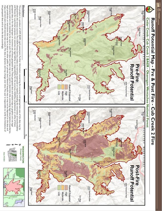
The proposed treatment is regular post-storm
inspections to clean out drainages and any
accumulated debris.
Recreation
     Many recreation resources are located within or
near the perimeter of the fire on NFS lands,
including eight campgrounds (figure 4), five
trailheads, numerous dispersed use sites, seven terra
trails, one sno-park, groomed motorized trails, and
two rivers eligible for Wild & Scenic River
designation. Recreational use occurs throughout the
year within this area and seasonal use occurs at each
of the developed infrastructure assets.                 Figure 4 Burned sign at the Nice Campground
   Camping: Both campers and infrastructure at
Falls Creek, Chewuch, Camp 4, Buck Lake, and                Dispersed camping is a popular activity in this
Nice campgrounds are at high risk due to the threat     area as well. While no infrastructure is at risk in
of increased flooding and debris flow. These            these aeras, human life and safety is still a major
campgrounds are located on alluvial fans from           concern at many of these sites, due to falling trees
previous debris flow events. Geologists found           and flooding. The forest recommends temporarily
evidence of debris flows in the not-too-distant past.   closing either the dispersed camping or the road
Based on the combined evidence of the USGS              corridor between specific points. These roads are
debris flow analysis, site assessments, and             discussed in the engineering analysis performed by
preliminary post-fire flow modeling by the BAER         the BAER team.
team, these sites were judged to be at varying              Trailheads and Trails: People using the Falls
degrees of risk of inundation. This risk is             Creek trailhead (518) are threatened by hazard trees
compounded at campgrounds, where people stay            that are a high risk to human life and safety. The
overnight and may not be able to respond to rapid       recommended treatment is temporary closure,
events such as flash floods or debris flows.            installation of warning signs, hazard tree assessment
    The recommended treatment includes temporary        and removal. The Eightmile Ridge trailhead (523)
campground closure, physical closure with gates,        has not been assessed for hazard trees due to the
and warning signs. To prevent damage to                 road to the trailhead being blocked by fallen trees.
campground water supply wells at Falls Creek and        Hazard tree assessment should be completed at the
Chewuch campgrounds, pump jacks should be               trailhead when access is possible. Based on the
removed and well heads capped. Portable site            assessment, treatments could include temporary
infrastructure, such as picnic tables, could be         closure and hazard tree removal.
removed and stored outside of the flood plain at            The Falls Creek Falls trail (518.1) is an ADA-
each campground recommended for closure.                accessible, highly developed trail located adjacent
                                                        to Falls Creek, which is at high risk for increased
                                                        flooding and debris flows. Much of the area
                                                        surrounding the trail is burned and hazard trees are
                                                        present. Due to the high use level of this trail, its
                                                        status as ADA accessible with atypical use patterns,
                                                        and proximity to Falls Creek, recommended
                                                                                                               3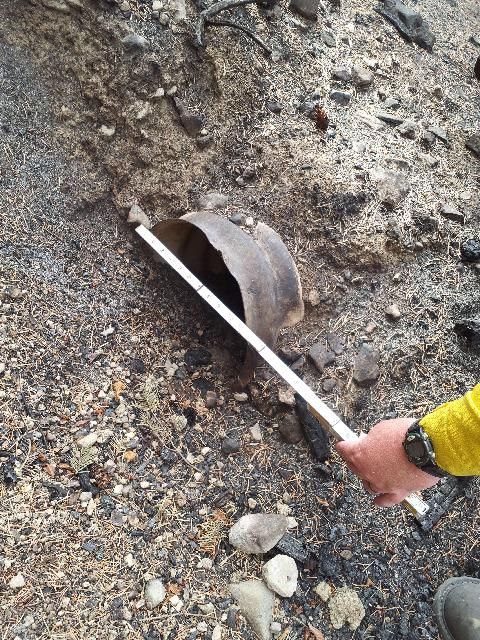
treatment is to temporarily close the trail, post         forest plant communities slow to recover from
warning signs, and conduct hazard tree assessment         repeated wildfires or whose ecological functions
and removal as needed. These treatments address           and fire resiliency have been altered due to
threats to the critical value of human life and safety.   currently present weedy and invasive species.
    For all other trails in the burned area, the          Forty-four percent of riparian habitat mapped in the
recommended treatment is for warning signs to be          burn area was potentially impacted by high to
posted at all trailheads. Except for the Falls Creek      moderate severity fire effects. If weed infestations
Falls trail and Buck Mountain trail, most trails have     are not detected and controlled within the first year
not had recent or consistent maintenance, resulting       post-fire, these previously intact native communities
in the trails being in degraded condition prior to the    will likely type-convert into exotic species
fire. Emergency treatment to stabilize the trail prism    dominance.
from further damage is unlikely to be effective due
to the condition of the trails.
    There are six groomed winter motorized trail
routes within the burned area, but only the
Eightmile Road (5130) is recommended for
temporary closure due to the amount of the route
that travels through high and moderate burn severity
areas.
Botany
    The Cub Creek 2 fire burned into fire-sensitive
riparian and shrub-steppe communities and
reburned patches of forests and woodlands
recovering from recent severe fire effects. The
unknowing introduction and dispersal of invasive
weeds into areas disturbed by fire suppression and
rehabilitation has the potential to establish large and
persistent weed populations. In addition, it is highly
likely that extant weed infestations adjacent to the
burn area will expand due to their accelerated
growth and reproduction and a release from
competition with natives.
    Approximately 38 miles of dozer line (figure 5)
                                                          Figure 5 Dozer lines are hot spots for noxious weed infestations after
and 12 miles of handline were constructed outside         fire.
and within the burn perimeter. In addition to
causing an increase in weed invasion, the                     The Forest recommends a treatment of Early
disturbances caused by dozer lines are expected to        Detection, Rapid Response (EDRR) to monitor for
create accelerated erosion and soil compaction that       noxious weed infestation and expansion. In areas
may also inhibit the recovery of native plant             disturbed due to mechanical suppression activity
populations. Approximately 25,886 acres (35%) of          (approximately 360 acres) and burned areas prone
the Cub Creek 2 fire overlapped with seven                to new noxious weed infestations (240 acres), weed
different fires that have occurred on USFS land           technicians will perform regular surveys and treat
within the past 35 years, including 15,137 acres of       new infestations.
                                                                                                                                   4
Cultural Resources                                                           boundaries, additional threats exist for assets not
     There are approximately 7 historically                                  owned or managed by the Forest Service. This
significant sites within the Cub Creek 2 burned area                         includes recreation residences, private property,
and assessments of those sites is planned. While the                         municipal water sources, etc., and the BAER team
initial focus of the BAER team was human life and                            is already engaged with interagency partners to
safety, the team also recognizes that heritage                               ensure that off-Forest values covered by other
resources are critical values. These significant sites                       programs are addressed by the relevant responsible
will be evaluated as soon as possible by district staff                      entities.
to assess fire damage and new risks from the post-
                                                                             Conclusion
fire conditions.
                                                                                 The BAER team has identified imminent threats
Wildlife                                                                     to values at risk based on a rapid scientific and
    Impacts to aquatic systems are directly related                          engineering assessment of the area burned by the
to the anticipated increases to runoff, erosion, and                         Cub Creek 2 Fire. Despite taking significant
sedimentation in streams. Proposed treatments for                            precautions to minimize exposure to COVID-19,
road drainage will help to reduce those impacts to                           the assessment was conducted using the best
stream habitats. District fish biologists are                                available methods to analyze the potential for
reviewing the assessment and preparing emergency                             flooding and debris flows. The findings provide the
consultation documentation and coordinating with                             information needed to prepare and protect against
aquatic habitat restoration partners.                                        post-fire threats. The Forest Service will continue to
Non-Forest Service Values                                                    provide information and participate in interagency
   Since fire effects know no administrative                                 efforts to address threats to public and private
                                                                             values at risk resulting from the Cub Creek 2 Fire.

                Figure 6 This dispersed campsite was heavily burned and poses substantial risks to potential overnight visitors.

                                                                                                                                   5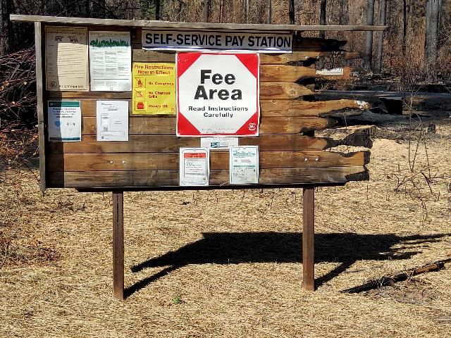
Figure 7 Soil burn severity map of the Cub Creek 2 Fire.
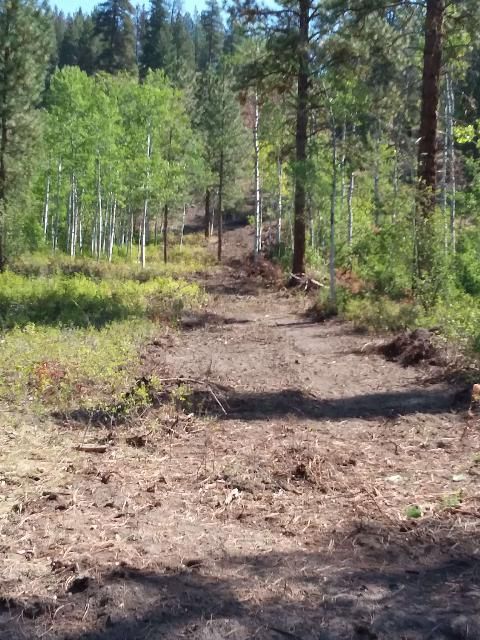
Figure 8 Debris flow hazards for the Cub Creek 2 Fire
                                                        7
Figure 9 Maps showing pre- and post-fire modeled runoff potential.
                                                                     8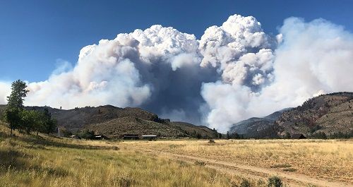
You can also read