CzechGeo/EPOS EPOS ERIC - national node of ESFRI Landmark Pavel Hejda
←
→
Page content transcription
If your browser does not render page correctly, please read the page content below
CzechGeo/EPOS
national node of ESFRI Landmark
           EPOS ERIC

         Pavel Hejda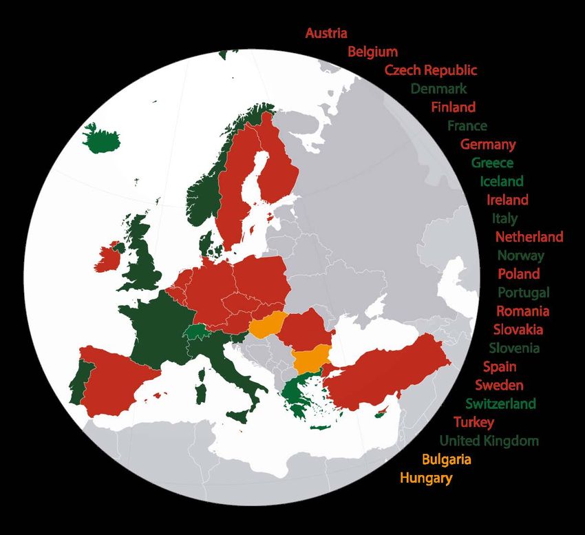
Large Research Infrastructures – Europe
• In 2002 ESFRI (European Strategy Forum on Research
  Infrastructures) was established bringing together the EU
  Member States and defining the priorities for developing
  excellent research infrastructures of pan-European character
  and impact.
• EPOS (European Plate Observing System) was included into

                                                                            LRI and Related Projects
                                                                     CzechGeo/EPOS Workshop 2017
  the ESFRI Roadmap in 2008.
• EPOS mission is to integrate the diverse and advanced
  European Research Infrastructures for solid Earth science, and
  build on new e-science opportunities to provide users with
  advanced services (visualization tools, advanced analysis, etc.)
• In 2009 the Institute of Geophysics was invited to join the
  initiative towards “preparation” of Preparatory Phase of the
  European Plate Observing System.
                                                                                  2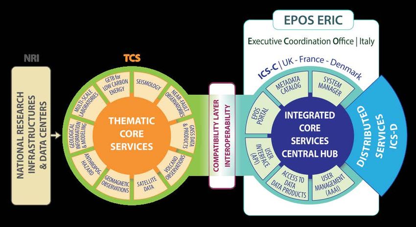
European Plate Observing System – EPOS
EPOS Preparatory Phase Project (2010 – 2014) – one partner per
country
EPOS Implementation Phase Project (2015 – 2019) – 47 partners, 6
associate partners, 25 countries involved.

                                                                          LRI and Related Projects
                                                                   CzechGeo/EPOS Workshop 2017
                                                                                3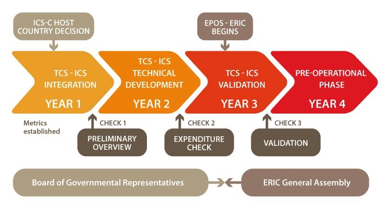
Participation of CzechGeo/EPOS Partners
GNSS Data and Products – RIGTC – see poster Douša et al.
Geomagnetic Observations - IG ASCR
Antrophogenic Hazard – IG ASCR

                                                                  LRI and Related Projects
                                                           CzechGeo/EPOS Workshop 2017
                                                                        4
EPOS Implementation Phase
Implementation Validation Pre-operation
TCS cost assessment
LRI and Related Projects
CzechGeo/EPOS Workshop 2017
Technical End of TCS-ICS
Readiness A. Validation
5EPOS ERIC Partnership (October 2018)
The EPOS-Eric was granted
by the EC on October 30,
2018. The first meeting of
General Assembly was
held on November 7.
LRI and Related Projects
CzechGeo/EPOS Workshop 2017
The Czech Governmental
representative (MEYS)
never visited the meetings
of the Board of
Governmental
Representatives and never
made known if the Czech
Republic is going to join
the EPOS ERIC. 6National Research Infrastructures
• The basis of EPOS – observations of all countries are asked to
contribute
• The institutions operating observatories will sign a supplier
letter.
LRI and Related Projects
CzechGeo/EPOS Workshop 2017
7CzechGeo/EPOS 2010 – 2015
• Czech geoscience institutions responded in 2009 to the Call for Proposal and
started integration of the scattered stations and networks into CzechGeo/EPOS –
Distributed System of Permanent Observatory Measurements and Temporary
Monitoring of Geophysical Fields in the Czech Republic – Development and
Operation of the National Node of the Pan-European EPOS Project.
• Participating institutions
LRI and Related Projects
CzechGeo/EPOS Workshop 2017
• Institute of Geophysics of the CAS (IG CAS) – Hosting Institution
• Masaryk University, Faculty of Sciences, Institute of Physics of the Earth (IPE MU)
• Charles University in Prague
• Faculty of the Mathematics and Physics, Department of Geophysics (FMP CU)
• Faculty of Science, Institute of Hydrogeology, Engineering Geology and
Applied Geophysics(FS CU)
• Institute of Geonics of the CAS, Ostrava (IGN CAS)
• Institute of Rock Structure and Mechanics of the CAS, Praha (IRSM CAS)
• Research Institute of Geodesy, Topography and Cartography, Zdiby (RIGTC) 8CzechGeo/EPOS 2016 – 2019
CzechGeo/EPOS – Distributed System of Permanent Observatory
Measurements and Temporary Monitoring of Geophysical Fields
• Czech Geological Survey was invited to join the RI team (in
accordance with the EPOS strategy)
LRI and Related Projects
CzechGeo/EPOS Workshop 2017
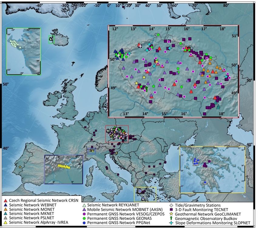
The Infrastructure (about 20 networks and data centers) was
divided into five Sections:
1. Section of Seismology (IG CAS)
2. Section of GNSS and Gravimetry (RIGTC)
3. Section of Crust Geodynamics (IRSM CAS)
4. Section of Geomagnetism (IG CAS)
5. Section of Geological and Geophysical Databases (CGS) 9CzechGeo/EPOS 2016 – 2019
1. Section of Seismology
• 6 networks, over 70 stations
• pool of 63 mobile stations
• Near Fault Observatory planned in
West Bohemia
• Seismological Software Centre
2. Section of GNSS and Gravimetry
• 3 permanent networks, 50 stations
• epoch-style observations on 60
sites
LRI and Related Projects
CzechGeo/EPOS Workshop 2017
• Gravimetric Observatory
• GOP Data, Analytic and Software
Centre
3. Section of Crust Geodynamics
• monitoring of fault displacement
(160 sites), slope deformation (10
sites), temperature profile in
boreholes (5 sites)
• tide observatories
4. Section of Geomagnetism
• Geomagnetic Observatory
• geomagnetic and magnetotelluric
mobile sets 10
5. Section of geological and
Activities of all sections and or results based on their data will be
geophysical databases
presented in the next talks.Projects to support the infrastructure
2010 – 2015, LM2010008, CzechGeo/EPOS, MEYS (state budget)
• investments and non-investments to support RDI and operation of
the infrastructure
• no support of geoscience research activities
2016 – 2019, LM2015079, CzechGeo/EPOS, MEYS (state budget)
LRI and Related Projects
CzechGeo/EPOS Workshop 2017
• non-investments to support RDI and operation of the infrastructure
• no support of geoscience research activities
2017 – 2020, CZ.02.1.01/0.0/0.0/16_013/0001800, CzechGeo/EPOS-
Sci, OP Research, Development and Education
1. Project management
2. Modernization of observatory infrastructure - investments
3. Performance of geoscience research programs
11CzechGeo/EPOS–Sci
• Research programs
1. Investigation of intraplate seismicity on the territory of the
Czech Republic and in close surroundings (SEIS)
2. Structure of continental lithosphere and mapping LAB
boundary in a broader surroundings of the Alps (DeepAlps)
LRI and Related Projects
CzechGeo/EPOS Workshop 2017
3. Development of infrastructure in the field of GNSS, gravimetry
and Earth tides (GNSSgrav)
4. Geodynamics
5. Geological and Geophysical Data Infrastructure to Support
Research
12Service to the user community
Access to data
Open: CRSN, GEOMAG, Seismological Software Centre
(registration), CARBONET, VESOG GNSS (not all stations), GOP
data, Gravimetric station Pecný, CGS-DRI-partly
LRI and Related Projects
CzechGeo/EPOS Workshop 2017
Open on request: PSLNET, PPGNet, WEBNET (location of seismic
events and life seismograms available on-line), MONET,
NFOWEB, CZET Skalná, GeoCLIMANET, TECNET, MKNET,
SLOPENET, CGS-DRI-partly
Embargoed for a limited time: REYKJANET, MOBNET, CZET Jezeří
(funded by a commercial partner), CZEPOS, CGS-DRI-partly.
Data providers or data centre operators may apply regulations
for commercial use of data (typically CC 4.0 BY NC) 13Service to the user community
National Impact
CzechGeo/EPOS
• is indispensable for any geoscience research on the territory
of the Czech Republic
LRI and Related Projects
CzechGeo/EPOS Workshop 2017
• used in numerous research papers
• used in applications
• frequently used in Master and PhD theses
• students are also involved in data acquisition and processing
14Service to the user community
International overlap
• international cooperation in operation of several networks
(PSLNET, PPGNet – Greece, Reykjanet – Iceland, TECNET –
stations in 15 countries)
LRI and Related Projects
CzechGeo/EPOS Workshop 2017
• participation in large international research projects (recently
AlpArray
• participation in EPOS (CzechGeo/EPOS was the first national
consortium among EPOS countries established in 2010)
• contributing to global and regional data centres
• used in numerous research papers
15Service to the user community
World or regional thematic data centres
• Seismic data: ORFEUS (Observatories and Research Facilities for
European Seismology) http://www.orfeus-eu.org/, EMSC (The
European-Mediterranean Seismological Centre) http://www.emsc-
csem.org, Geofon http://geofon.gfz-potsdam.de, IRIS
http://ds.iris.edu/ds/ , International Seismological Centre
LRI and Related Projects
CzechGeo/EPOS Workshop 2017
http://www.isc.ac.uk/, NOAA Earth Information System
https://www.esrl.noaa.gov/neis/
• Data from GNSS stations: EPN (EUREF Permanent Network)
http://epncb.oma.be) and IGS (International GNSS Service
http://www.igs.org). Freely accessible at
http://epncb.oma.be/ftp/center/data/BKGE.RDC or at
ftp://igs.esgn.ign.fr.
• Gravimetric data: IGETS (International Geodynamics and Earth Tide
Service) http://igets.u-strasbg.fr)
• Geomagnetic data: INTERMAGNET (International Real-time Magnetic
Observatory Network) http://www.intermagnet.org/index-eng.php, 16
World Data Centre for Geomagnetism http://www.wdc.bgs.ac.uk/Service to the user community
Societal impact (examples)
• data from seismology monitoring are closely linked to seismic
hazard at nuclear power plants and nuclear waste repositories
• SLOPENET network contribute to the security of
LRI and Related Projects
CzechGeo/EPOS Workshop 2017
infrastructures in the areas exposed to slope deformation
• CZET monitors slope stability around deep open pit mine
• WEBNET is cooperating with the company responsible for
safety of water dams and reservoirs as well as with local
authorities in case of intensive seismic swarms.
• seismic records of station VRAC are provided to IDC CTBTO in
Vienna as a part of the international monitoring of nuclear
tests 17Thank you
LRI and Related Projects
18
CzechGeo/EPOS Workshop 2017You can also read