Dams of South India by Pankaj Kumar Sharma - Advanced Topics in Hydraulics, Hydrological Sciences and Hydrometeorology for RA-II: 2018
←
→
Page content transcription
If your browser does not render page correctly, please read the page content below
Dams of South India
                                             by

                               Pankaj Kumar Sharma

Advanced Topics in Hydraulics, Hydrological Sciences and Hydrometeorology for RA-II: 2018

                                           May 2018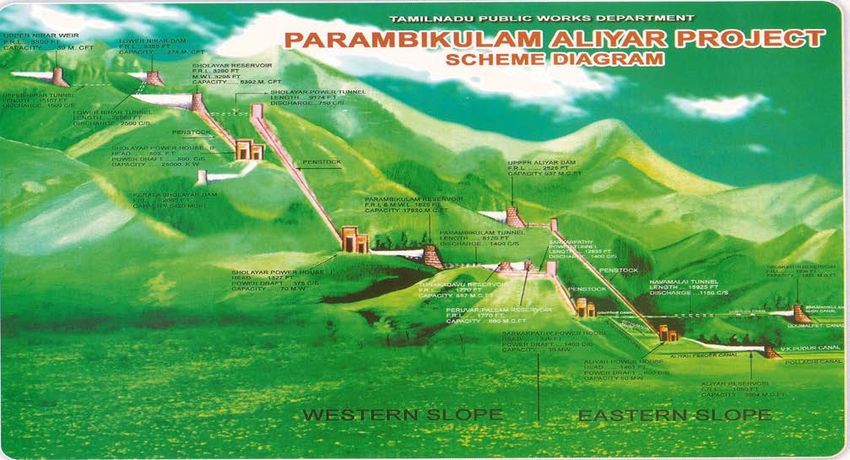
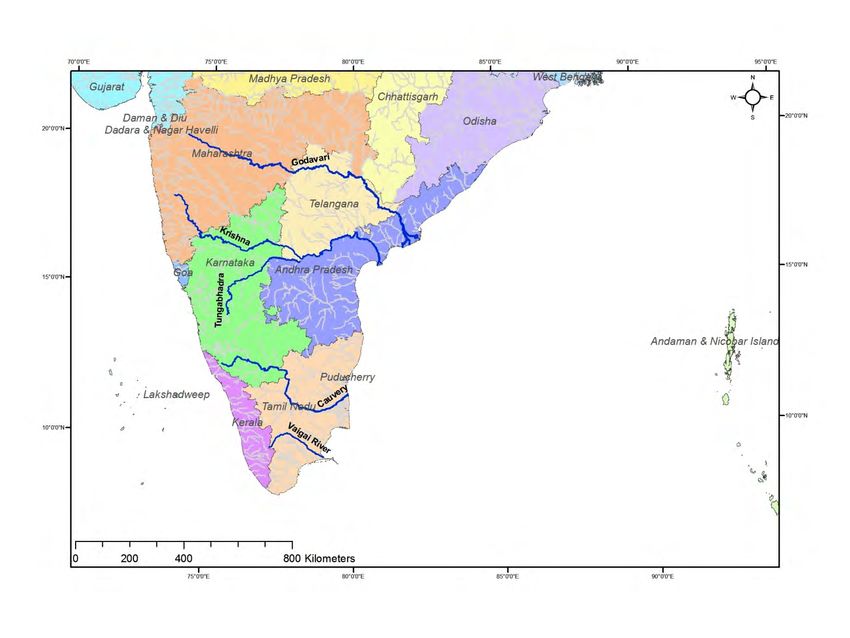
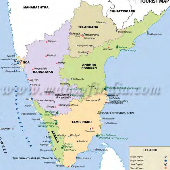
Dams of South India:-
Their type, location, role and importance with respect to water resources utilization along with
challenges involved in effective operation of these dams due to Inter-state issues, a typical situation
of India, where only states (local government) have constitutional power to manage water within
their jurisdiction and role of central government (federal government) is limited to providing
technical and financial assistance to State Governments.

Introduction:
Where is South India?
The geographical area depicted by phrase “South India” is not defined officially. It is perceived as
an area south of peninsular deccan plateau consisting mainly of the Indian states of Tamil Nadu,
Karnataka, Kerala, Andhra Pradesh and Telangana as well as the union territories of Andaman and
Nicobar, Lakshadweep and Puducherry. The geography of the region is diverse with two mountain
ranges - the Western and Eastern Ghats, bordering the plateau heartland. Godavari, Krishna, Kaveri,
Tungabhadra and Vaigai rivers are important non-perennial sources of water. Bengaluru , Chennai,
Hyderabad, Kochi, Coimbatore, Mysore and Thiruvananthapuram are the largest urban areas.

Figure 1: Major States and river of South India
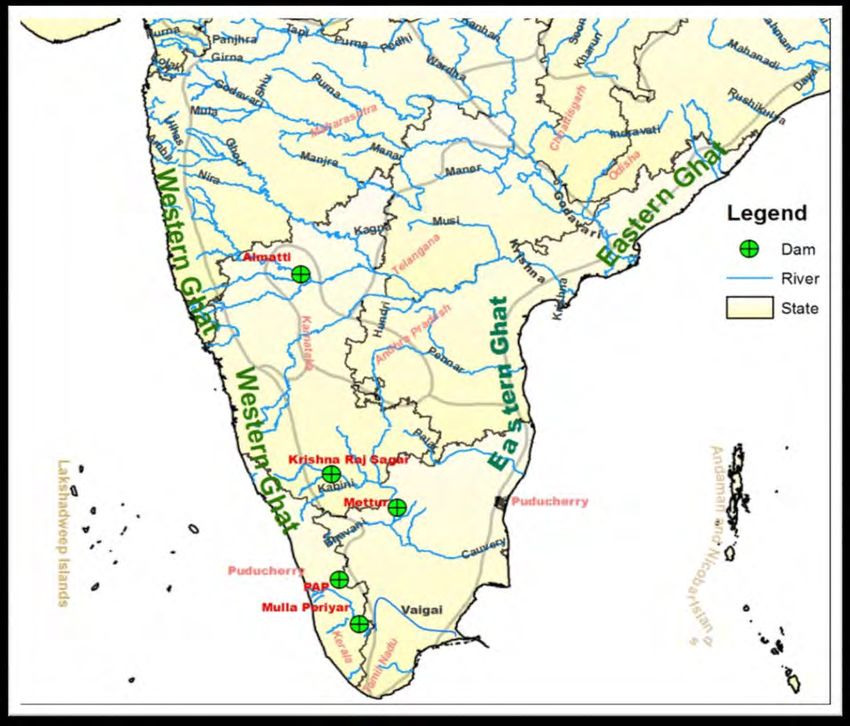
Figure 2: Major States and Cities of South India
Status of Large dams in South India:

The National Register of Large Dams in India provides details information about large dams (as per
International Commission on Large Dams - ICOLD definition) in the country.
From the above list, it can be seen that the South Indian states of Tamil Nadu (116), Karnataka
(231), Kerala (62), Andhra Pradesh (167) and Telangana (184) as well as the union territories of
Andaman and Nicobar (2), Lakshadweep (0) and Puducherry (0) account for 762 large dams
among themselves.
Water resources and Inter-State Matters:
Ministry of Water Resources, River Development and Ganga Rejuvenation provides information on
its website related to “WATER IN INDIAN CONSTITUTION.
India is union of States. The constitutional provisions in respect of allocation of responsibilities
between the State and Centre fall into three categories: The Union List (List-I), the State List (List-
II) and the Concurrent List (List-III).
As most of the rivers in the country are inter-State, the regulation and development of waters of
these rivers, is a source of inter-State differences and disputes. In the Constitution, water is a matter
included in Entry 17 of List-II i.e. State List. This entry is subject to the provision of Entry 56 of
List-I i.e. Union List.”
Entry 17 of List-II i.e. State List:
Entry 17 under List II of Seventh Schedule Entry 17 under List II of Seventh Schedule provides that
"Water, that is to say, water supplies, irrigation and canals, drainage and embankments, water
storage and water power subject to the provisions of Entry 56 of List I".
Entry 56 of List-I i.e. Union list:
Entry 56 of List I of Seventh Schedule provides that "Regulation and development of inter-State
rivers and river valleys to the extent to which such regulation and development under the control of
the Union is declared by Parliament by law to be expedient in the public interest".
Parliament has enacted “THE INTER-STATE RIVER WATER DISPUTES ACT,1956” in
pursuance of the above provisions of constitution to resolve the inter-state disputes related to water.
The ongoing disputes and their status can be seen on website mowr.gov.in drop-down menu.
Also, Chapter X of Annual Report 2015-2016 of CWC provides detailed information about Inter-
State Water Disputes and steps taken to resolve them.
In this report, following 5 dams out of 762 shall be discussed based on their importance and inter-
state issues:

   1. Mulla Periyar Dam
   2. Parambikulam Aliyar Project (PAP)
   3. Krishna Raj Sagar dam
   4. Mettur dam
   5. Almatti dam
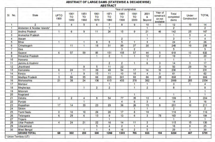
Figure 3: Location of above five dams in South India
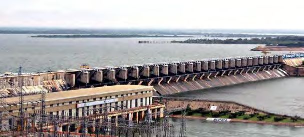
1. Mullaperiyar Dam
The Mullaperiyar Dam is a masonry gravity dam on the Periyar river in the Indian state of Kerala It
is located 881 m (2,890 ft) above mean sea level, on the Cardamom Hills of the Western Ghats in
Thekkady, Idukki District of Kerala, South India.
Figure 4: Mullaperiyar Dam
Inter State Angle
The control and safety of the dam and the validity and fairness of the lease agreement have been
points of dispute between Kerala and Tamilnadu states.
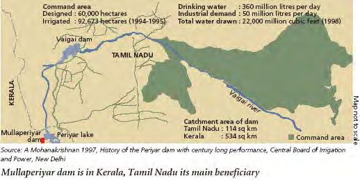
For Tamil Nadu, the Mullaperiyar dam and the diverted Periyar waters act as a lifeline for Theni,
Madurai, Sivaganga and Ramnad districts, providing water for irrigation and drinking, and also for
generation of power in Lower Periyar Power Station.
For Kerala, safety concerns posed by the 119-year-old dam to the safety of the people of Kerala in
the event of a dam collapse, have been the focus of disputes from 2009 onwards. Kerala's proposal
for decommissioning the dam and constructing a new one has been challenged by Tamil Nadu.
The details of the legal tussle between Kerala and Tamilnadu over the dam can be perused at links
given at the end of the report.
On directions of Supreme Court, a Dam Break Analysis of the Dam and its downstream reaches
upto Iddukki dam has been conducted by IIT-Roorkee. A summary of their findings is reproduced
below:
Conclusions from the study:
1. The literature suggests the HEC-RAS version 5.1.0 model to be quite popular and standard
software developed by Hydrologic Engineering Centre of U. S. Army Corps of Engineers
for dam break analysis.
2. The consideration of the overtopping mode of failure along with the following breach
parameters (as per FERC guidelines) is reasonable for dam break flood generation: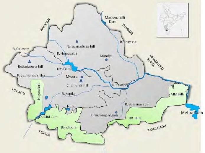
Elevation of Breach                Average Breach         Side Slope of    Breach Development
                                             Width                 Breach               Time
                 (m)
                                                 (m)                                        (hr)

   Initial              Final

873.26         825.94               195.5                    Vertical (1:1)     0.2

Table 1: Dam break model parameters

   3. The generated peak of the dam break flood hydrograph is estimated at 88911.00 c umecs,
      which is 10.25 times of the peck of Probable Maximum Flood Hydrograph.
   4. The depths of flows at different locations within the river reach of 36 km vary from 40.30 m
      (just below the Mullaperiyar Dam site) to 20.85 a t the end of the reach (chainage 36 km
      from Mullaperiyar Dam).
   5. The following table shows the resulting maximum discharges, maximum water surface
      elevations, and time of occurrence of the maximum water surface elevations in the channel.

         Place             Section No.     Location       Maximum Water          Time of      Velocity
                                          from dam        Surface Elevation      Arrival       (m/s)
                                             (m)                 (m)            (minutes)
Mullaperiyar               1             50            866.90                   18            9.47
Vallakkadavu               11            3597          854.35                   26            12.41
Vandiperiyar               21            7422          844.77                   31            9.36
Upstream of Idukki 46                    35969         767.26                   128           8.50
Reservoir
Table 2: Results of Dam break analysis

   6. Among the inputs of Manning's roughness (N), Probable Maximum Flood (PMF), dam
      breach parameters such as breach width and time of breach development and Δx (space) &
      Δt (time)steps, the Manning's roughness (N) appeared to be the factor most influencing the
      maximum water surface elevations. Although conservative a value of N = 0.034 was
      considered to be reasonable for the reach between Mullaperiyar and Idukki Reservoir.
   7. The sensitivity analysis showed the model generated output to be reliable for chosen timed
      space steps.

The above study helped in controlling the mis-information being spread around the area.

Roughly, it was preliminarily estimated that a dam-break would directly affect 32,503 people and
8,942 houses in seven villages situated down the dam. Sixty-nine shelters would have to be built for
the safety of people and total cost estimated for the construction was Rs 20 crore.

The above case study is related to the first and second week of course concerned with dam failure
concepts and dam break analysis.
Which further highlights the importance of course on Advance Hydrology.

In 2006, the Supreme Court of India by its decision by a three-member division bench, allowed for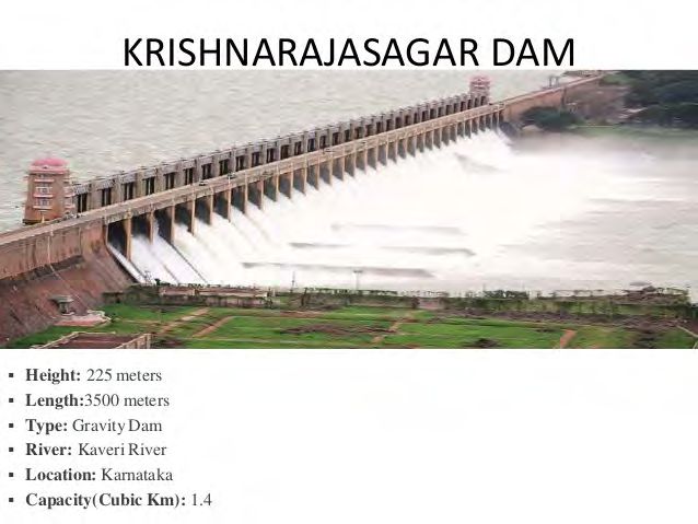
the storage level to be raised to 142 feet (43 m) pending completion of the proposed strengthening
measures, provision of other additional vents and implementation of other suggestions.

2.     Parambikulam Aliyar Project(PAP)

Figure 5: PAP project view

Inter state angle
In sharp contrast to the above Mullaperiyar Dam , this project is a story of long cooperation
between states of Kerala and Tamilnadu.

Parambikulam-Aliyar project (PAP) agreement signed between Tamil Nadu and Kerala on May 29,
1970 has retrospective effect from November 9, 1958. The agreement is aimed at beneficial
sharing of waters of the Bharathapuzha, the Chalakudy and the Periyar and implementation of
projects by the two States.

It successfully accompalishes the diversion and integration of eight western flowing rivers, six in
the Anamalai hills and two in the plains for the benefit for the drought prone regions of
Coimbatore and Erode district of Tamilnadu and stabilizing the existing irrigation system in the
Chittorrphuza of Kerala state.
3.     Krishnarajasagar Dam

Figure 6: Krishnarajasagar Dam
The dam was built across river Cauvery in 1924. It is the main source of water for the districts of
Mysore. The water is used for irrigation in Mysore and Mandya districts of Karnataka and it is the
main source of drinking water for all of Mysore, Mandya and almost the whole of Bengaluru city,
the capital of the state of Karnataka. The water released from this dam flows into the state of Tamil
Nadu, and is stored in Mettur dam in the Salem district.

Figure 7: Location of Kabini, Krishnarajasagar and Mettur Dams on Cauvery river
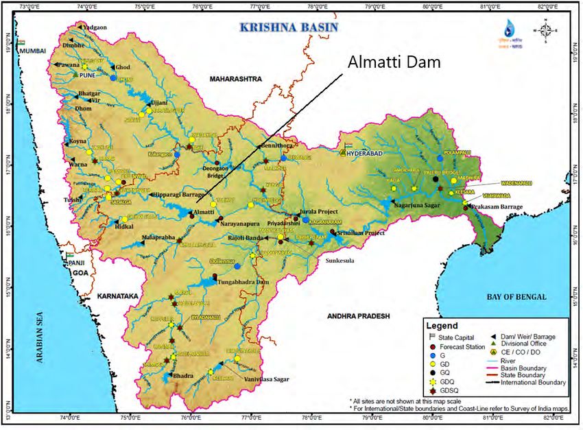
4.     Mettur Dam
The Mettur Dam is one of the largest dams in India and the largest in Tamilnadu located across the
river Cauvery where it enters the plains. Built in 1934 took 9 years to complete. Maximum height
and width of the Dam are 214 and 171 feet respectively. The Dam receives inflows from its own
catchment area, Kabini Dam and Krishna Raja Sagara Dams located in Karnataka.

Figure 8: Location of dams on Caurvery river viz Kabini, KRS and Mettur Dam

Inter State Angle

The above dams on Cauvery river are in dispute between the States of Tamil Nadu and Karnataka.
Because of subsequent dams constructed across the Cauvery and its tributaries in Karnataka,
namely Harangi Dam, Hemavathi Dam, Kabini Dam, following the KRS Dam; Mettur Dam does not
receive much water during lean seasons. As a result, the dam nearly goes dry lean season, often
when water is most needed by the farmers and the general public of Tamil Nadu. The orders of
court / tribunals are resented by parties concerned and often seen as favouring the other party.

5.     Almatti Dam
The Almatti Dam is a hydroelectric project on the Krishna River in North Karnataka, India which
was completed in July 2005. The Krishna River conflict between Andhra Pradesh, Karnataka, and
Maharashtra is still ongoing. Meanwhile by the order of Krishna Water Disputes Tribunal –II also
known as Brijesh Kumar Tribunal the dam was authorised to be raised to the height of 524.256 m
MSL from 519.6 m with nearly 200 TMC gross storage capacity.

Figure 9: Location of Almatti Dam in Krishna basin
Inter state angle

Figure 10: Almatti Dam
The total allocation of the 3 S tates including those made by KWDT-I come to 666 T MC for the
State of Maharashtra, 907 TMC for the State of Karnataka and 1005 for the State of Andhra
Pradesh. Matter is still sub-judice.
Summary

India has 2.4% of the World’s land, 18% of world
population but only 4% of the renewable water resource. If
sufficient steps are not taken, the uneven water distribution
will increase the possibility of water conflicts with rising
population, urbanisation and Industrialization.
The Inter-State River Water Disputes are one of the most
contiguous issues in the Indian federalism today.
Hydrological Study and analysis helps in resolving these
issues analytically. These study also help in controlling the
mis-information being spread in public. Which further
highlights the importance of course on Advance Hydrology.
Sources:

https://en.wikipedia.org/wiki/South_India

https://gramener.com/map/

https://gramener.com/indiamap/

https://www.mapsofindia.com/south-india-travel.html

http://cwc.gov.in/main/downloads/NRLD_04012017.pdf

http://cwc.gov.in/main/downloads/Annual%20Report%20CWC_%202015-16.pdf

http://mowr.gov.in/water-indian-constitution

http://mowr.gov.in/acts-tribunals/acts/inter-state-river-water-disputes-act

https://en.wikipedia.org/wiki/Mullaperiyar_Dam

http://www.sci.gov.in/jonew/judis/41511.pdf

https://www.expert-eyes.org/mullaperiyar/index.html

https://economictimes.indiatimes.com/news/politics-and-nation/dam-break-analysis-on-
mullaperiyar-completed-kerala-government/articleshow/12160744.cms

https://www.aanavandi.com/blog/specials/videos/what-will-happen-to-kerala-if-mullaperiyar-dam-
breaks
You can also read