DATAFEEDS FOR BUSINESS AND GOVERNMENTAL BODIES
←
→
Page content transcription
If your browser does not render page correctly, please read the page content below
DATAFEEDS FOR BUSINESS AND GOVERNMENTAL BODIES
Ben Rutten, Product Manager Mobility Solutions, TomTom, Rembrandtplein 35, 1017 CT Amsterdam,
        The Netherlands, ben.rutten@tomtom.com, +31 6 290 525 69
Joe Dixon, Technical Director Mobility Solutions, TomTom, Pentlands Science Park, Bush Loan,
        Penicuik Midlothian, EH 26 0PZ, United Kingdom, joe.dixon@tomtom.com
Peter-Frans Pauwels, Chief Technical Officer, TomTom, Rembrandtplein 35, 1017 CT Amsterdam,
        The Netherlands, peter-frans.pauwels@tomtom.com

                                          ABSTRACT
Current available traffic information does not really meet the consumer needs: travel time, delay time,
estimated time of arrival on a door-to-door basis, fully integrated in a personal navigation device, with
seamless cross-border information services. As the market leader in car navigation, TomTom’s vision
is to bring a brand new navigation experience towards the market. Measured travel time information
will be integrated into TomTom’s navigation devices. By doing this, the consumer will be helped a
tremendous step forward in planning his trip and driving his car. TomTom’s ambition is to build up a
PAN-European traffic information service. The traffic information collection will be based upon
monitoring data from millions mobile phones in GSM networks fused with other data sources when
available. Once the travel time collection system is in place, data feeds for governmental bodies (B2G)
and business parties (B2B) will be brought to the market. TomTom will develop a partner program for
selling the several data feeds.

                                      INTRODUCTION
Today TomTom is market leader in car navigation.
The company helps people get from A to B stress
free in more than 20 countries. TomTom has three
main product ranges. First, users of PDAs and
smartphones can plug in TomTom Navigator
software, services and GPS devices that will send
them safely and quickly from door to door. Second,
TomTom makes all-in one navigation devices; the
TomTom GO and the TomTom ONE are the easiest
to use and most portable stand-alone car navigation
devices ever. Third, the TomTom RIDER is the
easiest to use and most portable stand-alone
motorbike and scooter navigation device in his sort.
TomTom gives all its customers local information,
entertainment and assistance with foreign languages
while on the move. And TomTom is constantly
developing new and smarter products.

At the moment there is a lack of reliable traffic information. Besides, in the whole navigation market,
traffic information is poorly integrated in the navigation devices. Amongst others, reasons are: there
are many sources, but they do not realize a complete picture of the actual traffic situation, and
although partly reliable, overall there is not a reliable service available right now. Another obstacle is
that existing traffic information collection systems do not cover the complete (main) road network.
Even when national motorway networks entirely had been covered, what is not the case, even then a
car driver get stuck in ignorance of any traffic information, when he leaves the motorway network.
Furthermore, the reported congestion format is the length of traffic-jams, without knowing what the
time delay will be. And last-but-not-least, there is a lack of personalized information. It makes no
sense to an individual to report all traffic-jams all over the nation. Finally, for regional cross-border
traffic, there are no seamless solutions available today.
Summarizing, the consumer needs: travel time, delay time, estimated time of arrival on a door-to-door
basis, fully integrated in a personal navigation device, with seamless cross-border information
services.

                                                    1
TomTom has the ambition to add excellent travel time information on his navigation devices and to
offer an improved navigation experience to his customers. Besides that, TomTom also has the
ambition to deliver data feeds towards business parties and governmental bodies, e.g. for better fleet
management and dynamic traffic control measures.
TRAVEL TIMES ON ENTIRE ROAD NETWORK
With the acquisition of the Scottish Enterprise Applied Generics, TomTom has now the opportunity to
produce travel times on the entire road network, by processing the monitoring data from the mobile
telephone network through the RoDIN24 software from former Applied Generics. When a partnership
with a mobile GSM-network operator is in place, TomTom’s RoDIN24 software will be installed and
operated within the mobile network, generating raw traffic data. In TomTom’s hosting centre, this raw
data will be processed for further use on the navigation devices of TomTom’s customers.
TRAVEL TIMES OUT OF GSM MONITORING DATA
Timing Advance
TomTom’s RoDIN24 software makes possible to monitor the GSM-network
passively for location data arising from normal subscriber activity. In its most
basic form the data indicates which cell a particular subscriber is in. However, a
single cell may cover an area of up to 4000km2 and such a coarse resolution is
clearly impractical for the purpose of road traffic monitoring. In networks based
on the GSM system, representing millions of subscribers, a further refinement is
possible.
Whenever a handset is in call, using the GSM-network Timing Advance (TA)
compensation reports, the handsets location can be narrowed to a 550m wide
concentric band radiating from the cell site. Although better than knowing only
the cell, the use of the TA must be regarded as coarse grained - in the worst
case, there is still an area of uncertainty of 100km2, which is clearly unsuitable
for discriminating which road a driver is travelling along. By analysing a
sequence of TA reports from a particular handset over a short period of time, its
route and speed can be determined.
Travel time computation
An example using this patented technology, using sequential TA reports
received from a single anonymous subscriber, is illustrated in Picture at the left.
This figure shows a section of the UK road network in the Edinburgh region and
seven snapshots of the positions associated with the TA reports received. At the
time of the first report, the system knows that there is a subscriber in the
highlighted region. As further reports arrive, the system identifies the handset as
moving and performs a detailed analysis on the possible routes that may have
led to such a sequence of reports. Specifically, by the time report 4 is processed,
it is possible to generate a set of routes involving highways 1, 2 and 3. Given the
time taken for each of these possible routes, the system generates speed and
probability metrics. In report 5 the subscriber switches to a different cell. Taken
in isolation, this report places the subscriber in a large area. However, the
system determines that the subscriber is on highway 1 because there are no
plausible routes from highways 2 and 3 to highway 1 in the time since report 4.
At this point, the system refers to the historical data for the subscriber, and
generates an accurate route and transit time for the highway 1 journey. Reports
6 and 7 continue to provide accurate speed information along highway 1.
Although based on real network geometry, this is a simple example, and any
robust analysis must cope with far more complex road and mobile network
geometries.
Picture: timing advance reports for a moving subscriber.
2CHARACTERISTICS OF GSM APPROACH
Sensor network
This approach compares favourably with deploying a fixed sensor network with sensors spaced every
550m. Indeed, in areas with dense mobile network coverage, the overlaps between adjacent cells
serves to improve the accuracy to the order of a few hundred metres. By gathering route and speed
data for many subscribers, a statistically significant view of the road traffic situation is maintained.
Natural behaviour car drivers
Uniquely, this data can be gathered without making expensive additions to or using capacity on the
mobile network. In common with all FCD systems, the behaviour of subscribers works in our favour.
When a road is lightly used and free flowing we need few reports to declare such a situation, but when
congested, there are typically more drivers on the road and hence the data available to the system
increases. When unexpected congestion occurs, caused by an accident or other reasons, the natural
behaviour of the driver favourites our system: people start calling emergency services or start making
business calls or calls communicating a delayed expected arrival time or call just out of pure boredom.
Scaleable architecture
The architecture of the system is designed to be very scaleable. RoDIN24 runs on collection servers.
In each switch in the GSM-network, a collection unit is placed. Each collection unit generates road
traffic information for a specific geographic area. These data streams are collected in the TomTom’s
data and hosting centre to form a national traffic information database which may then be accessed
through application oriented services.
Proven technology
Large scale trials of RoDIN24 have taken place in several European countries. At the moment a 2
year full commercial deployment of RoDIN24 till summer 2007 is in operation in the 6000 km2 Dutch
Province of Noord-Brabant, feeding LogicaCMG’s Mobile Traffic Services system, especially designed
for use by road authorities.
Calibration with GPS feeds
TomTom navigation devices know each of them exactly the position at each moment by the integrated
GPS location functionality. When available, TomTom will use these GPS feed to calibrate the massive
GSM data feed coming from the operator mobile network. This will enhance the existing RoDIN raw
traffic information.
NEW NAVIGATION EXPERIENCE
Tomtom’s vision is to bring a brand new navigation experience towards the market. Historic and actual
travel times will be integrated into TomTom’s navigation platforms. Bringing together existing
navigation possibilities and actual travel times in one device, will help the consumer a tremendous
step forward in planning his trip and driving his car.
PERSONALIZED NAVIGATION AND TRAFFIC INFORMATION
Instead of listening to traffic reports on the radio with a long list of queues throughout the nation, using
TomTom’s new coming navigation experience, the traveller has no worries anymore. He will be
assisted in car driving and will have always the most optimal door-to-door routing with the shortest
travel time at that particular moment.
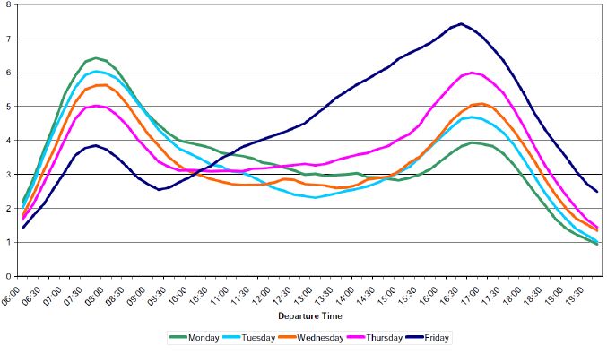
The traveller can plan his trip in advance. The navigation device will use the integrated very rich
historic time series of travel times, see next picture.
Once on the road, his trip will be updated and rerouted if necessary when unexpected time delays
arise due to unexpected congestion by accidents or other causes.
This new navigation experience will really assist the car driver. Car driving will be easier and safer,
because the consumer knows at each moment what his estimated time of arrival will be. This will give
him a more comfortable feeling, what will result in less hasty driving and thus more safer roads.
3Picture: Profile over weekdays (source: DfT 2006-02-14)
PAN-EUROPEAN ROLLOUT
TomTom’s ambition is to bring this new navigation experience to all markets where TomTom devices
are available right now. Of course it is not possible to do this in one day, because the travel time
collection infrastructure has to be built up together with mobile operators and it has to be aligned with
many activities within the TomTom group. At least TomTom’s ambition is to start this new navigation
experience in the European navigation arena, starting with the Netherlands. Next steps will be bringing
the new navigation experience over the European continent with excellent services, including cross
border traffic services.
The ambition is to build up a PAN-European service. To achieve this, all involved expertise within the
TomTom group will be mobilised: marketing, sales, product management, research, development,
ICT, customer support and design of the architecture of this PAN-European traffic services.
DATAFEEDS FOR THIRD PARTIES
Once the travel time collection system is in place, not only real time data feeds of the actual traffic
situation are available, but also the building up of a historic database will be started. This historic
database is extremely useful for governmental bodies (B2G) for infrastructure planning, traffic and
travel time analysis and other traffic engineering purposes. For business parties (B2B) knowledge of
the actual traffic situation will help their employees.
BUSINESS PARTIES
Planning their car fleets in a better way has the continuous attention of business parties. Arrival and
delivery times are often a customer’s first impression of a logistic service business party. Recently
TomTom introduced Connected Navigation with the TomTom WORK solution. TomTom WORK brings
Connected Navigation to the mass market of small business parties. It is combination of tracking &
tracing (knowing anywhere anytime anybodies car position), navigation (the shortest route to next
destination) and communication (rerouting and prioritising trips). A data feed with the actual traffic
situation is a logical next step as soon as the new traffic service is available. Whether this will be the
new navigation experience as stated before or more dedicated services towards the TomTom WORK
solution is still under development.
In the business to employee market hundreds of thousands commuters have their daily travel
challenge during rush hours. Roads are crowded, and they should be helped, when they know before
4leaving their home or their office, what the traffic situation is at that moment on several alternative
routes. Combination of pre-trip information services and in-car navigation helps both employees for
more comfortable travelling, helps their employer for better spending their working hours and will
benefit better road capacity utilization.
Another interesting business is the service provider market. The triple A’s in many countries have
traffic information services in place, but certainly need a more complete traffic picture. They struggle
also with the deficiencies as described in the introduction paragraph. A complete traffic picture will
help them to perform better their service provider business.
TomTom will design all traffic services for the business market in a way that they do not cannibalize
the services on the TomTom personal navigation devices.
GOVERNMENTAL BODIES
Until now a lot of effort has been made in developing the governmental market. LogicaCMG’s
partnership with former Applied Generics resulted in the introduction of LogicaCMG’s Mobile Traffic
Services, based upon RoDIN24, in the road authorities market. The technology is at the verge of a
breakthrough and several evaluating studies have shown the good quality of the RoDIN24 data.
Pricing and delivery models have been developed and accepted in the market. Both regional and
national governmental organizations are planning tendering procedures and have claimed budgets in
their plans for the coming years.
Examples for the B2G portfolio are:
1. A general web portal with a real time speed map and additional functionality for public information
purposes or traffic management goals;
2. A web based historical traffic management analysis tool;
3. A travel time interface for VMS.
TomTom will design all services for the governmental market in a way that they do not cannibalize the
services on the TomTom personal navigation devices.
PARTNER PROGRAM
The TomTom Mobility Solutions Division will develop a partner program for selling the several data
feeds. TomTom will help the partners by marketing the standard portfolio solutions in the B2G market.
TomTom realizes that customers in the governmental market are interested in complex and tailor
made solutions. A partner program with one or more system integrators and specialized installation
companies seems necessary to bring the data feeds in the necessary formats and applications
towards the market.
ACKNOWLEDGEMENTS
TomTom helps people find their way. We use the very latest technology to do this,
building it into all-in-one navigation solutions, handheld computers and
Smartphones. The company was founded in 1991 in Amsterdam, and has grown to
supply a market that spreads across the whole of Europe and North and Central
America. Our navigation solutions are now used by more than 3 million customers
in 20 countries and 36 languages. We love what we do, and are continually
exploring new and better ways to help mobile people reach their destinations
quickly, safely and as easily as possible.
5REFERENCES
Jong, R.P. de; Klunder, G.A.; Oldenburger, A.H.; Versteegt, H.H.; Baan, J.; Evaluatie Floating Car
Data en Road Side Radar Zuid-Holland; TNO; Delft; Maart 2006 (in Dutch)
Vlist, M.J.M. van der; Brandt, F.; Janse W.J.H.; Brabantse Wegen Beter Zichtbaar, Validatie MTS;
Goudappel Coffeng; Deventer; 2004 (in Dutch)
Koning, A.J. de; Rutten B.J.C.M.; Making a business of Travel Information; ITS Europe Conference;
Hannover; June 1-3, 2005
Vlist, M. van der; Wolff, P. de; Rutten, B.J.C.M. ; Verkeersgegevens op basis van mobiel
telefoonverkeer; Colloquium Vervoersplanologisch Speurwerk; Zeist; November 25-26, 2004 (in
Dutch)
Rutten, B.J.C.M.; Wolff, P. de; Vlist, M. van der; GSM as the source for traffic information; ITS World
Conference; Nagoya; October 18-21, 2004
Rutten, B.J.C.M.; Vlist, M. van der; Wolff, P. de; GSM as the source for traffic information; European
Transport Conference 2004; Strasbourg; October 4-6, 2004
Rutten, B.; Schuurbiers, R.; Wolff, P. de; Floating Car Data per mobiele telefoon; Verkeerskunde; Den
Haag ; December 16, 2003 (in Dutch)
Rutten, B.J.C.M.; Hoevenaars, G.; Boelen, A.; Personalised Wireless Traffic Information Services; ITS
World Conference; Sydney; Sept 30 -Oct 4, 2001
Rutten, B.J.C.M.; Hoevenaars, G.; Nooit meer in de file dankzij mobiel internet; Natuur en Techniek
Wetenschapsmagazine; April 1, 2001 (in Dutch)
Hoevenaars, G.; Rutten, B.J.C.M.; The Intelligent vehicle as enabler for distributed traffic control; ITS
World Conference; Turin; November 6-9, 2000
6You can also read