Deep-Sea Life - Deep Ocean Stewardship Initiative
←
→
Page content transcription
If your browser does not render page correctly, please read the page content below

Deep-Sea Life
Issue 14, January 2020

Welcome to the 14th edition of Deep-Sea Life (a little later than anticipated… such is life). As always there is bound to be
something in here for everyone. Illustrated by stunning photography throughout, learn about the deep-water canyons
of Lebanon, remote Pacific Island seamounts, deep coral habitats of the Caribbean Sea, Gulf of Mexico, Southeast USA
and the North Atlantic (with good, bad and ugly news), first trials of BioCam 3D imaging technology (very clever stuff),
new deep pelagic and benthic discoveries from the Bahamas, high-risk explorations under ice in the Arctic (with a spot
of astrobiology thrown in), deep-sea fauna sensitivity assessments happening in the UK and a new photo ID guide for
mesopelagic fish. Read about new projects to study unexplored areas of the Mid-Atlantic Ridge and Azores Plateau,
plans to develop a water-column exploration programme, and assessment of effects of ice shelf collapse on faunal
assemblages in the Antarctic. You may also be interested in ongoing projects to address and respond to governance
issues and marine conservation. It’s all here folks! There are also reports from past meetings and workshops related to
deep seabed mining, deep-water corals, deep-water sharks and rays and information about upcoming events in 2020.
Glance over the many interesting new papers for 2019 you may have missed, the scientist profiles, job and publishing
opportunities and the wanted section – please help your colleagues if you can. There are brief updates from the Deep-
Ocean Stewardship Initiative and for the deep-sea ecologists amongst you, do browse the Deep-Sea Biology Society
president’s letter. Finally, in 2019 we sadly said goodbye to Rudi Scheltema (WHOI), but you can read about his rich life
and important contributions to marine research and education in this issue.

Many in our deep-sea community work hard to
impart their knowledge to younger generations.
This photo of the issue is a delightful example of
education in action – how can those children fail
to be enthralled with Angelika Brandt adorning
a crustacean and having a giant isopod for them
to cuddle? Just wonderful (and not a hand-held
device in sight… ).

The editors, Dr Abigail Pattenden (University of
Limerick, Ireland), Dr Eva Ramirez-Llodra (REV
Ocean, Norway) & Dr Paris Stefanoudis (University of Oxford / Nekton Foundation, UK) and I all thoroughly enjoyed
reading about your work during the editing process – thank you for your submissions.

Dr Maria Baker (University of Southampton – mb11@noc.soton.ac.uk)

An INDEEP, DOSI and DSBS collaborative publication.

Issue Contents
Cruise News					2            Opportunities					                                                                  38
Project Focus					12		       Wanted 					                                                                        47
Meetings and Workshops			 27 Hot off the Press				                                                               49
Scientist Profiles				    36 Obituaries					                                                                     58
                             Deep-Sea Biology Society Business		                                                 60
Deep-Sea Life 										                                                                                     Issue 14, January 2020

                           Cruise News
    E/V Nautilus telepresence exploration of the U.S. Line Islands (Kingman Reef,
                          Palmyra Atoll, and Jarvis Island)
                                              Steve Auscavitch1 & Rob Pockalny2
1
 PhD Candidate, Temple University, Philadelphia, PA; 2Marine Research Scientist, University of Rhode Island, Graduate
                                              School of Oceanography

In June and July 2019, the E/V Nautilus and ROV
Hercules explored the Kingman Reef & Palmyra Atoll
and Jarvis Island units of the Pacific Remote Islands
Marine National Monument. This expedition was
a follow-up on recent explorations throughout the
Pacific as a part of the 2013-2015 NOAA Campaign
to Address Pacific Monument Science Technology
and Ocean Needs (CAPSTONE). Previous expeditions
had provided brief glimpses at the geological
composition and biological diversity of the deep-sea
environment. This expedition focused on leveraging
previous mapping and exploration dives in order
to maximize bottom time and sampling effort at
undersampled locations within the units. Across 7
dives, we accumulated 117 hours of bottom time
and traversed approximately 23 linear km of seafloor
on seamounts, ridges, and island flanks. Biological
sampling resulted in 76 primary collections,
including 64 deep-water corals, sponges, as well
as their associates. Biological collections targeted Figure 1: Overview map showing the locations of ROV dives and mapping operations
                                                      completed during NA110. Yellow boxes identify the boundaries of the two Pacific
individuals that represented characteristic fauna
                                                      Remote Islands Marine National Monument units. Map credit: Erin Heffron and Ocean
for the area, new records for the Line Islands, or Exploration Trust.
potential new species requiring further examination
by taxonomic experts. In support of geological studies, 39 rocks were collected to better understand seamount ages
as well as characterizing the composition of regional ferromanganese crusts. In total, 28,340 km2 of seafloor were
mapped both in transit between sites and while gap-filling partially mapped seamounts.

Immediate follow-up work to this expedition will focus on identifying high-diversity and high-density deep-water
benthic communities from annotation of ROV video and identification of collected specimens. Ultimately, these data
are valuable additions to management efforts that seek to identify and characterize biodiverse communities and
features within monument boundaries and other data-deficient areas of the central Pacific Ocean.

Expedition links:

Blog: https://nautiluslive.org/blog/2019/06/24/exploring-deep-waters-kingman-reef-palmyra-atoll-and-jarvis-island

                                                                                                                                     2
Deep-Sea Life 										                                                                                                          Issue 14, January 2020

Figure 2 (top left): A mixed assemblage of sea fans and echinoderms at Jarvis Seamount #2 at 1463m. Figure 3 (bottom left): Extensive Madrepora oculata and
Enallopsammia rostrata reef structures and debris fields dominated the southeastern ridge of Jarvis Island between 600-1000m (Photo: 874m). Figure 4 (right): A
striking and enigmatic blue octocoral was observed at high densities along the western carbonate slope of Jarvis Island at 386 m. Photo credit: Ocean Exploration
Trust.

Overview of deep-sea coral diversity: https://nautiluslive.org/album/2019/07/11/get-know-deep-sea-corals-central-
pacific

Benthic biodiversity gallery: https://nautiluslive.org/album/2019/07/08/standout-biodiversity-pacific-remote-islands-
marine-national-monument

           Southeast Deep Coral Initiative (SEDCI): Research Highlights in 2019
            Rachel Bassett1, Caitlin Adams1, Tim Battista2, Kate Overly3, Dan Dorfman1 & Peter Etnoyer2
                            1
                                NOAA affiliate with CSS, Inc., 2 NOAA NCCOS, 3 NOAA affiliate with RTI, Inc.

                                                                SEDCI is a multiyear, cross-line-office project, funded by NOAA’s Deep
                                                                Sea Coral Research and Technology Program. The initiative has been
                                                                exploring and documenting deep-water seafloor habitats (> 50 m) in
                                                                the Caribbean Sea, Gulf of Mexico, and Southeastern US EEZ since
                                                                2016.

                                              In 2019, five expeditions were conducted in partnership with NOAA
                                              Office of Ocean Exploration (OER) and NOAA Coral Reef Conservation
                                              Program (CRCP). Altogether, researchers spent a total of 88 days at sea
                                              in the Atlantic and Caribbean, mapping over 50,000 square kilometers
with 82 remotely operated vehicle (ROV) dives between November 2018 and November 2019.
                                                                                                                    3
Deep-Sea Life 										                                                                         Issue 14, January 2020

Photo credit: NOAA NCCOS. .
Three of the NOAA OER expeditions characterized extensive Lophelia coral habitats in the Northwest Atlantic on the
Blake Plateau. Field teams mapped and explored “Richardson Hills” reef complex and the “Million Mounds” area, the
largest extent of Lophelia reef habitat currently known in US waters. Follow these links to view the expedition websites:
DEEP SEARCH 2019, Windows to the Deep 2019, and the 2019 Southeastern U.S. Deep-sea Exploration.

In the U.S. Caribbean, researchers conducted surveys aboard the NOAA Ship Nancy Foster in the fifteenth year of
coral ecosystem investigations supported by NOAA’s CRCP. The ongoing project is mapping coral reef ecosystems in
the U.S. Virgin Islands and Puerto Rico down to 300 m depth. The 2019 cruise collected samples for the first time. The
team collected octocoral and black corals to support habitat models, contribute to population connectivity studies,
and develop new field guides. Sonar was used to determine distribution and size of fish. Over 170 square miles were
mapped in St. Croix and St. Thomas in depths from 11-324m. ROV surveys traversed 12 km, collecting HD video for
benthic habitat characterization. The northwest shelf of St. Croix, USVI was previously unmapped and unexplored.
These data will assist policy makers and managers regarding essential coral reef ecosystems in the USVI.

Nearby in Puerto Rico, scientists from NOAA National Marine Fisheries Service worked with commercial fishermen to
gather information on habitat association and life history of the Queen Snapper - a valuable but little-known fisheries
resource. Vertical longlines were used to deploy cameras to capture video of 215 Queen Snapper sites. Preliminary
data show deep corals in 78 percent of sites on the West coast, 61 percent in the Southeast and 17 percent in the
Northeast. Sixty-six fish species were seen and 46 Queen Snapper were caught for age and growth studies. A total of
225 stations should be completed in summer 2020. The knowledge gained in this study will inform future ecosystem-
based management decisions.

To bring these data together and make it public, SEDCI developed a web-accessible geodatabase designed to share
maps, observations, submersible dive locations, and managed area boundaries. NOAA’s National Database of Deep-sea
Corals and Sponges is served directly from the National Centers for Environmental Information. Bathymetric contours,
a 1 km grid of coral abundance, ports and harbors, and up-to-date managed area information are also available.

For more information, contact Peter Etnoyer, NCCOS Deep Coral Ecology Lab.

Photo credit: NOAA NMFS				                               Photo credit: NOAA NCCOS. .

                                                                                                                       4
Deep-Sea Life 										                                                                                      Issue 14, January 2020

           DY109: BioCam & Autosub6000 Dancing over the Darwin Mounds
                                         Blair Thornton1*, Veerle Huvenne2*, et al.
                            1
                             University of Southampton, UK, 2National Oceanography Centre, UK

*Correspondence: B.Thornton@soton.ac.uk, viah@noc.ac.uk

The hundreds of person hours of preparation, integration, and testing could not prevent members of the University
of Southampton’s Ocean Perception team, National Oceanography Centre’s MARS group, and CLASS project crew
from crossing all 1120 sets of fingers and toes onboard RRS Discovery as BioCam dived into the depths at the Darwin
Mounds on NOC’s AUV Autosub6000. However, the coordinated efforts of these teams during the run up to this first
deployment of BioCam did ensure that it went off without a hitch.

BioCam is a deep-sea 3D seafloor mapping system developed as part of the UK Natural Environment Research Council’s
OCEANIDS programme. Although DY109 was its first deployment, BioCam builds on 10 years’ experience of deep-sea
3D imaging systems. It consists of a pair of high-dynamic range stereo cameras, a pair of LED strobes, and a pair of laser
plane projectors used to gather high-resolution colour images and 3D shape information from the seafloor. The high-
dynamic range and powerful illumination means BioCam can acquire data from altitudes of 5-8 m as opposed to the
2-3 m typically required for colour images. This gives BioCam a larger footprint for each image and allows flight-style
AUVs like Autosub6000 to operate at faster speeds and safer altitudes. A single 24-hour deployment of Autosub6000
can cover a continuous 50-hectare region at a seafloor resolution of 3 mm, more than an order of magnitude more
than typical imaging setups on hover-capable AUVs.

In addition to the large mapped areas, a key feature
of BioCam is the data processing. Images are
fused with vehicle navigational data to generate
seamless 3D reconstructions that can be efficiently
interrogated using machine learning algorithms in
cruise relevant timeframes. The 3D reconstructions
allow the full range of spatial scales observed to be
intuitively visualised and explored, and algorithms
automatically organise images by their similarity in
appearance, allowing broad-scale spatial patterns
to be rapidly identified.

These features, and in particular the speed with
which they can be deployed, played an important
role informing plans during the month-long
expedition and focusing our efforts in observation. Upper: University of Southampton BioCam team and National Oceanography Centre
                                                       Marine Autonomous and Robotic Systems team. Lower: BioCam image of whale skeleton
Although the main aim of DY109 was to test the on rippled sandy seafloor of the Darwin Mounds Marine Protected Area. © UoS, 2019.
technology, this soon became deeply intertwined
with the scientific objectives of the DY108 CLASS project, as the algorithms interrogated data during the cruise soon
after it was collected, illustrating the related spatial patterns of the living cold-water corals, coral fragments, and
xenophyophores, even quickly spotting an 8 m long whale skeleton among the 100,374 images taken by BioCam on a
single dive.

For information: http://www.ocean.soton.ac.uk/biocam.

For data: http://soi.squidle.org.
                                                                                                                                      5
Deep-Sea Life 										                                                                                                          Issue 14, January 2020

Hydrodynamics and Habitat Suitability for Meiofauna And Corals (HydroSMAC)
                                                                Sandra Brooke, Ph.D.

                                                             Florida State University, USA

The eastern Gulf of Mexico is dominated by a massive
carbonate platform that slopes gently for over 200km,
before dropping sharply to ~3000m. Extensive deep coral
habitats occur on the upper slope (300-700m), but the
deep escarpment remains virtually unexplored.

On October 1st, our team of scientists set sail to study deep
benthic communities of the west Florida escarpment, with
funding provided by NOAAs Office of Ocean Exploration
and Research.

A primary project objective was to generate coral Figure 1. Multibeam map showing miles of the rugged West Florida Escarpment.
                                                             The red areas are steep slopes, which are likely to support deep sea corals.
distribution data (> 1500m) on the escarpment, and (Image: M. Potti and A. Winship NOAA NCCOS)
improve habitat suitability models for this region. The
models are strongly influenced by coral records, so data-limited areas produce inaccurate habitat suitability predictions.
These models may be further refined by incorporating coral-relevant variables such as current speed. Another project
objective was to assess the utility of meiofauna communities for ‘ground-truthing’ oceanographic currents and
improving model predictions.

Despite the usual weather and technical setbacks, we surveyed ~ 5km of seafloor, collected > 80 samples of corals,

Figure 2 (top left). Delicate Iridigorgia sp. octocorals are common residents of the deep escarpment. Figure 3 (top right). Large colonies of the precious coral
Hemicorallium sp., often occurred in dense formations in high current areas of the escarpment. Figure 4 (bottom left). Large bamboo coral with Actinoscyphia
anemone and Hemicorallium sp. colonies. Figure 5 (bottom right). A large intact colony of the stony coral Enallopsammia rostrata on the escarpment wall. (Images:
Brooke et al 2019, NOAA Office of Ocean Exploration and ROV Global Explorer).

                                                                                                                                                               6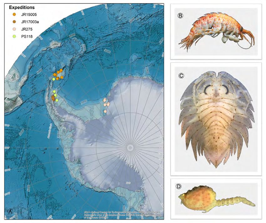
Deep-Sea Life 										                                                                                       Issue 14, January 2020

some of which may be new species, and collected > 180 samples for infaunal community analysis. Every dive revealed
dense coral communities with entirely different species assemblages from those on the slope. We could only survey a
tiny fraction of the seafloor, but if our observations are representative of the > 600 km of the west Florida escarpment,
this may be the largest deep coral province in the Gulf of Mexico.

For more cruise information please go to https://marinelab.fsu.edu/hydrosmac/

                            New deep-sea discoveries from The Bahamas
                                                           Nick Higgs

                                   Director of the Cape Eleuthera Institute, The Bahamas

The Cape Eleuthera Institute (CEI) in The
Bahamas has been a hive of deep-sea
activity in 2019. Two research cruises with
OceanX onboard the Alucia have been
documenting deep-sea fauna of the Exuma
Sound basin down to 1,000 m using their
two submersibles. Previous multibeam
mapping allowed us to make the most
of sub-time to systematically survey the
benthic communities associated with the
steep rocky drop-offs and sedimented
ledges on our doorstep. Large deposits
                                             Figure 1: Exploring the deep walls of the Exuma Sound. Credit: Cape Eleuthera Institute
of seagrass detritus were discovered on
the slopes, suggesting a substantial input of carbon into this non-continental canyon system. We are currently in the
process of analysing video footage and working up samples, including a probable new species of cirolanid isopod.

Night dives on the cruises were used to study the behaviour of bluntnose sixgill sharks (Hexanchus griseus), with the
ultimate goal of deploying a satellite tag to characterise movement at depth of this poorly studied species. These
sharks migrate into shallower water at night, bringing them within reach of the submersible. The team had developed
a modified spear gun system to deploy the tag and after multiple failed attempts (including a grouper that tagged itself
after swimming into the speargun), a shark was finally tagged on the very last dive of the cruise. To our knowledge this
is the first time that a satellite tag has been deployed from a manned submersible at depth. We await results from the
3 month tag deployment.

                                                                  In addition to working with the Alucia, CEI researcher
                                                                  Dr Nathan Robinson accompanied Dr Edith Widder and
                                                                  Dr Sönke Johnsen on a research cruise to the Gulf of
                                                                  Mexico to study mid-water fauna. After analysing >120
                                                                  hours of video footage from the MEDUSA camera system,
                                                                  he spotted something truly remarkable: a giant squid
                                                                  (Architeuthis dux). This footage represents only the second
                                                                  time that these animals have been filmed alive in their
                                                                  natural habitat. Dr Widder is a long-term collaborator of
                                                                  Figure 2: Some of the invertebrate samples recovered from the Exuma Sound.
                                                                  Credit: Eve Moore (Florida Museum of Natural History)

                                                                                                                                          7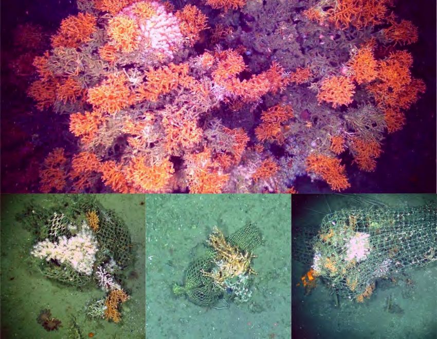
Deep-Sea Life 										                                                                                   Issue 14, January 2020

the Cape Eleuthera Institute and has graciously donated
the MEDUSA system to our institution. We hope to make
many more discoveries in the near future.

We are ideally placed to access the deep-sea habitats of
The Bahamas, which hosts one of the most remarkable
canyon systems in the world, with some of the steepest
slopes plunging ~4,000 m down. If you would like to work
with us in the future, please get in touch.

For more information on our deep-sea research please       Figure 3: A bluntnose sixgill shark investigates the sub during a tagging dive.
contact Nick Higgs (nickhiggs@ceibahamas.org), Director    Credit: OceanX.

of the Cape Eleuthera Institute, The Bahamas or see our
highlights video: vimeo.com/321287408

The science teams on the Exuma Sound cruises included
Dean Grubbs, Sandra Brooke, Charles Messing, Gavin
Naylor, Eve Moore, Oliver Shipley, Lucy Howie-Jordan,
Brendan Talwar, Eric Schneider, Nathan Robinson, Candace
Fields, Valeria Pizarro and Nick Higgs.

                                                           Figure 4: A giant squid caught on camera in the Gulf of Mexico. Credit: Nathan
                                                           Robinson (CEI) and Edie Widder (ORCA)

        The icebreaker Kronprins Haakon explores deep hydrothermal vents
                              under ice in the Arctic
                        Eva Ramirez-Llodra1, Stefan Buenz2 and the HACON cruise team.
                1
                 Norwegian Institute for Water Research, Oslo, Norway, 2 CAGE-Uni. Tromsø, Norway

                                             https://haconfrinatek.com/

On 19 September, a team of 36 scientists and engineers from 9 research institutions (NIVA, Uni. Tromsø, Uni. Bergen,
IMR, WHOI, AWI, Uni. Aveiro and NASA-JPL), together with a writer from National Geographic and film director from
Avatar Alliance Foundation, sat sail from Longyearbyen (Svalbard) towards the high Arctic on the Norwegian ice breaker
Kronprins Haakon (Figure 1). On board we had the recently upgraded hybrid ROV/AUV Nereus Under Ice (NUI, WHOI)

                                                                                                                                        8
Deep-Sea Life 										                                                                                               Issue 14, January 2020

Figure 1: R/V Kronprins Haakon sailing through thin ice between two large ice floes. Photo: E. Ramirez-Llodra, NIVA.

and the towed ocean floor observation and bathymetry system OFOBS (AWI), as well as a CTD, gravity core, multicore,
megacore and plankton net. The aim of the HACON cruise was to investigate the Aurora vent field on the Gakkel Ridge,
located at 83.5°N at 4000 m water depth under ice.

The first black smokers ever to be observed in the Arctic were discovered on
the Aurora seamount, during the Polarstern expedition PS86 led by Prof Antje
Boetius (AWI, Germany). The Gakkel Ridge region, at this time of year, is covered
by large ice floes slowly drifting (most of the time at 0.2-0.4 knots) with incredible
force. The ocean temperatures under the ice are below zero and the terrain on
the seafloor is complex. All this poses considerable challenges and demands on
technology and crew. This was a high-risk, high-gain type of expedition. Anything
could go wrong. But any new observations and samples would greatly increase
our understanding of these remote ecosystems. And we had it all!

We had technological issues, but these only fuelled new collaborations amongst
the engineers from WHOI, AWI and NASA-JPL. So much as to build, from spare
parts, a mini, deep-diving ROV that could go down to 4000 m attached on OFOBS,
giving OFOBS the capacity to “look” around: Sponge Bob Spare Parts (Figure 2).

We faced the challenge of non-collaborative ice floes that would drift on top
of the Aurora vent site limiting our access to it. But the excellent team on the Figure 2: OFOBS (AWI) and Sponge Bob Spare Parts
bridge of the Kronprins Haakon and the cruise lead (with a lot of patience too) being deployed for test in deep water. Photo: E.
                                                                                   Ramirez-Llodra, NIVA.
found ways of getting us on station when the Aurora vent site “came out” under
a large lead of open water or thin ice, so we could operate our deep-diving equipment safely. One of the best days of
the cruise was the first dive of the towed OFOBS system over the vent site. After a very long transect over sedimentary

                                                                                                                                            9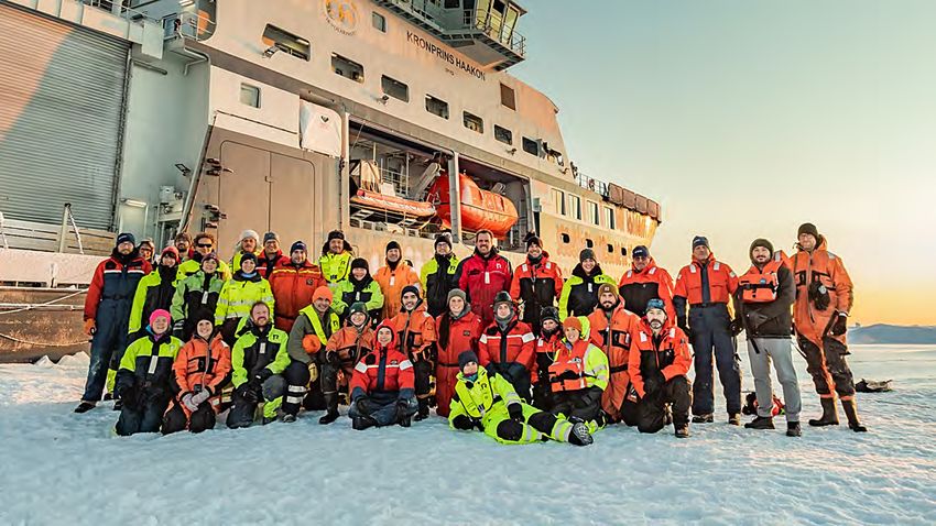
Deep-Sea Life 										                                                                                       Issue 14, January 2020

                                                                            background, we started climbing up a large mound until,
                                                                            to everyone’s excitement and delight, OFOBS flew over a
                                                                            very large black smoker acquiring excellent images of the
                                                                            system (Figure 3). Several more dives were made over the
                                                                            vent field, providing a unique data set of videos and high-
                                                                            definition photographs from which we could identify at
                                                                            least 2 new black smokers.

                                                                            We also made several interesting OFOBS dives around the
                                                                            seamount, showing the variety of habitats in the region,
                                                                            including sediment with rocks colonised by sponges (Figure
                                                                            4) and associated fauna, sinkholes, basalt rocks and rusty
                                                                            soft and coarse sediments on the sulphide mound. These
                                                                            data, together with a wealth of samples taken around the
                                                                            seamount, will greatly contribute to the data collected in
                                                                            2014 and help us understand the processes driving the
                                                                            communities on the Aurora seamount, from viruses and
                                                                            microbes to the sponges that thrive in this region.

                                                                            The scientific institutions represented on the cruise had
                                                                            a focus on life in ice-covered oceans, including ecology,
                                                                            micropaleontology, oceanography and geochemistry.
                                                                            But astrobiology was a completely new topic for many
                                                                            of us. Together with UiT, National Geographic and Avatar
                                                                            Alliance Foundation, the NASA-JPL team took ice-core
Figure 3: The Aurora sulphide mound showing one of the active black smokers
                                                                            samples to investigate if biogeochemical signatures and
observed. Photo: OFOBS/AWI team.
                                                                            microbes from the Aurora vent field might be found in the
overlying ice. The results will contribute to the planning of future projects that aim at exploring for life in other frozen
oceans, such as the ones found on Europa (Moon of Jupiter) or Encedalus (moon of Saturn).

                                                                                                          The HACON cruise was
                                                                                                          high-risk, and we did
                                                                                                          have challenges. But it
                                                                                                          was, without a doubt, a
                                                                                                          successful cruise with an
                                                                                                          excellent atmosphere on
                                                                                                          board (Figure 5). We already
                                                                                                          know much more about
                                                                                                          the Aurora vent field than
                                                                                                          we did before and as the
                                                                                                          sample and data analyses
                                                                                                          progresses in the labs, a
                                                                                                          fuller picture will emerge
                                                                                                          of the composition and
                                                                                                          functioning of this remote
                                                                                                          and pristine ecosystem.
Figure 4: Sponge community on the Aurora seamount. Photo: AWI/OFOBS team.

                                                                                                                                    10
Deep-Sea Life Issue 14, January 2020
Figure 5: The HACON team. Photo: Aleksander Eeg, R/V Kronprins Haakon.
11Deep-Sea Life Issue 14, January 2020
Project Focus
NOAA Office of Ocean Exploration and Research announces
2020 Okeanos Explorer Expeditions
National Oceanic and Atmospheric Administration
Figure 1: Map showing the operating areas (gold polygons) and ports (red diamonds) for expeditions aboard NOAA Ship Okeanos Explorer to be conducted in
FY2020, including the just-completed 2019 U.S. Southeastern Deep-sea Exploration (EX1906 and EX1907). Image courtesy of NOAA Office of Ocean Exploration
and Research.
From October 2019 to September 2020, the NOAA Office of Ocean Exploration and Research (OER) will embark on
NOAA Ship Okeanos Explorer to conduct three regional expeditions starting with the U.S. Southeastern Continental
Margin in Fall 2019, and focusing on the Northern Caribbean and Mid-Atlantic Ridge in 2020. Multidisciplinary teams of
scientists, technicians, and engineers will conduct undersea mapping and ROV explorations of the geological, biological,
oceanographic, and archaeological resources of these ocean areas, the majority of which remain largely unexplored.
These expeditions will contribute to the Atlantic Seafloor Partnership for Integrated Research and Exploration (ASPIRE)
campaign, a major multi-year, multi-national collaborative field program focused on increasing our collective knowledge
of the North Atlantic Ocean in support of the Galway Statement on Atlantic Ocean Cooperation.
The 2019 U.S. Southeastern Deep-Sea Exploration expedition concluded at the end of November, and the ship is now in
12Deep-Sea Life Issue 14, January 2020
a winter repair period until March 2020 when mission operations will resume with sea trials and shakedown operations
off of southern Florida. In Spring of 2020, OER will explore and map deep waters in and around Puerto Rico and test
emerging technologies. This involves collaboration with NOAA’s Office of Coast Survey and will help fulfill a request
from the Meso American-Caribbean Sea Hydrographic Commission (MACHC) to acquire bathymetry in areas with
substantial gaps in coverage.
During the summer of 2020, OER will use NOAA Ship Okeanos Explorer to conduct a 70-day Voyage to the Ridge
expedition to characterize unexplored areas of the Mid-Atlantic Ridge and the Azores Plateau. In addition to supporting
science and management priorities of this region, this expedition will also address other ASPIRE priorities, such as
leveraging international partnerships to conduct coordinated exploration across the North Atlantic Ocean in support of
Galway. ROV and mapping operations conducted during this expedition will complement previous and upcoming work
in the region. Mapping operations will target seafloor and water column areas with little or no high-quality sonar data
and support follow-on ROV operations. ROV dives will characterize hydrothermal vents, deep-sea coral and sponge
communities, fracture zones, and rift zones.
Following the Voyage to the Ridge expedition, OER will conduct a 15-day transit mapping mission on the NOAA Ship
Okeanos Explorer to fill data gaps in multibeam bathymetry coverage in support of Seabed 2030, ASPIRE priorities, and
critical marine mineral inventory initiatives. Transit mapping will be planned to match and expand existing track lines
en route to home port in North Kingstown, Rhode Island.
Throughout the year, telepresence technology will allow you to follow discoveries via the NOAA Office of Ocean
Exploration and Research website. NOAA is currently seeking scientists and managers interested in actively
participating during 2020 expeditions. For details on opportunities to get involved, please visit this page. If you are
interested in providing input into expedition planning or participating as a scientist or student, please contact the
Expeditions Science Advisor, Dr. Scott France, at france@louisiana.edu.
Review - From Surface to Seafloor: Exploration of the Water Column
Aria Ritz Finkelstein
September 23, 2019
We still have much to learn about the dynamics and structure of the water column from the surface of the sea down
to the seafloor. Our knowledge of the organisms that populate this space is far from complete, as is our understanding
of how human activities will influence it. Recently, NOAA held a workshop with the goal of answering a number of
questions: What lives in the water column? What are the “biodiversity, biogeography, ecology, and behavior” of
organisms in the water column, and what is its structure? Second, what is the water column’s structure? How do
anthropogenic activities influence this structure and these organisms? Finally, how do we communicate the importance
of this knowledge to both the general public and policymakers?
The workshop’s result was a report outlining a broad, diverse range of research tools and potential collaborations. The
report identifies unexplored regions, biodiversity hotspots, intersections between two very different environments,
and places where the seafloor is already well understood as priorities for water column research. And, it lists the
data to collect in order to understand both the current state of these regions and their variability across spatial and
temporal scales.
There are a number of ways to collect each type of data—from chemical and physical characteristics to single cell
biology to multicellular organisms all the way up to more complex data such as food webs, long-range tracking, and
13Deep-Sea Life Issue 14, January 2020
responses of animals to their environments. Long-term observation networks are important for understanding basic
physical features—temperature, salinity, chemical levels, and so on. These can be ship-based, but they can also be
floating, moored, or attached to stationary platforms. They can also take advantage of other already existing resources
to piggyback research onto operations such as drilling ships. Remotely operated vehicles (ROV) are more useful for
gathering in situ data about organisms—especially delicate ones—and the relationship between their distribution and
physical and chemical conditions. There are many less traditional, autonomous systems too, including sensors mounted
on animals, autonomous underwater vehicles (AUVs), and floating platforms with new capabilities like collecting eDNA
samples. The main obstacles in the way of using these are battery power, biofouling, and the difficulty of ground-
truthing, and these are areas that offer much room for innovation.
To map a way forward, the workshop participants developed a six-piece plan to develop a water column exploration
program. First, the group will prioritize questions and key regions. Second, they will collect data from already existing
and implemented sensors and expeditions. Third, they will use the prioritized questions to guide the development of
new technologies. Fourth, they will dedicate ships to collect midwater samples. Fifth, they will standardize sampling and
data management protocols. Sixth, they will prepare research infrastructure to respond quickly to anomalous events,
because understanding the water column under perturbation or unusual conditions can be as useful as understanding
its «normal state». Finally, as important as these structural and technical questions are, perhaps the most important
task the workshop participants discussed is the work of communicating the importance of their research to the general
public and to policymakers.
DY108: Return to the Darwin Mounds, the UK’s 1st deep-sea MPA
Brian Bett1*, Veerle Huvenne1*, et al.
National Oceanography Centre, UK
1
*Correspondence: bjb@noc.ac.uk, viah@noc.ac.uk
September found us returning to the Darwin Mounds for our sixth look at these cold-water coral systems. In the now
21-year time span since we discovered the site, we have documented its degradation by bottom trawling, contributed
to its designation and protection as the UK’s first deep-sea Special Area of Conservation (SAC), and begun the process
of monitoring its progress. In the course of RRS Discovery cruise 108 we were able to confirm the continuing good
status of corals in the West Field, the continuing poor condition of corals in the East Field, and the occurrence of
particularly good coral frameworks in the Pocket Field (Figure 1, upper image), last imaged in 2000.
In broad terms, little appeared to have changed since our last visit in 2011, at which time the ban on bottom
contact fisheries (initiated in 2003) appeared to have been effective, but there was little if any evidence of coral
recruitment or regrowth in the impacted East Field (see Huvenne et al., 2016. Biol. Conserv., 200: 60-69. doi:10.1016/j.
biocon.2016.05.030). Highlights of DY108 included – the good news that settlement plates, and their moorings,
deployed in 2011 and recovered during the cruise had very healthy epigrowth including corals (Desmophyllum spp.) –
and the bad news that macroplastic debris continues to stand on the Darwin Mounds coral frameworks in significant
quantities, notably lost / discarded fishing gear (Figure 1, lower images).
DY108 was funded by the UK Natural Environmental Research Council’s Climate Linked Atlantic Sector Science (CLASS)
project that enables us to carry out time-series research at the Darwin Mounds SAC, the Greater Haig Fras Marine
Conservation Zone (MCZ; see Benoist et al., 2019. Conserv. Biol., 33: 1174-1186. doi:10.1111/cobi.13312) in the Celtic
Sea, the Whittard Canyon MCZ, and the long-running Porcupine Abyssal Plain Sustained Observatory. The cruise was
further boosted by a joint venture with the University of Southampton’s Ocean Perception team and their BioCam
14Deep-Sea Life Issue 14, January 2020
system described in the previous DY109 article
Figure 1 (top). Healthy coral framework from the Darwin Mounds Pocket Field. (bottom): Fishing gear remnants stranded on Darwin Mounds corals. © NOC, 2019.
Influence of ice cover and latitude on Antarctic peracarid crustaceans in a
changing environment
Davide Di Franco1, Katrin Linse2, Huw Griffiths2, Angelika Brandt1
1
Senckenberg Naturmuseum, Senckenberganlage 25, 60325 Frankfurt am Main; 2British Antarctic Survey (BAS), High
Cross, Madingley Road, CB3 0ET, Cambridge, United Kingdom
During the expedition PS118 (February 2019) and in the framework of the project Larsen-C PEARL, the RV Polarstern
sailed towards the western Weddell Sea, east of the Antarctic Peninsula. There, on the 12th of July 2017, a huge
portion of ice (iceberg A68) had calved from the Larsen-C Ice Shelf, exposing the underlying seafloor for the first time to
new environmental conditions. The aim of the project was to investigate the communities of macrobenthic peracarid
crustaceans (Malacostraca; Figure 1B, 1C, 1D) which lived under the ice shelf and assess the influence of the latter on
their diversity and abundance.
The project was driven by the hypothesis that peracarid faunal assemblages that live beneath an ice shelf likely
comprised assemblages resembling those from the deep Weddell Sea.
15Deep-Sea Life Issue 14, January 2020
Figure 1: Expeditions and sampling stations (A); Amphipoda, Eusirus perdentatus Chevreux, 1912 (B); Isopoda, Ceratoserolis trilobitoides (Eights, 1833) (C);
Cumacea, Campylaspis G.O. Sars, 1865 (D).
For this purpose, deep-sea samples of the peracarid fauna collected during previous expeditions in the Weddell Sea and
in other Antarctic areas characterised by different extents of ice-cover are also available for direct comparison (Figure
1A): the ice free area of the South Orkney Islands (JR15005), Prince Gustav Channel (JR17003a) in which the ice-shelf
collapsed in 1995 and the seasonally ice-covered Filchner Trough (JR275). Unfortunately, neither during expedition
JR17003a with RRS James Clarke Ross, nor during expedition PS118 with RV Polarstern was it possible to reach the
Larsen-C area due to heavy ice conditions. Therefore samples were collected in alternative locations along the eastern
Antarctic Peninsula, following a latitudinal gradient and leading to new scientific questions.
The aim of the project is to investigate the influence of ice cover and latitude on peracarid abundance and species
composition comparing areas characterised by different ice cover regime and latitudinal gradients. Besides we plan
to investigate the influence of other environmental parameters (e.g. depth, temperature, salinity, type of sediments,
primary production) and evaluate which functional groups of selected peracarid taxa may exist or dominate under
different environmental conditions.
Collected data from Prince Gustav Channel and the comparison with samples from the deep Weddell Sea and the other
study areas will also still allow us to evaluate the main hypothesis assessing the effect of the ice shelf and its collapse
on peracarid faunal assemblages.
The results of the project will improve our knowledge on how components of the benthic community interact with
16Deep-Sea Life Issue 14, January 2020
the abiotic factors of their inhabiting environment. They will also provide useful information on how possible changes
of such parameters could influence their present distribution and diversity. Ultimately, a better understanding of the
aforementioned interactions might help to predict the ecological impact induced by the on-going climate change.
Taking Stock of STRONG High Seas Project two years on
Lewis Kihumba1, Ben Boteler2 and Carole Durussel2
Birdlife International, 2STRONG High Seas Project
1
As the world grapples with a myriad of environmental challenges including climate change, focus is shifting to another
environmental frontier that requires urgent collective attention and action - Areas Beyond National Jurisdiction (ABNJ),
commonly defined as areas extending more than 200 nautical miles from coastlines. ABNJ cover about two thirds of the
world’s oceans and account for a significant proportion of the planet’s biodiversity, from planktons to whales. Moreover,
they hold more than 90% of the world’s fish stocks and play a crucial role in the regulation of climate by absorbing
carbon dioxide from the atmosphere, thus slowing impact of climate change. Human activities are increasingly putting
pressure on biodiversity in ABNJ. Further aggravating the situation is a fragmented legal and institutional framework
to regulate activities in these jurisdictions. In addition, Sustainable Development Goal (SDG) 14 underlines the need
for sustainable use of oceans, seas and marine resources for sustainable development, highlighting the importance of
oceans, including ABNJ.
The STRONG High Seas (Strengthening Regional Ocean Governance for the High Seas) project funded by the German
Federal Ministry for the Environment, Nature Conservation and Nuclear Safety (BMU) through the International Climate
Initiative (IKI) focusses on conducting scientific assessments and supporting dialogue to contribute to the development
of effective frameworks and approaches for ocean governance in the Southeast Pacific and Southeast Atlantic regions,
as well as contributing to the ongoing negotiations for a global legally binding treaty on marine biodiversity in areas
beyond national jurisdiction (BBNJ) conducted under the United Nations. The project also facilitates dialogue between
various stakeholders, including national and regional authorities, academia, science institutions in addition to NGOs in
order to develop a collaborative approach towards governance measures for the sustainable use of marine biodiversity
and effective management of ABNJ. Moreover, it provides a platform for stakeholders to deliberate on challenges
facing governance of ABNJ, facilitate knowledge exchange while at the same identifying areas for further collaboration.
A number of organizations in the two regions have area-based management tools (ABMTs), including marine protected
areas (MPAs), and marine spatial planning (MSP), among others. However, these tools are only applicable within the
jurisdiction of countries that have developed them and not in ABNJ. The dialogue workshops in the two regions will
be instrumental in development of a cross sectoral ecosystem-based approach. Since the project’s inception in 2017,
a number of dialogue workshops have been held including inter regional workshops, with more dialogues planned by
2022. Through established working groups, it is hoped that these dialogues will be able to promote the exchange of
ideas and enable the development of feasible ocean governance frameworks. Additionally, cross-sectoral management
approaches will be instrumental in streamlining regional ocean governance. Capacity building among key sectoral
organizations is integral in the Southeast Pacific and Southeast Atlantic regions. Sectoral organizations are benefitting
from technical support, trainings, and workshops being held in the two regions to increase ability of these organizations
to address and respond to High Seas governance issues. It is envisaged that through these exchanges, ocean governance
in the two regions’, ABNJ can be strengthened and effectively contribute to a global instrument under the United
Nations Law of the Sea Convention (UNCLOS) framework.
Author Profiles:
17Deep-Sea Life Issue 14, January 2020
Lewis Kihumba is communication lead at Birdlife International one of the Strong High Seas project
implementation partner in Africa. He is the communications focal point for the STRONG High Seas Project
in the South East Atlantic region.
Ben Boteler is one of the co-leads of the STRONG High Seas project and is conducting research in an effort
to advance and strengthen regional ocean governance for the high seas in the South East Atlantic and
South East Pacific as well as globally. In particular, his focus is on the socioeconomic uses and benefits
obtained from the marine environment.
Dr. Carole Durussel conducts research to advance and strengthen regional ocean governance, with a
particular focus on the legal and institutional framework for the conservation and sustainable use of
marine biodiversity in ABNJ. She is the co-lead of the STRONG High Seas project.
Website: https://www.prog-ocean.org/our-work/strong-high-seas/
Publication of first UK deep-sea biotope sensitivity assessments
Ellen Last, Charlie Howarth & Laura Robson
Joint Nature Conservation Committee, Peterborough, UK
Corresponding author: ellen.last@jncc.gov.uk
The Joint Nature Conservation Committee (JNCC) has
recently been undertaking sensitivity assessments
for deep-sea biotopes from the Britain and Ireland
Habitat classification. The first assessments are now
published on the MarLIN website for Leptometra celtica
assemblages, found on Atlantic upper/mid bathyal sand
and coarse sediments. Assessments for Geodia and other
massive sponges, found on Atlanto-Arctic upper bathyal
coarse and mixed sediments are currently in press. The
assessments follow the Marine Evidence-based Sensitivity
assessment (MarESA) method, which involves a detailed
literature review, and each assessment has been through
a peer-review process involving deep-sea experts.
The assessments provide resistance, resilience and overall sensitivity scores for each of the biotopes to a range of
hydrological, physical, biological and chemical pressures. Climate change pressures have also been assessed for a
number of biotopes as part of a separate project (also available on the MarLIN website). A selection of pressures for
the ‘Leptometra celtica assemblages’ sensitivity assessment are discussed below.
Information on the ecology and biology of Leptometra celtica was collated to help determine potential resilience
(the rate of, or time taken for, recovery once the pressure has abated or been removed). Although the species can
regenerate lost or damaged arms, as well as having the ability to crawl or swim short distances, modelled data showed
that the species has a short pelagic duration (Gallego et al., 2013), meaning that recovery could take between 2-10
years.
Evidence on the effects of ‘Litter’ on Leptometra celtica indicated that individuals may get entangled in relict fishing
18Deep-Sea Life Issue 14, January 2020 gear (Oliveira et al., 2015). However, a fishing net was also found to act as a fixation point for the species, providing an advantageous position for filter feeding. Resistance was therefore assessed as ‘Medium’, giving an overall sensitivity of ‘Medium’. Evidence on the effects of ‘Abrasion/disturbance of the surface of the substratum or seabed’ was mainly based on the Mediterranean congeneric spp. Leptometra phalangium. One study found aggregations of this species either side of a trawling lane, with solitary individuals on the raised banks of trawl-door plough marks (Smith et al., 2000). Another study only found the species in areas of less intensive fishing (Mangano et al., 2013). The resistance of Leptometra celtica was hence deemed to be ‘None’. As the species is likely to recover within 2-10 years (i.e. ‘Medium’ resilience), overall sensitivity was considered as ‘Medium’. For the pressure ‘Smothering and siltation rate changes’, the feeding and respiratory surfaces of Leptometra celtica may become clogged. However, the species is thought to have the ability to compensate by shaking its arms. Individuals may also raise up and extend their arms, and/or use their cirri to raise themselves up above the substratum, allowing them to filter feed. Therefore, Leptometra celtica assemblages were assessed as ‘Not sensitive’ at this pressure benchmark (deposition of
Deep-Sea Life 										                                                                                                   Issue 14, January 2020

species can now be compared with actual photographs of previously caught specimens instead of with beautifully
drawn illustrations from popular market books,” he says. “And the guide makes it easier for fishery researchers to study
this group of species. Until now, they have been entirely dependent on scientific determination collections that were
difficult to access”.

The manual was compiled as a draft version by Bas Schilling, a student at Van Hall Larenstein University of Applied
Sciences, and was subsequently completed by researchers at Wageningen Marine Research. It is also available as a PDF.

                               Deep-Sea Lebanon Project:
              Results of the 2016 Expedition Exploring Submarine Canyons

                       Towards Deep-Sea Conservation in Lebanon Project
                                                     Mira Husseini & Ziad Samaha

                             IUCN ROWA (Regional Office for West Asia), Lebanon Project Office

Marine sand and gravel extraction, sewage discharge and oil dumping, unsustainable and illegal fisheries, habitat
degradation, recreational uses, coastal urbanisation, invasive species, and larger-scale impacts such as the effects of
climate change, are threatening the Lebanese marine ecosystem. Marine Protected Areas (MPAs) are an effective tool
to protect marine biodiversity, and support human wellbeing and sustainable development.

However, Lebanon suffers from a lack of information about marine habitats and species, which obstructs MPAs
designation and management. Closing this knowledge gap was the primary aim of the Deep-Sea Lebanon project,
which performed the first biological survey of deep-sea Lebanese waters. The Lebanese deep-sea canyons have
been identified as Ecologically or Biologically Significant Areas (EBSA) because of their important role in ecosystem
functioning, their uniqueness and rarity, and their special importance for life-history stages of the species that they

            Figure 1 (top row): Demosponge in rocky seabed with coralligenous. Batroun, Lebanon; Lionfish (Pterois miles) among
            coralligenous. Batroun, Lebanon; Mediterranean moray (Muraena helena). Batroun, Lebanon. (bottom row) Seven-armed starfish
            (Luidia ciliaris). Saint George canyon, Lebanon; Tube anemones (Cerianthus membranaceus). Jounieh, Lebanon; Crab (Bathynectes
            maravigna) and striped soldier shrimps (Plesionika edwardsii). Jounieh.

                                                                                                                                              20
Deep-Sea Life Issue 14, January 2020
host, among other characteristics.
The biological survey of deep-sea Lebanese waters was carried out in five areas: Tarablus/Batroun, Jounieh, St.
George, Beirut escarpment, and Sayniq. The survey identified six main habitats over a broad depth range (36-1050m):
coralligenous habitats and rhodolith/ maërl beds; rocky bottom areas; muddy and sandy-muddy bottoms; sandy
bottoms; canyon heads; and bathyal muds. 622 taxa were documented, among which three species that are likely to
be new to science: a sponge belonging to the genus Axinella, a starfish belonging to the genus Luidia, and a stony coral,
which is pending identification, but likely belonging to the genus Anomocora.
Dozens of species that have not previously been recorded in Lebanon were observed. The glass sponge (Farrea
bowerbankii), the rabbitfish (Chimaera monstrosa), the velvet-belly lanternshark (Etmopterus spinax), holothurians
such as Mesothuria intestinalis and Penilpidia ludwigi, and cnidarians such as the gorgonian Swiftia pallida, sea pens
(e.g., Pennatula rubra, Virgularia mirabilis, and Funiculina quadrangularis), and species of the subclass Hexacorallia,
such as Sideractis glacialis and the tree coral Dendrophyllia ramea. Three species of starfish were spotted, previously
not recorded in the Mediterranean Sea: Hacelia superba on bathyal rocky bottoms, Leptasterias sp. on ancient fossil
reefs, and a species of the genus Luidia, abundant on sandy bottoms in the circalittoral zone.
MPAs are a management tool to limit localised threats to these important systems, including impacts from fisheries,
marine litter, invasive species and oil exploratory activities that directly or indirectly damage them.
Lebanon should prioritise the conservation of coralligenous concretions and rhodolith/maërl beds, because of their
vulnerability to anthropogenic impacts. There is the need to grant coralligenous habitat and maërl beds the same
degree of legal protection as Posidonia oceanica meadows, possibly using the tools of the Barcelona Convention. As a
party to the Barcelona Convention Lebanon should ensure that, fossil reefs are managed under the same framework as
other ‘dark habitats’, to ensure that threats to these systems are minimised or avoided altogether. All pennatulaceans
should be included as habitat builders under the Mediterranean Action Plan for protecting dark habitats. The red sea
pen (P. rubra) is particularly diffuse and considered as one of the key deep-sea community types in Lebanon. The tall
sea pen (F. quadrangularis) should be protected not only in Lebanese waters. Lebanon should take legal steps to ensure
the protection of these habitats and limit the challenges they face.
Further information: https://www.iucn.org/regions/west-asia/projects/completed-projects/towards-deep-sea-
conservation-lebanon-project
First results of the Project “Deep-sea soft-bottom benthic communities:
Exploring biogeography and genetic connectivity of southeast Pacific
Seamounts”
Eulogio Soto1, Eduardo Quiroga2, Jeroen Ingels3, Charlotte Seid4, Joseph Horacek3, Natalia Catalán5,
Jaime Romero5 and Dhugal Lindsay6
1
Universidad de Valparaíso, 2Pontificia Universidad Católica de Valparaíso, 3Florida State University, 4Scripps
Institution of Oceanography, 5Universidad de Chile, 6Jamstec
Between January 27th and March 2nd 2019, the oceanographic cruise MR18-06 “East/central Pacific International
Campaign (EPIC)” aboard the R/V Mirai, JAMSTEC was carried out from Valparaiso, Chile to Tahiti, French Polynesia.
Seven study sites (Figure 1) were successfully sampled using a Multicore. Core samples with surficial sediments (columns
up to 40 cm) were obtained from the Atacama Trench (7742 m depth, Figure 2) and at the base of different seamounts
21Deep-Sea Life Issue 14, January 2020 Figure 1. Sampling stations (SPG1 to SPG7) where sediment samples were collected. (depths between 2895 and 4114 meters) located inside the jurisdiction of Marine Protected Areas belonging to Chile as well as in the high seas (Figure 1). Live-sorting of macrofauna from the upper ~5 cm of a subset of sediment cores yielded very few organisms (average ~2 per core), chiefly polychaetes and copepods (Figure 3). Analysis of the remaining cores has not yet been completed. Meiofaunal samples contained very low abundances of organisms (
Deep-Sea Life 										                                                                                                           Issue 14, January 2020

Cloroflexi, Plactinomycetes, Actinobacteria and Gemmatimonadetes.

Manganese crusts and nodules were collected at SPG 2 and SPG5 (Figure 6), some of them containing possible
evidence of invertebrates (cnidarians, bryozoans) on their surfaces. The geological characterization of these minerals
is in progress.

The oxide-reduction potential (ORP) in sediments ranged from 409 mV to 572 mV, while pH ranged from 7,23 to 7,43.
Gran size, organic content, isotopes and others geochemical parameters are being analysed.

Results are expected to improve our knowledge and understanding of biodiversity, biogeography and geochemistry of
seafloor from one of the most unexplored regions in the world.

Authors thank the funds provided by The Pew Charitable Trusts. However funding is highly required and necessary for
samples analysis, shipment and results outreach.

The project is led by Dr. Eulogio Soto and Dr. Eduardo Quiroga. Contact details: eulogio.soto@uv.cl and eduardo.
quiroga@pucv.cl

                   Coral Reefs on the High Seas Coalition:
Supporting the establishment of the first marine conservation areas to protect
                   mesophotic coral reefs on the high seas
                                                                      Daniel Wagner

                                                              Conservation International

In May 2019, a group of experts in ocean science, policy, law, and communications convened in Denver, Colorado to
launch the Coral Reefs on the High Seas Coalition, a global alliance of partners that seeks to support the establishment
of the first large-scale marine conservation areas that would protect coral reefs in marine areas beyond national

Potential mesophotic coral reefs on the high seas based on the global distribution data of seamounts and knolls (Yesson et al. 2011).

                                                                                                                                                      23
Deep-Sea Life Issue 14, January 2020
jurisdiction. Specifically, the coalition seeks to support high seas conservation efforts by generating the scientific
evidence base and developing the strategic communications that are necessary to advance international awareness
and action for these unique and fragile ecosystems.
Marine areas beyond national jurisdictions, commonly known as the high seas, cover over 61% of the global oceans
by area and over 73% by volume. These vast ocean areas provide many vital ecosystem services that are critical for
sustaining life on our planet. Yet, only 1.2% of the high seas currently lie within marine protected areas, in large part
due to the patchwork of a legal framework that is currently in place to protect the high seas, as well as the lack of
awareness that important ecosystems exist within these remote ocean areas.
Coral reefs have been heralded as the rainforests of the sea due to their remarkably high levels of biodiversity, and as
a result, have a long history of protection in the exclusive economic zones (EEZ) of many countries. While most people
assume that coral reefs only exist in shallow and nearshore waters, deeper extensions of tropical coral reefs, known as
mesophotic coral ecosystems, have been documented down to depths of 150m in many remote locations, including
on the high seas. Global seamount inventories, available seafloor mapping data, and habitat suitability models suggest
that there are several seafloor areas in the high seas that are suitable for mesophotic coral reefs, with almost none of
these having been explored scientifically.
The Coral Reefs on the High Seas Coalition will work with several partners over the next two years to conduct scientific
exploration of high seas coral reefs, link research results into protected area design, raise political support, and
advance international policy for these irreplaceable ecosystems. Planned coalition activities include several research
expeditions, the first of which will explore mesophotic reefs on seamounts around Rapa Nui (Easter Island) early in
2020. For more information contact dwagner@conservation.org.
Coral reef off Salas y Gomez Island in the Chilean EEZ explored by a National Geographic expedition in 2011. Over 20 seamounts with summits shallow enough to
host MCEs exist in high seas waters around the Salas y Gomez and Nazca Ridges. The Coral Reef of the High Seas Coalition will work with several partners to explore
such areas in the next two years. (Photo courtesy of Enric Sala, National Geographic Society).
24You can also read