DISASTER BEFORE AND AFTER THE - Eos.org
←
→
Page content transcription
If your browser does not render page correctly, please read the page content below
VOL. 102  |  NO. 3
                  MARCH 2021
                                        The Beringia Standstill

                                              Dirty Trees Feed
                                              the Water Cycle

                                           Safe—and Sticky—
                                                Lava Studies

 BEFORE AND
  AFTER THE
DISASTER
For a burgeoning group of scientists
building equity into hazard research,
  people are a crucial—and often
        missing—data point.
FROM THE EDITOR
Editor in Chief
Building Equity Heather Goss, Eos_EIC@agu.org
AGU Staff
into Hazard Research Vice President, Communications, Amy Storey
Marketing,and Media Relations
“T
here is growing recognition that the effects of Editorial
Manager, News and Features Editor Caryl-Sue Micalizio
natural hazards are unequally distributed across
Science Editor Timothy Oleson
the population and that certain communities face News and Features Writer Kimberly M. S. Cartier
greater challenges in accessing resources to prepare for, News and Features Writer Jenessa Duncombe
respond to, and recover from disasters,” said Michelle Hum-
Production & Design
mel, an assistant professor at the University of Texas at
Manager, Production and Operations Faith A. Ishii
Arlington and the Eos Science Adviser from AGU’s Natural Production and Analytics Specialist Anaise Aristide
Hazards section. Hummel proposed the idea for our March Assistant Director, Design & Branding Beth Bagley
Senior Graphic Designer Valerie Friedman
issue theme on increasing equity in the way we deal with haz-
Senior Graphic Designer J. Henry Pereira
ards and disasters.
We reached out to scientists across a spectrum of fields who Marketing
are all working toward the same goal. Alessandra Jerolleman Communications Specialist Maria Muekalia
Assistant Director, Marketing & Advertising Liz Zipse
writes on page 21 about the need to better understand how
disasters hit rural areas. These communities often have outdated building and zoning codes Advertising
and face administrative challenges in applying for aid but can also be exceptionally adaptable Display Advertising Steve West
because of a strong sense of self-reliance. On the whole, policymakers just don’t have enough steve@mediawestinc.com
Recruitment Advertising recruitmentsales@wiley.com
social science research to incorporate with geohazard data to better assist these areas. Jerol-
leman offers several approaches for scientists and local leaders to follow.
Science Advisers
Eric Tate and Christopher Emrich are providing a great example of just this kind of approach.
Geomagnetism, Paleomagnetism, Julie Bowles
On page 24 they discuss their work incorporating social vulnerability assessments into hazard and Electromagnetism
models. They aim to inform better mitigation planning as well as recovery programs. Our Space Physics and Aeronomy Christina M. S. Cohen
Cryosphere Ellyn Enderlin
reporting on that intersection of science and policy in “Natural Hazards Have Unnatural
Study of the Earth’s Deep Interior Edward J. Garnero
Impacts—What More Can Science Do?” on page 36 also looks at better mitigation efforts. Geodesy Brian C. Gunter
“I was really encouraged to learn about FEMA’s Building Resilient Infrastructure and Com- History of Geophysics Kristine C. Harper
Planetary Sciences Sarah M. Hörst
munities program, which focuses on predisaster mitigation and incentivizes projects that
Natural Hazards Michelle Hummel
account for social vulnerability and future climate change,” said Hummel. “This is a great Volcanology, Geochemistry, and Petrology Emily R. Johnson
example of how scientists and policymakers can come together to pass forward-looking leg- Societal Impacts and Policy Sciences Christine Kirchhoff
islation that helps communities prepare for future hazards.” Seismology Keith D. Koper
Tectonophysics Jian Lin
Finally, we take a look at the Global Earthquake Model Foundation in Italy on page 30. The Near-Surface Geophysics Juan Lorenzo
group’s mission is to make the world more resilient to earthquakes, and a crucial part of that Earth and Space Science Informatics Kirk Martinez
is incorporating the human element into their model. Read more about their enormous under- Paleoceanography and Paleoclimatology Figen Mekik
Mineral and Rock Physics Sébastien Merkel
taking to collect information on population locations, economic compositions, building den- Ocean Sciences Jerry L. Miller
sity, and zoning codes around the world—and then put every last bit into a simulation to shake Global Environmental Change Hansi Singh
around. Education Eric M. Riggs
Hydrology Kerstin Stahl
I’d like to thank Tiegan Hobbs and Leah Salditch, who are leading a new Hazards Equity Tectonophysics Carol A. Stein
Working Group at AGU. “The group focuses on how science can be used to help communities Atmospheric Sciences Mika Tosca
and policymakers address the need for equity in natural disaster mitigation,” said Hummel. Nonlinear Geophysics Adrian Tuck
Biogeosciences Merritt Turetsky
“It also explores ways by which its efforts may help in fostering participation and inclusion of
Hydrology Adam S. Ward
underrepresented groups in natural hazards science and increasing the diversity of the natu- Diversity and Inclusion Lisa D. White
ral hazards community.” Earth and Planetary Surface Processes Andrew C. Wilcox
Atmospheric and Space Electricity Yoav Yair
Hobbs and Salditch, along with Hummel, directed us to many of the scientists doing import-
GeoHealth Ben Zaitchik
ant work in this area who are featured in this issue. We’re proud to highlight their work and
look forward to seeing how this movement grows.
©2021. AGU. All Rights Reserved. Material in this issue may be photocopied by
individual scientists for research or classroom use. Permission is also granted
to use short quotes, figures, and tables for publication in scientific books and
journals. For permission for any other uses, contact the AGU Publications Office.
Eos (ISSN 0096-3941) is published monthly by AGU, 2000 Florida Ave., NW,
Washington, DC 20009, USA. Periodical Class postage paid at Washington, D.C.,
and at additional mailing offices. POSTMASTER: Send address changes to Member
Service Center, 2000 Florida Ave., NW, Washington, DC 20009, USA
Member Service Center: 8:00 a.m.–6:00 p.m. Eastern time; Tel: +1-202-462-6900;
Fax: +1-202-328-0566; Tel. orders in U.S.: 1-800-966-2481; service@agu.org.
Heather Goss, Editor in Chief
Submit your article proposal or suggest a news story to Eos at bit.ly/Eos-proposal.
Views expressed in this publication do not necessarily reflect official positions
of AGU unless expressly stated.
Randy Fiser, Executive Director/CEO
SCIENCE NEWS BY AGU // Eos.org 1
CONTENT
30
24 36
Features
24 Assessing Social Equity 30 Where Do People Fit
in Natural Disasters into a Global Hazard Model?
By Eric Tate and Christopher Emrich By Richard J. Sima
Incorporating vulnerability studies into hazard This earthquake simulation incorporates your census
research can reveal the inequities in mitigation data and a whole lot more.
and response.
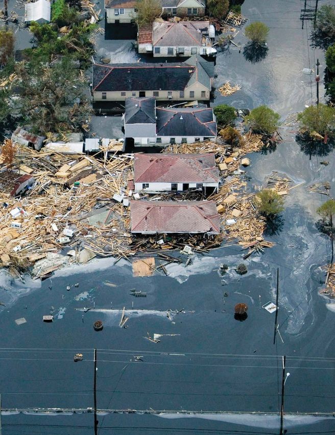
36 Natural Hazards Have
On the Cover Unnatural Impacts—What
A sign near the ocean in Lima, Peru, warns of danger
in a tsunami hazard zone. Credit: ©Morganeborzee/
More Can Science Do?
Dreamstime.com By Korena Di Roma Howley
“The approach we were taking was extremely
ineffective and also extremely unjust.”
2 Eos // MARCH 2021
CONTENT
11 19
14 44
Columns
From the Editor Opinion
1 Building Equity into Hazard Research 19 How to Combat Bullying and Discrimination
in the Geosciences
News 21 Building Resilience in Rural America
5 Overturning in the Pacific May Have Enabled
a “Standstill” in Beringia Research Spotlight
6 Modeling the Creation of Cratons, Earth’s Secret 42 Tracking How Plastic Moves in the Coastal Ocean
Keepers 43 A Census of Snowdrifts in Northern Alaska | Drivers
7 European Colonists Dramatically Increased of Upper Atmosphere Climate Change
North American Erosion Rates 44 New Insights into Uncertainties About Earth’s Rising
8 To Make Better Hurricane Models, Consider Temperature | A New Approach to Characterizing
Air Pollution Space Plasmas
9 Corn Syrup Reveals How Bubbles Affect Lava’s Flow
10 Waterways Change as Nearby Cities Grow
11 Dirty Trees Shape Earth’s Hydrologic
Positions Available
and Carbon Cycles 45 Current job openings in the Earth and space sciences
12 New Volcano, Old Caldera
14 Long-Term Drought Harms Mental Health
in Rural Communities
Postcards from the Field
16 Tracing the Moisture That Nourishes the World’s 49 A glimpse of the otherworldly “lakescape” at the
Highest Glacier bottom of the Middle Island Sinkhole in Lake Huron.
17 Earth’s Magnetic Field HoldsClues to Human History
AmericanGeophysicalUnion @AGU_Eos company/american-geophysical-union AGUvideos americangeophysicalunion americangeophysicalunion
SCIENCE NEWS BY AGU // Eos.org 3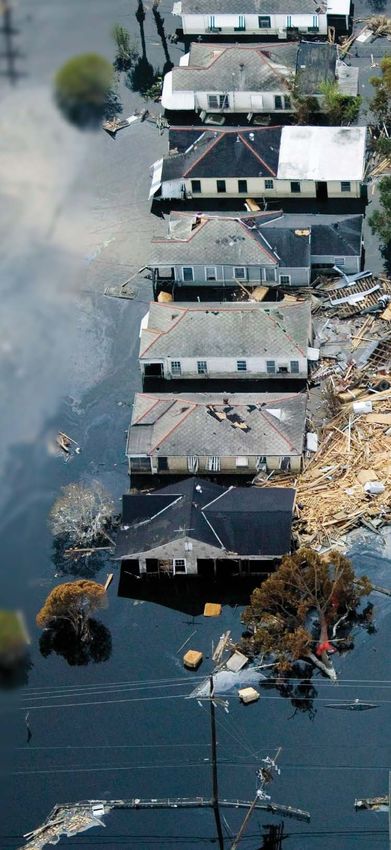
4 Eos // MARCH 2021

NEWS
Overturning in the Pacific May Have Enabled
a “Standstill” in Beringia
Rae thinks his results confirm the exis-
tence of a PMOC. Running the climate models
with a PMOC showed that the ocean’s surface
layer would become depleted in nutrients
because it would consist of water from the
subtropics, where year-round stratification
and unfavorable wind stress restrict nutrient
supply from below. And indeed, cores taken
from shallower depths, from the Asian and
American continental slopes and from the
flanks of seamounts, had so far shown that
during the LGM the surface water of the North
Pacific contained fewer nutrients than it does
The forbidding Bering Strait, which today separates Asia (left) and North America, may once have had a warmer today.
climate that allowed for settlement. Credit: SeaWiFS Project, NASA/Goddard Space Flight Center, and ORBIMAGE
Beringian Standstill
and Human Migration
Rae happened to read an article about the
P
lanet Earth pulled out all the stops, it ional overturning circulation (PMOC) pattern Beringian Standstill in Science (bit . ly/
seems, to enable the first humans to was active. The proposed PMOC functioned Beringian-standstill) and applied his results
reach North America. When a glacial much like the Atlantic version, the AMOC, to the concept. “I became aware of this idea
period lowered sea levels and turned parts of which today gives western Europe its temper- that people may have lived in Beringia in the
the Bering Strait into a land bridge, a warm ate climate. The AMOC is driven by cold and peak of the last Ice Age. And there is some
ocean current shielded that region from the salty, and hence dense, water sinking near indication from pollen and things like fossil
worst cold, turning it into a refuge where the Arctic, pulling in warm surface water from beetles that the climate there might have
ancestors of the first Americans found shelter the south while itself streaming southward been surprisingly mild,” he said.
for thousands of years. below the surface currents. Rae’s models showed that the PMOC
Evidence of that current, which doesn’t Oceanographers have wondered why today would have given Beringia a regional climate
exist today, was published recently in Science there isn’t such a conveyor belt for heat in the that was vastly more welcoming than any-
Advances (bit.ly/Pacific-overturning). North Pacific. In fact, even today’s climate thing to the east or west. Conditions were
That there was a “Beringian Standstill” models sometimes switch Earth into a mode even milder than John Hoffecker, one of the
in the trek between the continents is sug- where there’s a PMOC instead of an AMOC. In authors of the Science article and a researcher
gested by DNA differences between Native such cases, models are normally nudged to at the University of Colorado Boulder,
Americans and Asians. These differences represent Earth as we know it by increasing expected.
suggest that it’s been about 25,000 years the net amount of fresh water the Pacific Hoffecker cautioned, however, that
since the two populations diverged. But sci- receives as rain, thanks to water vapor being although Rae’s results support the idea of a
entists know that humans likely spread out blown west across the isthmus of Panama. northern refugium for people in Beringia, it
across the Americas only about 15,000 years This phenomenon makes Pacific water less doesn’t clinch the case. “We still can’t con-
ago. salty and thus less dense. firm that people were actually present in
One possible explanation for this discrep- For his study, Rae did the reverse in a num- Beringia during the LGM,” he said. “And,
ancy is that the migration from Asia to the ber of different climate models, until a PMOC even if we can eventually confirm a human
Americas stalled in Beringia, a region now arose. He compared the results with what was presence, we will have to confirm that they
submerged by the Bering Sea. The new study, known about past conditions in the ocean, represented the Native American founder
led by James Rae of the University of culled from sediment cores containing the population.”
St Andrews in the United Kingdom, suggests remains of tiny shelled organisms called for-
why ancient migrants may have found aminifera.
Beringia an attractive place to settle. “Rather Such cores are relatively hard to come by By Bas den Hond (bas@stellarstories .com),
than being this harsher version of modern because the Pacific is “not surrounded by as Science Writer
Kamchatka and Siberia, it might actually have many oceanographic institutes as the North
been more like Scotland,” Rae said. Atlantic,” Rae said. The Pacific is also deeper
and more acidic—and both pressure and
Proposing a PMOC acidity promote the dissolving of the carbon- u Read the latest news
Rae’s analysis of sediment cores and climate ate shells of foraminifera. “Most of the ocean
at Eos.org
model calculations suggests that during the floor is just red clay, barren of any foram
Last Glacial Maximum (LGM), a Pacific merid- shells,” Rae said.
SCIENCE NEWS BY AGU // Eos.org 5
NEWS
Modeling the Creation of Cratons, Earth’s Secret Keepers
T
he continents, the solid blocks of land “This is a very nice study that unifies many
beneath our feet, weren’t always as parts of the complicated story of craton for-
strong as they’ve come to be. Scientists mation,” said Lijun Liu, a geodynamicist at the
from Monash University in Australia have University of Illinois at U rbana-Champaign
devised a new mechanism to explain how the not involved in the research. “Because it’s a
roots of the continents—cratons—came to be. numerical model, it comprehensively brings
Using numerical models to simulate the con- together many parts [of craton formation] that
ditions of Archean era Earth, the researchers’ were hard to reconcile previously.” But, he
findings, published in Nature, show that a added, this mechanism doesn’t explain the
strong base for the continents emerged from entire story of cratonic origins.
the melting and stretching of the cratonic “It sets the stage for the right material,”
lithospheric mantle (bit.ly/cratonic-mantle). said Cooper. But scientists know that cratons
Cratons form the base of continents and are extremely thick, and she said that this
hold the title of the oldest existing portion of mechanism doesn’t fully explain how that
the lithosphere. They’re extremely thick and By studying peridotite xenoliths (like this garnet lher- happened. “This is a great way to form the
began to form up to 3 billion years ago, in the zolite) that come from cratonic lithospheric mantle, material that needs to be thickened later, or
Archean eon. “They’re the secret keepers of scientists can see what conditions may have formed further thickened,” said Cooper.
the Earth,” said Catherine Cooper, an associ- cratons. Credit: James St. John, CC-BY-2.0 (bit.ly/ This mechanism aligns with observations of
ate professor of geophysics in the School of the ccby2-0) modern cratons. By studying the composition
Environment at Washington State University of xenoliths containing pieces of the Archean
in Pullman. Cooper was not involved in the cratonic lithosphere (brought to Earth’s sur-
new research. By studying cratons, scientists face through volcanic activity), scientists can
might learn how major components of Earth To figure this out, Capitanio and his col- learn about the composition of cratons. The
arose and how plate tectonics began. “If you leagues turned to numerical models. To sim-
can understand the role of the secret keepers ulate the dynamics of the Archean lithosphere,
within [Earth], then we can try to answer some the researchers modeled these layers’ esti-
of those questions better,” she said. mated temperatures, pressure, convection, “[Cratons] have kind of gone
Scientists can also use this knowledge to and viscosity, all variables involved in melting
study other planets. “Because these processes rock. along for the ride, picking
are the creators of the continents, they are also up all of Earth’s secrets for
the processes that create topography, that cre- A Surprising Solution
ate an atmosphere,” said Fabio Capitanio, lead The model revealed a counterintuitive story for all this time,” said Cooper.
author of the new study and an Australian craton formation: Parts of the lithospheric “They’re such an intriguing
Research Council Future Fellow in Monash mantle became stronger as parts of it were
University’s School of Earth Atmosphere and extracted. “The part that is extracted [from the scientific story.”
Environment. “In principle, they are related mantle] is essentially melt,” Capitanio said.
to the way we understand life [and the] evolu- “Imagine a volcano taking out the lava from
tion of planets.” the interior of the Earth.” That melt came up
through the lithospheric mantle, where it composition also suggests what kinds of con-
cooled to form crust, leaving behind a portion ditions might have existed to form that rock,
of mantle devoid of fluids. This process, called and Capitanio’s mechanism accounts for the
“How do we create long- dehydration stiffening, left behind a thicker, pressure and temperature conditions that sci-
stronger, and cooling mantle embedded in the entists know are needed to form the material
lived, stable features out of lithosphere, forming the roots of the conti- of the Archean cratonic lithosphere.
material that was once nents. As scientists gain a firmer grasp of the ori-
This residual mantle acts almost like a pin gins of cratons, they’re better able to under-
deformable?” from which the lithosphere stretches laterally, stand processes that might be happening
creating new spaces for deformation (melting) within other planets as well as the processes
and a new zone of stretching. This stretching, that helped form our own. “[Cratons] have
or rifting, brings the warmer, deeper material kind of gone along for the ride, picking up all
The Craton Conundrum closer to the surface. “In doing so, then you’re of Earth’s secrets for all this time,” said Coo-
The fact that cratons are so thick and enduring having higher temperatures at lower pres- per. “They’re such an intriguing scientific
poses a problem for scientists. “To make really sures, which then can cause [further] melting story.”
thick lithosphere requires a good deal of defor- to occur,” said Cooper. While the residual por-
mation,” said Cooper. “How do we create tion of the mantle cools, the whole process—
long-lived, stable features out of material that dehydration stiffening, rifting, and cooling— By Jackie Rocheleau (@JackieRocheleau),
was once deformable?” repeats in a new section. Science Writer
6 Eos // MARCH 2021
NEWS
European Colonists Dramatically Increased
North American Erosion Rates
E
verything wears away in time, but
human activities like farming can dra-
matically accelerate natural erosion
rates. The arrival of European colonists in
North America, for instance, sped up the rate
of erosion and river sediment accumulation
on the continent by a factor of 10, according
to a new study.
An international team of researchers from
China, Belgium, and the United States ana-
lyzed 40,000 years of accumulated river sed-
iment from sites across North America to
determine the natural background rate of
erosion on the continent. They compared this
rate to that of the past 200 years, a time when
both agriculture and population rapidly
increased following European colonization.
During the past century alone, humans
moved as much material as would be moved
by natural processes in 700-3,000 years, the
team reported in Nature Communications (bit
.ly/humans-erosion). The development of large-scale agricultural systems (like this field in New Orleans) likely contributed to skyrock-
“By having this huge compilation [of data] eting erosion rates in North America over the past 200 years. Credit: Veerle Vanacker
that stretches back many thousands of years,
we’re able to contextualize the human impact
against that natural geologic variability,” said
lead author David Kemp, a geologist with the Sediment accumulation rates shot up around found [that] humans affected sediment accu-
China University of Geosciences in Wuhan. the turn of the 19th century, a time period that mulation” going back 200 years.
“It was a surprise to me that the jump was coincides with a sharp increase in both the
there and that it seemed to be so neatly coin- European population in North America and the Informing Restoration Efforts
cident with European arrival.” amount of land dedicated to agriculture. Prior According to the researchers, their findings
to that time, humans did not have a noticeable can help inform modern soil and water con-
A Widespread Trend impact on erosion rates in North America. servation efforts by providing a benchmark
To reach their findings, the team compiled for natural erosion rates. “There are large and
data on sediment accumulated in riverbeds Accounting for the Sadler Effect costly river valley restoration projects under
from 126 sites across the United States and To compare the background rate of accumula- way all over North America,” Stinchcomb
Canada. In 94% of the sites surveyed, sedi- tion over 40,000 years with accumulation rates said. “One could argue that the work pre-
ment accumulation rates over the past 200 over more recent timescales, the team had to sented in [this study] shows us that we will
years were faster than the expected geological account for a known complication called the need to peer back before 200 years ago if we
rate. Even more dramatic, nearly 40% had a Sadler effect, named after study coauthor Peter want to restore these streams to a more ‘nat-
rate of sediment accumulation at least Sadler of the University of California, River- ural’ condition.”
10 times that of the background rate. side. According to the Sadler effect, the farther The most recent data in the study also pro-
“What I found particularly interesting in back in time you go, the slower the erosion rate vide a glimpse at whether ongoing restoration
the results is that if you look at human impact appears to be. More fine scale changes can be efforts have worked. “There have been huge
on the sedimentation rate, you see it smoothed away or eroded over time, and layers investments in soil and water conservation
continent-wide,” said study coauthor Veerle can be lost altogether. techniques, and one of the questions is always
Vanacker, a geomorphologist at Université “With this effect in mind, you can see how the effectiveness of these techniques,”
Catholique de Louvain in Louvain-la-Neuve, a recent increase in sediment accumulation Vanacker said. “I think that the results show
Belgium. “I think that’s quite important, compared to the past 40,000 years may sim- these programs can probably be very effec-
because it shows that this is something which ply be the result of this time bias,” said Gary tive, because you see that during the last
has been generalized over the entire area.” Stinchcomb, a soil geomorphologist at Mur- decades, there already seems to be a reduc-
The researchers cite intensive farming as ray State University in Murray, Ky., who was tion of the sedimentation rates.”
the likely culprit in the increased sediment not involved in the study. “I think the most
accumulation rate, with forestry, ranching, exciting find of this study is that they addressed
and river management also playing roles. the time span dependence problem and still By Rachel Fritts (@rachel_fritts), Science Writer
SCIENCE NEWS BY AGU // Eos.org 7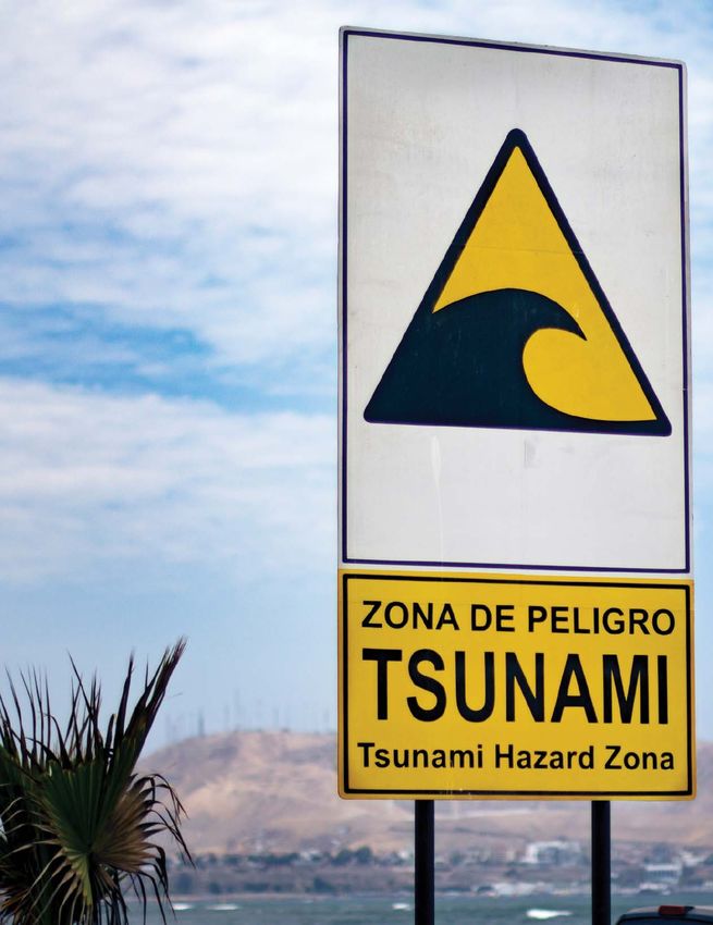
NEWS
To Make Better Hurricane Models, Consider Air Pollution
H
urricane Harvey shocked the world in
2017 when it stalled over Houston,
defying hurricane models and dump-
ing 1.25 meters of rain onto the city. Accord-
ing to new research by a team of atmospheric
scientists, a previously unaccounted for vari-
able helped to drive the deluge: industrial air
pollution.
To investigate the role of air pollution, the
researchers compared models with and with-
out aerosols to observed data on Hurricane
Harvey’s path, rainfall, and lightning extent.
They found that air pollution was the major
factor that drove catastrophic flooding in
Houston, concluding that National Weather
Service models failed to predict the rainfall
because they didn’t take industrial aerosols
into account. They reported their findings in
Geophysical Research Letters (bit.ly/Harvey-
aerosols).
“The study presents compelling evidence
illustrating the widespread effects of indus-
trial aerosols on the evolution of Hurricane
Harvey,” said Zhanqing Li, an atmospheric Hurricane Harvey churns over the Gulf of Mexico in 2017. Credit: NASA
scientist who specializes in aerosols and was
not involved in the study.
The Striking Impact of Aerosols large amount of precipitation,” said Yuan The “clean” simulation, in
In recent years, researchers have begun to Wang, an atmospheric scientist at the Cali-
scrutinize the relationship between air pol- fornia Institute of Technology in Pasadena contrast, predicted less
lution and storms. Wildfires’ combined and a coauthor of the study.
than half that rate of
smoke and heat can affect local weather, for
instance, and lightning is more frequent over Hurricane Harvey’s Perfect Storm rainfall.
polluted skies. During the time that Hurricane Harvey sat
Particulate matter, especially very fine over Houston, a continuous source of mois-
soot, can hover in the air for extended periods ture was coming in from the Gulf of Mexico.
of time before settling to the ground, provid- On top of that already hefty source of rain,
ing a focal point around which water mole- factories continued to spew out more aero- actual rainfall rate of 32 millimeters per hour
cules can condense. When water droplets sols, providing a continuous source of air par- and also predicted the particularly intense
form around the particles, a small amount of ticles to supercharge the storm. lightning observed during the hurricane. The
heat is released. In this way, more pollution “In this case, all the factors came together “clean” simulation, in contrast, predicted
leads to more condensed water and more to set the stage for aerosols to play a huge less than half that rate of rainfall.
heat, which in turn produces heavier rainfall role,” Wang said. The team’s findings show that greenhouse
and more intense lightning. To test the idea that Houston’s air pollution gas emissions can have profound impacts on
Conditions in Houston came together to played a role in Hurricane Harvey’s record- extreme weather events at even the local
maximize aerosols’ amplifying effects during smashing rainfall, the researchers looked at level, Wang said. Failing to take these impacts
Hurricane Harvey. Southern Texas has more both ground- and satellite-based rain and seriously can have serious consequences and
than 400 densely distributed oil refineries, lightning measurements to get a clear under- heavy costs.
and Houston in particular often exceeds standing of the actual amount of rainfall and “Traditionally, in the hurricane commu-
national average annual air pollution levels. lightning over Houston between 26 and nity, aerosol effects have always been
But although previous studies have tried to 28 August 2017. They then used the cloud- neglected in operational forecast models,” Li
understand how the urban heat island effect resolving Weather Research and Forecasting said. “This work shows that such an omission
and global warming affected Hurricane Har- model to simulate Hurricane Harvey with and may lead to significant errors in hurricane
vey, no one had yet focused their attention on without the presence of Houston’s industrial forecast and predictions.”
the role of the city’s air pollution. “I think we air pollution.
are among the first to argue that the aerosols The simulation incorporating air pollution
played a determinant role in producing the data accurately modeled Hurricane Harvey’s By Rachel Fritts (@rachel_fritts), Science Writer
8 Eos // MARCH 2021NEWS
Corn Syrup Reveals How Bubbles Affect Lava’s Flow
ers, which makes it ideal to work with. In this
experiment, researchers created three liquids
using corn syrup and differing infusions of
citric acid: pure corn syrup with no bubbles,
bubbly corn syrup, and bubbly corn syrup
containing suspended particles.
The researchers then poured the liquids
down a meter-long plastic plank propped up
at an acute angle to mimic how lava flows
from a volcano. A camera tracked movement
while a laser sensor monitored the bubbly
flows’ thickness.
Pure corn syrup containing no bubbles
moved the fastest, with bubbly corn syrup
flowing slightly less rapidly. Bubbly corn
syrup suffused with particulate matter
moved more slowly and split into channels
that flowed at different speeds—the liquid
in the middle section moved faster, whereas
the liquid on the flow’s flanks moved more
slowly.
Hawaii’s Kīlauea volcano erupting in 2018. Credit: U.S. Geological Survey The experiment also revealed a gravita-
tional separation occurring, with bubbles
floating to the top as the fluid moved—a pro-
cess that creates a fragile gaseous shell in lava
I
n the summer of 2018, an eruption on the Atsuko Namiki, a volcanologist from Hiro- called pahoehoe in real flows. As bubbles rose
flanks of the active volcano Kı-lauea shima University in Japan, was on Hawaii to the top, the flow’s more concentrated liq-
in Hawaii sent lava flowing through when the eruption occurred. She noticed that uid touched the base of the slope, where it
the Puna district toward Kapoho Bay. The the flow was “amazingly quick” at first, but accelerated the flow’s overall speed.
relentless threat from wide channels of mol- it became much slower as it continued away According to Pranabendu Moitra, a physical
ten rock forced about 2,000 residents to evac- from the rift zone on the volcano’s slopes. volcanologist at the University of Arizona who
uate. By the end of the eruption in early Sep- “I was really surprised at the difference,” was not involved in the study, the research
tember, 24 people were injured, 716 said Namiki. “I wanted to explain the abrupt represents an effort to understand lava flow
structures were destroyed, and the flows change of the flow patterns with bubbles and in all three of its phases: liquid, bubbly, and
left $800 million worth of damage in their without bubbles.” particulate.
wake. “This is one of the first of its kind,” Moitra
Although it’s not uncommon for lava flows said. “This has potential to be the basis for a
to have bubbles, samples from the 2018 lot of future research.”
Kı-lauea event revealed a high percentage Future lab experiments analyzing the
of gaseous bubbles by volume—more than
“This has potential to be detailed physics of lava flows could help pro-
50% in some cores taken after the flows solid- the basis for a lot of future vide more accurate predictions for commu-
ified, according to research presented at nities at risk of damage from volcanic erup-
AGU’s Fall Meeting 2020 (bit.ly/bubbly-lava).
research. tions, said Birnbaum. Observations of a flow’s
Some of the bubbles were large, roughly likely movement patterns and speeds,
a meter in diameter. The h igh- p rofile depending on its gas content, could aid public
event provided an opportunity for volcanol- safety authorities in preparing more reliable
ogists to observe up close how dramatic out- The researchers’ findings showed that evacuation notices.
g assi ng affected the way lava flows bubbles clearly affect lava’s viscosity, or its Not all results require expensive gear or
down slopes and spreads across flatter areas. relative thickness and fluidity. “Small trips to dangerous zones, said Namiki. She
However, r e-creating a stream of molten changes in texture can lead to big and lasting hopes the simplicity of their experiments,
rock in the lab to capture detailed physics changes in dynamics,” said Janine Birnbaum, which used common and inexpensive mate-
in action isn’t feasible. So a team of interna- a graduate student at the Lamont-Doherty rials, inspires others to continue similar
tional scientists created an analogue Earth Observatory at Columbia University research.
using corn syrup, baking soda, citric acid, who worked on the study.
and an inclined slope with the aim of shed- Corn syrup is a common experimental ana-
ding light on how a high volume of bub- logue for lava. According to Birnbaum, the By Allison Gasparini (@astrogasparini), Science
bles affects the way lava flows. syrup’s viscosity can be tweaked by research- Writer
SCIENCE NEWS BY AGU // Eos.org 9NEWS
Waterways Change as Nearby Cities Grow
L
arge rivers powerfully sculpt landscapes,
but their smaller brethren—streams—
are much more numerous and affect local
communities and ecosystems. Now scientists
have used multidecadal data sets to trace how
streamflow across the continental United
States has changed in response to urbaniza-
tion. They found a variety of trends, compli-
cating the long-standing notion that city
growth has a consistent impact on nearby
waterways.
Decades of Streamflow
Aditi Bhaskar, a hydrologist at Colorado State
University in Fort Collins, and her colleagues
started by mining a U.S. Geological Survey
(USGS) data set of streamflow measurements.
The data set, which included measurements
across the United States from more than 9,300
streamgages, stretches back decades. “That’s
our best n ational-scale measurement of
streamflow,” said Bhaskar.
Bhaskar and her collaborators combined
these streamflow data with records of housing
density and impervious surface cover (e.g.,
concrete, asphalt). They honed in on gages
that had an uninterrupted streamflow record
of at least 20 years and whose watersheds—
ranging in size from 5 to 162 square kilome-
ters—were undammed and also satisfied cer- Researchers are studying how streams, like this one in Iowa, are affected by nearby urbanization, a new longitu-
tain criteria related to size, impervious surface dinal study reveals. Credit: iStock.com/lynngrae
cover, and housing density.
“We wanted to look at watersheds while
they’re being urbanized,” said Bhaskar.
The researchers whittled down their sample experienced both increases and decreases in Cities, with their impervious surfaces, also
to 53 gages across the continental United flow. “It was pretty evenly split between look different than nonurbanized areas. These
States in areas such as Colorado Springs, Colo.; watersheds where low flows increased with surfaces prevent rainfall from filtering into the
Indianapolis, Ind.; and Austin, Texas. The spa- urbanization and other watersheds where low ground, so storm runoff, which is often routed
tial coverage of the final sample is probably flows decreased with urbanization,” said directly to streams, can lead to increasingly
biased, Bhaskar and her colleagues noted. Bhaskar. “We don’t see consistency.” high flows, said Bhaskar.
“Streamgages are largely put on perennial riv- That’s an important finding, said Sarah H. These results were published in Water
ers, rivers that flow all year-round,” said Ledford, a hydrologist at Georgia State Uni- Resources Research (bit.ly/streamflow-records).
Bhaskar. “Our analysis is, of course, biased in versity in Atlanta not involved in the Bhaskar and her colleagues are investigat-
the same way that the USGS streamgage net- research. It counters the assumption that ing a few individual watersheds in greater
work is biased.” streams everywhere exhibit a homogeneous detail. The goal, she said, is to get a more
response to urbanization. “Urban hydrology nuanced look than what’s possible with a
Zooming In on City Growth was oversimplified from the start,” said Led- national-scale study. In Maryland, the team is
Bhaskar and her colleagues then matched each ford. analyzing how the presence of green infra-
watershed with a similarly sized watershed structures—such as infiltration trenches and
that had experienced only minimal urbaniza- Draw and Release tree boxes—affects changes in streamflow.
tion. That allowed the team to subtract It makes sense that streamflow would vary as And in Colorado, they’re looking at streamflow
climate-induced changes in streamflow and a city grows, said Bhaskar, because urban areas changes that result from a practice common
isolate just the changes associated with city both draw and release water. “Upstream of the in urban areas: watering one’s lawn.
growth. city, there’s the withdrawal for the water sup-
The scientists found mixed results: Higher ply. A little bit downstream, but upstream of
streamflows tended to exhibit increasing flows the next city, is the wastewater effluent By Katherine Kornei (@KatherineKornei),
as areas urbanized, but lower streamflows release.” Science Writer
10 Eos // MARCH 2021NEWS
Dirty Trees Shape Earth’s Hydrologic and Carbon Cycles
W
hen each raindrop falls through a
forest canopy and reaches Earth, it
ferries creatures and contaminants
to soils and streams below. Researchers have
only recently begun to explore the fine details
of this journey; their work was featured in a
session titled “Precipitation Partitioning by
Vegetation” at AGU’s virtual Fall Meeting
2020 (bit.ly/precip-partitioning).
When a raindrop falls over land, it might
bounce off leaves or slide down tree trunks
before reaching the ground. Depending on
where it lands, that drop will eventually con-
tribute to a river, be absorbed into a forest
floor, or evaporate back into the atmo-
sphere. This distribution of precipitation by
trees and shrubs is often the first step in the
terrestrial hydrologic cycle, yet fundamental
data on its consequences remain relatively As rain flows down grimy tree branches, it becomes a rich, nutritious tea for soil communities below. Credit: John
sparse. Van Stan
“We tend to ignore canopies as an interface
for water to reach the Earth’s surface,” said
John Van Stan, an ecohydrologist at Georgia
Southern University. “But they connect to so uum. The Fall Meeting session included a are like miniature Amazons capable of trans-
many aspects of an ecosystem. They’re the number of posters related to particulate porting carbon and nutrients in volumes
first thing that controls where water goes.” transfer by precipitation and how human comparable to those of large streams and riv-
disturbances, such as forest thinning and ers. Yet “we know practically nothing about
More Questions Than Answers fire, change the capacity for canopies to store it,” Van Stan said. Indeed, he noted, hydrol-
When hydrologists consider what happens water. ogists interested in canopy water traditionally
when rain filters through trees and plants, Gutmann said he’s particularly excited filtered out the organic matter and tossed it
they confront a host of important ecological about one study, led by Dominick Ciruzzi at the in the trash.
and societal questions: How much rainfall University of Wisconsin-Madison, in which a By directing water and nutrient flow within
actually reaches an aquifer? How does c lear- team attached accelerometers to street trees the critical zone, plants influence numerous
cutting a forest affect local weather? How do to measure how much rainfall they intercept biogeochemical cycles. But the extent of their
urban trees aid storm water management? on their leaves. The study showed that rainfall influence remains a mystery.
A growing set of research projects has bound up in trees reduced the amount of water “There are always modeling papers saying
focused on this botanical portion of the that reached the ground below. When taken we still don’t have the best handle on the car-
hydrologic cycle. These studies accompany together, thousands of trees in an urban area bon cycle,” said Benjamin Runkle, who stud-
the rise in popularity of critical zone science, could be a sustainable tool to mitigate flooding ies carbon and water cycling in agricultural
which investigates the connectivity of the related to heavy rains. systems at the University of Arkansas and
“thin living skin” that coats Earth—from was not involved in the session. Understand-
treetops to bedrock. Measuring rain, fog, and Miniature Amazons ing the subtle yet powerful ways plants shape
snow within the convoluted texture of a for- According to Van Stan, one of the most large-scale systems like weather, erosion,
est, however, is no easy task. understudied details of precipitation parti- and carbon transport is critical to building
“Because it’s such a challenging measure- tioning is the vertical transfer of biological better predictive models.
ment to take, [canopy water flow] has really materials from canopies to the soil below. “To really get the numbers right,” Runkle
been overlooked,” said Ethan Gutmann, a “Trees are really dirty, just covered in lots of said, researchers need to pay more attention to
hydrologist at the National Center for Atmo- organic matter,” such as feces, fungal spores, the details, one drop—on one leaf—at a time.
spheric Research in Boulder, Colo. “But we’re bacteria, and metazoans critical to how eco-
finding more and more, especially in water- systems function, Van Stan said.
limited environments, that it may be a very The numerous, tiny rivulets that form on By Cypress Hansen (@PollenPlankton), Science
large component of the water cycle.” branches, trunks, and stems during storms Writer
Last year, Van Stan, Gutmann, and their
colleagues published a book that synthesizes
past and present advances and ongoing
knowledge gaps about the transport of water u Read our Critical Zone issue: eos.org/special-topics#critical-zone
along the atmosphere-plant-soil contin-
SCIENCE NEWS BY AGU // Eos.org 11NEWS
New Volcano, Old Caldera
I
n May 2018, a barrage of earthquakes struck
Mayotte, the seismically quiet easternmost
island of the Comoros archipelago, which
stretches between Africa and Madagascar.
After months of investigating the unexpected
and intense seismic activity, French scientists
discovered a new submarine volcano in the
Indian Ocean approximately 50 kilometers
east of the island. This new seafloor feature is
evidence of, by volume, the largest docu-
mented underwater volcanic eruption in his-
tory, and both volcanic and seismic activities
continue today.
In the years since the initial quakes, teams
of scientists have refined the picture of the
structures below the seafloor. Building on this
foundation, marine geologist Nathalie Feuillet
and seismotectonicist Eric Jacques, both at the
Institut de Physique du Globe de Paris, and
their colleagues proposed the presence of a
large underwater caldera—a volcanic depres-
sion formed when a magma chamber drains The island of Mayotte, Comoros, is the site of ongoing seismic activity associated with what may be the largest
and collapses—located between Mayotte and documented underwater volcanic eruption in history. Credit: Earth Science and Remote Sensing Unit, NASA
the new volcano. A ring of earthquakes in the Johnson Space Center
mantle lithosphere delineates this curious
structure at depths where neither earthquakes
nor calderas typically occur.
Feuillet, Jacques, and other researchers pre- the nascent volcano was actively erupting into The donut-shaped western cluster began
sented their findings at AGU’s Fall Meeting the sea during the scientific cruise. With each shaking in the summer of 2018. Earthquakes
2020 (bit.ly/Mayotte-structure). subsequent campaign, scientists discovered tell scientists where faults are active, so this
fresh lava flows. ringlike cluster implies faults arrayed in a
A Timeline of Peculiar Events circle pointing to a possible caldera directly
Mayotte formed approximately 11 million From Seafloor to Mantle above. At depths of 25–55 kilometers, these
years ago and is the oldest in the chain of East of Mayotte’s shores, Feuillet described earthquakes originated in the mantle below,
Comorian volcanic islands, said Feuillet. The “the crown,” a circular structure on the sea- said seismologist Wenyuan Fan, an assistant
island slumbered until 10 May 2018. Then, in floor approximately 10 kilometers in diameter professor of geophysics at Scripps Institu-
the first 2 months of the seismic episode, more and dotted with many cones. She and her col- tion of Oceanography, who is not affiliated
than 100 events greater than magnitude 4.5, leagues interpreted the structure as the outline with the new studies. Earthquakes usually
including a magnitude 5.9 event, rocked the of an old caldera. An oceanic ridge stretches rupture brittle crust, where strain energy can
island. Its population, accustomed to stable eastward, away from the crown, truncated by accumulate, he said. Strain cannot accumu-
ground, had only a single seismic station to the fledgling volcano 50 kilometers from May- late at typical mantle conditions, so most
monitor the sudden crisis. otte. mantle tends to flow, inhibiting earth-
In November 2018, seismic stations around To explore the structures in the lithosphere quakes.
the world heard a mysterious hum that scien- below the seafloor, the team focused on two “One way to [get mantle earthquakes]
tists traced to Mayotte. This 25-minute-long distinct clusters of earthquakes. The eastern would be to bring down cooler materials that
signal vibrated at low frequencies, hinting that cluster, located between the suspected caldera can host earthquakes,” Fan said, which hap-
magma movement and volcanic activity were and the volcano, concentrates earthquakes pens in subduction zones. But the Mayotte
the prime suspects to explain the seismic cri- deep below the seafloor, parallel to the ridge, events are not related to subduction, leaving
sis. Back at sea level, Feuillet said local fisher- said Jacques. This cluster includes the inaugu- these mantle earthquakes a mystery.
men reported dead fish and a “burned tire ral earthquakes from May and June 2018, How the western donut cluster connects to
smell” during this time. which Feuillet said may indicate that a dike the eastern ridge cluster poses another quan-
In May 2019, the first of seven marine propagated from west to east before the erup- dary because they are not linked by earth-
cruises confirmed that 5 cubic kilometers of tion, pushing magma from a deep western quakes, said seismologist Lise Retailleau, also
lava had piled onto the previously flat seafloor, reservoir eastward and upward toward the vol- of Institut de Physique du Globe de Paris but
constructing an 800-meter-tall volcanic edi- cano, similar to the model proposed in a paper not part of Feuillet’s and Jacques’s studies.
fice, said Feuillet in her talk. The presence of published earlier this year (bit.ly/Mayotte Whether the lack of seismic connection
hydrogen gas in the water column meant that -magma-drainage). between the clusters indicates aseismic
12 Eos // MARCH 2021NEWS
magma transfer or some deeper connection
hidden from scientists, she said, “we don’t
really know.”
Also perplexing are observations of the lith-
osphere between the proposed caldera and the
donut cluster. Retailleau pointed out that the
caldera shows no evidence of volcanic activity
at the human timescale, even though most of
the seismicity recorded since 2018 congregates
below it. Even stranger, the upper crustal lith-
osphere between the surface and the top of the
donut cluster lacks earthquakes that would
indicate breaking, brittle crust. Instead, l ong-
period and very long period seismic events
associated with this eruption—events that
often imply magma movement—occur just
above the donut, said Retailleau. Feuillet said
that these events might foreshadow another
untapped shallow magma chamber above the
brittle rocks defined by the donut cluster. If
this magma chamber is active and continues
its upward path, Retailleau said it could affect
Mayotte and its population of more than a
quarter million people.
In this map of the topography and bathymetry of Mayotte, the red triangle indicates the location of the new vol-
canic edifice. The orange circle indicates the primary donut cluster of earthquakes below the possible caldera
structure. The green ellipse encloses the secondary cluster parallel to the caldera ridge. Credit: Lise Retailleau; By Alka Tripathy-Lang (@DrAlkaTrip), Science
bathymetry from GEBCO, SHOM HOMONIM, and REVOSIMA MAYOBS1; topography from IGN Writer
Read it first on
Articles are published on Eos.org before they appear in the magazine. Visit Eos.org
daily for the latest news and perspectives.
Using Earthquake Forensics to Study Subduction
from Space
bit.ly/Eos-earthquake-forensics
Tree Rings Reveal How Ancient Forests Were Managed
bit.ly/Eos-tree-rings
Sinking Fish May Fast-Track Mercury Pollution
to the Deep Sea
bit.ly/Eos-mercury-pollution
Graduate Student Perspectives on Equitable
Remote Learning
bit.ly/Eos-remote-learning
Cape Cod: Shipwrecks, Dune Shacks, and Shifting Sands
bit.ly/Eos-Cape-Cod
Very Good Space Boys: Robotic Dogs May Dig
Into Martian Caves
bit.ly/Eos-space-boys
SCIENCE NEWS BY AGU // Eos.org 13NEWS
Long-Term Drought Harms Mental Health
in Rural Communities
P
ublic health experts increasingly rec-
ognize that adverse weather and cli-
mate conditions can have negative
impacts on people’s mental health as well as
their physical health. Many emergency man-
agement organizations, for example, have
established or expanded postdisaster services
to include mental health assistance and sup-
port. However, little is understood about how
mental health is affected by the duration of
such conditions, especially when they last for
months or years on end, as can happen with
droughts.
Past quantitative research has focused on
linking characteristics of drought, such as the
severity of dryness, with mental health out-
comes, explained Tuyen Luong, a doctoral For farmers and ranchers in rural New South Wales, Australia (above), drought is a regular part of life and can
student at the University of Newcastle’s Cen- cause long-term harm to mental health. Credit: iStock.com/Capstoc
tre for Resources Health and Safety (CRHS) in
New South Wales, Australia. “In our study, we
focus on linking duration of drought...with
the mental health of people to explore their poor mental health seemed to lessen after a able to drought because they rely on agricul-
mental response to drought over time.” few years of the drought, other symptoms ture. And within rural communities there are
Residents of remote and rural communities became persistent or chronic. certain groups that are more vulnerable,” like
in southeastern Australia likely remember Luong presented this research at AGU’s adolescents and the aging population.
the Millennium Drought, which lasted from Fall Meeting 2020 (bit.ly/drought-mental Moreover, the effects of drought on phys-
1997 to 2010 and devastated ecosystems, -health). ical health, financial stability, and other
economies, and lives across the region. From stressors like water availability are different
2007 to 2013, scientists conducted a study of Learning to Cope for people living in rural and remote commu-
people living in those communities to explore Climate change is worsening drought condi- nities compared with people in urban set-
potential drivers of poor mental health, tions around the world and shifting natural tings. The results of drought–mental health
including the prolonged drought. drought cycles out of sync with agricultural studies that focus only on urban settings
Luong and her colleagues recently analyzed growing periods.. likely won’t be applicable in rural and remote
data from that study and found that the Mil- “Australia is particularly vulnerable to contexts, Austin said.
lennium Drought did indeed have adverse drought because we have such variable rain- The Australian Rural Mental Health Study
mental health impacts on people living fall,” explained Emma Austin, manager of (ARMHS) repeatedly surveyed more than
through it in remote and rural communities. CRHS and a co‑investigator on this research 1,800 households in remote and rural com-
Moreover, although some acute symptoms of project. “Rural communities are very vulner- munities in New South Wales. Over a 6-year
Fields affected by the Millennium Drought, which lasted from 1997 to 2010 and severely affected farmers in southern and eastern Australia, are seen here near Benambra,
Vic., in 2006. Credit: Fir0002/Wikimedia Commons, CC BY-NC 3.0 (bit.ly/ccbync3-0)
14 Eos // MARCH 2021NEWS
period, participants self-reported psycholog- completely return to baseline within this time these kinds of negative effects. But it is often
ical symptoms of poor mental health like dis- period makes a lot of sense, conceptually, difficult to obtain, especially in rural areas.
tress, worry, depression, anxiety, and suicidal especially if the drought is ongoing,” said Even doctors focused on physical health, and
thoughts, as well as the role of determinants Susan Clayton, a professor of psychology and other community officials, can be trained and
in their mental health and well-being like environmental studies at the College of encouraged to ask people about their mental
employment stability, social connectedness, Wooster in Wooster, Ohio. Clayton was not health and refer them to treatment options
and environmental adversity. involved with this research. “People learn to as required.”
In their analysis of these data, Luong and cope, but the quality of life is still lower.” Luong said that future analyses of ARMHS
her team found that people’s psychological data will explore how gender, age, and income
distress rose during the first 30–40 months Informing Policies ThatSupport factor into drought-related mental health
(roughly 2.5–3.5 years) of drought before pla- Mental Health impacts. A more nuanced understanding of
teauing and then decreasing. “There’s been a shift in Australian policy” in these factors can help create policies that
“People have lower distress at the later the past decade regarding drought, Austin provide the right kind of support through the
stages of drought, but this does not necessar- said. “It was very reactive, [but] now there’s entire period of mental health vulnerability
ily mean that people will display a good men- focus on the need to plan for drought all the and allocate often limited financial support
tal health condition,” Luong said. “We found time, not just in the drought times but in the to particularly at-risk populations.
that when droughts go on, [they] will lead to good times as well.” L ong-term, quantitative “Our work will inform policy and strategy by
a reduction in general life satisfaction, and studies like ARMHS are needed to measure providing better understanding” of the rela-
despair about the future will be increased.” the true toll that adverse environmental con- tionship among drought, mental health, and
Rather than indicating an improvement in ditions take on rural communities, she added. adaptive capacity, Luong said, “and from there
overall mental health and w ell-being, Austin “Research like this is important to share we can develop strategies to improve well-
said, the alleviation of distress might be with governmental agencies in order to being and therefore improve adaptive capacity
related to a developed trait known as adaptive strengthen support for mental health treat- and climate resilience in communities.”
capacity, a person’s ability to cope with ment networks, as well as awareness of the
adversity. problem,” Clayton said. “Access to mental
“The finding that mental health decre- health treatment, especially in a way that is By Kimberly M. S. Cartier (@AstroKimCartier),
ments tend to dissipate over time but do not not stigmatized, can help people to cope with Staff Writer
Guide to PREPARE
YOUR RESEARCH
1
Publishing 2
SELECT THE
with AGU
RIGHT JOURNAL
SUBMIT
YOUR MANUSCRIPT 3
If you’re considering AGU
journals for your latest research,
we’ve assembled steps to help COMPLETE
4
you navigate the process. PEER REVIEW
agu.org/pubs
PUBLISH 5
AGU supports open science and provides options
to meet the needs of all authors.
PROMOTE
6 YOUR PAPER
SCIENCE NEWS BY AGU // Eos.org 15You can also read