Discover San Juan Island - This packet belongs to: San Juan County Land Bank
←
→
Page content transcription
If your browser does not render page correctly, please read the page content below
Discover
  San Juan Island

This packet belongs to:
Welcome to Discover
            San Juan Island
The San Juan County Land Bank turns 30 this year!

Decades ago, members of the island community saw the area’s
population rapidly growing and it made them want to protect special
places in the archipelago. What would life be like if some of their
favorite places disappeared? If their children and grandchildren
didn’t have shorelines and forests to walk? People researched ideas
for protecting open space. They shared their ideas in community
meetings, and in November of 1990, your Land Bank was voted into
existence.

In honor of our 30th anniversary, your Land Bank, along with the
San Juan Island Library, invite you to celebrate our islands’ landscape
and its story of community foresight and imagination – protecting the
places we love.

Get outdoors this summer and enjoy some family fun discovering your
preserves and the stories they hold. Happy adventuring!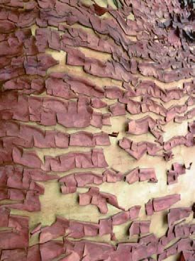
Be Prepared!

Remember to wear sunscreen, a hat, sunglasses, hiking boots, and
bring plenty of water and snacks. You may want to bring bug
repellent, too.

Keep your adventure packet in your car or your bag all the time, so
you’re always ready for whatever adventure might come your way.

Be good stewards! Make sure you’re being kind to the land, animals,
plants, and fellow humans you encounter on your adventures. Leave
the preserve as you found it, unless you’re picking up trash.

Bring a camera! Share your adventures with us by e-mailing
tanjaw@sjclandbank.org or youthservices@sjlib.org.

Tag us on Facebook (@sanjuancountylandbank) or Instagram
(@sjclandbank) #discoversji
Table of Contents
Westside Preserve Activities: pages 5-8
Link to online map:
http://sjclandbank.org/wp-content/uploads/2018/12/Westside_map_REVISED_10_2018.pdf

Frazer Homestead Preserve Activities: pages 9-11
Link to online map:
http://sjclandbank.org/wp-content/uploads/2016/04/Frazer_map_REVISED_4_2016.pdf

Mount Grant Preserve Activities: pages 12-14
Link to online map:
http://sjclandbank.org/wp-content/uploads/2019/09/driving-directions-SEP-2019.pdf

Limekiln Preserve Activities: pages 15-17
Link to online map:
http://sjclandbank.org/limekiln-preserve-and-westside-lake-san-juan-island/

                               Helpful Resources:
San Juan County Land Bank:
http://sjclandbank.org/

San Juan Island Library:
https://www.sjlib.org/

San Juan Preservation Trust - Island Marble Butterfly:
https://sjpt.org/what-we-do/care-for-land/stewardship/stewardship-projects/

San Juan Island National Historical Park - Pig War:
https://www.nps.gov/sajh/learn/historyculture/the-pig-war.htm
Westside Preserve
The Westside Preserve represents permanent protection for one of San
Juan Island’s most treasured areas. This, along with the Deadman Bay
and Limekiln Preserves, and Lime Kiln Point State Park and San Juan
County Park, protect habitat and create opportunities for recreation
along the western shoreline of the island. This is a place where dramatic
cliffs bridge the gap between land and sea, and give way to a once
expansive coastal prairie. While there are fewer native wildflowers here
today than may have once bloomed on this bluff, you may see camas,
satin flower, harvest brodiaea, shooting-star, field chickweed bicolor
lupine, and more!

                                     Draw the wildflowers you see on the trail.
Activity #1:
Take a walk on the fern lined trail that goes to the place where you can
look over Haro Strait from high above. Keep your eyes peeled along the
way – the goldenback ferns that the trail derives its name from are what
you seek. Take a selfie with one, or let the fern be the star, whichever you
prefer. What other plants did you see along the trail? Draw them below.
Activity #1:
Continue all the way up to the end of the trail. Get very quiet, maybe even
close your eyes. Can you hear it? “Pffhhh… pffhhh” Now open your eyes.
Can you see the black dorsal fin of an Orca surfacing off shore? If you are
lucky enough to see an Orca, the experience should be treasured. The
Southern Resident Killer Whales that forage, play and raise their young in
the Salish Sea are critically endangered due to threats to their food
source, Chinook Salmon, as well as environmental pressures posed by
vessel traffic and climate change. Imagine what the Orca would say to us
if we spoke the same language? On the next page, write or draw a short
story about an Orca adventure in the Salish Sea. Make it as long or as
short as you’d like, have fun with it!
Activity #1:
Frazer Homestead Preserve

The Frazer Homestead offers a peek into the diverse values that the
Land Bank has committed to protect. The agricultural fields are farmed
by a local family and the trail that runs between the fields and Cattle
Point Road offers an opportunity for low intensity recreation and helps
connect Friday Harbor and American Camp. The Frazer Homestead was
also the site of the start of the infamous Pig War; it was on this ground
that Lyman Cutlar shot the Hudson’s Bay Company pig, an event that
ended in the inclusion of San Juan Island in United States territory. In
addition to food production for humans and livestock, the Preserve is
also the site of a restoration plot for the endangered Island Marble
Butterfly. Our friends at the San Juan Preservation Trust sow the
butterfly’s host plant, a weed called field mustard, in hopes that a
butterfly will find the plant and lay its eggs there. In 2019 this dream
became reality - the first recorded island marble butterfly to lay eggs
somewhere other than American Camp!
To hold all of these diverse values in one Preserve is a feat, and it reflects
the diversity at play within the community of the island. As individuals,
we often focus on one or two of these elements to champion, but it is
important to remember that the places that they intersect are some of
the most special and that all perspectives have something to offer.

           Take your time walking this path and marvel at what
           community members have built to keep your feet dry.
           Strike a pose on the boardwalk!
Activity #2
Mount Baker
As you walk the one mile trail alongside the road, be sure to stop and take
in the view across the agriculture fields. There is a big mountain in the
distance. Can you name it? Use the boxes below to draw what else you
see along the trail.Activity #2 Imagine you are an island marble butterfly. What would it be like to be one of the butterflies searching for mustard plants to lay eggs on? What kind of challenges might they come across? What does it feel like to fly? Write, draw, or have a family member help you with your story. Image courtesy of San Juan Island National Historical Park and Karen Reagan/USFWS.
Mount Grant Preserve
Mount Grant Preserve has a lot to offer to many members of our
community, both human and non-human. The forests here are a
fascinating mosaic of old growth Douglas fir, riparian areas and areas
that were once much more open – more closely resembling a woodland.
The forests here tell a story of the way that humans have interacted with
the landscape over the past 11,000 years, since the glaciers retreated.
First Nations people often kept areas like the rocky slopes of Mount
Grant free of thick stands of trees through intentional burning. This
practice kept habitat open for the cultivation of prairie loving food plants
like camas and yampah. The burning may also have been used as tool to
make deer hunting easier. Much more recently, settlers that came to the
island in the late 19th century grazed their sheep and goats on the
mountain. Until the shift from a homesteading culture to a more modern
lifestyle, these hills were frequently exposed to disturbance that allowed
for the open grown Douglas firs that still stand today to thrive.
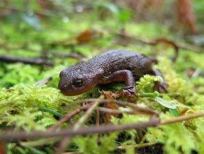
Newt
Find the trail named after this critter.
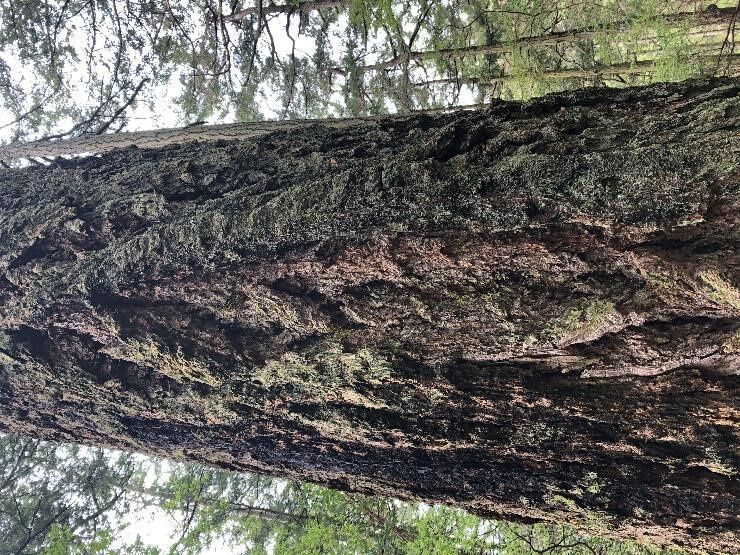
Draw a picture of what you find at the end of the trail.Activity #3 Head up the Greywacke trail (recently built by volunteers!) and look for the “triplets,” the group of three towering Douglas fir trees that have held each other up through fire, snow and rain. See the evidence of their tenacity in the fire scars that mark their trunks. Take a photo of (or with!) the three giants. What do you think the triplets have seen in their time here? Dive deep into your imagination and write or draw a story on the next page about what these trees may have experienced in the past, or will see in the future. (Hint: this is what the bark of a Douglas fir looks like)
Activity #3
Limekiln Preserve
Limekiln Preserve was home to a limestone processing operation from
1860 to 1935. The limestone mined here was processed in the kiln that
resides in the State Park. It was then barged off island to facilitate the
development of industry and cities along the west coast. Now, the land is
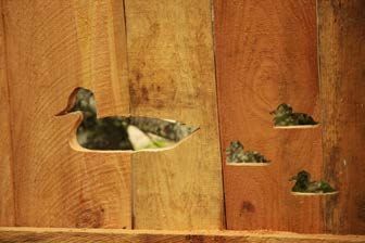
protected forever, and the ducks are happy about that! Home to
freshwater wetlands, dry forest, herbaceous balds and a network of
hiking trails, this preserve provides respite for humans and critters alike.
Walk the loop at Westside Lake to find this family of ducks.
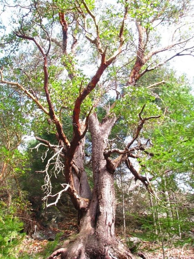
Draw a picture of what other birds you saw.Activity #4 Access the preserve from one of the points along Westside Road. Go on a nature quest and find your way to the Deadman Bay Trail. Pay special attention to the many red-barked Pacific madrone trees that grow here. Take a picture of (or with!) the one that you think is the coolest or most interesting. Imagine you are an animal living in that tree. What type of animal are you? Do you have feathers or paws? On the next page, write or draw what you look like. (Hint: this is what a madrone tree looks like, with a close up of its bark.)
Activity #4
You can also read