DRAFT SEPTEMBER 2016 - Huron-Clinton Metroparks
←
→
Page content transcription
If your browser does not render page correctly, please read the page content below
DRAFT SEPTEMBER 2016
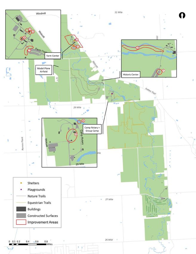
Table of Contents

 INTRODUCTION                        3
 ABOUT THE METROPARKS                3
 ADMINISTRATION & OPERATIONS         4
 PLANNING PROCESS                    5

 WOLCOTT MILL TODAY                  6
 CHARACTER                           6
 LOCATION                            8
 BIODIVERSITY AREAS                  9
 CULTURAL HISTORY                    11
 INFRASTRUCTURE                      13
 FACILITIES & CENTERS                15
 LAND                                17
 WAYFINDING                          19
 TRAILS                              20
 ACCESSIBILITY                       22

 REVENUE                             24
 REVENUE SOURCES                     24
 VISITORS                            25
 PROGRAMS & EVENTS                   26

 COMMUNITY INFLUENCES                27
 POPULATION                          27
 PROJECTS & INITIATIVES              29

 PUBLIC INPUT                        31
 OUTREACH PROCESS                    31
 RESULTS                             32

 ACTION PLAN                         35
 NEEDS & OPPORTUNITIES               35
 PROJECT LIST                        36
 PLANS, STUDIES, & INITIATIVES       40
 KEY PROJECTS                        43

                                 2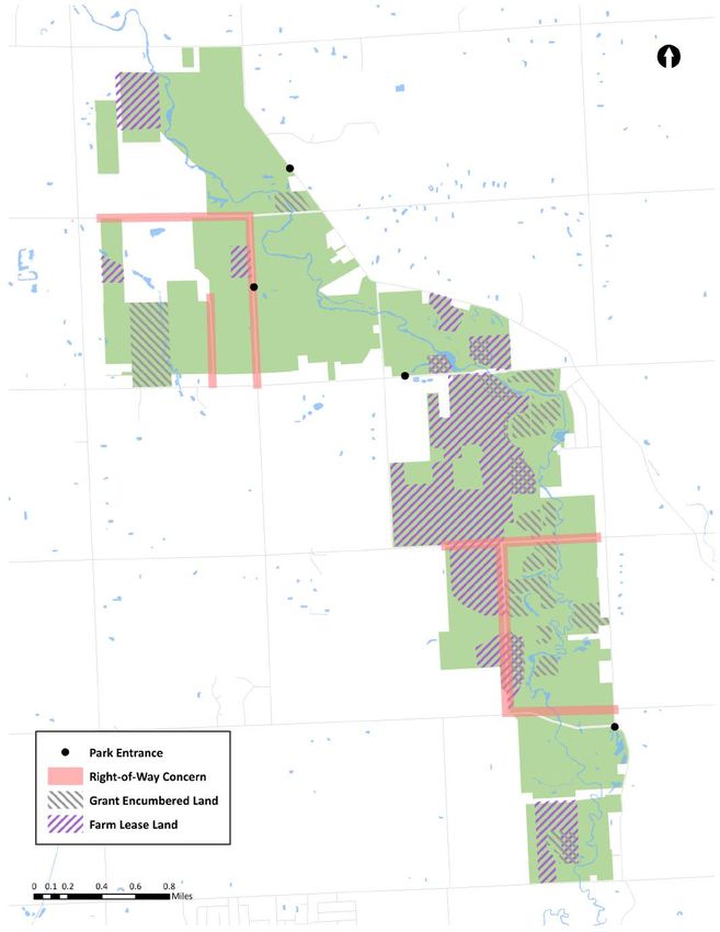
INTRODUCTION
 About the Metroparks                                                 i

 The Huron-Clinton Metropolitan Authority was sanctioned by the Michigan State Legislature in Act No. 147 of the Public Acts of
 1939. Named after the two longest rivers within its boundaries, the Huron-Clinton Metropolitan Authority is a regional park
 agency consisting of 13 Metroparks encompassing approximately 25,000 acres of land within a five county area in southeast
 Michigan.

 Much credit can be given to Henry S. Curtis and Harlow O. Whittemore for making the Metroparks a reality. The 1937 vision for
 a park system proposed a series of parks connected by a long parkway extending from Lake St. Clair along the Clinton and
 Huron rivers to Lake Erie below the mouth of the Detroit River.

 Funding of the parks began in 1942 with a property tax levy, limited to one-quarter of one mill. The rate today has been
 adjusted to .2146 mills.

PARK DEVELOPMENT TIMELINE

                                                                3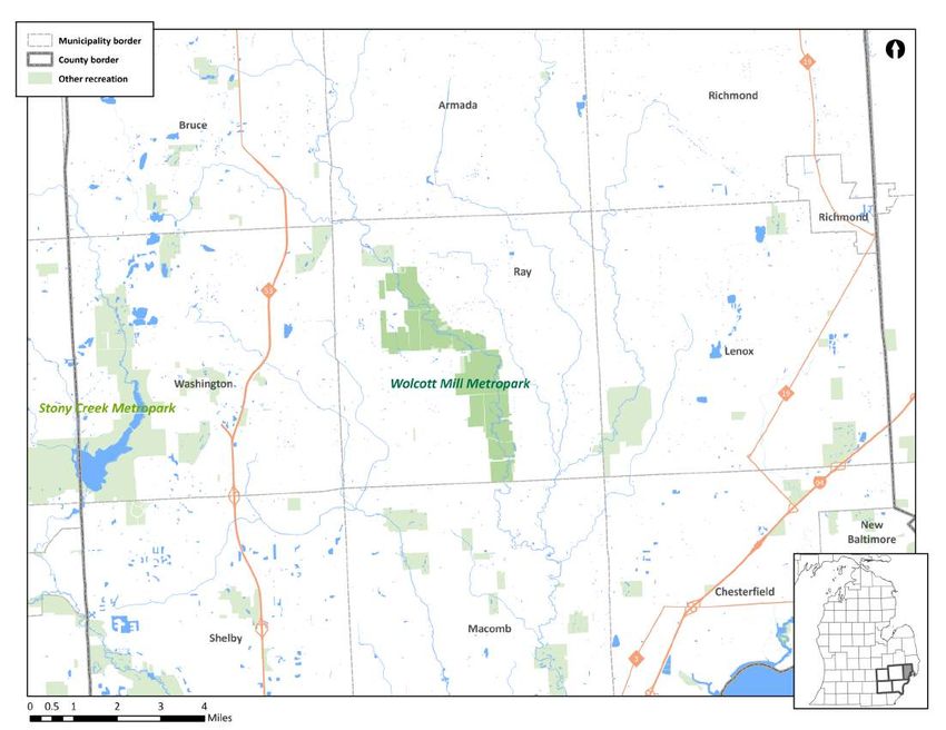
Introduction

Administration & Operations
 Board of Commissioners
 A seven-member Board of Commissioners governs the Huron-Clinton Metropolitan Authority. The Board of
 Commissioners meets the second Thursday of each month, where they make policy decisions for the Authority,
 including approving expenditures, acquiring land, planning of new parks and facilities, approving fees and
 charges, awarding contracts through competitive bidding, and other matters necessary to provide regional
 recreation. The Board appoints staff officers for the Metroparks.

 Two commissioners, appointed by the Governor of Michigan for a term of four years, serve as representatives at
 large. Five commissioners, one each to represent the counties of Wayne, Macomb, Oakland, Livingston and
 Washtenaw, are appointed for a term of six years by the board of commissioners of the above-named counties.

 Director is the Chief Executive Officer of the Metroparks, provides leadership and executive oversight of all
 administrative and operational activities.

 Administrative Departments provide administrative support to operations, and guide the organization
 towards its mission.

 Operational Departments facilitate the day-to-day operations of the parks, making sure patrons have
 enjoyable and educational visits. They include Maintenance and Interpretive Services.

 Metroparks Police ensure that everyone can enjoy the parks in a safe and secure environment.

                                                             4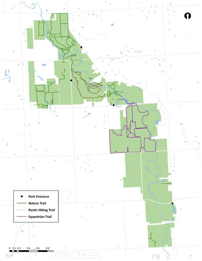
Introduction
                                                      2016

                                                                                                              Planning Process
                     Stony Creek

                                                                          Several factors contribute to the recommendations that will be proposed for
                     Wolcott Mill

                                                                          Wolcott Mill inside the master plan. One of the most important is the public
                                                                          input collected through meetings, questionnaires, and online comments. This
                                                                          reveals the public’s hopes and expectations for the park and significantly
                    Lower Huron

                                              Formal Public Survey        influences plan recommendations. A master plan steering committee was
                                                                          formed to include park employees with exceptional knowledge of Wolcott Mill
                                                                          and the surrounding community, who along with the experienced Metroparks
                                                                          department heads provide their professional opinions.
                     Kensington

                                                                          The Metroparks Planning Department has scheduled an aggressive timeline for
                                                      2017                completing all 13 park master plans in three years. Each park will be given a
                     Hudson Mills

                                                                          planning window of four months, with overlap between parks. The order of the
                                                                          parks in the planning process was determined by staff based on current and
                                                                          planned park projects, planning need, geography, and park popularity.
Lake St. Clair
 Park Master Plans (13)

                                                                          The Planning Department collects demographic and spatial data to inform
                                                                          master plan recommendations. Demographic data looks at the density, age,
                                                                          race, income, language, and other factors of the regional population. Spatial
                Indian Springs

                                                                          data, usually analyzed through Geographic Information System software, looks
                                     5 Year Recreation &
                                                                          at the physical location of the parks in relation to other recreation
                                     Strategic Development Plan
                                                                          opportunities, transportation facilities, population centers, important natural
                                                                          resources, and more. Finally, the Planning Department conducts a review of
               Lake Erie

                                                                          park conditions to identify areas needing improvement and areas experiencing
                                                                          success.
                                                      2018
                                                                          The master plans are intended to be living documents, modified as needed to
               Willow

                                                                          reflect changing conditions in the parks. However, they focus on park
                                                                          developments over the following ten years, and will be updated every decade
    Meadows
    Huron

                                                                          through a formal planning process similar to the current one.
    + Delhi
    Dexter-Huron

                                                                          Public       Demographic
                                                                          Input           Data
                  Oakwoods

                                                               Steering            MASTER           Spatial
                                                              Committee             PLAN           Analysis

                                                      2019           Department             Conditions
                                                                       Heads                 Review
                                    10-Year
                                    Updates                                                                           The Steering Committee for the Wolcott Mill
                                                                                                                                     Master Plan met on 7/11/16

                                                                                            5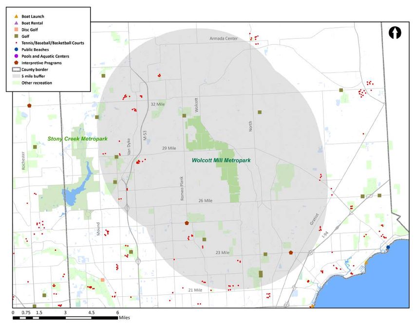
WOLCOTT MILL TODAY
Character                                                                                          NEEDS
The following responses to our survey questions highlight the                             Better highlight and advertise
many facets of Wolcott Mill that form a unique experience. The                              special character of park
park offers a rural, rustic feel that visitors value, as well as fun
                                                                                         Expansion of available events and
activities for children and adults.
                                                                                                 activities at park

                                                                                          OPPORTUNITIES

             Thank you for maintaining the
             Historic Center/ Mill. For many                                 Wolcott area off Kunstman is a real gem for the
               people like myself, visiting                                     nature lover, hiker, wildlife enthusiast.
              historic sites is an important
            part of my recreational activities.

                  The farm center is a hidden treasure
                          in Macomb County.
                                                                                        I take my wife to Wolcott now and we
                                                                                        really enjoy the scenic beauty and it's
                                                                                         quiet, peaceful. It's a nice change of
                                                                                                pace from Stony Creek.

        I've brought my children here                                  I love Wolcott Mill Metropark, especially the farm!
            over the years and now                                        This is one of the best farm settings in all of SE
        grandchildren. I love this park!                                                      Michigan

                                                                       6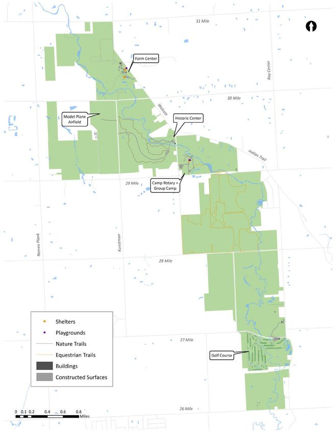
Wolcott Mill Today       General Map

                     7
Wolcott Mill Today

Location
Wolcott Mill Metropark is located in Macomb County in
southeast Michigan. It is approximately halfway between M-59
and the Lapeer County border. This is the largest Metropark in
the system to be located solely within one municipality, in this
case Ray Township.

At its northernmost extent Wolcott Mill reaches 31 Mile, its
eastern boundary is Ray Center Road, to the west it nearly
reaches Romeo Plank, and to the south it extends to 26 Mile.
The park is situated on the North Branch of the Clinton River.

                                                                 8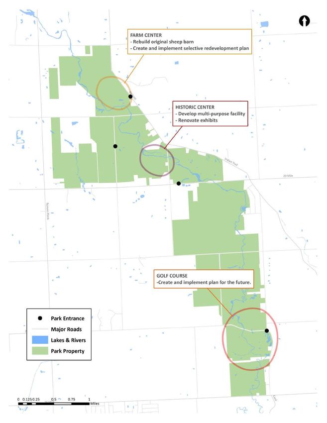
Wolcott Mill Today

                         NEEDS                                                    Biodiversity Areas
               Define and protect areas with
              important biodiversity features
                                                                        Identifying biodiversity areas can help inform the development
                Create a resilient network of
                                                                        of current and future park amenities, allowing the Metroparks
                biodiverse areas in the park
                                                                        to fulfill its mandate and mission statement of protecting the
                                                                        natural resources of the communities it serves. Development
                 OPPORTUNITIES                                          within biodiversity areas is carefully reviewed to minimize
                                                                        unnecessary disruption.
       Biodiversity refers to the variety of life present in a
       given area, often measured by number and distribution            The following criteria for determining biodiversity areas were
       of species. It is important to preserve because it               adapted from a matrix that the Natural Resources Department
       provides humans with ecological services such as clean           uses to determine work priorities throughout the park system.
       water and oxygen, leads to greater resistance and                The following page shows a map of proposed biodiversity areas
       resilience during natural and human-caused                       in Wolcott Mill.
       disturbances, and reduces the risk of disease.

       Metric                 What                       Why                     Metric               What                     Why
Elemental             the presence of a         statutory,                  Percent Invasive   percentage of total    areas with few
Occurrence            species under legal       occurrences                 Species Cover      acreage with           invasive species
                      protection, or of a       protected by law                               invasive plant         require less work,
                      complete system           from intentional take                          coverage               have greater return
                      recognized as in                                                                                on investment
                      condition similar to
                      pre-settlement
FQA                   presence of plant         determines the              Community          rank assigned by the   assesses the
(Floristic Quality    species likely to occur   ecological value of a       Ranking            state due to natural   vulnerability o f each
Assessment)           in conditions similar     system based on its                            community rarity or    natural community
                      to pre-settlement         floral assemblage                              rate of decline        within the state

FQI Connectivity      the presence of a         connected habitats          Wetlands           the presence of        wetlands tend to
                      quality habitat           provide diverse                                wetlands               have greatest
                      (greater than 35 FQI)     resources and                                                         diversity, and are also
                      within 100 feet of        facilitate migration,                                                 critical to promote
                      another                   increase species                                                      healthy water
                                                fitness                                                               resources

Size                  acreage of the habitat large habitats provide Habitat                    the presence of a      connected wetlands
                      in question            more diverse           Connectivity               complementary          promote genetic
                                             resources and                                     habitat within 100     diversity conservation
                                             facilitate migration,                             feet of another        and water quality
                                             increase species
                                             fitness, resilience

                                                                        9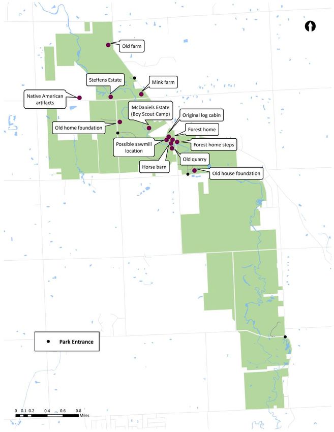
Wolcott Mill Today        Biodiversity Map

                     10
Wolcott Mill Today
Cultural History NEEDS
Preserve features of historic
structures
HISTORIC CENTER
Draw new visitors with
The grist mill that gives this park its name dates back to
programming/education based on
the mid 1800s, when milling was an essential industry
history of park
in Michigan and Macomb County. The mill was built in
1845 by one of the important early families in the OPPORTUNITIES
county, the Freemans, and passed though several other
hands before being sold to Frederick Beech Wolcott in
1878. Wolcott modernized the mill and created a
successful business selling Old Times flour sacks. During
his ownership , Wolcott restored the appearance of the
mill, purchased a turbine wheel, and added an
improved roller system in 1890.
The surrounding buildings were built in the following
years, consisting of barns, storehouses, an equipment
repair shop, a large structure that served as a waiting
room, and a two story white frame family house, where
the Wolcott family lived until 1969.
After his death in 1921, the Wolcott children continued
operation of the mill, converting to electrical power and
selling flour to bakeries in Detroit.
The mill closed in 1968, was briefly planned as an
agricultural campus for Macomb Community College,
suffered vandalism and the removal of the house
structure, and was transferred to HCMA ownership in
1979 . FARM CENTER
The Horse Barn and Dairy Barn located at the Farm
Center were built in 1918 and serve as reminders of
the long, important history of agriculture in southeast
Michigan.
CAMP ROTARY
Camp Rotary was purchased from the Macomb County
Rotary Camp and Training Association and became a
part of Wolcott Mill in 1996. The legacy of the camp is
preserved in the Little Mac Bridge, built by the Gratiot
Council, Wolverine Chapter of the Telephone Pioneers
of America in 1962.
11Wolcott Mill Today Cultural History Map
12Wolcott Mill Today
Infrastructure NEEDS
Wolcott Mill is less developed than most other Increased connectivity between
Metroparks and contains a smaller amount of structures
infrastructure. The four nodes of activity—Farm Center,
Historic Center, Camp Rotary and Golf Course—contain Unification of structures will create
most of the buildings, utilities, roads, and trails in the accessible network throughout
park. various park areas
Unlike other Metroparks, the nodes of activity in Wolcott
Mill are not connected by roads. Each one is accessible OPPORTUNITIES
through a separate park entrance, and to drive from one
to another requires exiting the park. Although these
nodes will likely remain separated for vehicular traffic,
WOLCOTT MILL INFRASTRUCTURE
plans are underway to improve non-motorized
Buildings 30
connections among the various centers of activity.
Avg bldg age 89
The Camp Rotary area of the park features extensive Active wells over 20 yrs 1
equestrian trails, which draw users from across the Paths & trail miles 27.48
region. At the Historic Center, hiking trails trace the paths Road miles 1.82
of previous inhabitants of the land and offer rural scenery. Playgrounds 1
The historic nature of the park means that the average Percent of park mowed 2.1
building age is much higher than that of other parks in the Picnic shelters 3
system. Several date back to the mid 1800s. Although this Sand volleyball courts 1
preservation of these structures is important, they pose Baseball fields 2
special maintenance challenges. Fishing platforms 1
Parking lot acreage 4.13
13Wolcott Mill Today Park Infrastructure Map
14Wolcott Mill Today
Facilities & Centers
Wolcott Mill features a number of facilities that define its character
and enhance the recreational experience of visitors. Some of these
either require an admission fee, are available for rentals, or sell
concessions, supplementing park revenue. As with all park
infrastructure, it is a priority to keep the facilities well-maintained and
replace them when no longer functional.
HISTORIC MILL
GOLF COURSE This grist mill was built in the 1840s and is listed on the
National Register of Historic Places. It allows visitors to learn
The golf course at Wolcott Mill features beautiful
about the importance of such mills to the economic history
landscapes, including the North Branch of the
of the region. The age of the building means that
Clinton River. However, the clubhouse and other
maintenance can be extensive, as seen in the recent
amenities are aging, and the course generates the
remodeling.
least revenue of all Metroparks courses. Therefore,
closing and repurposing the Wolcott Mill golf
course is a possibility in the future.
FARM CENTER
This fully-functioning dairy farm allows visitors, including
CAMP ROTARY many children, to learn about agricultural practices and the
A multi-activity center for kids, provides camping spaces process of bringing food from the farm to the table. With
for organizations, visitor ceremonies and receptions. Host baby goats, sheep, and pigs born every spring, it also allows
camping, rental facilities for groups and meetings, fishing, visitors to experience up-close the farm animals they may
hiking, and an observatory. only see from a distance.
Shorian Lodge
This lodge is a popular venue available for scout and
youth groups for overnight camping stays. The building,
located at Campy Rotary, accommodates 34 people.
Observatory
This building is operated and maintained by the Warren
Astronomical Society, which holds events there.
Activity Building
Built in 1964, this building is rented out for picnics,
parties, and other gatherings and can hold up to 120
people. It features a beautiful view of the Clinton River.
15Wolcott Mill Today Facilities & Centers
The Metroparks are moving towards a more data-driven approach to
locating facilities. In order to best serve the residents of southeast
Michigan and use resources wisely, the Planning Department has
NEEDS
identified the location of similar facilities and programs. The goal for Increased space for interpretation
future development is to avoid duplication and instead offer unique and interactive learning, as well as
facilities that fill recreation voids in the geographic area where the park events
is located.
Work towards a park with unique,
The map below shows the location of aquatic facilities, golf and disc
well-maintained facilities that meet
golf, neighborhood sports facilities, and interpretive programs that
all visitors’ needs
compete with those offered at Wolcott Mill. Several golf courses exist
within ten miles of the park boundary, but very little other recreational
offerings can be found nearby. Although there are a few clusters of OPPORTUNITIES
court and field sports nearby, even these are scarce in the immediate
surroundings of the park.
NEARBY FACILIITES
Amenities within 5-mile radius
of Wolcott Mill
Boat Launches 0
Boat Rentals 0
Pools 0
Public Beaches 0
Disc Golf Courses 0
Golf Courses 9
Tennis / Baseball / 67
Basketball Courts
16Wolcott Mill Today
NEEDS Land
Work with county to address park
boundary issues
Create good working relationship
ENCROACHMENTS
with neighbors and partner
The Planning Department has worked with Wolcott Mill
organizations
park staff to identify external encroachments on park
boundaries. These include individuals mistakenly building
OPPORTUNITIES on park property, dumping waste, or breaking through
fence lines. Together with a new combined map of county
LEASES
parcels in relation to historic HCMA-created parcels, this
In a unique arrangement, parts of Wolcott Mill land have
will help staff resolve existing property issues.
been leased to local farmers for agricultural production,
for periods of three years. This serves to generate Some areas of the park have been subject to mudbogging,
revenue, preserve the land from development, and which involves driving a vehicle through a pit of mud or
support the farming heritage of the area. wet area. The park does not have facilities to support this
activity, and illegal mudbogging has caused deterioration
GRANTS
of natural resources and damage to restored wetlands.
A small segment of Wolcott Mill is encumbered in
perpetuity—meaning it may not ever be converted into INFORMAL ACCESS
a non-recreational use. This particular park did not These are areas where visitors have access into the park
receive grant funding, but the parcel was used to from areas that are not designated as entrances. These
mitigate the conversion of land in Stony Creek into non- areas impact visitor counts, park pass revenue, and the
recreational use when a cell tower was constructed. safety of park guest. These areas should be rerouted and
closed.
GAPS
Pieces of land comprising Wolcott Mill remain largely
disconnected from one another. Trail connections are
being planned and considered to unify the park.
RIGHTS-OF-WAY
Rights-of-way are a concern in areas where a road not
owned by the Metroparks divides or has the potential to
divide park land. Their are six sets of roads in Ray
Township that raise this concern, and they are
highlighted on the next page.
17Wolcott Mill Today Land Map
18Wolcott Mill Today
Wayfinding NEEDS
Replace outdated, confusing,
inconsistent signs
Vehicular Wayfinding
Create consistent, convenient
Standardization wayfinding system to give visitors
Currently Metroparks include signage installed at various confidence
times with various standards and designs. This does not
reinforce the parks working together as a system and can be OPPORTUNITIES
confusing for visitors. As older signs reach the end of their
lives, they will be replaced with new, standardized signs.
Trail Wayfinding
Simplicity
In many parks, including Wolcott Mill , an abundance of Standardization
signage is not necessarily useful for directing visitors. Trail types present in the Metroparks include shared use,
Minimizing duplication of signs and expressing sign mountain bike, ski, nature and rustic, and equestrian.
information simply will make navigation easier for users of Despite their different functions, these trails together
the park. create a complete recreation system, so signage will be
based on a uniform template.
Symbols
Symbols are useful for expressing information in a small Flexibility
amount of space, and also make park facilities more In order to serve the differing needs of users on these
accessible for visitors who have trouble reading or speaking various trail types, the signage template will allow for
English. A standard set of symbols has been developed to be removable panels and be customized to fit the needs of
used in wayfinding signage. that user group.
Legibility
For many people, the easiest way to orient oneself in a
new environment is through use of a map. For greater
ease of use, all new trail wayfinding signs will include a
map marked with a “you are here” symbols and the
location of important park features and amenities.
Due to the small number of interior park
roads within Wolcott Mill Metropark, the
majority of directional signs will be either
pathfinder signs installed on country and
local roads or trail wayfinding signs
oriented towards pedestrians.
19Wolcott Mill Today
Trails NEEDS
Update trail system to include
As part of the master planning process, staff have categorized and informal paths
defined the various types of trails in the park, inventoried the
miles, and specified the uses and design of each. This formal Draw new visitors to the park with a
listing allows for assessment of availability of trails for various high-quality trail network
users in comparison to user group demand. It will also lead to
more standardized maintenance and rule enforcement processes. OPPORTUNITIES
Trail Type Miles in park Allowed Uses Prohibited Uses Surface
Rustic Trail 15.13 Pedestrian use only; Motorized vehicles, Width and material vary,
running, jogging and pets. bikes and horses. often dirt trails.
Snowshoes and cross-
country skiing are
permitted on designated
trails only.
Nature Trail 3.03 Pedestrian use only; hiking Motorized vehicles, Trail surfaces vary and
and walking. Snowshoeing running, jogging, pets, include asphalt,
is permitted on all Nature bikes and horses. aggregate, mulch and
Trails except those compacted earth.
designated for cross- Portions of these trails
country skiing. Cross- are accessible, but most
country skiing is permitted are not ADA-compliant.
on designated trails only.
Equestrian Trail 8.62 Horses and Pedestrians; Motorized vehicles, Typically dirt single track,
cross-country skiing is pedestrians, bikes, trail widths vary.
permitted in the winter on snowshoes and pets.
designated trails only.
Wolcott Mill has a less developed trail system than most other Metroparks, and many park patrons use informal trails or
service paths for recreation. In particular, the rectangular trails in the western section of the park were previously used as
tractor paths for farms but are currently maintained by the park for hiking. These have been classified as rustic trails due to
their limited use restrictions and limited maintenance. In the future, the Metroparks will work towards defining and
enhancing trails that fit well with the overall plan of the park and user needs. Displaying frequently used trails on official
park maps will be a priority.
20Wolcott Mill Today Park Trails Map
21Wolcott Mill Today
Accessibility
NEEDS
To remain compliant with the Americans with Disabilities Pursue improvements to park
Act, the Metroparks are responsible for ensuring that all accessibility
park space is accessible to all members of the public. In the
development of this master plan, planning staff has taken Ensure that users of all abilities feel
an active role in locating and updating the less accessible empowered to take full advantage
of the park
park amenities, so that all guest can enjoy the park with
their own capacities. A survey of several areas has resulted
in a list of accessibility issues at Wolcott Mill. These areas OPPORTUNITIES
are highlighted below and shown on the map on the
following page.
Area ID # Description
Historic Center 1 ADA Parking—Striping is incorrect, no signage. The access ramp will be blocked if a car parks in
the first space.
Nature Trails 2 Work towards creating an accessible trail within the park.
Farm Center 3 -Picnic Shelter near the Playground does not appear to be accessible. Pave the +/-20’ that is
needed at the shelter.
4 -Picnic Shelter Tables – Additional ADA tables are needed.
-Picnic Shelter Grills – Consider replacing with ADA grills. The large grills don’t meet ADA
requirements.
5 -Fishing Platform – Currently not accessible.
Lower Picnic 6 A pathway may be desired from the shelter to the Farm Center for access to restrooms,
Shelter buildings, etc.
Small Animal 7 The transition into the building does not allow access for wheelchairs.
Building
Camp Rotary 8 The Little Mac Bridge is not accessible.
9 ADA parking spaces are needed near the restrooms and for picnic shelters. Access paths should
connect parking, shelters, and restrooms.
22Wolcott Mill Today Accessibility Improvements
23REVENUE
Revenue Sources NEEDS
Address falling tax revenue
2015 Operations Revenue
Revenue Source 2015 Total % of Revenue Direct resources to higher revenue,
Tolling 2,303 0.4% lower expenditure areas
Group Camping-Shorian Lodge 9,537 1.7%
Activity Center Rental 18,550 3.3%
Picnic Shelter Reservations 7,300 1.3%
OPPORTUNITIES
Golf 328,618 59.2%
Special Events 9,943 1.8% The Metroparks 2015 General Fund revenue
Interpretive 30,500 5.5% equaled $48,477,108. Wolcott Mill’s 2015
Farm 140,135 25.2% operations revenue was $555,152, comprising
Miscellaneous 8,266 1.5% about 1% of all Metroparks revenue.
555,152 100%
Wolcott Mill’s budgeted 2016 operations
revenues are $550,178, while estimated 2016
REVENUE TRENDS—2008-2015
operations expenses are $1,706,316. Property tax
and other revenue will subsidize 67.8%
($1,156,138) of the Wolcott Mill operating
budget.
Unlike the other Metroparks, Wolcott Mill has
entrances without tollbooths, meaning that
tolling revenue consists mostly of annual pass
sales. HCMA is in the process of installing
tollbooths where they a re missing in order to
address this issue, so future data will likely show a
spike in revenue and visitor numbers.
REVENUES TRENDING UPWARD
Farm (includes interpretive programs at Farm
Center), Special Events
REVENUES TRENDING DOWNWARD
Golf, Activity Center Rental
The areas in which budgeted 2016 operations
revenues are projected to exceed budgeted 2016
expenditures are Tolling, Group Camping, and
Shelter Reservations. It is important to note that
the sale of bridle tags is not included under tolling
revenue.
24Revenue
Visitors NEEDS
Add tollbooths where needed
Wolcott Mill Metropark is a regional park and can
draw from the 2,888,800 people that live within a Collect more robust visitor data
30-mile radius (approximately a 45-minute drive) of
the park. Certain events and activities may draw
OPPORTUNITIES
visitors from greater distances.
Consolidation of statistical information is needed to
better assess vehicle entries, park users, event
attendance, event participants and activity VEHICLE ENTRIES 2010-2015
participation within the park. This information will
help with marketing of events, activities and future
analysis of the park.
Wolcott Mill Metropark 30-Mile radius
Popular Wolcott Mill Farm Center
25Revenue
Programs & Events
NEEDS
Increase revenue and visitation
Draw visitors through programs
that highlight unique historic and
agricultural themes
OPPORTUNITIES
Wolcott Mill holds an average of eighty
interpretive programs each year. Programs and
Trail riding event events include:
Dairy Festival
Maple Syrup Festival
Maple Sugaring
Civil War Reenactments
Harness & Hitch
Fun on the Farm
Walk in Wednesday
I Love Wolcott Farm Center Day
A Brief History of Milling
Babies, Babies!
Spring Break Activities
Farmer’s Camp
Baby goats at the Babies, Babies! event
Classic Cars at the Mill
Johnny Appleseed Festival
Our Thanksgiving Heritage
Event Type # of Events
Harness & Hitch 8
Walk-in-Wednesdays 5
Historic Center Events 26
Camp Rotary 2
Farm & Gardening Events 5
Reenactments 1
Interpretation at Maple Sugaring Frestival Festivals & Fairs 6
26COMMUNITY INFLUENCES
Population NEEDS
Meet the needs of a changing
The population in Ray Township, the regional population
community surrounding Wolcott Mill
Metropark, is distinct from the rest of the Develop an accessible, welcoming
region and the county and faces some park with something for everyone
unique challenges.
OPPORTUNITIES
Ray Township shows a very low and falling number of households without access to an automobile. However, the
percentage of such households is rising throughout the region and in Macomb County.
The Metroparks were created at the time of the auto boom, when it was assumed that every family would have a car to
take out to the countryside on the weekends. Since habits and lifestyles are changing, the Metroparks must look into
innovative ways to provide access to the parks for all.
As shown in the map below, Wolcott Mill is located in the more rural, low-density area of southeast Michigan, with an
average of less than one thousand residents per square mile. This creates unique land use and park access challenges and
opportunities.
Both the region at large and the area surrounding Wolcott Mill have been aging rapidly, following a nationwide trend. Ray
Township has seen a very steep rise in percentage of older adults, overtaking Macomb County as a whole and greatly
surpassing the region.
Older adults have distinct needs, often requiring accommodations for mobility and accessibility of park features such as
trails and buildings. This is important to keep in mind when planning the future of a park serving an older
population.
CHANGE IN PERCENT OF POPULATION OVER 65 CHANGE IN PERCENT OF HOUSEHOLDS WITH NO CARS
YEARS, FROM 2005-09 through 2010-14 (Source: AVAILABLE, 2005-09 through 2010-14 (Source: US Census
US Census American Community Survey) American Community Survey)
27Community Influences
While on average the 5-county region is falling in population density, this is largely driven by population losses in Wayne
County. Macomb County has seen a slight increase in population density, and Ray Township has seen almost no change
in average population density. If development increases in the area surrounding Wolcott Mill, the park will have to adapt
to serve a changing population.
Although most households in the
area still speak English as their first
language, in many counties a
growing number of households
speak other languages at home.
Macomb County has seen an
increase in the percentage of
these households. Ray Township
has a much lower percentage of
these households and the
percentage has in fact dropped
over the past ten years. Still, due
to the overall rise in linguistic
diversity the Metroparks are
working towards more universal
signage design, with a focus on
POPULATION DENSITY BY CENSUS TRACT, 2010-14
easily understandable symbols.
CHANGE IN PERCENT OF HOUSEHOLDS SPEAKING LANGAGE BESIDES ENGLISH CHANGE IN AVERAGE POPULATION DENSITY, 2005-09 through 2010-14
AT HOME, 2006-10 through 2010-14 (Source: US Census American (Source: US Census American Community Survey)
Community Survey)
28Community Influences
NEEDS Projects & Initiatives
Improve park interaction with
Understanding the goals and plans of the
community
municipality containing Wolcott Mill is essential
for a collaborative, comprehensive planning
Invest in good working relationships
process. To begin, planning staff researched the
with surrounding government
published master plan of Ray Township, which
agencies
entirely contains the park. This provided a basic
OPPORTUNITIES idea of the planned direction of the community,
especially regarding land use, development, and
Ray Township recreation.
Growing residential uses Ray Township still contains a large amount of
Continued preservation of farmland vacant and agricultural land, along with growing
Greenway and trail connections
residential uses. The master plan focuses on an
Acquiring land for community parks
expected transition to more of the residential
Macomb County dominance found in neighboring municipalities,
Enhancing role in recreation through shared services and and how to minimize conflicts and protect
collective efforts valued resources. It identifies farmland as
Goal is to establish dedicated parks and recreation department particularly valuable, for its addition to the rural
Continuing to invest in Macomb Orchard and Paint Creek trails character of the township, its contribution to
the local economy, and its need for relatively
Clinton River Watershed Council
less intensive municipal services.
WaterTowns green infrastructure improvement suggestions
MUNIICPALITY MAP
29Community Influences
Relevant Planning Documents
Macomb County Ray Township Macomb County Blue Macomb County SEMCOG Green
Trailways Master Master Land Use Economy Strategic Parks and Rec Infrastructure
Plan, 2004 Plan, 2010 Development Plan, Master Plan, 2014 Vision for SE
2012 Michigan, 2014
“To ensure the preservation of the
Township’s environmental assets, which “By 1950, Macomb County had
“Public accessibility to the
have been identified within the Master Plan, its cornerstone facility in Lake St.
green infrastructure network is
the Township’s existing open space Clair Metropark…. As the region
paramount, including access to
character, and to ensure that the Township’s began to see the successes of
parks, trails, water, and
existing natural system linkages will be HCMA, Macomb County
ensuring public spaces are
preserved, all developments should adhere positioned itself to facilitate
designed for all residents.” P 1
to the Township’s overall guiding principle of additional investments in parks
open space preservation.” P 3-3 and recreation.” P 4
Since the development and land use decisions of neighboring communities and other governmental agencies directly
impact the park, these other plans were reviewed and taken into account when creating this document. The opinions and
ideas expressed by residents and leaders in these communities give Wolcott Mill a wider context and in many cases
underscore the importance of the park’s resources to citizens.
Ray Township is currently reviewing its 2010 Master Plan and has published several alterations, mostly involving land uses
in specific areas of the municipality. The general goals and character of the plan remain approximately the same.
Macomb County does not have a Parks and Recreation Commission and maintains only a few county parks. Therefore,
Wolcott Mill may play a larger role than other Metroparks in meeting everyday, neighborhood-level recreation needs.
Wolcott Mill is part of a broader system of recreation and green space that includes other Metroparks as well as local,
county, and state parks and greenways. Therefore, recreation and green infrastructure plans were also considered in
creating the Wolcott Mill Master Plan. Many communities are currently advancing their non-motorized networks, seeking
grant funding to create greenways and paths, and cooperating to provide linked green and recreation spaces to their
constituents.
The Macomb Orchard Trail is a valuable resource in the county, a paved path for bicycling and walking stretching 24 miles
from Shelby Township to Richmond. HCMA has a seat on the Trail Commission, and opportunities for connecting to Wolcott
Mill may be explored in the future.
30PUBLIC INPUT
Steering Committee Meeting 1
4/26/16 Outreach Process
May
Since this park belongs to the people of southeast Michigan, the Planning
Department aimed to include the public in multiple stages of the planning
process.
Public Input Meeting 1 The planning process began with a meeting of the steering committee,
5/21/16 which identified organizations and individuals with significant investment
in the park for targeted invitations to the public meeting. A strategy for
June soliciting general participation in the public meeting was also discussed.
The next step was a public meeting with community members to gather
initial ideas about the direction of the park. These ideas were taken into
account, along with staff feedback and other data, in developing initial
PLAN DEVELOPMENT recommendations.
Project Ideas were then presented to the public at a second meeting, and
feedback was collected, analyzed, and incorporated into a draft Master
Plan document.
July
This document was presented to the Board of Commissioners for review
2016
in September and then posted online for public comment, which
Steering Committee Meeting 2 influenced the final Master Plan sent to the Board of Commissioners for
7/11/16 approval in October.
August Public Meeting 1 - 5/21/16
Explanation of and timeline for the planning process
Public Input Meeting 2 General park information and map
8/6/16
Regional map on which participants placed stars to indicate their place
of residence in relation to the park
Exercise in which participants placed pom-poms representing
resources in jars representing activities, expressing their opinion on
where investments should be made
September
Opportunity to fill out survey in person
Plan presented to Board of
Commissioners for review
Public Meeting 2 - 8/6/16
Draft posted online for Short presentation on survey results, community influences, and
public comment intended projects
Opportunity for participants to write down feedback on intended
projects
October
Plan presented to Board of
Commissioners for approval
31Public Input
Results
At the first public meeting, participants used the pom-pom investment activity to articulate their interest in equestrian trails, a
popular feature of Wolcott Mill Metropark. The second most popular choice was the Farm Center, another area unique to
Wolcott Mill and an engaging place to bring children for education and entertainment. Camp Rotary and 4H activities also
secured a number of votes.
The survey responses, both written and submitted online, demonstrated more clearly the desire for more extensive,
interesting, and identifiable trails for all different user groups. Survey participants also expressed a general need for more
activities to be offered at the park, such as expanded fishing areas and playgrounds and activities for children. Finally, the
survey highlighted park access issues such as fragmentation among the various sections of the park and limited hours of
operation.
At the second public meeting, participants learned about the various factors influencing the master plan projects and
explanations of proposed project details. Participants commented the bridge and pavilion should be maintained at Camp
Rotary and suggested pursuing Dark Sky Site certification due to the observatory. There was a general consensus that the park
must be better advertised, especially through print media targeted towards older adults.
A few participants mentioned concerns from Ray Township citizens over the price of admission to the park. A Ray Township
official proposed a collaboration at the Historic Center to preserve and curate historic documents.
Finally, individuals voiced strong support for greater trail connectivity and especially favored expanding the equestrian trails.
32Public Input
Survey Response Topics
Activities
More fishing opportunities
More activities for children
Running and biking opportunities
More activities in general
Make disc golf available
Greater Car Club involvement
More equestrian activities
Access
Better signage on trails
Trails and/or roads connecting areas of park
Keep parks accessible to all income levels
Closer handicapped parking
Extend hours past 5pm
Stay open 7 days a week
Create entrance to Mill off Wolcott Rd
Facilities
More hiking trails and scenic vistas
More equestrian trails
More/improved playgrounds
Food service area
Updated restrooms
More animals
More picnic areas and shelters
More benches
Dog-friendly spaces
33Public Input
Participation
NEEDS
The Wolcott Mill Master Plan online survey received
over 220 responses, and over twenty individuals Incorporate variety of opinions and
attended the two public meetings. As shown in the user groups into master plan
map below, the greatest number of responses came
from Ray Township and the municipalities to the Create vibrant park through robust,
south and west. Nearly every zip code in Macomb transparent public outreach
County is represented by at least one respondent.
Few responses were gathered from Wayne and
Livingston counties, and none from Washtenaw OPPORTUNITIES
County. The distribution of respondents suggests that
more can be done to spread awareness of Wolcott
Mill and all it offers.
Survey Response Zip Code Map
34Action Plan
Needs & Opportunities
Based on the assessment of park conditions, demographic research and spatial analysis, public input, and staff input, the
needs and opportunities listed throughout this document were developed.
Needs Opportunities
Better highlight and advertise special character of Expansion of available events and activities at park
park Create a resilient network of biodiverse areas in the
Define and protect areas with important park
biodiversity features Draw new visitors with programming/education
Preserve features of historic structures based on history of park
Increased connectivity between structures Unification of structures will create accessible
Increased space for interpretation and interactive network throughout various park areas.
learning, as well as events. Work towards a park with unique, well-maintained
Work with county to address park boundary facilities that meet all visitors’ needs
issues Create good working relationship with neighbors and
Replace outdated, confusing, inconsistent signs partner organizations
Update trail system to include informal paths Create consistent, convenient wayfinding system to
Pursue improvements to park accessibility give visitors confidence
Address falling tax revenue Draw new visitors to the park with a high-quality trail
Large Facilities
Add tollbooths where needed network
Increase revenue and visitation Ensure that users of all abilities feel empowered to
Meet the needs of a changing regional population take full advantage of the park
Improve park interaction with community Direct resources to higher revenue, lower
Incorporate variety of opinions and user groups expenditure areas
into master plan Collect more robust visitor data
Draw visitors through programs that highlight unique
historic and agricultural themes
Develop an accessible, welcoming park with
something for everyone
Invest in good working relationships with
surrounding government agencies
Create vibrant park through robust, transparent
public outreach
With these in mind, the following list of projects, plans, and studies was developed. Major and minor projects have
been identified as priorities and assigned a timeline, and the accompanying studies have been listed. These pages
should serve as a blueprint for the future of the park over the next ten years.
35Action Plan
Large Facilities
(2022-2026)
Mid-Term
(2017-2021)
Short-Term
(10+ years)
Long-Term
Cost
Description Dept. Lead Other Depts. Other Partners
Estimate
Implement Golf Course Engineering Planning, Contractors,
plan NR TBD x x
Rebuild original sheep Engineering Planning Contractor
barn at Farm Center x
Implement Farm Center Engineering Planning Contractors,
selective redevelopment TBD x x
plan
Implement Historic Engineering Planning Contractors
Center redevelopment x x
plan
Renovate exhibits at Interpretive Operations Contractors
x
Historic Center
36Action Plan
Infrastructure / Small Facilities
Short-Term (2017-2021)
Mid-Term (2022-2026)
Long-Term (10+ years)
Description Dept. Lead Other Depts. Other Partners Cost Estimate
Pavement projects (list developed Engineering Planning, Contractors various x x x
annually, as needed) Operations
Accessibility improvements, Engineering Planning, Contractors various x x
including interiors and walkways - Operations
parkwide
Install short-term accessory Engineering Planning, TBD x
storage shed at Farm Center Operations
Replace Farm Center playground Planning Engineering, Contractors $85,000.00 x
structures Operations
Implement trail development plan Engineering Planning Contractors x x x
Install small check-in structure at Engineering Planning, x
Camp Rotary Operations
37Action Plan
Natural Resources
Short-Term (2017-2021)
Mid-Term (2022-2026)
Long-Term (10+ years)
Description Dept. Lead Other Depts. Other Partners Cost Estimate
Vegetation management projects NR Operations various x x x
(list developed annually)
Floodplain/wetland restoration NR TBD x x
Grassland/farmland restoration NR x x x
38Action Plan
Signage
Short-Term (2017-2021)
Mid-Term (2022-2026)
Long-Term (10+ years)
Other
Description Dept. Lead Other Depts. Cost Estimate
Partners
Wayfinding/directional signage Planning Maintenance, $15,000.00 x
updates - parkwide (including Operations
trails)
Install interpretive and Interpretive Planning, x
wayfinding signage at Historic Operations
Center
39Action Plan
Area Plans, Studies, & Initiatives
After identifying the need for changes or improvements based on user feedback and staff research, in-depth evaluation and
planning must be carried out to gain a detailed understanding of problems and opportunities and determine the best
strategies based on existing conditions and resources. Sometimes a process to formally monitor facility usage and gauge
popularity is necessary. These studies often result in a scope of work, a work plan, and in some cases a site plan that give staff
a roadmap for planned changes. Recommended studies are listed below:
Short-Term (2017-2021)
Mid-Term (2022-2026)
Long-Term (10+ years)
Description Dept. Lead Other Depts. Other Partners Cost Estimate
Golf Course plan: utilize the Planning NR, staff time x
system-wide golf study Engineering,
(forthcoming 2016) to Operations,
develop a plan for the future Maintenance
of the golf course
Farm Center selective Planning Engineering, staff time x
redevelopment plan: retain Operations,
some existing buildings, Maintenance
incorporate additional
elements where possible
Trail development plan for Planning NR, Ray Township, staff time x
facility connectivity Engineering, Macomb
Operations, County
Maintenance
Explore development of a Planning Engineering, Ray Township, staff time x x
main park entrance on Operations, Macomb
Wolcott Road between the Maintenance County
Historic Center and Camp
Rotary
Historic Center Planning Engineering, staff time x
redevelopment plan: new Operations,
multi-purpose building to Maintenance
include event space, comfort
station, office space,
classroom; demolish existing
comfort station building
40Action Plan Area Plans/Studies/Initiatives
Short-Term (2017-2021)
Mid-Term (2022-2026)
Long-Term (10+ years)
Description Dept. Lead Other Depts. Other Partners Cost Estimate
Camp Rotary revenue generation Operations Planning staff time x
strategy: activities to supplement
4-H and camping uses
Monitor Little Mac bridge at Camp Engineering Maintenance staff time x x x
Rotary for safety purposes
Delineate all trails for inclusion on Planning Graphics staff time x
park maps
Fishing access study - Clinton River NR Planning Clinton River x
North Branch Watershed
Council
Natural features inventory and NR staff time x
assessment
Water quality monitoring NR staff time x x x
Fish habitat assessment - North NR staff time x
Branch Clinton River
41Action Plan Key Project Map
42Action Plan
Key Projects
Golf Course 2017-2026
With a clubhouse dating to 1950, the golf course faces substantial challenges that will require significant investment if it is to
continue. Utilities updates, cart barn construction, and cart fleet replacement will all be necessary in the near future, and
within the next five years the clubhouse will need to be rebuilt. the golf course does not remain open, the land could be
repurposed as passive recreation.
Issues:
Significant investment needed to
update building, cart fleet
Numerous competing courses in area
Opportunities:
Analyze course revenue and expenditures in a
system-wide golf study to determine best
course of action
Possibility to repurpose land
Need for updated building
Farm Center 2017-2026+
Built in 2003 (barns built in 1918), the Farm Center is the most popular area of the park, drawing families with its emphasis on
learning about the agricultural experience. The dairy farm is fully functional and focuses on preserving breeds of dairy cows.
Along with the Beyond the Seed garden, greenhouse, playground, and Farm Center building with interpretive elements, this is
an area that has experienced success and has even greater potential with selective redevelopment.
Issues:
Need for more animal space
Need for classroom and office space
Opportunities:
Rebuild original sheep barn
Create redevelopment plan
Incorporate food/retail element
Need for more classroom/office space
43Action Plan
Historic Center 2022-2026+
Containing buildings from the 1800s, the Historic Center draws visitors to learn about the way of life hundreds of years ago.
The serene mill pond and clusters of trees make it a highly scenic area, desirable for weddings and other events. However,
there is need for a structure to accommodate such events, as well as upgraded restrooms, class space, and exhibits.
Issues:
Need for classroom space
Need for event structure
Need for more engaging activities within Mill
Opportunities:
Create redevelopment plan
Renovate exhibits
Need for event structure
Trail Development 2017-2021
The mapped, signed trails that currently exist in Wolcott Mill are the Historic Center nature trails (Mother
Earth, Mill Race, Settlers), and the equestrian trails accessed from Camp Rotary. The rustic trails north of the
Little Mac Bridge at Camp Rotary are also in the process of being mapped. A plan is needed to identify what
areas of the park could benefit from creation of additional trails, and how they might contribute to greater
connectivity through the park as a whole.
Issues:
Few trails
Lack of signage/mapping
Lack of connections within park
Opportunities:
Plan to study trail development
Mapping existing trails
Lack of connections within park
44Action Plan
Other Projects
Walkway and interior accessibility improvements
Due to growing awareness that park facilities do not meet the needs of individuals with disabilities, increasing
accessibility will be an ongoing focus. Buildings will be rebuilt and retrofitted to improve ease of access, and paved paths
will be constructed to better connect parking with recreational activities.
Farmland restoration projects
When parkland leased out for agricultural purposes returns to recreational use, the land must be restored so that it can
be a rich environment capable of supporting a variety of animal and plant life.
Annual projects: paving, vegetation management
Both natural resources and built infrastructure are regularly maintained by staff. Invasive species are consistently
removed and treated, and when cracks and other wear appear on paved areas they are patched or repaved.
Fishing access study
Several survey respondents expressed a desire for more fishing opportunities in the park. This study will determine the
extent to which more fishing areas are needed and the most favorable locations.
45You can also read