ELMIRA-CHEMUNG BICYCLE PEDESTRIAN TRAIL 2035 PLAN - March 2015 - Chemung County
←
→
Page content transcription
If your browser does not render page correctly, please read the page content below
ELMIRA-CHEMUNG
    BICYCLE
  PEDESTRIAN
     TRAIL
   2035 PLAN
    March 2015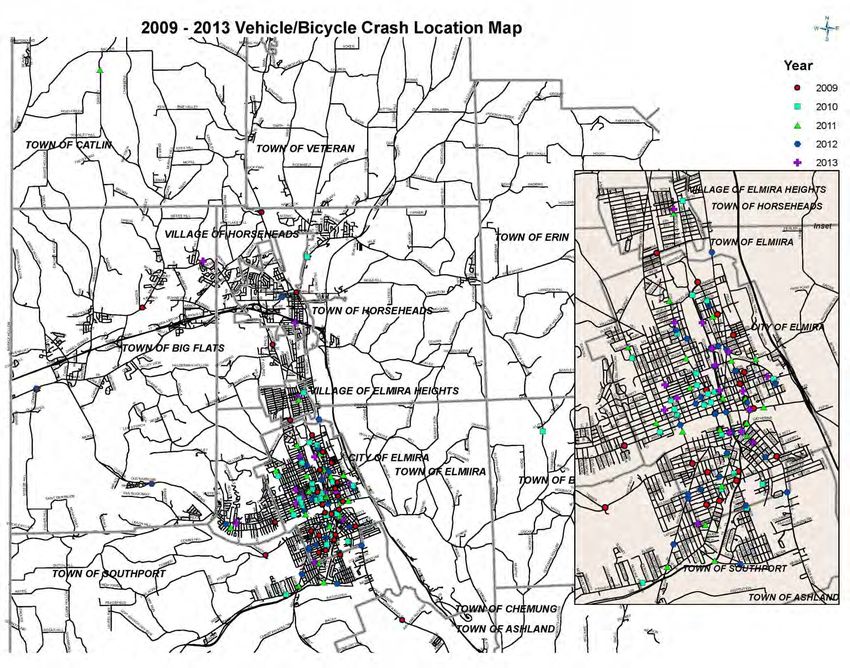
TABLE OF CONTENTS

EXECUTIVE SUMMARY .......................................................................................................................... 1
PUBLIC INTEREST INCREASES and PROJECTS COMPLETED .......................................................... 2
STAKEHOLDER OUTREACH ................................................................................................................... 2
LONG RANGE PLAN GOALS AND OBJECTIVES ................................................................................. 4
EXISITNG CONDITIONS ........................................................................................................................... 6
   SAFETY ................................................................................................................................................... 6
   PEDESTRIAN ACCOMMODATIONS................................................................................................... 6
   BICYCLE ACCOMMODATIONS .......................................................................................................... 8
   TRAILS .................................................................................................................................................. 10
NEEDS........................................................................................................................................................ 13
   SAFETY ................................................................................................................................................. 14
   PEDESTRIAN ACCOMMODATIONS................................................................................................. 18
   BICYCLE ACCOMMODATIONS ........................................................................................................ 19
   TRAILS .................................................................................................................................................. 20
RECOMMENDATIONS ............................................................................................................................ 21
   PARTNERSHIPS AND COLLABORATION ....................................................................................... 21
   SAFETY EDUCATION PROGRAM .................................................................................................... 21
   FUNDING PRIORITIZATION .............................................................................................................. 21
   PEDESTRIAN AND BICYCLE ............................................................................................................ 22
       2015-2019 Recommendations............................................................................................................. 22
       2020-2035 Recommendations............................................................................................................. 24
   TRAIL RECOMMENDATIONS ........................................................................................................... 24
       2015-2019 Recommendations............................................................................................................. 25
       2020-2035 Recommendations............................................................................................................. 29
EVALUATION........................................................................................................................................... 31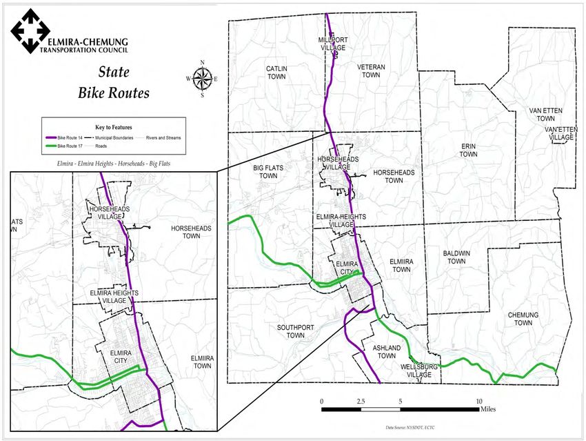
APPENDIX…........................................................................................................................ …………….32
  Accomplishments 2010-14……………………………………………………………………………..33
 B\P\T Partners…………………………………………………………………………………………..34
 BACPAC Members 2014……………………………………………………………………………….46
 ECTC 2014 Bicycle/Pedestrian/Trail Survey…………………………………….……………………. 47
Public Comments Received and Addressed………………………………………………………………48
EXECUTIVE SUMMARY
The Elmira-Chemung Bicycle, Pedestrian, Trail 2035 Plan is a complementary plan to the
“Elmira-Chemung Transportation Plan 2035 Challenges and Opportunities”. This Plan describes
the detailed opportunities and challenges for these transportation modes in Chemung County.
The community has shown increasing interest in efforts to develop a safe, more complete, and
attractive network of sidewalks, bicycle infrastructure, and trails. This Plan documents those
recent efforts and interest, describes more fully the needs, and recommends the steps to achieve
that safer, more complete, and attractive network.

This Plan describes the goals and objectives for the next twenty years for improving the way in
which bicyclists and pedestrians are accommodated on streets, sidewalks, and trails. These goals
address how infrastructure investments will be prioritized to improve safety, promote
connectivity, and ensure the integration of transportation and land use planning. The existing
state of each of the three areas are documented, including physical condition and safety
conditions through documentation of crash data. The Plan discusses the overall unmet needs and
conditions of the three areas, and the low level of specific transportation funding available to
address those needs. Lastly, the plan recommendations are detailed. The key recommendations
can be summarized as follows:

   •   Implementation of a multi-year Safety Education Plan.

   •   Working with municipalities, advocacy groups, the health care community, and other
       stakeholders who have an interest in improving and promoting the use of walking and
       bicycling.

   •   Prioritizing the use of the funding that becomes available to complete as many pedestrian,
       bicycle, and trail infrastructure projects as possible.

   •   Completing a well-defined trail network in Chemung County, using the completed trails
       as a base.

The recommendations are presented separately for the first five years of the plan (2015-2019)
and then for the last fifteen years (2020-2035).

                                               1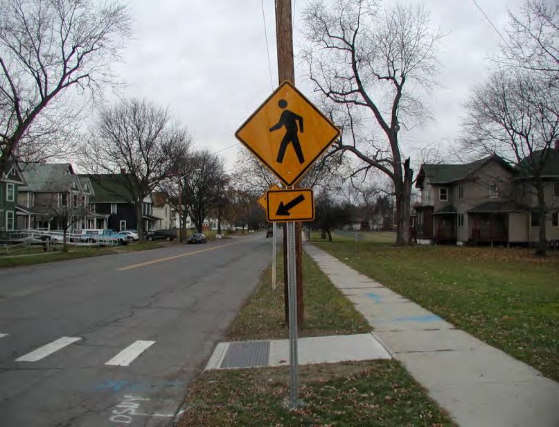
PUBLIC INTEREST INCREASES and PROJECTS COMPLETED
Since the 2009 general Elmira-Chemung Transportation Council Long Range Plan update,
community support has been increasing for improving the quality of life in Chemung County
through increased access to walking and bicycling on its streets and on trails. Over the last five
years significant new pedestrian, bicycle, and trail infrastructure was completed, including:

   •   The Catharine Valley Trail segments in Chemung County to Mark Twain State Park\“The
       Domes”
   •   The Lackawanna Rail Trail from Eldridge Park to Water Street (in Elmira)
   •   Several projects were completed in Elmira and one in Van Etten to make the walking
       routes to local schools safer. A more complete list of accomplishments is provided in
       Appendix 1.

Equally important was the work of non-profit groups such as the Southern Tier Bicycle League
and Friends of the Chemung River Watershed, which increased public interest in these activities
and in completing bicycle rodeos, bike share sheds, boat launch improvements, and numerous
public activities. The Chemung County Office for Aging and Long Term Care and the AARP
Chapter 276 have been active in planning and creating public involvement. Various advocacy
groups, the partners listed above, and the general public have been involved in National Bike
Month (May), National Trail Day, and walk and bicycle to school and work events held every
year. The availability of Federal transportation funding, through the Safe Routes to Schools,
Transportation Alternatives Program; and a New York State Department of Health Creating
Healthy Places grant provided needed funds to make several of the larger projects possible.

STAKEHOLDER OUTREACH
The Elmira-Chemung Transportation Council (ECTC) as part of the larger Long Range Plan
(LRP) effort reached out to the general public and interest groups to provide input for the LRP
and with some specific questions relating to pedestrian, bicycle, and trail focus. ECTC surveyed
the three-county Bicycle Advisory Council and Pedestrian Advisory Council (BACPAC) that it
chairs, the local AARP Chapter 276 members, the annual Southern Tier Central Regional
Leadership Conference attendees, and the public at the summertime weekly Wisner Park
Farmers Market. Over 130 completed surveys were received. A copy of the survey form is
included in this Plan’s Appendix.

Five questions on the larger survey involved finding out more information on walking, bicycling,
and use of the available trail systems. The survey results from these questions show a greater
amount of walking and bicycling than is currently thought in the community, and one supports
one of the goals for projects in the future.

                                                2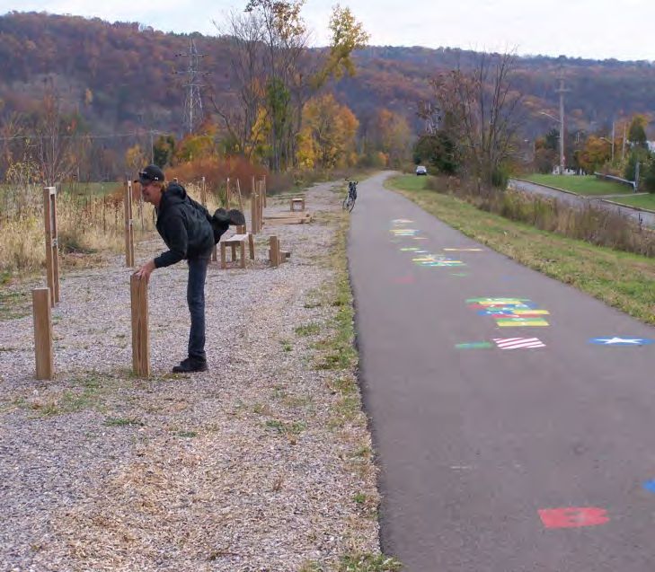
Question 4 – Throughout the year,
how often do you Walk to or from            Question 4: Walking Frequency
work, school, errands, exercise or
recreation, during lunch, or social
activity?

Results indicate that nearly 60 percent
of respondents walk throughout the
year on a daily or weekly basis while
30 percent said they either rarely or
never walk.

Question 5 – Throughout the year,
how often do you Bicycle to or from
work, school, errands, exercise or          Question 5: Biking Frequency
recreation, during lunch, or social
activity?

Nearly one third of respondents
indicated that they somewhat
frequently or frequently bicycle
throughout the year, to access work,
school, shopping, or far errands.

Question 7 – What is the purpose of your walking, jogging, and/or bicycle trips and
destinations?

While the majority of respondents said their primary purpose for non-automotive and non-transit
forms of travel is for recreational purposes, a significant seven percent said they walk or bicycle
to work.

In other questions, when asked if respondents felt their existing streets, walking routes, trails, and
New York State designated bike routes in their area felt safe and encouraging, 74 percent said
yes. When asked if they supported connections to the existing trails in Chemung, Schuyler, and
Steuben Counties, 90 percent said yes.

Survey results indicate there is overwhelming support for investment in non-automotive forms of
travel. This suggests latent demand may exist and improving access and connectivity will result
in greater use for both recreational and non-recreational purposes.

                                                  3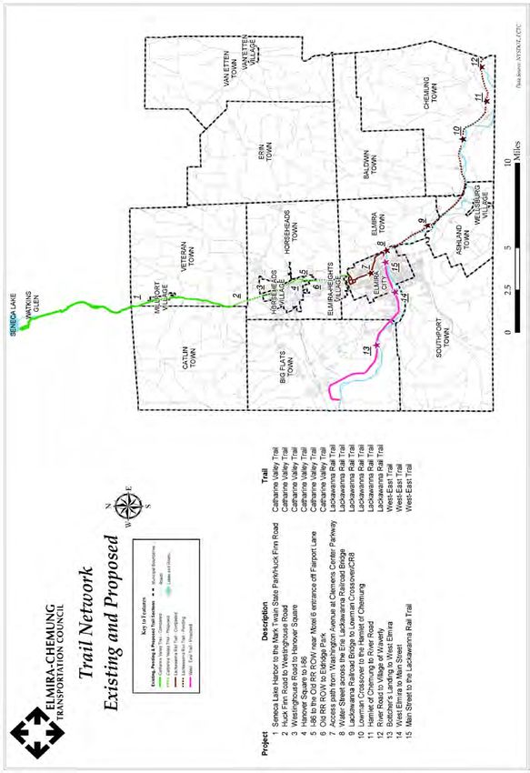
LONG RANGE PLAN GOALS AND OBJECTIVES
Looking at the next twenty years, goals and objectives were developed for all modes of
transportation in the Long Range Plan. As part of the LRP, goals and objectives relevant to
“active transportation” and Complete Streets were developed. They are based upon public and
interest group input for the past five years, and the public input at the Long Range Plan
community visioning sessions at the beginning of this process. Those goals and objectives are:

Goal 1: Ensure the safety and security of the transportation system for all users. Safety is
fundamental to all transportation agencies and to all users of the transportation system. ECTC is
committed to monitoring the system in order to make investments that improve safety and
security for drivers, transit riders, pedestrians, and cyclists, along with the work force that runs
and maintains the system.

       •   Objective: Maintain the low number of pedestrian crashes that result in death or
           personal injury in each five year period from 2020 to 2035, using 2015 to 2019 as the
           base five years.
       •   Objective: Maintain the low number of bicycle crashes that result in death or
           personal injury in each five year period from 2015 to 2035, using 2010 to 2014 as the
           base five years.

Goal 2: Invest in the transportation system infrastructure to bring all facilities and modes
into a state of good repair. ECTC is committed to continuously evaluating the condition of our
roads and streets, bridges, sidewalks, transit buses and facilities, traffic signals and other devices,
utilizing an asset management approach in order to bring them to a state of good repair.
        • Objective: Inventory the sidewalk conditions starting in Elmira and pedestrian and
            bicycle use counts to determine the corridors where investment in Complete Streets is
            of highest priority.
        • Objective: Improve sidewalk condition and ADA compliance for publically owned
            and maintained as streets and roads are reconstructed.
        • Objective: Improve safer bicycling access through striping wider shoulders, bike
            lanes, shared lane pavement markings (“sharrows”), or construction improvements.
        • Objective: As a product of Goal 4 planning, incorporate Complete Streets elements
            in street and other transportation infrastructure projects.

Goal 3 (# 4 in the LRP): Promote connectivity among all modes of transportation to meet
the region’s mobility and accessibility needs. In order to have a vibrant community, people
and goods need access to their destinations. ECTC recognizes that a well-connected multimodal
transportation system serves vital needs.
       • Objective: Identify discontinuities in sidewalks, bicycle facilities, and trails and
            document areas where projects are needed to create active transportation corridors.

                                                  4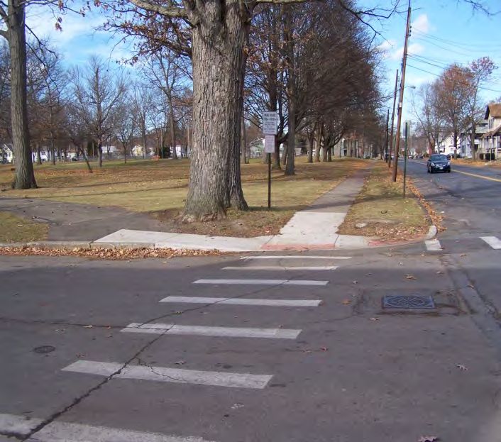
•   Objective: Complete links to the trail network set forth in this plan.
       •   Objective: Partner with advocacy groups, public agencies, health care organizations,
           and others to market and otherwise promote the use of walking and bicycling in
           Chemung County.

Goal 4 (#6 in the LRP): Integrate transportation and land use planning to promote
economic development, sustainability, and enhanced livability. ECTC supports the close
collaboration of land use and transportation planning as the means to take mutual actions that
enhance the prosperity and quality of life throughout the planning area.

       •   Objective: Identify transportation improvements that will improve neighborhood
           quality of life. For Federal aid–eligible highways and bridges, Complete Streets
           treatments will be considered based on the New York State Complete Streets law,
           using the NYSDOT policy and review criteria starting with the next TIP in 2016.
       •   Objective: Provide Complete Streets training through formal presentations and
           public information sessions.
       •   Objective: Municipalities adopt Complete Streets policies for the roads and streets
           for which they are responsible.

                                              5
EXISITNG CONDITIONS
SAFETY

ECTC has been collecting and cataloging crash data for over ten years. On several occasions,
bicycle and pedestrian crashes with vehicles have been given special attention due to fatalities or
serious injuries, or numerous crashes involving these two modes. ECTC has worked through the
Chemung County Traffic Safety Board to bring the number and locations of these crashes to law
enforcement‘s attention.

The current source for crash information is the New York State DOT’s Accident Location
Information System (ALIS). ALIS is a multi-agency collaboration to develop a GIS-based
method for querying and graphically displaying crash data. It combines several state
organizations’ information systems to improve the location accuracy and streamline the
processing of traffic accidents. A centralized Accident Location Server automates the location
processing of electronically transmitted accidents. ALIS is based on the ESRI ArcGIS platform
and supports 14 different location methods to support a variety of input location data. The system
leverages a state-wide Geodatabase (New York State Data Product) that was designed to
improve location of accidents and at the same time be a comprehensive data set to be used more
broadly in the New York State GIS community. The resulting accident location data is available
for highway safety applications in New York State.

Once locations of serious or numerous crashes are identified, appropriate countermeasures
including roadway improvements (better signage, lighting, or drainage), or behavioral changes
(increased law enforcement, education) may be taken.

PEDESTRIAN ACCOMMODATIONS

The municipalities in Chemung County have not created a detailed sidewalk inventory.
However, the following observations provide context for pedestrian facilities. As is common in
New York’s metropolitan areas, there are sidewalks throughout the City of Elmira. There are
some sidewalks in the suburban communities of Horseheads, Big Flats, and Southport, and also
in the Village of Van Etten. There are few sidewalks in other suburbs and virtually none in rural
areas. In 2013 the Town of Chemung was awarded a $600,000 FHWA Transportation
Enhancement Program grant for sidewalk construction. The project will result in the
construction of sidewalks on several streets within the hamlet of Chemung. The sidewalks will
be constructed on main streets and provide good walking access to the Chemung Elementary
School on North Street in the hamlet.

The Americans with Disabilities Act (ADA) requires that public accommodations be fully
accessible to persons with disabilities. As a result, sidewalks must be constructed so they can be

                                                6
safely navigated by individuals with physical and visual impairments. Sidewalks must be of
adequate width and slope. Intersections must be equipped with ramps so people who use
wheelchairs or with mobility aids are not faced with a curb they cannot negotiate. The ramps
must have a tactile surface so visually impaired people who use a cane or other navigational aid
can find them. The ramps should also be oriented at 90º to the curb, positioned so people will
walk directly into the crosswalk.

The City of Elmira has done a good job of constructing ADA ramps throughout the downtown
and along major arterial streets like Church Street, Water Street and College Avenue.
Unfortunately, many of these ramps are not oriented correctly based on current standards, with a
single ramp oriented at 45º to both streets.

While there are some sidewalks in suburban communities, it is often the case that subdivisions
built around the villages were constructed without them. The lack of sidewalks discourages
walking, since people must choose to walk in the street. While this may be relatively safe on
low-volume residential streets, it is less so on busier collector and arterial streets, which must
often be used to reach a desired destination.

Two interconnected one-mile Downtown Elmira Walking Routes have been developed by ECTC
to encourage lunch time and other walking by area employees. The intent is to generate physical
activity and its associated health benefits. The Walking Routes consist of painted foot prints on
the sidewalk that the public can follow to walk one mile. Four one-mile Walking Routes were
designed for the Village of Horseheads. Further work on the Horseheads routes is needed to
mark and promote them.

Traffic signals are also an important contributor to pedestrian safety in more densely populated
areas, such as the City of Elmira. The Manual on Uniform Traffic Control Devices (MUTCD)
includes a series of warrants that spell out where it is appropriate to install traffic signals. These
warrants are based on traffic volume, pedestrian volume, or documented safety problems that can
be solved by a signal. There should be pedestrian signals where volumes warrant them; current
standards in New York are for these signals to include countdown timer displays. Elmira has
sufficient signals for pedestrian safety purposes. The City is in the final phase of upgrading its
signal technology and has eliminated signals where they were not warranted by the MUTCD.
Traffic signals may be made accessible to the visually impaired by use of a locator tone on the
pedestrian button, and a voice message that states which street is being crossed and whether it is
ok to cross, or to wait for the green light. In the City there is only one ADA accessible pedestrian
signal, located at the intersection of Church Street and Clemens Center Parkway. It only emits an
audible signal to cross Clemens Center Parkway.

The public perceives there is a pedestrian safety and access issue to enter the Clemens Center for
the Performing Arts from the east when there is a performance there. Based in part on the
location of parking, the public routinely raises the need for safe mid-block crossing from the east

                                                  7
into the Clemens Center’s entrance. This is an issue that has been considered for several years
without a reasonable solution becoming apparent to traffic engineers.
Sidewalk maintenance is typically the responsibility of the adjacent property owner. Such
maintenance responsibilities include repairing or replacing damaged sidewalks, and clearing
snow and ice. When NYSDOT constructs sidewalks as a part of a roadway project, maintenance
responsibility is given to the municipality where the roadway is located. Normally, the
municipality then turns the maintenance requirement over to the adjacent property owner.
Likewise, municipal built sidewalks are usually maintained by the adjacent property owner.
Some sidewalks in the City of Elmira, particularly in the downtown, are owned and maintained
by the City.
BICYCLE ACCOMMODATIONS
The New York State Vehicle & Traffic Law authorizes cyclists to ride on all public roads except
Interstate Highways, and where they are specifically prohibited by signage. Bicycles can be
accommodated by striped lanes with appropriate pavement markings, wide curb lanes, or paved
shoulders. While none of these are required, cyclists often feel safer when they have a designated
place to ride.
There is a network of New York State Bike Routes that are designed to facilitate both long
distance and local touring. Two of them run through Chemung County: NYS Bike Routes 14 and
17. These are signed, on-road facilities. NYS Bike Route 14 is a north-south route extending 95
miles from Sodus Point on Lake Ontario to the Pennsylvania border where it connects with
Pennsylvania Bike Route G. It goes through Chemung County from Millport through Elmira to
Southport, following NY State Route 14, Watkins Avenue/Madison Avenue, Pennsylvania
Avenue, and again NY State Route 14.
State Bike Route 17 crosses the state from the Hudson Valley to Lake Erie. In Chemung County,
it runs along the Chemung River from Botcher’s Landing through Elmira and Wellsburg and the
neighboring Tioga County border community of Waverly, NY, where it passes closely by
Pennsylvania Bike Route J. NYS Bike Route 14 and 17 specific routes are shown on Figure 1.
Other than on the NYS Bike Routes, and the major streets of Church and Water, there are limited
streets where a wide striped shoulder is provided as a bicycle lane. There are “Share the Road”
signs on several of the main streets in Elmira. They are located on North Main Street, Church
Street, and Water Street. These sign locations were developed through analysis of the bicycle
crash data and input of the bicycling community that participate in BACPAC and the City of
Elmira Department of Public Services (DPW). The City of Elmira also placed signs on several
streets to discourage bicyclists riding on the wrong side of the road into vehicle traffic (“Wrong
Way”, “Ride with Traffic”).
8Figure 1: State Bike Routes in Chemung County
9A traffic control issue that can have a negative effect on cyclists is the use of actuated traffic
signals. Actuation is often used for side streets and turn lanes, and sometimes for all lanes. The
typical loop detector cannot detect a bicycle. If there are no cars present, the cyclist will not
receive a green light. Special loop detectors have been developed that are sensitive enough to
detect the small mass of a bicycle. These loop detectors have been installed at intersections along
East Church Street. They are accompanied by a pavement marking that shows the cyclist where
to stand to be detected.
Secure bicycle parking is important to cyclists; they may choose not to make trips to locations
where they cannot leave their bicycle in a safe place, There are bicycle racks located throughout
the City of Elmira that provide bicycle storage near transit facilities, in public parks, and at other
points of interest in the municipality.
The Chemung County transit system (C TRAN) has had a policy of providing bicycle racks on
all new buses purchased since 2010. Currently 19 buses of the 30 bus fleet have bicycle racks.
These 19 buses represent the vast majority of the buses that are used in fixed route service. The
racks can accommodate two bicycles and make longer trips more attractive to cyclists when they
can easily use the bus for part of their journey.
TRAILS
There are two long multi-use trails in Chemung County: the Catharine Valley Trail and the
Lackawanna Rail Trail. These two trails are complete enough to be useful trails but they have
not been fully completed within their original scope. There are additional sections that have been
planned or are ready for construction. The Catharine Valley Trail is owned by New York State
Office of Parks, Recreation, and Historic Preservation (State Parks), except for a section on the
northern end which connects the trail to Seneca Lake Harbor. State Parks prepared a revised trail
plan that takes the trail from Watkins Glen in Schuyler County to Millport in Chemung County
and then to Mark Twain State Park\Huck Finn Road at “the Domes”. There is reconstruction
work to be done to repair a washed out area between Smith Road and Clair Street in Pine Valley.
A trailhead at Huck Finn Road is also planned. The original master plan for the trail was to take
the trail further south from Huck Finn Road to the destination of Hanover Square in the Village
of Horseheads.
The Lackawanna Rail Trail (LRT) trail surface, from Eldridge Park to Water Street, was
completed in 2012. Additional work on the landscape bordering the trail has been undertaken by
the City of Elmira. Other improvements to the trail have been performed by the City. A group of
LRT advocates from non-profit organizations, to business, and interested citizens has been
formed by the City to help plan, implement, and fund some additional improvements. As will be
described in more detail later, a project to complete a LRT small section over the Erie Railroad
10Bridge south of Water Street is under construction, and funding is in place to build a new five-
mile section from that bridge to Chemung County Route 8 in Lowman.
There are several shorter multi-use trails and walking routes that are complete and in use:
• Town of Chemung White Wagon Park and 1.2 mile Junction Canal Towpath Trail: The
Town of Chemung was able to complete this park and trail along the south side of the
Chemung River, with funding from Casella Solid Waste, CVS, and two New York State
Senators.
• Sperr Memorial Park, with a half mile trail in the Town of Big Flats is a community park
built in memory of a State Police officer slain in the line of duty.
• Village of Horseheads “linear park” is a trail paralleling I-86 and an asset for the Village
of Horseheads.
• Downtown Elmira “blue and red footprint” one-mile walking routes.
• Other walking routes and trails, such as the gems in Tanglewood Nature Center.
The locations of many of these and other trails and walking routes are shown on Figure 2.
There is one effort that is in the early planning stage. The Town of Southport’s Comprehensive
Plan that was adopted in 2014 includes:
• A goal to increase the sidewalks around the town center and schools.
• A goal to encourage the development of walkable, connected neighborhoods
• One of the results of the Community Survey that was part of the plan effort was that 75%
of respondents “perceived a need for additional bicycle and pedestrian trails”.
Southport is currently considering some proposals to achieve these goals.
Through public feedback it is clear that the current trails are not well known in the community.
There have been efforts made to make them known. There have been newsletters and brochures
distributed by the Friends of the Catharine Valley Trail to market that trail. A brochure was
created and distributed for the Lackawanna Rail Trail.
11Figure 2 Walking Routes and Other Recreation Trails in Chemung County
12NEEDS
Preparing a bicycle and pedestrian plan creates an opportunity to address the interrelations of
transportation with multiple disciplines and quality of life issues. Transportation decisions have a
significant impact on improving public health, making land use decisions to support community
goals, enabling economic development, and meeting the needs of the entire population, including
the growing aging population. It is important to understand the need to develop and maintain
partnerships, working together with agencies, organizations, and individuals of multiple
disciplines to enable the accomplishment of each other’s complementary goals and objectives.
As an example, the various partners working together are responsible for achieving the
underlying accomplishments since the last Long Range Plan in 2009.
Furthermore, there is a need for a culture change in which walking is recognized as a viable
mode of transportation, the rights and responsibilities of pedestrians are recognized, and
providing pedestrian facilities is seen as important to the construction of transportation facilities
and maintaining them in a state of good repair.
Infrastructure improvements to the transportation system to safely accommodate pedestrians by
including elements such as sidewalks, high visibility crosswalks, and the latest pedestrian
crossing signal technology must also be combined with education, encouragement, enforcement,
and evaluation efforts to accomplish the culture change.
The next step in the planning process is to develop a menu of needs. These needs are categorized
in a similar fashion to the LRP goal statements and address connectivity to enhance mobility,
accessibility, and safety of all modes and diverse users. In this way, it is clear that pedestrian
safety will be addressed differently than automobile safety, and accessibility for transit users and
cyclists will be based on different criteria.
The need for safety education on how to safely walk to your destination and how and where to
bicycle safely is a priority, based upon the crash data. The needs of this plan are based on the
following:
• Safety for all users;
• Analysis of the gaps between current conditions and future use\need;
• Absent survey data, anecdotal evidence to lead to surveying and studies; and
• Meeting ECTC’s goals and objectives stated above.
The enumeration of needs is not initially constrained by financial resources; that will occur when
proposed projects, actions, and strategies are devised to meet the needs. There is not currently
enough Federal funding to meet all transportation needs over the next 20 years. However, it is
not known how many of the identified pedestrian and bicycling needs can be met as part of
Federally-funded highway and bridge projects and how much local and other grant funding will
13be available. The objectives of this Plan will help establish priorities that identify the most
pressing needs and further planning and study will be needed to refine the recommended actions
into viable projects.
SAFETY
Safety is considered the highest priority of the ECTC because of the human cost that results from
crashes and related incidents. Safety extends across all modes of travel. Roadway safety is of
concern because of the consequences of crashes in terms of fatalities and serious injuries to
motorists, cyclists, and pedestrians. Pedestrians and cyclists are the most vulnerable in crashes
because they can be injured at relatively low vehicle speeds.
A crash analysis for bicycles and pedestrians was conducted to help understand how the
transportation network affects safety conditions. The most recent crashes involving bicycles and
pedestrians were obtained from the SafeNY crash data 1 repository for years 2009 through 2013
in Chemung County. SafeNY is a web-based tool and is comprised of statewide motor vehicle
crash data summaries. Because comparing crash data by individual years may distort analysis
results, five years of data was analyzed to account for anomalies caused by outside influence
such as construction projects and differences in weather conditions. The critical analysis factors
identified from SafeNY are:
• Number of Crashes;
• Crash Type; and
• Crash Location.
The crash data collected and generated through this assessment was combined to identify and
determine any trends in bicycles and pedestrian accidents involving motor vehicles. The crash
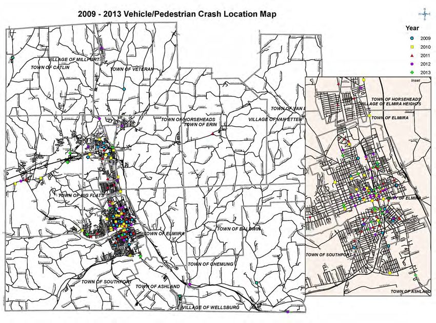
data obtained from the SafeNY revealed that 145 crashes were recorded involving bicyclists
within Chemung County over the five-year period from 2009 to 2013. The crash data also
revealed that 164 crashes were recorded involving pedestrians within Chemung County over the
same five-year period. Figures 3 and 4 identify the locations of each recorded crash involving a
bicycle and pedestrian over the five-year period. Tables 1 and 2 summarize the data by year and
crash type.
1
SafeNY (www.safeny.ny.gov ) is a program of the Governor’s Traffic Safety Committee. SafeNY data source,
which has ALIS data as its base, was used here, but ECTC staff use ALIS directly as noted above
14Table 1: Crashes Involving Bicycles
Chemung County: Bicycle Crashes 2009-2013
# Intersection # of Serious
Year # of Crashes Percentage # of Injuries Percentage Percentage # of Fatalities Percentage
Related Injuries*
2009 30 15 50% 22 73% 7 23% 1 3%
2010 30 22 73% 25 83% 6 20% 0 0%
2011 27 19 70% 20 74% 1 4% 2 7%
2012 38 26 68% 29 76% 3 8% 0 0%
2013 20 13 65% 19 95% 0 0% 0 0%
5 year average 29 19 65% 23 80% 3 11% 1 2%
*note: Severe injuries include skull fracture, internal injuries, broken or distorted limbs, unconsciousness, severe laceration, and unable to leave the scene without assistance.
Table 2: Crashes Involving Pedestrians
Chemung County: Pedestrian Crashes 2009-2013
# Intersection # of Serious # of
Year # of Crashes Percentage # of Injuries Percentage Percentage Percentage
Related Injuries* Fatalities
2009 30 13 43% 26 87% 4 13% 0 0%
2010 31 17 55% 22 71% 5 16% 3 10%
2011 36 22 61% 26 72% 4 11% 1 3%
2012 39 19 49% 31 79% 8 21% 0 0%
2013 28 19 68% 22 79% 3 11% 0 0%
5 year average 33 18 55% 25 78% 5 14% 1 3%
*note: Severe injuries include skull fracture, internal injuries, broken or distorted limbs, unconsciousness, severe laceration, and unable to leave the scene without assistance.
15Figure 3 Pedestrian Crash Locations 2009-2013
16Figure 4 Bicycle Crash Locations 2009-2013
17The causes of crashes in Chemung County result from a combination of many factors including
driver behavior, traffic density, weather and light conditions, and roadway geometry.
Approximately 80 percent of all crashes involving bicyclists and pedestrians resulted in injuries,
with 10 to 20 percent resulting in serious injury. Over the five-year period, three (3) bicycle
fatalities and four (4) pedestrian fatalities were reported.
The analysis results do not suggest specific locations or intersections that need additional safety
measures. There is not a location where the number and seriousness of crash information
demonstrates a need for specific engineering improvements. However, based upon the number
of fatalities and serious injuries for pedestrians and bicyclists for the population of the County,
additional public safety education appears warranted.
It is important to continue to protect pedestrians and cyclists by providing both proper
infrastructure, like pedestrian countdown signals and crosswalks, improved accessibility and
connectivity, and continued public education and awareness.
PEDESTRIAN ACCOMMODATIONS
Sidewalks are an important part of transportation system infrastructure often overlooked.
Sidewalks provide a safe place for people to walk. When sidewalks are not present, pedestrians
must walk in the street and compete with vehicles. ADA imposes requirements on public rights-
of-way to facilitate the safe travel of individuals with mobility or visual impairments. As noted
earlier, the City of Elmira has updated its ADA compliance at intersections in the Elmira Central
Business District on Church and Water Streets with its recent street projects. There remain needs
in the vicinity of schools, health care facilities, transit routes (including pads at bus stops to
accommodate deployment of wheelchair ramps or lifts), and other major pedestrian generators.
To set a base level of need for pedestrians of all abilities to walk safely in an area, there must be
sidewalks. In meeting the objective needs of pedestrians, sidewalks should:
• Provide access to desired locations, including businesses, schools, parks, and cultural
facilities;
• Be of adequate width, and in an acceptable state of repair; and
• Meet the requirements of the Americans with Disabilities Act (ADA) for accessible
public facilities.
Sidewalk maintenance and clearing are typically the responsibility of the property owner.
As public health partners are encouraging more physical activity for both children and adults,
safe places to walk become more important. Safe Routes to School programs encourage families
to have their children walk to school. In order to do so, there must be sidewalks present in a
predefined radius around all schools, as well as crosswalks at intersections.
18Transit is always a multimodal trip, as people must walk to and from bus stops from their trip
origin and destination. While most of C TRAN riders are captive, meaning that transit may be
their only trip choice, there are also choice riders. In either case, people should not be expected
to walk in the street to catch a bus. There should be sidewalks within one-quarter mile of bus
routes to ensure the safety of transit users.
It is also important that there be sidewalks and crosswalks in the vicinity of other major
pedestrian generators, including retail districts, healthcare facilities, and parks and cultural
resources. The City of Elmira has a decent network of sidewalks in its downtown district. The
City has an outstanding local park system that supports neighborhood quality of life. Providing
safe access for families and children is a necessary component of park utilization. Pedestrian and
bicycle access and safety have been improved at three parks in the City through the Arnot
Hospital’s Creating Healthy Places Grant. Cautionary “park” signs and suggested speed limit
signs, new crosswalks painted, and some sidewalk intersection improvements were completed.
Bicycle racks were installed. There are many other City parks where there were not sufficient
funds to make these improvements.
The Downtown Walking Routes in the City of Elmira should be refurbished. The Horseheads
Village Walking Routes need to be marked and marketed. The need for any additional walking
routes should be decided by the municipality
BICYCLE ACCOMMODATIONS
The infrastructure to support bicycle transportation that meets residents’ basic needs for work,
shopping, medical appointments, and other important trip purposes is limited. It is also not clear
what the best path is from residential areas to the “need” destinations.
There are two NYS Bike Routes that travel the whole length of the County; one north-south and
the other east-west. New York State Bike Routes 14 and 17 run through the community and
provide some accessibility for long-distance recreational travelers.
There are not any designated local bicycle routes in Chemung County. Local bicycle routes can
serve the purpose of directing cyclists to streets that are deemed safe and convenient. Like auto
drivers, cyclists travel from many origins to many destinations. They may not be able to
complete their entire trip on designated local bicycle routes, but they can select them for
appropriate segments. Streets that are selected as bicycle routes should have adequate width and
geometry to safely accommodate cyclists. Signing would be deployed, and striping of bicycle
lanes considered.
When considering what are the bicycle infrastructure needs in the county, there is limited
treatment beyond shoulder striping. On-road bicycle facilities may include a number of
treatments, including:
19• Striped bike lanes;
• Shared lane signs and pavement markings (“sharrow”);
• Wide shoulders on roads without curbs; and
• Wide curb lanes on urban streets.
TRAILS
The current trails are a good start; however, there needs to be a trail network to be a more
effective transportation resource. Longer trails, with more public destinations, make for a better
quality of life for the community and a better tourist attraction. Trail improvements are needed:
increased access from the sidewalk and road network, benches, bike share stations, and
information kiosks with current trail information.
20RECOMMENDATIONS
The following are recommendations to meet the goals and objectives of this Plan considering the
desires of the community, the existing conditions, and the needs identified in the areas of overall
safety, pedestrian, bicycle and trail transportation.
PARTNERSHIPS AND COLLABORATION
In order to achieve the recommendations detailed here it will be important to maintain and
extend the existing partnerships among the various municipalities, organizations, the health
community, businesses, and citizens and collaborate with new partners. The Chemung,
Schuyler, and Steuben Bicycle Advisory Council and Pedestrian Advisory Council (BACPAC),
chaired by ECTC, will need to continue to be an effective group to set regional and Chemung
County-specific goals and to work with the members to achieve them. BACPAC has the
important roles of supporting bicycle and pedestrian policies and projects in all three counties
and as a place to share what is happening among all three counties’ members. The partnership
groups are listed in Appendix 1.
SAFETY EDUCATION PROGRAM
ECTC will develop a safety education program to provide the community with the information to
make their walking and bicycling safer and more enjoyable on the streets and roads in the
County. The ECTC staff, and in some cases their partners, will use training, brief presentations
at schools, health care groups, and seniors groups to deliver the safety messages. The program
could include the use of Public Service Announcements, visual displays, and marketing
giveaways. The program will also include more technical presentations of bicycle and pedestrian
crash data to groups such as the Chemung County Traffic Safety Board. This will be a multi-year
effort. The need to continue or change safety message will be evaluated near the end of the
2015-2019 period. The plans for safety education for the subsequent five years (2020-2024) will
be developed then.
FUNDING PRIORITIZATION
There is not enough Federal transportation funding available to the areas in Chemung County
through ECTC to complete any major stand-alone Complete Streets projects. However, it is
recommended whenever feasible that Complete Street elements be included in Federally-funded
street or road resurfacing and rehabilitation projects. These may include improved and repaired
sidewalks, improved ADA-accessible intersection ramps, curb extensions or “bulb outs”, needed
crosswalks, bike lanes, and other bicycle accommodations To the extent that street projects are
100% locally funded, such accommodations should also be seriously considered where there is
demonstrated pedestrian and bicycle use at nearby destinations.
21To this point, funding from the FHWA Transportation Alternative Program (TAP), and its
predecessor the Transportation Enhancement Program, has been primarily used to fund trail
construction. The Recreation Trails program, which is now part of TAP, has been used only
once, for the bridge improvement project part of the Lackawanna Rail Trail. It is recommended
that ECTC encourage municipalities to set a balanced priority between sidewalk and bicycle
capital projects and trail projects when applying for TAP funds. ECTC should encourage the use
of TAP/Recreational Trails program funds for trail development.
PEDESTRIAN AND BICYCLE
In terms of recommendations these two modes are combined in large part because the
improvements will involve the same streets. While the crash data will be reported separately, it
comes from the same source, and the Federally-mandated performance measures are likely to be
the same: fatalities and serious injuries caused by crashes.
The recommendations are divided into those recommended to be undertaken and completed in
the first five years, and those recommended for the next fifteen years thereafter.
2015-2019 Recommendations
The 2009-2014 crash data collected by ECTC will be used as the base data to compare future
data for trends. The bicycle and pedestrian data will be part of the overall ECTC vehicle crash
data collection effort, but separate bicycle and pedestrian data sets and summaries for crashes
involving total crashes, serious injury crashes, and number of fatalities will be prepared and used
as appropriate. It is expected that the number of significant crashes will continue to remain low.
The data collection approach will be refined, as needed, as it is collected and reported upon for
the 2015-2019 period. If there are crash trends at specific intersections or types of intersections,
remedial actions will be recommended. The efforts here will be further refined as the Federal
regulations concerning safety performance measures and reporting are finalized.
ECTC will attempt to collect pedestrian and bicycle usage data in the City of Elmira to determine
the level of use and location. ECTC will encourage the City of Elmira to complete a sidewalk
inventory that includes location, condition, width, and ownership. This is envisioned as a GIS
based data repository. To the extent that ECTC planning funds are available it will assist the
City in its efforts, especially in major transportation corridors for these two modes. ECTC will
encourage and support any efforts by the City of Elmira to develop a sidewalk improvement
program. The combination of pedestrian usage data and the inventory should help direct program
priorities. The bicycle use data may be used to justify the improvement of bicycle access in the
more heavily used corridors. The City recently received a grant to develop their Comprehensive
Plan. ECTC will provide technical assistance and support to the City for the pedestrian, bicycle
22use, zoning, and Complete Streets supportive policies as part of its Comprehensive Plan
development.
ECTC will support efforts by the Town of Southport to implement a Complete Streets policy and
to implement specific projects which improve the infrastructure to be safer pedestrians and
bicyclists, resulting in greater usage. The Town is currently studying corridors such as Cedar
Street and Pennsylvania Avenue in considering improving bicycle and pedestrian access and use.
Note that, there are no 2020-2035 recommendations for Southport due to fact that the Town is in
its early planning stage.
ECTC will study the feasibility of making road improvements to create a safer north-south
bicycle corridor on the west side of Elmira, through Elmira Heights, to Horseheads. ECTC will
use a low cost consultant study. Until the study is performed it is not clear if such a corridor is
feasible and cost effective.
ECTC and Chemung County Planning staff will develop a Complete Streets education module
for presentation to local city, town, and village elected officials, highway superintendents, and
planning boards. Similar, but briefer, Complete Streets concepts and draft policies will be
presented to individual municipal and public groups as appropriate to encourage the enactment
of municipal Complete Streets policies.
ECTC will continue to chair the BACPAC with a focus on using the varied membership to
support and report on the bicycle, pedestrian, and trail efforts in Chemung County. ECTC will
attempt to specifically involve more partners to support increased and safer walking in the
County. ECTC will continue to support its health community partners in their efforts to increase
walking to improve health as it leads to walking as a transportation mode. ECTC will encourage
input from BACPAC members to help define corridors that would be used by local bicyclists for
transportation to destinations that would take only minor improvements and signage to become
designated local bicycle routes. These will be similar to State Bike Routes, but selected more for
local travel. If the development effort progresses to approval, then one or more local bicycle
routes could be designated and signed.
ECTC will continue to be active in activates related to Creating Healthy Places in the grant’s
final year. ECTC will be an active partner, if a grant is received, in the new State Department of
Health “Creating Healthy Schools and Communities” grant program. ECTC would be active in
the part that is aimed at the Elmira School District and its surrounding community.
ECTC will continue to support the Chemung County Department of Aging and Long Term
Care’s Age Friendly Communities efforts and other efforts including new initiatives to
encourage walking and bicycling and that can help improve the infrastructure for these modes.
232020-2035 Recommendations
The recommendations that can be defined for these later years in the Long Range Plan period are
extensions of the efforts and accomplishments that are detailed for the first five years. However,
it will be important to adopt the planned efforts as things will undoubtedly change in the next
five years. Some recommendations described previously may not be feasible or productive to
pursue, and new opportunities will replace those that fall by the wayside.
Pedestrian and bicycle crash data will continue to be collected, summarized, and reported on a
moving five-year average. How that is shared with the community will depend on the number,
severity, and cause of the crashes. Use of the crash data as a basis for recommended
improvements will continue. The Safety Education Program will be continued, revised, or scaled
back depending upon the number of crashes and the need for continuing education efforts to
reduce crashes.
Updating existing sidewalk inventories, and if appropriate expanding those efforts to other
villages and hamlets in the County, will be performed. The ultimate intent of the continuing
program will be to create a network of sidewalks in these areas suitable for transportation use.
The inventory would take place first, followed by planning for improved network conditions and
completion of these sidewalk construction improvements.
The 20-year recommendation for Complete Streets policy implementation is for ECTC staff to
provide assistance to any municipality that expresses interest in implementing such a policy.
While the term for improving safety and access for all modes may change from Complete
Streets, the intent will remain viable. One of the long term goals is the development of pedestrian
and bicycle friendly corridors in the County, to the point of considering developing an exclusive
use boulevard or two.
ECTC will continue to chair BACPAC with a focus on using the varied membership to support
and report on the bicycle, pedestrian, and trail efforts in Chemung County. ECTC will adapt its
efforts to account for changes in interested agencies, non-profit organizations, and the public.
ECTC anticipates that Federal transportation programs and other grant opportunities will likely
change in the next 20 years. ECTC is committed to tracking all bicycle and pedestrian funding
opportunities and to pursue available funding to meet these identified priorities. ECTC will
continue to take a lead in the safer, better, larger pedestrian and bicycle transportation efforts.
TRAIL RECOMMENDATIONS
The community has expressed its desire to create a connected network of trails throughout
Chemung County for recreation and transportation purposes. The plan presented here is to create
24a north-south trail that leads from Seneca Lake Harbor to Eldridge Park and continue on through
Elmira to Lowman, Chemung, and on to the edge of Waverly in Tioga County. There are core
trail segments, such as the Lackawanna Rail Trail Riverview Section, that are not yet in place,
but will be under construction in 2015-16. A west-east trail is envisioned from western
Chemung County at Botcher’s Landing to West Elmira, then using Water Street to connect to the
Lackawanna Rail Trail at its trail head on East Water Street. Achieving the completed network
will not be easy or accomplished quickly. The following is a recommended approach for such a
connected network. It is presented here for the first time. The focus is on developing new
connecting segments in a way that would make them quicker to implement. The existing
completed trails and the recommended new trail segments are show on Figure 5.
The “plan” presented here is not a firm studied analysis and detailed design plan. Rather it is one
alternative to trail alignment for each trail section. The chosen alignment shows the greatest
promise for full completion. Documenting this trail plan is intended to move the process to a
more specific discussion of how each section can be completed into a desirable network. There
are other trails that have been considered in the past or come up in regional discussion. An
example of such trails are the ones detailed in the 2008 river plan (Chemung River Trail – River
Trail Assessment & Master Plan, January 2008, Haas Landscape Architects) for the south side of
the Chemung River in the heart of Elmira, progressing east to Dunn Field and then to Bradley
Farms. However, the network described here is recommended for completion because it uses
existing completed trails as bases to complete north-south and west-east corridor routes through
the County.
In addition to the creation of the network are two additional recommendations. There should be
a continuous marketing effort to make sure residents and visitors know about the trails (in detail).
This will be a significant effort. Local groups and agencies can be a part of these efforts. The
second recommendation is to implement increased access from the sidewalk and road network to
the trails (in selected locations that the public will use and can use safely), benches, bike share
stations, and information kiosks with current trail information.
2015-2019 Recommendations
Catharine Valley Trail
The State Department of Parks, Recreation and Historic Preservation should complete the trail to
Huck Finn Road at “the Domes”. The trail from Seneca Lake Harbor to the Mark Twain State
Park is nearly complete. The items left to complete are reconstruction of the trail section near
Clair Street in Pine Valley that was washed out by flooding in 2013 and constructing a trail head
at Huck Finn Road. The Friends of the Catharine Valley Trail should continue to support the use,
maintenance, and development of the trail.
25Additional Catharine Valley Trail Segments to Eldridge Park-Lackawanna Rail Trail
The general description of these trail segments is:
• The first segment would use State Route 14 from Huck Finn Road to Westinghouse
Road;
• The second segment would use County Route 67\Watkins Road in the Village of
Horseheads (building sidewalks on the west side of the road) into Hanover Square;
• The third segment would use Main Street to I-86;
• The fourth segment would use the service road south of I-86 to “the old Agway”;
• The last, long segment would use existing right of way to take it to the north end of
Eldridge Park.
The first segment recommended for completion is the one from Huck Finn Road to
Westinghouse Road using State Route 14, which is also NYS Bike Route 14. Because it is a
State bike route, the shoulders are assumed to be wide enough to support safe bicycle use as a
trail. A pedestrian trail would be created on the west side of State Route 14.
The next segment is to study what is needed to complete the pedestrian part of the trail from
Westinghouse Road to Hanover Square. The bicycle portion is again almost completed by the
fact that this segment is part of NYS Bike Route 14. The pedestrian part of the trail could be
accomplished by installing sidewalk on the west side of the road.
The third new segment is from Hanover Square to I-86 using Main Street. This segment too is
part of NYS Bike Route 14. There is existing sidewalk that could accommodate pedestrian use.
Approval by the Village of Horseheads and signage are what is needed to complete this segment.
However, it would preferably be constructed after the first two segments are completed so that
there is a viable completed trail.
The fourth new segment is from I-86 to Eldridge Park. The path of the trail would be to cross
under I-86, use the “local service road” (see map) south of I-86 proceeding west to
approximately the “old Agway” location, and then head south on railroad right of way for
approximately two miles until you reach the north end of Eldridge Park. Existing roads and
paths in Eldridge Park could be used to get the trail to the north end of the Lackawanna Rail
Trail. The first step for this trail segment would be to study what the access is, how it is
available for a trail, and providing cost estimates. It is not clear at this time if ECTC will have
enough planning funds to support this proposed study.
26You can also read