DRAFT Tongariro River Flood Control Scheme - Management Plan for Floodway Maintenance
←
→
Page content transcription
If your browser does not render page correctly, please read the page content below
AF
                      R
                  D
Tongariro River Flood Control
Scheme

Management Plan for Floodway Maintenance

May 2012

Lawrie Donald     Larry Grigg
Zone Manager      Works Supervisor

River and Catchment Services

1. Introduction

Doc # 1972444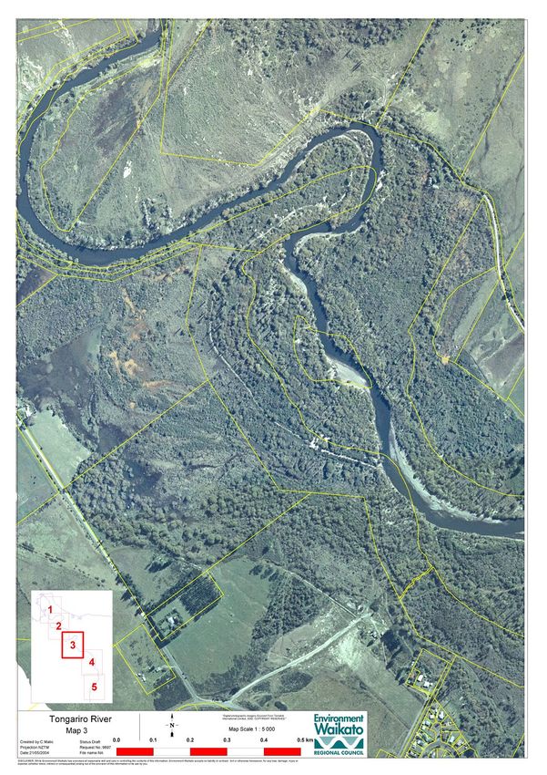
AF
       1.1 Purpose of plan

                              R
2. Catchment and River Description

                         D
       2.1 General Description
       2.2 Established Flood Control Works
       3.1 Description of River reaches
       3.2 The Tongariro River Delta

3. River Management

       3.1 Objectives
       3.2 Monitoring
       3.3 Funding

4. Trigger Mechanisms

       4.1 Objectives
       4.2 Survey and Modeling
       4.3 Assessment of Trigger points
       4.4 Reporting

5. Assessment of Current River Issues May 2011

       5.1 Effected Parties
       5.2 Resource Consents

6. Implementation

       6.1 Identified Works for 2011/12 year

7. Tongariro River Annual Works programme 2012/13
       7.1 Our version of proposed works
       7.2 Scope of silt and gravel extraction
       7.3 Details of extraction operations
       7.4 Herekiekie Street riprap
       7.5 Scope of vegetation management
       7.6 General

Appendix

1. Introduction

Doc # 1972444                                       Page 2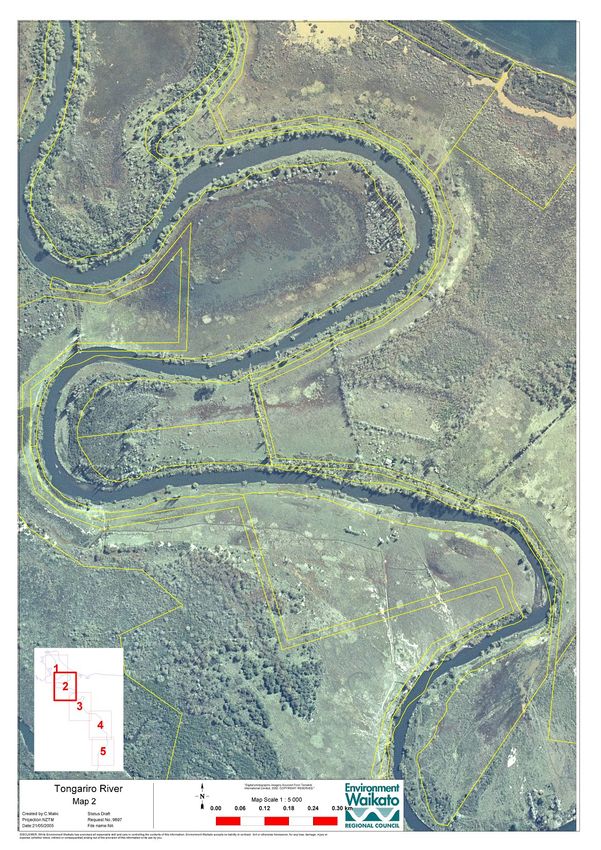
AF
R
.1 Purpose of this plan
D
• To set out the physical works required to achieve the flood scheme
objectives
• To comply with condition 37 of the Resource Consents No 121305 and
121306
• Provide a discussion document for public consultation and effected parties
to liaise with the council.
Waikato Regional Council has constructed a flood protection scheme on the Tongariro River
within Turangi Township to protect people and property from flooding up to a 100-year flow
event (1% Annual Exceedance Probability = 1% AEP) in agreement with the community.
The standard of protection is provided by the formed floodway that includes stopbanks, river
channel, river banks, berms and flood plain. The flood scheme comprises stop-banks for
flood control with erosion control structures to ensure stability of the river banks. To provide
the protection standard is a function of floodway capacity, stability of river channel and banks
as well as the integrity of the built flood scheme assets.
The objectives are to:
Ensure that the floodway is capable of conveying the 100 year flow without
compromising the integrity of the protection scheme.
Manage the floodway to maintain the design freeboard of the stop-banks for the 100
year flow .
Maintain the stability of the river banks where the river floodway is confined between
stop banks for flood control purposes.
Protect the integrity of the flood protection assets, protect property and other
community assets
Proactive operational river management to pre-empt large scale interventions
Minimize impacts on the natural river system
Reduce adverse impacts on the recreational use of the river
Develop contingency plans where required
Communicate our goals to the interested parties
These objectives and associated management requirements are an integral part of the
Tongariro River catchment management and asset management of the flood protection
scheme.
Resource consents were granted in 2011 for the management of the river floodway and were
granted for 20 years for the following activities;
Consent No 121305 Erosion control/flood protection works: gravel extraction up to
150,000cum/year, erosion control works and vegetation removal, temporary diversion
bunds and culvert crossings.
Consent No 121306 Divert water and temporarily dam and divert water within the
Tongariro River.
These consents require that a Proposed Annual Works Plan be prepared and distributed to;
a) Department Conservation
b) Tongariro and Lake Taupo Anglers Club Inc
c) Advocates for the Tongariro River
d) Taupo Fishery Advisory Committee
e) Tuwharetoa Maori Trust Board
f) Ngati Turangitukua
g) Genesis Energy
h) Waipapa and Tokaanu Maori Lands Trust.
2. Tongariro River and Catchment Description
Doc # 1972444 Page 3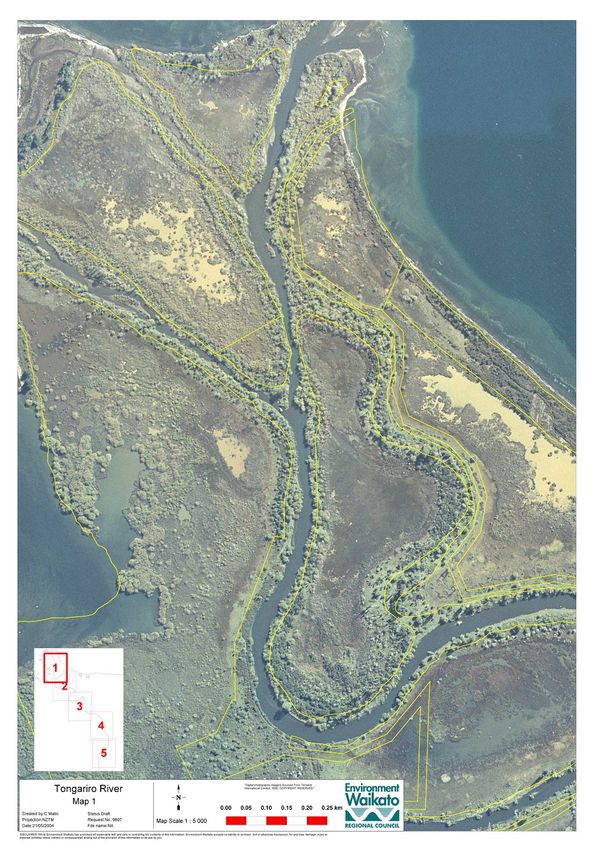
AF
                                 R
       2.1 General Description

                           D
The Tongariro is a volatile river which undergoes significant channel changes in response to
floods and eruptions. The river transports vast amounts of sediment through its upper
reaches and deposits the sediment on its delta from Turangi downstream. (G Smart, NIWA
report CHC2005-002.)

The Tongariro River catchment comprises several main river and stream tributaries,
discharging into the river then directly to Lake Taupo at Turangi. These tributaries come from
such landscapes as the Tongariro National Park, the Kaimanawa Mountains and State Forest
Park and the Umukarikari Range. The river itself is an internationally recognised trout fishery,
management of this fishery resource and large proportions of the upper catchment being the
responsibility of the Department of Conservation.

The river is 92 km long and has a catchment of 791 km2 (Bowler 2002). The river sediment
consists of andesite lava, pumice, and volcanic ash brought from the eastern slopes of the
volcanoes of the central North Island and greywacke, argillite and ash from the Kaimanawa
Range (Smart, 2002) The major part of the catchment is in effect in its ‘natural state’.

The natural hydrology of the river however has been significantly altered by the Tongariro
Power Development (TPD). The average flow in the Tongariro River at Turangi has been
reduced 45% by the TPD (Bowler 2002). Peak flood discharges are not affected greatly
though flood recessions are strongly curtailed by the modifications, this has the potential to
impact on the natural sediment mobilisation and deposition processes in the river.

Turangi Township is located at the head of the alluvial fan the river is developing as a delta
into Lake Taupo. The primary bed material upstream of the alluvial fan is coarse cobble and
boulders. The material deposited in the upper fan is mostly cobble and gravel, with sand and
silt material transported through to the lower fan to be deposited across the floodplain, in the
river meanders and at the river mouth environs.

The deposition of material across the floodplain at the head of the delta is part of the rivers
natural fan building process. Left to its own devices, this deposition process will in the long
term elevate the channel and floodplain and create lateral instability of the channel (again a
natural process). Aerial photography reveals that the delta channel has had a number of
different courses in recent geological history. The requirement to manage the process, and to
stabilise the rivers path, arises with the need to protect property and life in Turangi from flood
waters.

The Tongariro River supports resident and lake migrant rainbow (Oncorhynchus mykiss) and
brown trout (Salmo trutta) populations. The river provides an important spawning and nursery
area and hence is an integral component of the world-renowned Taupo trout fishery.

As well as the trout fishery, the lower Tongariro also supports native fish species, including
koaro (Galaxias brevipinnis), the common bully (Gobiomorphus cotidianus), and common
smelt (Retropinna retropinna) (NZFFD, 2002).

The upper Tongariro River is also very valuable from a conservation and native biodiversity
view point as one of the remaining habitats for the endangered Blue Duck (or whio;
Hymenolanimus malacorhynchos) which is a unique threatened species of waterfowl
endemic to New Zealand. It is the only member of its genus and has no close relative
elsewhere in the world.

       .2   Established Flood Control Works

The capital works of the flood scheme have been established over many years with some
early works in the late fifties and early sixties. To complete the full scheme, minor stop-bank
construction of the Awamete Stopbank is required. This construction is planned once

Doc # 1972444                                                                              Page 4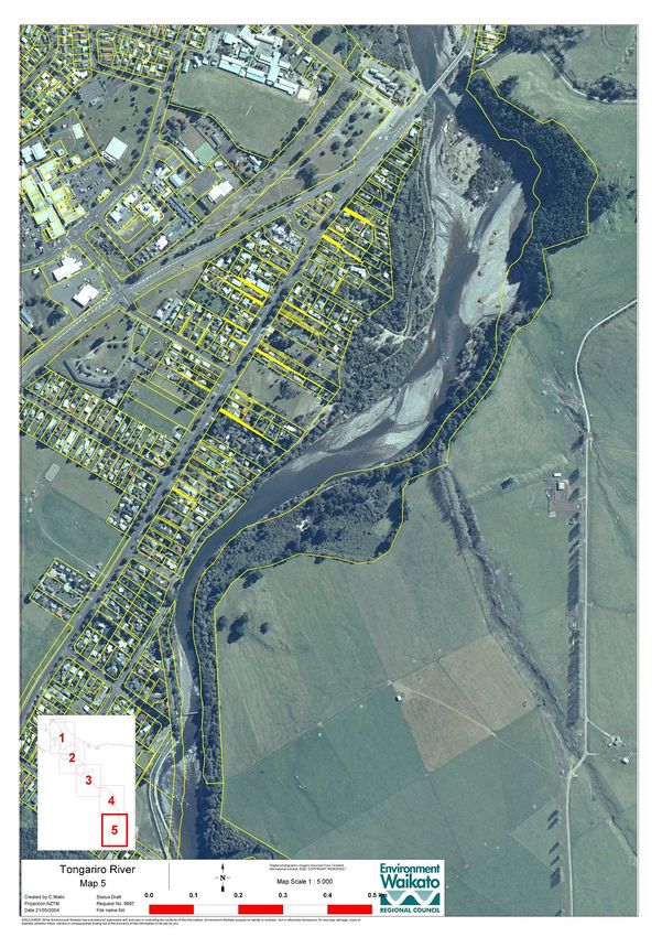
AF
landowner agreement has been obtained. This outstanding construction project is on hold
R
awaiting landowner agreement. This agreement will not be forthcoming until settlement of the
Turangi Ancillary Claim No.8 between Land Information New Zealand acting for the crown
D
and the Maori land owners. The Awamete Stopbank design is complete pending landowner
consultation and agreement.
Ongoing maintenance of established assets is currently managed by Waikato Regional
Council’s Taupo Office based Works Supervisor.
Objectives
The key objectives of Environment Waikato’s Flood Control and River Management works on
the river are;
Provide flood protection to Turangi to the adopted 1 in 100 year flood flow level.
Manage the river floodway to pass the 100 year flood flow
Maintain and enhance the river environment
2.3 Description of River reaches
Upper river (upstream of the Puketarata confluence)
The upper reaches of the river are generally steep and the river is constrained within deep
bedrock gorges with large boulder and cobble substrate. Its steep fast flowing character
provides habitat for the threatened blue duck and also has significant natural character,
recreational and amenity values and has previously been listed as a river of national
importance for its wild and scenic nature. Upstream of map 5
Middle river 1 (Puketarata confluence to Hydro Pool)
The river reach above the Turangi Township is predominantly a single thread channel
meandering within its flood plain. The February 2004 flood resulted in some significant
changes in the channel and activation of a number of erosion sites. Overall it seems that a
significant volume of sediment and debris has been mobilised from within this reach during
the 2004 flood (The higher Lower Tongariro, NIWA Report - CHC2005-002). See map 5
The river values associated are predominantly based on its recreational uses. Its status is as
a world renowned trout fishery with wild and scenic values attracting many visitors all year
round.
Middle river 2 (Hydro Pool to State Highway 1 bridge)
The river upstream of the SH1 Bridge to the hydro pool is relatively constrained within a
boulder and coarse gravel bed. There are left bank erosion protection works with a significant
length of the left bank stop-banked to provide flood protection to Turangi. The right bank is
confined by high ignimbrite bluffs along much of its length. (See map 5) The river
immediately upstream of the SH1 Bridge commences to widen, splitting into two channels
that are separated by a larg stable gravel island.
Probably the most visited and well recognised reach of the Tongariro River. It has extremely
high recreational values as well as a trout fishery of repute. It is adjacent to the upper part of
Turangi Township and supplies very high amenity value to Turangi residents and commercial
operators in the tourism industry. Any river management carried out in this reach must take
account of this high public profile and public access needs.
Lower river (State Highway 1 Bridge to de Latours Pool)
From the State Highway 1 Bridge to Delatours pool a single meandering low flow channel
consists of cobbles and gravel bars confined within a flood plain contained within flood
protection stop banks, bank stabilisation structures, willow infestation and urban
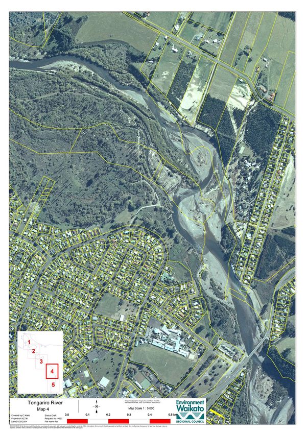
development immediately adjacent the river banks. See maps 3 and 4
Doc # 1972444 Page 5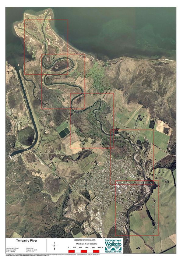
AF
The ‘confined river,’ with pools on the outside of bends and cross over riffles between bends,

                                R
makes this river an extremely highly valued trout fishery and recreational area.

                          D
Below the Swirl Pool exists the site of the former G6 gravel mining area where approximately
700,000 tons of gravel was extracted in the 1960’s and 70’s. Since the gravel extraction
ceased, the artificially lowered river bed has tended to act as a sink for bed load material
entering from upstream during floods. Recent evidence from survey is that the bed has
returned towards more “natural” levels. These “natural” levels may be the upper limit for
management of the flood control scheme.
In October 2010 a series of test pits were dug through this section of the river floodway. The
result of these test pits was that there is very little gravel present away from the river
channel. There is a predominance of fine sandy silt material throughout the floodplain.

    Delta river reach (Delatours Pool to Lake Taupo)
This reach is the lower part of actively forming alluvial fan, and as such can be expected to
be relatively dynamic and unstable on a geomorphologic timescale. The response of the river
tends to be determined by moderate to large floods. The bed material is silt and sand, with
significant volumes of gravels dumped upstream of this reach during major floods.
This lower reach of the river supports outstanding diversity of wetland bird species including
important populations of bittern, spotless crake and fern bird, and a wide range of waterfowl
which are both seasonal and resident.
See maps 1 and 2.

       .3   The Tongariro River Delta

The Delta has significant ecological values as it supports a large area of highly productive
wetland. Geological reports suggest that the delta area is sinking at a rate of 3mm per year.
This subsidence of the area may account for some of the drainage issues and anecdotal
reports of the loss of some past farming practices no longer possible on the delta. As noted
there is a continuous deposition of gravel, sand and silt into the delta river reach. With the
continuation of siltation, the delta will continue to become increasingly wet. Large areas of
willow affect the values of the wetland and exacerbate silt accumulation.

Ngati Turangitukua has identified numerous waahi tapu sites within the delta. Many of these
are at risk of being damaged if a channel breakout occurs. Some of these sites have
received remedial protection measures in the past.
Aerial photography shows that since 1974 a blind channel has grown from the Lake towards
Turangi to a length of approximately one kilometre. It appears that this channel carries flood
flows and continues to grow. There is considered a potential for a permanent breakout from
near Delatours Pool and Awamate Road to join up with this new channel. A breakout of this
nature has the potential to threaten a number of waahi tapu sites and the Turangi sewerage
treatment ponds, although the latter is considered to be at a relatively low risk. A paper by
G.Smart of NIWA (doc #2062662) describes the processes acting in the delta well.
The results of the willow clearing carried out by Ngati Turanitukua from below Delatours pool
are not fully evident yet. These works may mitigate some of the flooding issues in the lower
delta. This will not be known for sometime. There is however riverbank erosion issues
developing through the willow clearance area. Time will tell how this will develop. Early
indications are that the willow clearing does exacerbate river bank erosion with development
of a wider channel.

Doc # 1972444                                                                          Page 6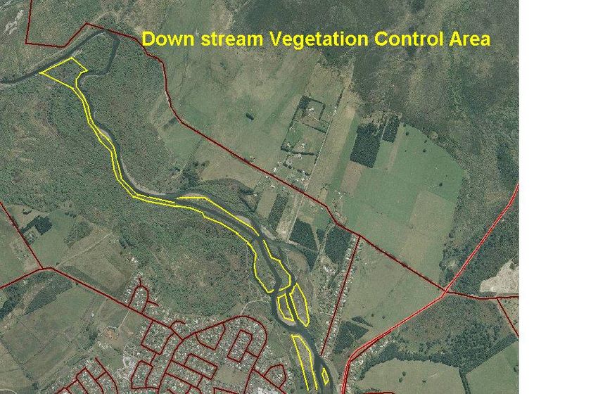
AF
                R
                D

Doc # 1972444        Page 7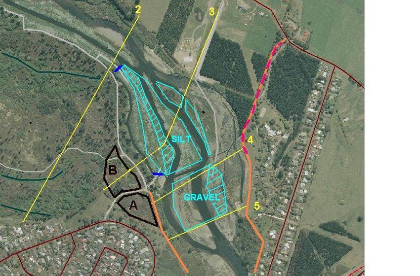
AF
                R
                D

Doc # 1972444        Page 8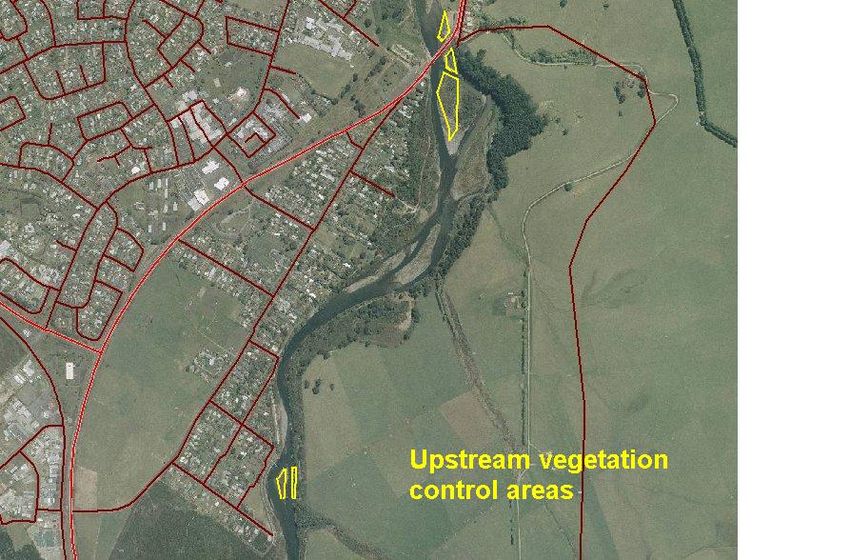
AF
                R
                D

Doc # 1972444        Page 9
AF
R
D
Doc # 1972444 Page 10AF
R
D
Doc # 1972444 Page 11AF
R
D
Doc # 1972444 Page 12AF
3. River Flood Management
R
D
.1 Objectives
Ensure that the floodway is capable of conveying the 100-year flow without
compromising the integrity of the protection scheme.
Maintain the stability of the river banks where the river floodway is confined between
stopbanks for flood control purposes.
Proactive operational river management to pre-empt large scale interventions
Minimize impacts on the natural river system
Reduce adverse impacts on the recreational use of the river
Develop contingency plans where required
Communicate our goals to all interested parties
Provide relief against the frequent overflow of floodwaters for rural land downstream
on the delta. (Note, not to the 100 year protection level)
To achieve these objectives requires that the 100 year river floodway capacity as well as the
design freeboards and all other flood control assets are maintained in a structurally sound
condition and safe from erosion.
.2 Monitoring
River inspections occur on a regular basis for the following reasons;
Annual asset management condition reporting and assessments.
Operational activities throughout the year for asset maintenance
Inspections after each flood event greater than an annual event in the river.
Cross section survey and maintenance work on the established cross sections
Five yearly planned comprehensive cross sectional survey.
Riparian vegetation assessment for management purposes
Flood protection scheme assets are monitored annually with results recorded in councils
Conquest Asset Management Information System. Annual river maintenance works
programs are derived from this inspection information. Works may include vegetation control,
debris and blockage removal and erosion control works.
Five yearly river floodway cross sections surveys are programmed to monitor changes in the
river bed and the flood capacity of the channel. These surveys help determine maintenance
of the channel capacity and are compared with the scheme design to determine that the
current floodway is capable of meeting the objective. Works may include sediment/gravel
removal.
Established cross section alignments will be maintained clear of vegetation to enable regular
checking of the river profile. Unscheduled surveys may be carried out if deemed necessary
by the Zone Manager and/or Works Supervisor. This may occur, for example, following
significant flood events in the river that may have reduced the floodway capacity. These
surveys help with decision making and discussions with Turangitukua, Tuwharetoa and the
Department of Conservation in particular for the management of river gravel/sediment
accumulation.
Physical site inspections are carried out regularly throughout the year and after elevated
flows in the river. Vegetation surveys will be carried out to determine the extent of vegetation
within the river floodway. These inspections and the annual maintenance inspections are
carried out by the Taupo based Works Supervisor.
River shingle/sediment shoals become infested with broom, grey willow and buddleia
seedlings. Very quickly these primary colonizers stabilize the shoals. Stable islands within
the floodway may create diversions of the river flood flows and reduce the river floodway
cross sectional area. Currently strong vegetation has established on the lower river shoals
Doc # 1972444 Page 13AF
requiring removal from the floodway on a regular basis. Management of sediment within the
R
river requires the removal of this vegetation.
D
.3 Funding
The cost of gravel management will fall within the maintenance budget for the Tongariro
Flood Control scheme. Turangi residents who benefit from the scheme pay a targeted rate
for flood protection to Environment Waikato to repay the debt incurred to construct the flood
control scheme and to maintain the scheme.
The fate of any proceeds from sale of any gravel extracted from the river will depend on
negotiations with land owners and interested parties. This matter is outside the scope of this
plan and will be subject to a separate negotiation and agreement.
This Plan is about the technical requirement to manage the river bed level with gravel
extraction essential to that outcome. Any commercial operation based on gravel extraction in
the identified reach of the river may operate subject to this plan.
4. Trigger Mechanisms for Works
4.1 Objectives
(i) The first objective:
Maintain a clear and suitable sized floodway to pass the 1% AEP flow in the river;
This objective requires the following completed actions
Establish cross sectional river bed level survey base line for the ‘flood design’.
Establish bench marks for the survey cross section survey sites
Regular repeat surveys to establish trends and quantities of gravel/sediment
accumulation.
Establish a trigger mechanism to determine the volumes of gravel to be managed
within the river.
Set “trigger” points at which it is essential to remove gravel/sediment or vegetation to
maintain the integrity of the flood scheme and its objectives.
(ii) The second objective is:
Communicate the state of the floodway to community;
This objective requires the following completed actions
A technical report to provide credibility to the decision to remove gravel from the river.
Completed surveys to enable decision making for when and how much gravel/
sediment to remove from the river.
Set trigger levels for action to provide a measurable and defendable reason to
operate in such a high recreational use area.
Completed technical reports to provide a defendable scenario for this operation.
Completion of all of the above to provide peace of mind to the community adjacent
the river.
4.2 Survey and Modeling
Doc # 1972444 Page 14AF
R
A baseline cross sectional survey (Cheals survey of 2000/2001) was used to set the mean
bed level for the original flood scheme design. (Designed Tonkin and Taylor) Tongariro River
D
Modelling, River Management report. (T&T Ref 19882.100)
In 2009/2010 summer a comprehensive survey was carried out by DML on the 2000/2001
established survey cross sections. This 2010 survey has been used to remodel the flood
control scheme and to establish and define trigger mechanisms for the management of
gravel inputs into the flood control section of the river.
At the same time another flood model was also developed for the Tongariro River by the Civil
Defense and Emergency management team of this council. This model was specifically for a
Taupo District Flood Hazard Study for both the Waikato Region and Taupo District councils.
Opus International consultants Limited 2011 completed this report in July 2011. (39C125.N4).
The two models did not agree completely and there has been considerable work carried out
to assess the discrepancies with the two river models. See Theo Sangster report; Tongariro
River Model Update and Flood Management. WRC internal series 2011/October, Doc#
2044169.
This latest report is a complete assessment of all this modeling work to date and is now the
basis for further decisions on the management of the Tongariro River floodway.
4.3 Assessment of Trigger points
“Trigger Levels” for the identification of the need to remove/manage gravel within or from an
area of river have been established.
The trigger levels are based on the established design floodway cross sectional area of the
river floodway.
To be consistent with other stopbank management criteria in the Waikato Region the trigger
mechanism is based on loss of freeboard.
The design freeboard of 300mm above SH1 and 500mm below are adopted levels to safely
pass the 100 year flood flows. Loss of this freeboard or part of this will identify the need for
channel maintenance. A basic assumption is made that the most likely loss of flood way in
the Tongariro Flood scheme will be from infill of gravel/sediment and not subsidence of the
floodwalls or earth fill stop banks. This will be verified from regular 5 yearly surveys of these
parameters.
Recommended Trigger levels;
Minor loss of stopbank freeboard, at any site, initiates an assessment of options.
Moderate loss of stopbank freeboard, at any site requires restoration to design
freeboard.
Major loss of stopbank freeboard at any site initiates “immediate” flood channel
management.
River bank erosion that threatens community infra-structure initiates “immediate”
flood channel works.
Vegetation. Woody vegetation over 1.5 metres in height within the flood way will be
regarded as an unwanted plant. Management of such vegetation will be carried out
on an annual basis through the stop banked river reach.
Remaining freeboard in Remaining freeboard in
reach upstream of SH 1 reach downstream of SH Action Required
Bridge 1 Bridge
Design freeboard. 300mm 500mm No action
Doc # 1972444 Page 15AF
Minor freeboard loss Greater than 250mm Greater than 450mm No action
R
Moderate freeboard L e s s t h a n 2 5 0 m m b u t L e s s t h a n 4 5 0 m m b u t Extract gravel to level
D
loss greater than 150mm greater than 250mm required to restore design
freeboard at next non
spawning season
Major freeboard loss in Less than 150mm Less than 250mm Immediately extract gravel
a storm event to level required to restore
design freeboard
Erosion threatens Immediate mitigation works
infrastructure
Woody vegetation over Immediate mitigation works
1.5m
4.4 Reporting
A river condition report on the above matters and programme of proposed river works to
address any issues will be supplied by the 30 June on an annual basis to the following
parties for information and discussion.
a) The Turangi community ( Tongariro River Management Forum)
b) Department Conservation
c) Tongariro and Lake Taupo Anglers Club Inc
d) Advocates for the Tongariro River
e) Taupo Fishery Advisory Committee
f) Tuwharetoa Maori Trust Board
g) Ngati Turangitukua
h) Genesis Energy
i) Waipapa and Tokaanu Maori Lands Trust
It is recognised that there will be flood events that may pre-empt or occur after the June
reporting. Such events will be dealt with in a similar way; I.e. with prior consultation with the
above effected parties before any major remedial works are carried out.
5. Assessment of Current River Issues May 2012
The river channel position through the flood scheme has undergone many changes in the
past and this can be expected to continue into the future. These changes will depend on the
occurrence of future natural events such as floods, eruptions and major erosion events.
Doc # 1972444 Page 16AF
a) Upstream of Turangi the bed level appears to be relatively stable, no significant
R
changes have been identified in this section of the river. The position of the main
channel will continue to change, as it has done in the past, and variations in bed level
D
can be expected.
b) Downstream of Turangi major changes in the river’s position have occurred.
The February 2004 flood was the largest since the 1995-96 Mount Ruapehu
eruptions. It is estimated (EW document #922125) that around 50,000 cubic metres
of gravel was deposited by the river between SH1 Bridge and Delatours pool. The
volume of sand and finer sediment is unknown but may have been up to ten times
greater than the volume of gravel. The bulk of this material remains and more has
accumulated since this large event.
Gravel and other sediment extraction is a likely activity in this part of the river. This
will require intervention with machinery to maintain a stable river and the design
floodway.
The floodway to Delatours Pool since the former G6 gravel mining area ceased to
operate is infested with willow species that clog the floodway. Willow removal from
here was a programmed activity over the 2011/2012 year. This maintenance of the
flood protection scheme floodway was deemed essential to establishment of a
suitable “coefficient of roughness” to pass the design flood flows.
c) Turangitukua funded through the Ngati Tuwharetoa – Genesis Energy Fund have
undertaken a river bank willow removal programme over the last five years
downstream of Delatours pool. This work has opened the river up creating greater
channel capacity. Some localised riverbank erosion has occurred and it may take
some years for this new river regime to stabilise. Turangitukua will continue with the
management of this area of the river in partnership with Waikato Regional Council.
d) This report relates to the issues in the river that impact on the flood control scheme.
The annual monitoring program identifies loss of floodway capacity and erosion that
may place river assets at risk. Assessment of the risk and the response in the first
instance is managed by the Works Supervisor in consultation with the Zone Manager.
Waikato Regional Council’s Technical team may be called upon, dependent on the
severity or complexity of the issue.
e) The 2009 survey and flood model scenarios of the river channel identified where
sediment extraction would be beneficial. However the initial scope of recommended
extraction activities and some concern with the data used in the model to determine
the scope required further investigation.
f) Sediment extraction separate from gravel extraction is required in the lower river from
the SH1 Bridge to a point 1.2km downstream. This area is a primary deposition area
for sediment and gravel in the delta. The area has had gravel removed in previous
years. A commercial gravel extraction operation in the deposits may be appropriate.
.1 Effected Parties
The main recreational activities that occur over the affected river reach are trout fishing,
mainly in the winter months. In the summer months, contact recreation such as canoeing and
swimming, are additional activities.
In developing works programmes, efforts to ensure major works fall outside the winter trout
spawning season, and when trout fishing activities peak will be done.
Doc # 1972444 Page 17AF
In the unlikely event of in-stream works, these will be generally of short duration and remote
R
from key areas for contact recreation. Appropriate signage will be provided to ensure river
users are warned of the works.
D
Gravel management will be carried out to have minor impacts on effected parties.
As Kaitiaki and Tangata whenua of the area an effected party will be Turangitukua. All works
to manage the river will be carried out in consultation and partnership with Turangitukua and
with Tuwharetoa where applicable as landowner.
A quick list of the identified effected parties
a) The Turangi community ( Tongariro River Management Forum)
b) Department Conservation
c) Tongariro and Lake Taupo Anglers Club Inc
d) Advocates for the Tongariro River
e) Taupo Fishery Advisory Committee
f) Tuwharetoa Maori Trust Board
g) Ngati Turangitukua
h) Taupo District Council
i) Waipapa and Tokaanu Maori Lands Trust
5.2 Resource Consents
Gravel extraction, gravel/sediment management, erosion control works and vegetation
management within the flood way are essential tools to achieve the key objectives of the
established flood control scheme.
Resource Consent Nos 121305 and 121306 for river management (20 year period, expirers
30 June 2031) are in place and cover the following activities;
1. Gravel/sediment extraction.
2 Gravel/sediment management, including minor channel realignment works.
3. New erosion protection works
4. Vegetation removal and planting
5. Debris removal.
6. Maintenance of existing erosion control structures and assets.
7. Maintenance of the required flood cross section, as identified by the 2009/10 survey and
river flood model calibrations. (Trigger levels)
6. Implementation
6.1 Identified and Completed Works for 2011/12 year
• Clear willow vegetation from the floodplain from the Swirl Pool to below Reed’s Pool
• Clear the islands in the floodway from the Swirl pool to the SH1 Bridge of vegetation
higher that 1.5m.
• Clear the major part of the island upstream of the SH1 Bridge of shrubby growth.
Leaving the most established native vegetation on the North east of the island.
• Clear willow vegetation from the alignment of the proposed site to deposit sediment
for protection of Hirangi Stream. (Possible option consultation required).
Doc # 1972444 Page 18AF
• In partnership with Turangitukua to remove 15,000cum of river gravel from below the
R
Swirl pool area of the river.
• Re survey the lower river section (cross sections 1 to 4 of the 2009 survey) to give
D
increased confidence in the modeled need (S Basheer) to remove up to 300,000cum
of sediment from the floodway.
• Re run the model to confirm volumes of sediment to be removed from the floodway.
Note; The above words in red are the activities that did not proceed in 2011/12.
7. Tongariro River Annual Works programme 2012/13
7.1 Our vision of Proposed Works
Works to date have been, in our view, best practice to assist the flood water flows and
minimize predicted flooding of private property on the right bank below the SH1 bridge.
The designed level of flood protection (500mm of freeboard) will hopefully be achieved in
the next 3-5 years by extraction of deposits. The technical report now available identifies
the area around section 3 and 4 as a deposition zone.
The identified works required to establish the design freeboard for the 100 year flood flow
(1%AEP) is the removal of some 50,000cum of sands, silts and gravel from the floodway
below the Swirl Pool. Budget constraints and time constraints preclude this happening within
less than three to five years. The obvious approach for the management of this channel
development work is to stage the works.
Priority works;
1) Willow and vegetation clearance from the floodway. Willow removal will
open up alternative water flow paths to help flood channel capacity.
2) Removal of gravel build up in the channel at and below the Swirl Pool will
lower the mean river bed level increasing the floodway capacity at this location
3) Willow stump removal and sediment removal from the floodway. In the
sites of willow clearance along alternative flood channel flow paths willow stumps will
be removed followed by sediment extraction from the floodway. Large enough
deposition sites for this material need to be negotiated. One of the most likely sites for
placement of this material is on land where the landowners have indicated that they
may be interested, but no discussion will take place until their Ancillary Claims have
been finalized.
4) Awamate stop bank construction will occur as the issues in 3) above do.
The construction of this stop bank is dependent on landowner consent and
agreements. This relies on the settlement of the Ancillary Claims.
7.2 Scope of Silt and Gravel extraction
Map 7
Doc # 1972444 Page 19AF
R
D
The orange lines denote either stop banks or high ground.
The red dotted line denotes the stopbank that is threatened by overtopping in a 100 yr event.
Two dark blue lines under access tracks denote temporary culverts for truck access.
Light blue hatched areas are where extraction will commence.
The black “A” defines a silt dump area which has been recently cleared.
“B” is another possible silt dump site.
7.3 Details of extraction Operation
From technical information developed from the river flood modeling, excavation of bed
material will be required at two locations below the SH1 Bridge.
Silt
At cross section #3 the mean bed level needs lowering by about 0.3m and the section width
here is 600m. This equates to lowering the bed by 1.2m over 150m. About 30,000m³ of silt
between section #3.5 and tapering off to section #2, will require removal.
The shaded blue area is the first stage of silt removal in the dry and will encourage channel
widening during medium flows.
Any willow stumps encountered within the extraction zone during these operations will be
stacked for burning at a suitable time in the future.
We propose to start filling dump area “A” during the winter of 2012. DOC has advised that
although this area is currently administered by them it is in the process of return to
Turangitukua. We have consulted with Turangitukua direct over these disposal sites.
Total area of dump site “A” is about 0.75ha, adjacent to the existing TDC reserve and will
accommodate between 12,000 to 15,000 m³ of material. Decisions about whether this area
will be grassed or planted in indigenous shrubs have not been made.
Some future silt extraction will be required to the Grace Rd side of the river. No disposal sites
have been identified as yet.
Gravel
Doc # 1972444 Page 20AF
Recent channel works have been undertaken to move the main river flows away from the
R
eroding right bank down stream of Tongariro Lodge. This action now provides better access
to the gravel deposits between sections #4 and #5 and has eased the erosion issue
D
occurring along the right bank.
At cross section #4 the mean bed level needs lowering by 0.5m and the section width here is
350m. This equates to lowering the bed by 1.0m over 175m, and tapering off to nil at section
#5 this requires that some15,000m³ of possibly commercial grade gravel will require shifting
from the floodway. It is hoped that this gravel removal can be carried out as a commercial
operation via the WRC access road for processing off site. It is proposed that the blue
shaded area on map 7 be removed first.
Flow in the two main channels on map 7 (left and centre) will need to be alternated over
several seasons to complete both extraction operations over the widths required.
7.4 Herekiekie Street Riprap.
The riprap adjacent to Herekiekie St has been identified as requiring some localized top up
and the face of this structure is steeper than ideal. The main river flow will be moved away
from this area by blading material across from the centre island. The material in this island is
of a reasonably good size which with time should settle down in the existing deep channel
and protect this asset.
Rock could then be placed as required at the new toe by accessing from the bed rather than
the reserve. This rock would then be positioned to slump if the channel was reformed during
an event. It is predicted that this work would take less than a week of wet channel work,
much less than trying to reface as it sits in the existing fast flowing water. Access is also
extremely difficult in the vicinity of Les Wilson’s property.
Keeping the river flow away from this structure may require on going work from time to time.
7.5 Scope of Vegetation Management
River flood modeling of the outcome of the 2011/12 removal of scrub and willow infestation
from the floodway indicated in map 8 below indentifies that the 100 yr modeled flood level
adjacent to Tongariro Lodge have been lowered due to this vegetation management
The bulk of this area has mostly been mechanically cleared with some of the smaller
vegetation established in the last few years sprayed. For the continued elimination of willow
and other larger woody species within the floodway further work will be required on an
ongoing basis to keep these areas free of dense vegetation that impede flood flows.
Low growing vegetation or grass varieties are the preferred species for ground cover within
the floodway. This vegetation cover should be achieved in the next 3-4 years but as stated
this will require continued vegetation management.
Similarly above the bridge some vegetation clearing is required. This will be carried out in the
main using chemical rather than mechanical means. The areas identified in map 9 have been
identified due to the vegetation at these sites restricting the floodway such that there is
additional pressure on existing riprap structures. The existing stop-bank freeboard in this
reach of floodway above the bridge exceeds the design and currently does not require any
gravel extraction
Map 8
Doc # 1972444 Page 21AF
R
D
Map 9
7.6 General
Major works within the wet channel will only occur between 1 November and 30 March and
will be limited to diversion activities unless allowed for under the emergency clauses of the
consents. There are no planned extraction operations from within flowing water.
Signage will be placed where appropriate prior to and for the duration of the works.
Doc # 1972444 Page 22AF
Access will be controlled to work sites for health safety reasons.
R
Walking/fishing access for the public will be maintained where possible.
Vehicular access will be maintained unless conflict with construction work is present.
D
All works will be controlled by the Works Supervisor appointed by WRC, the consent holder.
In light of the conditions 38 and 39 of Consent Nos 121305 and 121306, some river
management work under Waikato Regional Council permitted activities and or emergency
works may be carried out outside of this programme of works. Such works it is envisaged will
only be emergency works carried out in consultation with Turangitukua and DoC.
Signs will be placed to notify the public 5 days prior at the intended work site and will advise
the consenting section of WRC as required in the consent conditions for all consented
operations.
7.7 Works programme - Permitted activities in Red,
Up to 1st November 2012
Doc # 1972444 Page 23AF
1. The technical team to provide advice to WRC that the trigger levels have been
R
exceeded.
2. Installation of temporary culverts in minor left bank channel, adjacent to the
D
exiting car park and also downstream for access to silt deposits. Public vehicle
access will be restricted to some areas.
3. Extraction of silt to the dump site “A” on map 7
4. Formation of a usable access to the gravel banks from the existing WRC
access off Grace Rd if required by others, including some filling of the old
main right hand channel.
5. Possible extraction of gravel by others via the WRC access track to Grace Rd
6. Chemical control of vegetation adjacent to Tahawai St.
1st November to 31st Dec 2012 (wet work allowed)
1. Continued extraction of silt to the dump site “A” on map 7
2. Possible extraction of gravel by others.
3. Realignment of the low flow channel adjacent to Herekiekie St by cross
blading and filling against right bank riprap protection.
4. 50m length of minor repair to the Herekiekie St riprap being stage 1 of several.
5. Chemical control of vegetation regrowth and areas previously missed within all
yellow Zones.
1st January to 31 March 2013 (wet work allowed)
1. Realignment of low flow main channels including construction of any bunds
required between cross Section #2 and #4 on map 7, to allow continued
access and progress of one or both extraction operations.
2. Continuation of silt and gravel extraction from dry areas.
3. Clearing of dumpsite “B” in map 7 if required.
1st April to 1 November 2013
1. Burning of any tree stumps not disposed of elsewhere.
2. Continue with material extraction if budgets allow.
Appendix 1
Doc # 1972444 Page 24AF
Resource Consent
R
D
Certificate
Resource Consent: 121305
File Number: 61 25 05A
Pursuant to the Resource Management Act 1991, the Waikato Regional Council hereby
grants consent to:
Waikato Regional Council
Private Bag 3038
Waikato Mail Centre
Hamilton 3240
(hereinafter referred to as the Consent Holder)
Consent Type: Land use consent
Consent Subtype: Bed – Disturbance
Activity authorised: Erosion control/flood protection works: extraction of up to
150,000m3/year of river-bed material including debris, erosion
control works & vegetation removal, temporary diversion bunds
& culvert crossings.
Location: Tongariro River from 100m above "Hydro Pool" at map
reference NZMS 260 GRID T19:537-407 extending
downstream to map reference NZMS 260 GRID T19: 519-456.
Map Reference: Refer location above.
Consent Duration: This consent will commence on the date of decision notification
and expire on 30 June 2031
Subject to the conditions as follows:
The consent holder shall exercise this resource consent in accordance with the attached
conditions of Schedule One – General Conditions
Resource Consent
Certificate
Doc # 1972444 Page 25AF
R
Resource Consent: 121306
D
File Number: 61 25 05A
Pursuant to the Resource Management Act 1991, the Waikato Regional Council hereby
grants consent to:
Waikato Regional Council (Hamilton Office)
Private Bag 3038
Waikato Mail Centre
Hamilton 3240
(hereinafter referred to as the Consent Holder)
Consent Type: Water permit
Consent Subtype: Diversion
Activity authorised: Divert water and temporarily dam and divert water within the
Tongariro River as required to exercise Resource Consent
121305
Location: Tongariro River from 100m above "Hydro Pool" at map
reference NZMS 260 GRID T19:537-407 extending
downstream to map reference NZMS 260 GRID T19: 519-456.
Map Reference: Refer location above.
Consent Duration: This consent will commence on the date of decision notification
and expire on 30 June 2031
Subject to the conditions as follows:
The consent holder shall exercise this resource consent in accordance with the
attached conditions of Schedule One – General Conditions
General Conditions for Resource Consent Numbers 121305 and
121306
1. The activities authorised by this consent shall be undertaken in general accordance with
the documents titled “Land Use & Water Resource Consent Application and Assessment
of Environmental Effects for the Tongariro River Gravel Management - Revised October
2010”, Sherie McHardy, Taupo Planning Consultant & Design Services except as
otherwise identified in the following resource consent conditions.
Doc # 1972444 Page 26AF
2. A copy of this resource consent shall be kept onsite at all times that physical works
R
authorised by this consent are being undertaken, and shall be produced without
unreasonable delay upon request from a servant or agent of the Waikato Regional
D
Council.
3. The Consent Holder shall notify the Waikato Regional Council in writing of the
commencement of activities authorised by this consent, at least 5 days prior to discrete
sections of work authorised by this consent commencing.
4. The Consent Holder shall appoint a representative(s) prior to the exercise of this
resource consent, who shall be the Waikato Regional Council’s principal contact
person(s) in regard to matters relating to this resource consent. The Consent Holder
shall inform the Waikato Regional Council of the representative’s name and how they can
be contacted at least 1 working day prior to the commencement of the works authorised
by this resource consent. Should the representative(s) change during the term of this
resource consent, the Consent Holder shall immediately inform the Waikato Regional
Council and shall also give written notice to the Waikato Regional Council of the new
representative’s name and contact details.
5. The Consent Holder shall arrange and conduct a pre-works site meeting each year that
works are proposed and invite, with a minimum of 10 working days notice, the parties
listed in condition 38, the Waikato Regional Council Resource Use Group, the site
representative(s) appointed under condition 4 of this consent, the contractor if known,
and any other party representing the consent holder, prior to commencing the
consultative phase of each Proposed Annual Works Programme detailed in condition 37
below.
Advice Note: In the case that any of the invited parties, other than the site representative
does not attend this meeting, the consent holder will have complied with this condition,
provided the invitation requirement is met.
6. The Consent Holder shall be responsible for all contracted operations related to the
exercise of this resource consent, and shall ensure contractors are made aware of the
conditions of this resource consent relevant to their work area, and comply with those
conditions.
Notices
7. The Consent Holder shall erect and maintain notices upstream and downstream of each
section of the works not less than 5 working days prior to the commencement of the
works. These notices shall provide appropriate warning of:
a) the proposed works;
b) any relevant safety advice;
c) the period over which these works will be occurring.
Access to Tongariro River
8. The Consent Holder shall, in respect of the works authorised by this resource consent,
maintain any existing public access at any location where works authorised by this
consent are carried out except where the public are required to be excluded for safety
purposes. In the latter situation, every effort must be made to ensure that through or by-
pass access to up or down river locations is either available or provided.
Timing of Works
9. Works authorised by this consent shall not be undertaken in the wet river channel during
the months May to October inclusive each year, except where:
Doc # 1972444 Page 27AF
a) flood flows have resulted in stopbank freeboard loss and the remaining freeboard in
R
the reach upstream of the bridge being less than 150mm and/or the remaining
freeboard in the reach downstream of the bridge being less than 400mm; or,
D
b) there is a reduction in a cross sectional area which is more than the product of 0.30
times the design width at the design flood level, or
c) erosion control works to maintain the integrity of the Tongariro River Flood Control
Scheme are required.
10. The Consent Holder shall provide survey information to the Waikato Regional Council
confirming the trigger levels set in 9a or 9b above have been met prior to undertaking
works provided by condition 9.
11. Works may be undertaken up to a maximum of 10 hours per day during the period 8am
to 6pm; and, up to six days per week Monday to Saturday. No works shall be undertaken
on a Sunday or a Public Holiday.
12. The Department of Conservation shall be notified prior to any works occurring during the
months of May to October.
13. The Consent Holder shall check daily and weekly weather forecasts. In the event of a
rain forecast which could result in flood flows which may, in conjunction with undertaking
the works authorised by this consent, adversely affect the Tongariro River environment,
the works shall be postponed, or be suspended if already commenced, and all machinery
shall be removed from the river bed and flood plain until the identified flood risk has
passed.
Machinery Maintenance and Hazardous Substances Spill Prevention and Response
Plan
14. The Consent Holder shall ensure that all machinery used in the exercising of this consent
is cleaned prior to being transported to the construction site to ensure that all seed and/or
plant matter has been removed.
15. All machinery, including bulldozers, loaders, diggers and trucks, shall be operated in a
manner so as to minimise time spent in flowing water.
16. No river-bed material extraction shall be undertaken in flowing water.
17. The Consent Holder shall ensure that all machinery shall be maintained and operated in
a manner which ensures that spillages of fuel, oil and similar contaminants are
prevented. Particular care shall be taken during refuelling and machinery servicing and
maintenance. Such activities shall be carried out away from any water body and in such
a manner that any spillage can be contained so it does not enter the Tongariro River.
18. The Consent Holder shall provide the Waikato Regional Council with a “Spill Prevention
and Response Plan” at least 20 working days prior to the commencement of activities
authorised by this consent. This Plan shall be submitted to the Waikato Regional Council
for their written approval, acting in a technical certification capacity. The aim of the Plan
shall be to minimise the possibility of contamination of water. This Plan shall address, but
not necessarily be limited to, the following matters:
a) a list of the hazardous materials and their quantities kept on site and their storage
details;
b) the prevention measures that will be undertaken on site in order to avoid a spill of
hazardous materials;
c) the equipment available to contain and/or remove spills of hazardous materials;
d) specific procedures and measures that will be undertaken when machinery is
operating within close proximity to water bodies that are designed to minimise the risk
Doc # 1972444 Page 28AF
of any spillages or significant leakages of hazardous materials entering the water
R
body;
e) the training staff will receive in the use of hazardous materials spill prevention,
D
containment and clean up measures and associated equipment;
f) how the disposal of any contaminated materials arising from spills or leakages of
hazardous materials will be undertaken; and,
g) the procedures involved in reporting of any such incidents to the Waikato Regional
Council.
19. The Consent Holder shall in exercising this consent comply with the approved “Spill
Prevention and Response Plan”. Any subsequent changes to the “Spill Prevention and
Response Plan” shall only be made with the prior written approval of the Waikato
Regional Council, acting in a technical certification capacity.
20. The Consent Holder shall notify the Waikato Regional Council and the Department of
Conservation as soon as is practicable, and as a minimum requirement within 12 hours,
of the Consent Holder becoming aware of a spill of hazardous materials, fuel, oil,
hydraulic fluid or other similar contaminants. The Consent Holder shall, within 7 days of
the incident occurring, provide a written report to the Waikato Regional Council,
identifying the following:
a) the possible causes;
b) steps undertaken to remedy the effects of the incident; and,
c) any additional measures that will be undertaken to avoid future spills.
Responsibility for Erosion Control Works
21. The Consent Holder shall be responsible for the provision and maintenance of any
erosion control works that may be necessary as a result of the exercise of this resource
consent.
Sediment Control and Debris Removal
22. The Consent Holder shall ensure that sediment losses to natural water arising from the
exercise of this resource consent are minimised for the duration of the works and during
the term of this consent.
23. Stormwater runoff from the river-bed material extraction area access road shall be
controlled to such an extent that it is discharged into the ground and not discharged
directly into the Tongariro River.
24. River-bed material shall only be removed below the adjacent River water level when the
excavation site is bunded from direct surface connection with the River.
25. Excavations below water level shall be backfilled to a level not deeper than 1m below the
adjacent river channel water level using river bed material from within the site. Inlet and
outlet channels shall be provided to a depth similar to that of the completed backfilled
area to maximise continuous river flows through the site. A minimum buffer of 10m from
the undisturbed river channels shall be left intact.
26. Debris collected during river-bed material extraction shall be removed from the river bed
and the floodplain of the river.
27. Should the works authorised by this consent cause a conspicuous change in the visual
clarity of the river after a mixing distance of 100 metres downstream from the activity,
then the consent holder or its delegate shall measure the concentration of suspended
Doc # 1972444 Page 29AF
solids in the river at this location and upstream from the activity and provide those
R
measurements to the Waikato Regional Council within 10 working days.
D
28. The activities authorised by this consent shall not result in any of the following standards
in the Tongariro River being breached after reasonable mixing and at a point 100m
downstream of the works:
a) black disc horizontal visibility less than 1.6 metres;
b) a conspicuous change in the visual clarity of the river;
c) An increase in the concentration of suspended solids above 25g/m3 after a mixing
distance of 100 metres downstream from the activity except when the concentration
of suspended solids in the Tongariro River above the work site is greater than 25g/m3.
Then there shall not be any increase in the Tongariro River suspended solids
concentration as a result of the activity.
Flow Diversion and Re-contouring
29. The Consent Holder shall, immediately after the construction of each temporary diversion
bund either maintain fish passage past the bund or, in conjunction with the Department of
Conservation, salvage any fish stranded in pools in the diverted section of river channel
and return them to the main channel of the Tongariro River.
30. Except as provided for by conditions 24-25, on completion of river-bed material extraction
at any one location, the Consent Holder shall re-contour the surface of the extraction
area back to its original form, to the satisfaction of an officer of the Waikato Regional
Council’s Resource Use Group.
Erosion Control Structures
31. Structures and floodways in the immediate vicinity of structures shall be maintained clear
of debris.
32. Structures shall not decrease the cross sectional area of the river.
33. All construction materials and equipment shall be removed from the river upon
completion of the activity.
34. Where the weight of the structure is insufficient to keep it in place it shall be permanently
anchored to the bed of the river.
35. All structures shall be maintained in a structurally sound condition at all times.
Dust Emissions
36. All activities undertaken on site shall be conducted and managed in a manner that ensures
that all dust emissions are kept to a practicable minimum. To this end there shall be no
discharge of dust as a result of the activities authorised by this consent that causes an
objectionable or offensive effect beyond the boundary of the property on which works are
authorised by this consent.
Proposed Annual Works Programme
37. The Consent Holder shall prepare a Proposed Annual Works Programme including (but
not limited to) the following:
a) details of scheduled works and maintenance requirements authorised by this consent
that are to be carried out for the 12 months commencing 1 November including a
description of the nature, scale and location of the works; and
b) the proposed timing of the works; and
c) any contingency procedures that may be required for specific activities; and
Doc # 1972444 Page 30AF
d) any specific mitigation measures that will be undertaken; and
R
e) riparian planting proposed using eco-sourced indigenous plants;
D
Any changes to the Proposed Annual Works Programme (with the exception of works
required to be undertaken without delay, for example, unscheduled works in response to
flood events) shall be advised in writing by the Consent Holder to the Waikato Regional
Council within 10 working days of the work commencing.
38. The Consent Holder shall distribute the Proposed Annual Works Programme required by
condition 37, to the following parties on or before 30 June each year requesting
comment(s) on the proposed works (if any) to be provided in writing within 20 working
days of receipt:
a) Department of Conservation;
b) Tongariro and Lake Taupo Anglers Club Inc.;
c) Advocates for the Tongariro River;
d) Taupo Fishery Advisory Committee via DOC;
e) Tuwharetoa Maori Trust Board; and
f) Ngati Turangitukua,
g) Genesis Energy; and,
h) Waipapa and Tokaanu Maori Lands Trust.
Comments received by the Consent Holder from the above parties regarding the
proposed works shall be copied to the Waikato Regional Council.
Any changes to the Proposed Annual Works Programme (with the exception of works
required to be undertaken without delay, for example, unscheduled works in response to
flood events) shall be advised in writing to the groups listed in this condition.
39. The Consent Holder shall address any comments from the parties listed in condition 38,
and upon completion of any related changes to the Proposed Annual Works Programme,
advise these parties in writing of any changes. The Consent Holder shall submit the
Proposed Annual Works Programme to the Waikato Regional Council prior to 1 October
annually. The Consent Holder shall not commence these works until the Proposed
Annual Works Programme has been approved by the Waikato Regional Council acting in
a technical certification capacity.
Tangata Whenua Values
38. In the event that any archaeological remains are discovered, the works shall cease
immediately in the vicinity of the discovery, and Tangata Whenua, the Historic Places
Trust and the Waikato Regional Council shall be notified as soon as practicable and
within 48 hours of a discovery. Works may recommence with the written approval of the
Waikato Regional Council. Such approval shall only be given after the Waikato Regional
Council has considered:
a) Tangata Whenua interests and values,
b) the Consent Holder’s interests,
c) Historic Places Trust advice, and
d) any archaeological or scientific evidence.
Review
39. During the April to June period each year for the term of this consent Waikato Regional
Council Resource Use Group may, following service of notice on the Consent Holder,
Doc # 1972444 Page 31You can also read