2009 2020 LIFELINE DRAVA-MURA - A Plan for Conserving and Restoring the Drava and Mura Rivers for Nature and People - EuroNatur
←
→
Page content transcription
If your browser does not render page correctly, please read the page content below
LIFELINE DRAVA-MURA
2009 - 2020
A Plan for Conserving and Restoring
the Drava and Mura Rivers for Nature and People

                                                  This document has been produced by:
                                                  Ulrich Schwarz, FLUVIUS

                                                  and Arno Mohl, WWF Austria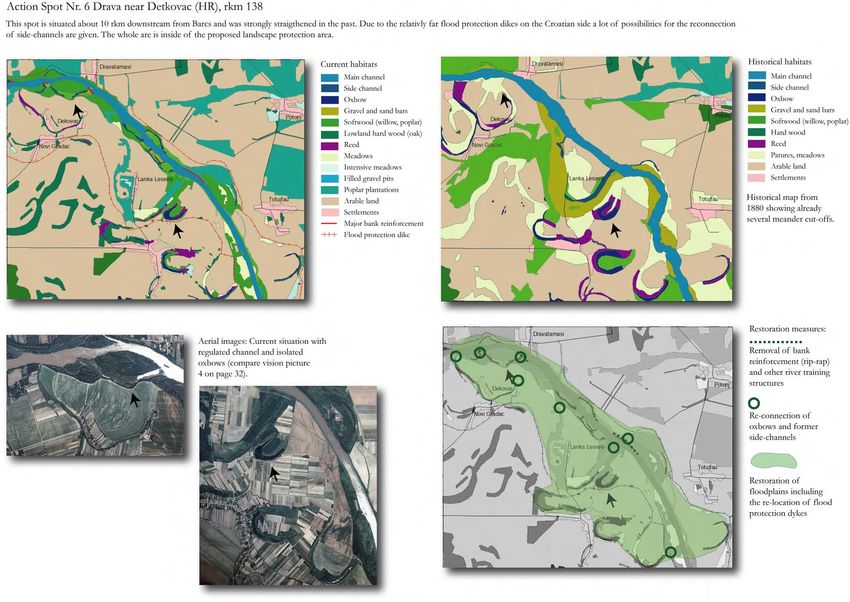
WWF Austria
Ottakringerstrasse 114-116
1160 Vienna, Austria
www.wwf.at

Konstanzer Str. 22
78315 Radolfzell, Germany
www.EuroNatur.org

Authors addresses:                  With contributions from:                               Cover photos:
Dr. Ulrich Schwarz                  Martin Schneider-Jacoby (EuroNatur),                   Drava River, children (Credit: A. Mohl/WWF), Sturgeon
Gärtnergasse 4/3                    Borut Stumberger (DOPPS-Birdlife Slovenia) and         (Credit: D.Kaltenegger/4nature), Little Tern (Credit:
A-1030 Wien                         Darko Grlica (Drava League)                            Roberto Sauli/www.ilsalesullacoda.it)
Email: Ulrich.Schwarz@FLUVIUS.com
Phone: 004369910591384
                                    In cooperation with:                                   Proofreading: Paul Chatterton, WWF Austria
DI Arno Mohl                        Drava League, Green Action, Croatian Society for the   Vienna, January 2009
WWF Austria                         Protection of Birds and Nature, Green Osijek, ZEO
Ottakringerstrasse 114-116          Nobilis, ZEUS, Drava Federation and DOPPS-Birdlife
A-1160 Vienna                       Slovenia
Email: arno.mohl@wwf.at
Phone: 004367683488300

Project website:
www.sterna-albifrons.net
                                                                                           This brochure was published with support of ASAMER
                                                                                           Holding (www.wwf.at/asamer)

                                                                                                                    Drava Vision 2020              1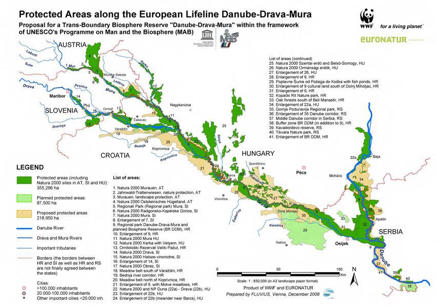
Executive summary                                      In order to better preserve the trans-boundary        through implementing a trans-boundary “River
                                                       ecosystem over the long term, innovative              Restoration Programme” (RRP) for the Lower
Spanning Austria, Croatia, Hungary, Serbia and         conservation and management efforts are needed.       Drava and Mura.
Slovenia, the lower courses of the Drava and
Mura Rivers are among Europe’s most                    An international NGO network – with members           This brochure attempts to provide the perspective
ecologically important riverine areas.                 including WWF, EuroNatur, Drava League,               for such a RRP by highlighting the restoration
                                                       Green Action, Croatian Society for the Protection     potential of eight selected areas along the rivers.
Once “protected” under the “Iron Curtain”              of Birds and Nature, Green Osijek, ZEO Nobilis,
during the Cold War, this trans-boundary river         ZEUS, Drava Federation and DOPPS-Birdlife             Passive management measures are proposed
system (including related sections of the Danube       Slovenia - has taken up this challenge and is         which will prevent further damage to the river
River) now forms a 600 km long “green belt”            working towards the establishment of a Trans-         landscape. Important steps in achieving this
connecting more than 400,000 ha of highly              Boundary UNESCO Biosphere Reserve “Danube-            include to ban further river regulation and
valuable natural and cultural landscapes.              Drava-Mura” (TBR “DDM”).                              sediment extraction activities as well as to prevent
                                                                                                             further impacts from hydropower dams.
The area is a hot spot of natural habitats that are    The protection of the area as a TBR is one of
rare in Europe such as large floodplain forests,       Europe’s most ambitious and exciting nature           Active restoration measures are recommended
river islands, gravel banks and oxbows. It is home     conservation projects, covering an overall area of    which include the removal of river training
to the highest density of White-tailed Eagles in the   more than 400,000 ha and spanning current and         structures in order to promote the self-restoration
Danube River Basin and hosts endangered species        future EU members. The plan for a TBR is              processes of the rivers.
such as little tern, otter and sturgeons.              already highly developed in Croatia and Hungary.
                                                                                                             River restoration and ecological river management
Moreover, the river ecosystem is the major source      Once established it will be Europe’s largest single   have the benefit of promoting and improving:
for quality water, for natural flood protection and    river protected area, providing a strong framework          • habitats and species populations
fisheries as well as an important area for             for protection and ecological management of the             • flood protection
recreation.                                            area’s unique natural values and forming a catalyst         • groundwater conditions
                                                       for sustainable development in the region.
                                                                                                                   • drinking water
Over 40 protected areas along the rivers underline
their ecological values. Most recently Croatia has     It would form a crucial part of the “European               • water quality
declared about 145,000 ha of the Danube, Drava         Green Belt” proposed by the World Conservation              • fish populations
and Mura area as a future Regional Park.               Union (IUCN), which aims to create an ecological            • sustainable forestry
                                                       network along the former Iron Curtain from the              • eco-tourism and recreation
However, the riverine landscape has seen many          Barents to the Black Sea.
changes and human impacts. Channelling of the                                                                River restoration and ecological river management
natural river courses, extraction of gravel and sand   The central management goal of a TBR should be        also are essential steps necessary for achieving
from the riverbed and hydropower dams are              to halt any further degradation of the riverine       compliance with the requirements of the EU
having a major impact on its ecological integrity,     landscape and to begin the improvement of the         Water Framework Directive, Flood Directive and
biodiversity values and natural resources.             natural river dynamics. This will be achieved         Habitats and Birds Directives.

                                                                                                                                     Drava Vision 2020          2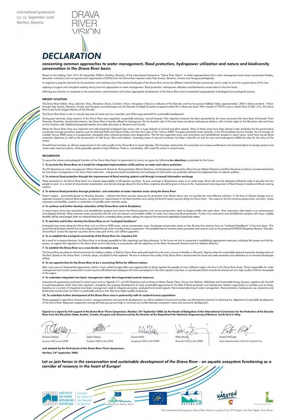
Vision                        international framework for the conservation and
                                                                management of the area.
The long term vision for the Lower Drava and                                                                          The Living Drava and
Mura Rivers is to have fully wild rivers over a large           This would span five countries, including current      Mura need space –
area and to secure their health and productivity for            and future EU members Austria, Croatia,                   For humans
all time. The aim is to ensure a variety of river               Hungary, Serbia and Slovenia.
dynamics, natural habitats and species while also                                                                          For nature
producing greater benefits in natural goods and                 Once established the TBR “DDM” would be:                     For life
services for local people.
                                                                 “Europe’s Largest River Protection Area” with
This should be achieved through the                             an overall size of more than 400,000 ha
establishment of trans-boundary protection and
ecological management of the riverine area as well               The World’s first Biosphere Reserve, that is
as the restoration of degraded river stretches and              commonly shared and managed across five
floodplain areas.                                               countries

                                                                 A backbone for regional cooperation,
                                                                international understanding and peace keeping
                                                                along the former “Iron Curtain”

Natural Drava River course in Croatia (Credit: B. Stumberger)

River restoration and ecological river management
would have multiple benefits including
biodiversity protection, natural flood protection,
water quality improvement, forestry and fisheries.
                                                                Living Drava – Space for children (Credit: Revital)
A Trans-Boundary UNESCO Biosphere Reserve
(TBR “DDM”) is proposed to provide the

                                                                                                                               Drava Vision 2020   3
Table of contents:

Executive summary … 2

Vision … 3

1. Drava and Mura Rivers: Ecological values,
international importance and protection status ... 5

     1.1 Ecological values         and   international
     importance ... 5
     1.2 Protection status ... 6

2. Historical state, pressures and impacts on the
Drava-Mura rivers ... 8

     2.1. Historical state ... 8
     2.2. Pressures and impacts ... 9

3. Future perspectives … 16

4. International examples of good river restoration
and ecological management ... 19

5. Action Plan … 20

     5.1. Action Spots with status, development and
     proposed restoration measures … 22
     5.2. Drava and Mura from above:
     The living Vision ... 32

6. Photo gallery nature and people … 33

7. References … 34

                                                         Drava Vision 2020   4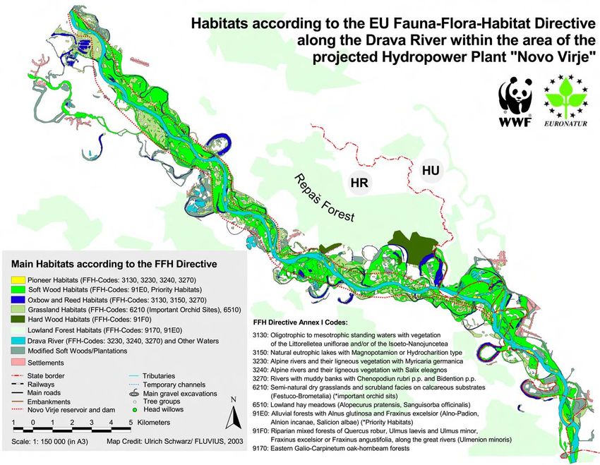
1. Drava and Mura Rivers: Ecological values,                   swampy softwood floodplain with shallow and very dynamic               The area hosts the best examples of rare natural habitats
international importance and protection status                 floodplain lakes (compare fig.40 in the chapter 3 "future              such as large softwood forests, wet meadows, natural
                                                               perspectives") (WWF 1999).                                             islands, gravel and sand banks, steep banks, side branches
1.1. Ecological values and international importance                                                                                   and oxbows.

The Drava has a length of 750 km and the Mura, its most                                                                               The hydrological dynamics of both rivers, its active erosion
important tributary, is 420 km long. These rivers spring in                                                                           and sedimentation, combined with periodic flooding of the
the Alpine mountains at 3,500 m a.s.l. with the Drava                                                                                 riverine areas of different duration, level and frequency,
joining the Danube on the edge of the Pannonian lowland at                                                                            have determined the formation of the landscape, their
80 m a.s.l.. Together the rivers drain an area of 48,000 km²                                                                          unique vegetation and rich biological diversity. Excellent
shared by Austria, Croatia, Hungary, Italy and Slovenia.                                                                              hydromorphological conditions can be found on shorter
With an average discharge of 550 m³/s at its mouth the                                                                                stretches along the Lower Mura, downstream of the Mura
Drava is one of the most important tributaries of the                                                                                 confluence in the Drava and along the Lower Drava
Danube.                                                                                                                               (Schwarz 2007, compare figure 4). In total over 60% of the
                                                                                                                                      Lower Drava and Mura falls at least into the "good"
                                                                                                                                      hydromorphological assessment class (for the upper
                                                                                                                                      catchment including Austria this good classification can be
                                                                                                                                      estimated for only some 20% of the river courses).
                                                               Fig. 2: More than 100 pairs of White-tailed Eagles breed along the
                                                               Danube-Drava-Mura river system (Credit: M. Romulic/
                                                               www.romulic.com).

                                                               The river system connects more than 400,000 ha of
                                                               landscapes with extremely high natural and cultural values
                                                               and an amazing biological diversity.

Fig. 1: The Drava-Mura basin (Credit: Schwarz/FLUVIUS).

The lower courses of the Drava and Mura Rivers, spanning
Austria, Croatia, Hungary, Serbia and Slovenia, are among
Europe’s most ecologically important riverine areas. They
                                                                                                                                      Fig. 4: Hydromorphological assessment of the Drava and Mura Rivers:
are extraordinary in having a 380 km long stretch that
                                                                                                                                      Blue and green colours indicate still highly valuable river stretches
remains free-flowing without any dams retaining the unity of                                                                          (Schwarz 2007).
an original riverine landscape. Adjacent stretches of the
middle Danube in excellent condition bring this figure to                                                                             The river system and its surrounding habitats host
almost 600 river kilometres. The well preserved alluvial                                                                              threatened plant and animal species of national, European
wetlands along the Danube in the trilateral area between                                                                              and Global importance. An estimated 5,000 different animal
Croatia, Hungary and Serbia include the famous Nature          Fig. 3: Natural stretch of the Mura along the border between Croatia   (including all insects) and over 600 different plant species
                                                               and Slovenia (Credit: A. Mohl/WWF).
Park “Kopački Rit”. This area covers about 23,000 ha of                                                                               alone in the Danube-Drava National Park in Hungary

                                                                                                                                                                        Drava Vision 2020                5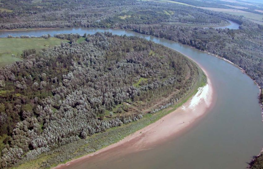
illustrates its great value for species protection and gene                                                                                        Drava region is one of the major areas for wintering birds in
pool preservation. For some species, the riverine landscape                                                                                        Europe with about 250,000 birds using the region during
constitutes one of their main or only habitats: for example                                                                                        their migrations.
more than 100 breeding pairs of the White-tailed Eagle
(Haliaaetus albicilla) live here - which make up to 40% of the                                                                                     The river system hosts more than 50 fish species amongst
population across the entire Danube basin population                                                                                               them the sturgeon. Endangered plant species include the
(compare fig. 5) (Schneider-Jacoby et al. 2003).                                                                                                   German Tamarisk (Myricaria germanica) which needs open
                                                                                                                                                   gravel and sand banks.

                                                                                                                                                                                                     Fig. 9: The
                                                                                                                                                                                                     Drava River
                                                                                                                                                                                                     is the only
                                                                         Fig. 7: Colonies of the Sand Martin and Bee-eater indicate intact river                                                     area for the
                                                                         dynamic along the Drava (Credit: WWF/EuroNatur).                                                                            German
                                                                                                                                                                                                     Tamarisk in
                                                                                                                                                                                                     Croatia
                                                                         The gravel and sand banks of the Drava River provide one                                                                    (Credit: U.
                                                                         of the last breeding grounds for the Little Tern (Sterna                                                                    Schwarz/
                                                                         albifrons) in inland Europe (Mohl 2001, Reeder et al. 2006).                                                                FLUVIUS).

Fig. 5: Distribution of the White-tailed Eagle within the Danube River                                                                             1.2 Protection Status
Basin. Note the concentration along the Danube-Drava-Mura river
system (Credit: WWF/EuroNatur).                                                                                                                    The ecological importance of the Drava-Mura and Danube
                                                                                                                                                   areas are reflected in the declaration of more than 40
The Drava with its natural river banks is one of the best                                                                                          protected areas on national level such as the Danube-Drava
breeding spots in the Danube basin for birds depending on                                                                                          National Park in Hungary, the Nature Park “Kopački Rit” in
these structures such as the Sand Martin (Riparia riparia) with                                                                                    Croatia and the Gornje Podunavlje Nature Reserve in
about 14.000 pairs (fig. 6 and 7), or for the Bee-eater (Merops                                                                                    Serbia. In February 2008 the Croatian Government has
apiaster) with about 2.000 pairs.                                                                                                                  given preliminary protection to the Drava and Mura and
                                                                                                                                                   related areas of the Danube as a Regional Park, covering
                                            Fig. 6: The Sand Martin,                                                                               145,000 ha of valuable natural and cultural landscape
                                            a typical inhabitant of                                                                                (compare fig. 42 in the chapter 3 "future perspectives").
                                            steep natural river banks    Fig. 8: One of the last river populations of the Little Tern in Europe
                                            (Credit: H. Kretschmer/      can be found on the gravel and sand banks along the Drava between         The natural values of the river system satisfy the criteria to
                                            4nature).                    Croatia and Hungary (Credit: S. Steiger).                                 be recognised and protected under international
                                                                                                                                                   conventions such as Ramsar, Bern and Bonn as well as EU
                                                                         Other species include the Common Tern (Sterna hirundo), the
                                                                         Common Sandpiper (Actitis hypoleucos) and the Little Ringed               environmental legislation, the Habitats and Birds Directives,
                                                                                                                                                   and as part of the European wide Natura 2000 network.
                                                                         Plover (Charadrius dubius). Furthermore, the Black Stork
                                                                                                                                                   Natura 2000 sites have already been established in Austria,
                                                                         (Ciconia nigra), the Ferruginous Duck (Aythia nyrocia) and the
                                                                                                                                                   Slovenia and Hungary and are planned in Croatia.
                                                                         Otter (Lutra lutra) find an important habitat in the area. The

                                                                                                                                                                                 Drava Vision 2020                  6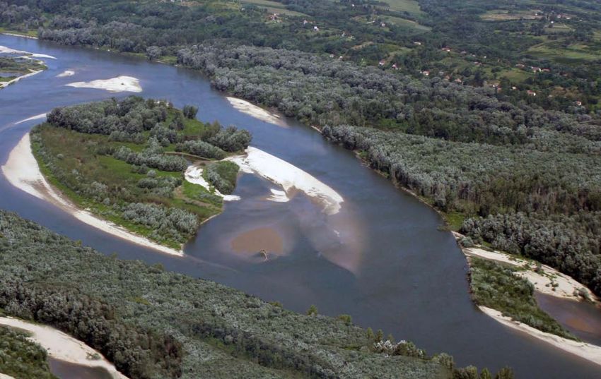
Fig. 10: Habitats according to Annex II of the EU Habitats Directive                                                                importance of the natural resources of the floodplain area
along the Drava between Botovo and Ferdinandovac (Credit:                                                                           for the socio-economic well being of this region. The
WWF/EuroNatur 2005).                                                                                                                natural resources in the area help to minimise expenditure
                                                                                                                                    e.g. on water purification and supply, irrigation and flood
                                                                                                                                    prevention systems. Natura 2000 on the Border Mura also
                                                                                                                                    attracts public funding for the region and has middle- to
                                                                                                                                    long-term positive economic benefits for quality tourism
                                                                                                                                    and agriculture (WWF 2002a).

                                                                                                                                                                             Fig. 11: River mill:
                                                                                                                                                                             Economic benefits
                                                                                                                                                                             from sustainable
                                                                                                                                                                             tourism along the Mura
                                                                                                                                                                             (Credit: Ecology in
                                                                                                                                                                             progress)

                                                                                                                                    The monetary value of the riverine landscape can also be
                                                                                                                                    considerable. According to a calculation of the Faculty of
                                                                                                                                    Forestry in Zagreb, the value of the Koprivnica-Đurđevac
                                                                                                                                    lowland forests, including the important Repaš forest
                                                                                                                                    (4,000 ha of typical Slavonian oak lowland forest) which is
                                                                                                                                    directly depending on the riverine dynamic groundwater of
                                                                                                                                    the Drava in Croatia, is about € 900 Million. It includes the
                                                                                                                                    beneficial functions of the river and the raw material and
                                                                                                                                    energetic function (without subsidiary forest products such
                                                                                                                                    as hunting, fruits, mushrooms, medicinal herbs and others).
                                                                                                                                    Other forest functions (carbon dioxide absorption, water
                                                                                                                                    and air cleaning, the positive influence of forests on climate,
                                                                                                                                    have not been included in this calculation (Pripić 2001).

                                                                                                                                                                              Fig. 12: The natural
                                                                                                                                                                              Drava River provides
                                                                                                                                                                              space for fun and
Within a 30 km long river stretch of the Drava downstream              Beside biodiversity conservation the riverine system also                                              recreation (Credit: A.
of the Mura confluence over 50 main types and                          offers multiple benefits including flood protection, water                                             Mohl/WWF)
combinations of habitats (EUNIS classification) have been              purification, nutrient reduction, groundwater recharge and
described. This diversity is as high as many national parks in         drinking water supply, sustainable forestry, fisheries,
the area and is comparable with the Bulgarian Danube                   recreation and ecotourism (Schneider-Jacoby 2002).
Islands on the Lower Danube.                                           An assessment study on the effects of Natura 2000 on the
                                                                       Mura between Austria and Slovenia has shown the high

                                                                                                                                                                   Drava Vision 2020               7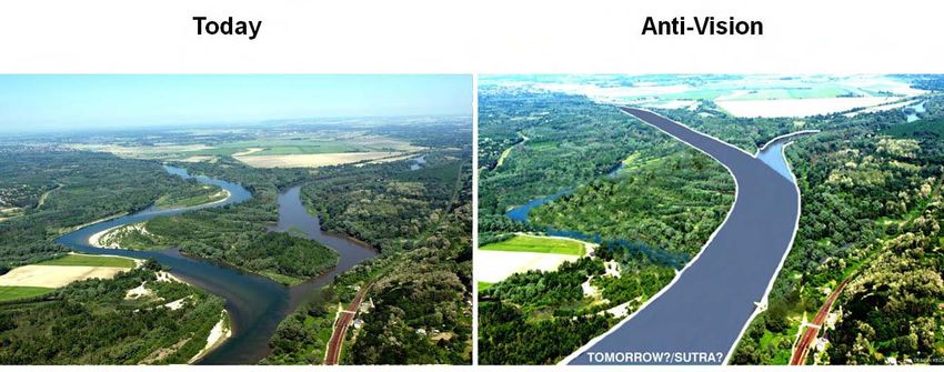
2. Historical state, pressures and impacts on the
Drava-Mura Rivers
2.1. Historical state

Up to the end of the 18th century, the Lower Drava and
Mura Rivers were free flowing wild rivers. Maps, pictures
and travel reports from that time show a dynamic river
landscape. The rivers were characterized by braided and
meandering river reaches with extended riverine habitats
such as gravel and sand banks, steep banks, oxbows,
woodlands, pastures and meadows (see fig. 3 and 14).

This natural river system was fairly wide, not too deep, and
characterised by unstable banks. Large-scale floods occurred
at regular intervals. The location and shape of gravel and
sand banks, islands and river branches used to change
continuously. The rivers would regulate themselves through
this state of dynamic balance.
The only significant changes came from landuse in the
catchment, through deforestation in upper catchments
which increased the sediment load. Also the usage of
floodplain areas as source for wood and fish or as pastures
led to a reduction of riparian forests.

                                                                                                                                Fig. 15: The first map shows the braided river type near Varazdin, the
                                                                                                                                second map shows the transition towards the meandering type
                                                                                                                                downstream of the Mura confluence and the third map shows the
                                                                                                                                already altered lower meandering river reach (all maps are from
                                                                                                                                Austrian 3rd Landesaufnahme 1879-1902 1:75,000).

                                                                                                                                The analysis of morphological "reference conditions" such
                                                                                                                                as the width-depth variability, the sinuosity (degree of
                                                                                                                                meandering), substrate and habitat distribution should be
                                                                                                                                based on historical data (in particularly maps), but also
Fig. 13: River stretch at Varaždin with high hydromorphologcial                                                                 species lists and comparative studies with still intact river
dynamic and floodplain forests, building several side channels and
large pioneer habitats on gravel banks, CORONA satellite data 1968                                                              systems (compare Schwarz 2007). Those reference
(Credit: WWF)                                                                                                                   conditions are important for the proposal of restoration
                                                                     Fig. 14: Time series of a Drava River course at Jeskovo/   sites.
                                                                     Croatia 1879, 1965, 1992) (Credit: WWF/EuroNatur)

                                                                                                                                                                  Drava Vision 2020                 8
2.2. Pressures and impacts                                        The typical sequence of meanders with point bars and steep             Gravel and sand banks as well natural steep river banks
                                                                  banks (compare cover picture in right lower corner)                    which one the most important dynamic river habitats, have
The ecological values of the free-flowing Lower Drava and         disappeared over most of the reach and the degradation of              been reduced to a large extend (see fig. 18 and 19).
Mura Rivers in Croatia, Hungary and Slovenia are faced with       the sandy river bed increased due to the concentration and
considerable degradation, which results from various types        the higher velocity of the flow in the straightened channel.
                                                                                                                                           1600
of anthropogenic activities: river bed regulation, excessive                                                                                               1400 ha
gravel and sand extraction from the river bed, construction                                                                                1400

of flood protection dykes and hydropower dams in the                                                                                       1200
upstream sections.
                                                                                                                                           1000

Though river bed degradation and river bed deepening                                                                                        800

along the free-flowing stretches has its origin in all types of                                                                             600
activities, past and ongoing river regulation and sediment                                                                                  400
extraction activities has considerably multiplied and
                                                                                                                                            200                                                     110 ha
accelerated the impacts of the hydropower dams which are
situated in the upstream sections (compare Biondic 1999).                                                                                     0
                                                                                                                                                             1879                                   1997
                                                                  Fig. 16: Significant shortening of the Lower Drava since 1830 (after
                                                                                                                                                                     Gr avel and sand banks/bar s
River regulation                                                  Bognar 1990).
As similar to almost all northern and eastern Alpine rivers                                                                              Fig. 18: Reduction of sand banks/bars in ha along the Drava (Botovo-
the Lower Drava and Mura were subject of different river          In the 20 th century the river bed degradation has increased
                                                                                                                                         Ferdinandovac) in the last 100 years (Credit: Mohl/Schwarz 1998).
regulation epochs and hydropower dam construction                 considerably along the entire lower course of the Drava due
periods. In particularly the so called high and mean water        to past impacts of regulation works and continued
regulation in the 19 th and 20th centuries can be mentioned as    straightening of the rivers and the fixing of the natural                  90

the most significant impact on the river system.                  banks with stones (bank reinforcement with rip-rap).                       80
                                                                                                                                                                                                79%

The very early regulation works in the 17th century were                                                                                     70

mostly aimed for local flood protection by the building of                                                                                   60
small flood protection dikes close to settlements. Dike
                                                                                                                                             50
construction for protection of arable land and settlements
started systematically in the second half of the 20th century.                                                                               40

In this way about 70% of the former morphological                                                                                            30
                                                                                                                                                            21%
floodplain within the natural lower terraces has been                                                                                        20

disconnected from the river and natural flooding regime.                                                                                     10
Whereas high water regulation has reduced the natural                                                                                         0
inundation areas, mean water regulation has considerably                                                                                           Natural s teep banks             A rtificial s teep banks
altered the natural river courses.                                                                                                                                                        (reinfo rced)
In the 18 th and 19th century the mean water regulation (in
particularly by cutting meander reaches) along the Lower
                                                                                                                                         Fig. 19: Reduction of natural steep banks in % along the Drava and
Drava was mostly forced by the waterway transport (K&K                                                                                   Mura (selected banks, Murska Središće-Osijek 2005) (Credit:
Donaudampfschifffahrtsgesellschaft) but also by the                                                                                      WWF/EuroNatur)
drainage of agricultural land. Between 1784 to 1848 62
                                                                  Fig. 17: River bed degradation on the Drava in Croatia between
curves were cut and the river downstream of Barcs was             Botovo and Ferdinandovac in the last 120 years (Credit: Hrvatska
shortened by about 40% of its natural length (see figure 17).     Elektroprivreda 2000).

                                                                                                                                                                                Drava Vision 2020              9
In the second half of the 20th century, the Lower Drava and
Mura Rivers along the Croatian-Hungarian border were well
preserved for more than 40 years as part of the former
“Iron Curtain”. Only minor river regulation activities have
taken place. However, after the political changes in the
beginning of the nineteen nineties last century Croatia and
Hungary has resumed the regulation of natural river
stretches and the reinforcement of river banks in
ecologically sensitive areas.
These activities last until today and the old principles of the
Croatian-Hungarian water management strategy for the
Drava from the 1980ties are still applied along the entire
river. Its main aim is to create and maintain a uniform
canalised river corridor free of side arms, gravel and sand Fig. 22: Status and "Anti-Vision" in case of confluence rectification
banks and river islands with following width:
As a consequence many natural river stretches along the
110 m width from Varaždin to Legrad Lower Drava such as between Legrad and Barcs have been
160 m width from Legrad to Barcs destroyed. Valuable breeding areas for endangered bird
170 m width from Barcs to Dravaszabolcs species such as the Little Tern, Common Tern and Sand
180 m width from Dravaszabolcs to Osijek Martin have been lost or reduced significantly.
220 m width downstream Osijek
In 2008 a massive river regulation plan was issued by the
Croatian Ministry responsible for Water Management
aiming at regulating 56 km natural Drava river course at
Osijek. This stretch had in fact experienced a unique self-
restoration process in the last 100 years (see fig. 47 in
chapter 5).
Fig. 23: Destruction of a natural river bank with a colony of Sand
Martin at Sigetec/Croatia in 2007(Credit: A. Mohl/WWF)
Fig. 21: In detail: Planned regulation of the natural confluence of the
Mura into the Drava within the Special Zoological Reserve „Veliki
Fig. 20: Planned regulation of the natural riverbed of the Drava with a Pažut“ and the preliminary declared Croatian Regional Park “Drava-
width of 160 m at the Mura confluence (Credit: Schneider-Jacoby 2005). Mura”; blue line = regulation line (Credit: Croatian Waters 2008)
Drava Vision 2020 10development (even the first two classes require regular completely changed into a series of five barrages and
maintenance, in particularly dredging). With a lack of abstraction canals.
industrial areas along the Drava the usage for navigation is
strongly limited and questionable in particular upstream of
Osijek.
In most cases the regulation works are being done without
any appropriate environmental impact assessment. The
studies are poor and are not meeting EU standards.
River regulation as well as sediment extraction along the
free-flowing stretches in Croatia and Hungary has
accelerated the river bed degradation and the deepening
process and thus has considerably multiplied the impacts of
hydropower dams.
Fig. 26: Drava near Prelog before (1968) and after the construction
(1989) of the hydropower dam “Donja Dubrava” (Credit: WWF).
Hydropower dam construction
A chain of 50 hydropower dams - 22 on the Drava and 28
on the Mura - has been established along the upper and
middle courses of the Drava and Mura Rivers (see fig. 1 and
25-27) in Austria, Croatia and Slovenia.
Place Power house Year Reservoir area
removing natural
river landscape
Maribor Zlatolice (SI) 1969 < 1 km²
Ptuj Formin (SI) 1981 4,2 km²
Ormož Varaždin (SI/ HR) 1975 3,0 km²
Varaždin Čakovec (HR) 1982 10,5 km²
Fig. 24: River regulation on the Drava at Repaš/Croatia in 2003 Dubrava Dubrava (HR) 1989 16 km²
(Credit: A. Mohl/WWF)
Fig. 25: The hydropower dams in Slovenia and Croatia downstream Fig. 27: Typical situation of a diversion dam system on the Drava at
The enhancement of navigation along this stretch with from Maribor (Credit: WWF/EuroNatur) Varaždin: The Dam reservoir covering the whole former riverine
channel stabilisation and dredging measures endangers the landscape; bypass canal to the power house (energy production) on
richness of this intact lowland river ecosystem. Officially the Concrete plans for dams along the still free flowing lower the right side and release channel for flood situations on left side
Drava is navigable up to about rkm 180 near Ferdinandovac courses of the rivers in Slovenia, Croatia and Hungary have (Credit: WWF)
including all core zones of the Hungarian National Park existed since the 1960s. The last dam to date on the Drava
River was finalised by former Yugoslavia in 1989, at Donja The political changes in 1989, after the fall of the “Iron
which is also a Natura 2000 site. The river should be usable Curtain”, influenced the decision between former
for ECE class I, II. Only the lower part from Osijek to Dubrava, a few kilometres above the confluence of the
Mura into the Drava close to the border to Hungary. The Yugoslavia and Hungary to build further dams on the Drava
Belišće falls into class III and from Osijek to the Danube in along their border section. The new government in Hungary
class IV. All those classes require specific depths, width and natural river course and its braided section have been
decided to preserve the river and the natural resources as
minimum radius which contradict the natural river course
Drava Vision 2020 11drinking water reserve and natural areas. Although the law The free flowing river stretch of the Drava downstream of has been affected. The 4000 ha large Repaš forest with
to create the Danube-Drava National Park passed the last dam at Donja Dubrava in Croatia is suffering severe Penincula oak, is highly impacted due to changed natural
Hungarian parliament in 1991 and the Park was established river bed erosion due to a much reduced load of sediments. river bed and groundwater conditions (see chapter
in 1996, Croatia, as the successor of Yugoslavia, continued The total amount of sediment transport has decreased “ecological values”).
to propose to build further dams, in particular the largest significantly since 1975 by about 50%. The bed incision
dam at Novo Virje. A trans-boundary environment impact related to the low water stage is up to 3,5 cm/year. The In addition to the bed-load deficit, the hydrological and
assessment under the ESPOO Convention was conducted groundwater table lowering within 120 years is up to 370 cm flooding regime along the Lower Drava between Croatia
of this dam in 2000. The Hungarian government opposed (Hrvatska Elektroprivreda 2000). and Hungary has changed. In particular the amplitude and
the Novo Virje project. Finally in 2007 the Croatian frequency of small flood events (1-5 year annual flood)
Government decided against the dam project. The channel incision mainly leads to the degradation of the decreased (evaluation of discharge data from 1970-2000).
natural river bed (unification of river course and loss of The water retention in the reservoirs upstream on the Drava
The last dam on the Mura was built at Spielfeld in Austria valuable habitats as gravel and sand banks, side arms) and to River reduces the discharge peaks (high – with the exception
close to the border to Slovenia in the 1980s. However, in the lowering of adjacent groundwater tables with the of catastrophic floods - and low water situation). The last
2006 the Slovenian government has resumed earlier plans degradation of floodplain areas (drying out of floodplain two Slovenian and the last three large Croatian power plants
and has proposed further dams on Natura 2000 list areas of habitats such as forests, meadows and oxbows and loss of work in peak energy mode (see fig. 25). As a consequence
the Mura River including the border section with Austria. typical riparian species, raising floodplain levels due to fine the water level on the Lower Drava changes sometimes
sedimentation during floods). This in turn affects terrestrial several times a day by between 0,6 –1,8 m. Also the
Today the impacts of the existing chain of hydropower vegetation structures and species compositions. unregulated discharge of Mura and flow retention in side
dams on the Drava and Mura in Austria, Croatia and channels downstream of the Mura confluence cannot greatly
Slovenia on the free flowing lower stretches of both rivers reduce the level fluctuations (compare also 14). The daily
are everywhere evident with regards to changes in hydrology water oscillation by hydropeaking is evident more than 200
(hydropeaking, altered discharge regime) and morphology km downstream (Barcs up to 80 cm, few cm in Osijek close
(river bed degradation and channel incision). to the Drava mouth). In general the most natural parts of
this stretch buffer the ecological impact due to reduced and
retarded increase and decrease of water levels.
Fig. 29: Changed groundwater conditions in the 4,000 ha large lowland
Repaš forest in Croatia between Botovo and Ferdinandovac in the last
100 years strongly correlates with river bed degradation of the Drava
between Botovo and Ferdinandovac, stretching from blue and brown
colour scale: from 0 m and less (surface water) in blue and dark brown
to 3 m and more (out of the rooting zone) in light brown and orange
(Credit: Hrvatska Elektroprivreda 2000).
Fig. 28: The progression of new water level markers shows local river Fig. 30: Daily water level fluctuations in the Drava downstream of the
bed incision rates (Credit: B. Stumberger, Hrvatska Elektroprivreda Furthermore, the economic value of important lowland Dubrava dam (Botovo gauge, 15 km downstream of Mura confluence)
2000). forest areas along the Drava River in the Podravina region (Credit: Croatian Waters).
Drava Vision 2020 12As a consequence of the peak power mode (pulse releases)
fish populations along the Drava have declined
considerably.
Fig. 31: Bélavár side arm during “low water peak” showing a clogging
of the gravel by fine sediments due to the daily water oscillation
(Credit: A. Mohl/WWF)
Further the residual water in the diverted stretch (“Stara
Drava” in Slovenia and Croatia) is mostly insufficient and in
particularly gravel excavation leads to a substantial
degradation of this former rivers courses (compare fig. 38). Fig. 32: The total amount of extracted material from the Drava during
1982-2002 is more than 9 million tons, which is equal to about
450,000 t/yr. The average annual bedload transport is only about
Sand and gravel excavation 100,000 t for the corresponding river stretch (Rákóczi 2008).
The Drava and Mura alpine and sub-alpine valleys hold an Extraction along the Croatian-Hungarian border stretch of
enormous quantity of Holocene sediments. Gravel and sand the Drava between Vizvar and Barcs has caused more than
layers reaches a thickness of more than 150 m. The 90% of the riverbed deepening between 1970 and 2000
commercial large-scale sand and gravel excavation along the (compare chapter “river regulation” and “hydropower
Lower Drava and Mura Rivers in Croatia and Hungary in dams”). Furthermore, extraction leads to a loss of valuable
conjunction with the maintenance of the regulated river dynamic habitats as gravel and sand banks, hosting several
channel for flood protection and navigation has been red list species and international endangered species of the
focused on the recent floodplain and the main channel. FFH annexes such as Little Tern or Stone Curlew.
For over 30 years sediment extraction from the river bed Fig. 33: Public tender in 2005 for extraction for 2,000,000 m³ gravel
has been taking place in various areas along the rivers in and sand from the Drava River (Ministry for Agriculture, Forestry and
Hungary and Croatia and new plans for further massive Water Management Croatia)
extraction have been developed especially in Croatia in
recent years. The impacts on the natural river bed are
considerable.
Drava Vision 2020 13The list of continuous dredging is long and licenses have hydropower dams (compare chapter “river regulation” and
been given even within the Danube-Drava National Park “hydropower dams”).
and Natura 2000 site.
Fig. 34: Gravel extraction on the Drava at Botovo/Croatia in 2006
(Credit: A. Mohl/WWF)
Fig. 37: Sediment extraction sites along the Drava in Hungary within
the Danube-Drava National Park and the Natura 2000 site (Credit:
South-Danubian Water Authority 2005) Fig. 38: Intensive gravel excavation and destruction of the former
Drava river bed near Varaždin (Credit: ZEUS)
Beside ongoing extraction on various spots along the rivers
huge sediment extraction plans have been developed and
partly implemented in Croatia in recent years:
2003: The old Drava river bed between Varaždin and
Fig. 35: Sand extraction along the Lower Drava in 2004 (Credit: A. Ormož was partly destroyed by systematic excavation to win
Mohl/WWF)
and sell gravel for the construction of a highway (see fig.
38).
2005: A plan to extract 2, 000, 000 m³ on 20 sites along the
entire Lower Drava was issued by the Croatian Ministry
responsible for Water Management (see fig. 33 and 40).
2007: A further plan to extract 800,000 m³ along the 60 km
Drava River stretch at Osijek was issued by the Croatian
Ministry responsible for Water Management.
Fig. 39: 2,000,000 m³ planned 2005-2009 (Croatia) equals a 870 km
long train from Zagreb via Beć to München (Credit: WWF)
Sediment extraction as well as river regulation along the
free-flowing stretches in Croatia and Hungary has
Fig. 40 (next page): Water management impacts along the Lower
accelerated the river bed degradation and the deepening Drava and Mura Rivers (Credit: WWF)
Fig. 36: Sand extraction along the Lower Drava at Osijek/Croatia in process and has considerably multiplied the impacts of
2008 (Credit: D. Grlica)
Drava Vision 2020 14Drava Vision 2020 15
3. Future perspectives                                             status for the region and a framework that could combine         means to ensure that a TBR is truly operational. However, it
                                                                   together the cluster of different protected areas would          should be kept in mind that, although the biosphere reserve
An International River Restoration Programme for the               encourage trans-frontier cooperation for the protection and      provides a general framework for action in a trans-boundary
Drava and Mura Rivers                                              sustainable management of the area.                              location, the real-world situations will vary very much from
                                                                                                                                    one place to another, and flexibility is needed even more
The ongoing degradation of the natural courses of the              The overall goal would be: a large Trans-Boundary                than in a national context.
Drava and Mura Rivers is the major threat for the                  UNESCO Biosphere Reserve along the Danube, Drava and
biodiversity values and natural resources of the region            Mura, spanning Austria, Croatia, Hungary, Serbia and             The process leading towards the official designation of a
(Schneider-Jacoby 1998).                                           Slovenia (see fig. 42) and covering at least 400,000 ha          TBR can include many forms of co-operation and co-
                                                                   (EuroNatur 1999, WWF 2006).                                      ordination among the existing areas on either side of a
In order to halt and ideally reverse this process a joint trans-                                                                    border. These serve as a basis for formalising the TBR
boundary “River Restoration Programme” (hereafter RRP) for         This goal including the creation of many new protected           proposal and should be encouraged
the Lower Drava and Mura is proposed to be implemented             areas along the rivers. Most recently, the Croatian Ministry
between all countries involved.                                    of Culture has preliminary designated about 145,000 ha           Procedure for the establishment of a TBR
                                                                   along the Danube, Drava and Mura in Croatia as a Regional        Up until now, all existing TBR were established as separate
Within such a RRP special focus should be given to the key         Park. The plan for a TBR including the delineation of core       biosphere reserves in individual countries before being
problems caused by river regulation, excessive gravel and          and buffer zones is already highly developed in Croatia and      designated as TBR. However, it could be envisaged in the
sand extraction from the river bed and the hydro-peaking           Hungary.                                                         future that a TBR would be established jointly by the
mode of the last Croatian hydropower plant.                                                                                         countries concerned in one step. In both cases, the ultimate
                                                                   Trans-Boundary Biosphere Reserves (comp.                         aim should be to have one functional biosphere reserve.
The common RRP should be developed and implemented                 www.unesco.org/mab)
by the competent Water Management and Nature                       As borders between states are political and not ecological,      In these two different scenarios, the following respective
Protection Authorities of the countries in cooperation with        ecosystems often occur across national boundaries, and may       procedures are recommended:
international institutions (e.g. EC, ICPDR) and experts.           be subject to different, or even conflicting, management and        • Establishment of a biosphere reserve on each side of
                                                                   land use practices. Trans-boundary Biosphere Reserves                  the border;
A RRP will support the effective common implementation             (TBR) provide a tool for developing common management               • or, when the TBR is established in one step,
of EU environmental law, the Water Framework Directive,            and protection.                                                        definition of the zoning of the area according to the
the Floods Directive and the Habitats and Birds Directives                                                                                general criteria for designation of biosphere reserves.
in the region.                                                     A TBR is important in providing official recognition at an          • Identification of local and national partners and
                                                                   international level and by a UN institution of the political           establishment of a working group to define the basis
A Trans-Boundary UNESCO Biosphere Reserve “Danube-                 will to co-operate in conservation and sustainable use                 and identify key issues for co-operation.
Drava-Mura” (hereafter TBR “DDM”) would create an                  through common management of a shared ecosystem. It
                                                                                                                                       • Signing of an official agreement between
appropriate international framework for the cooperation in         also represents a commitment of two or more countries to
                                                                                                                                          governmental authorities regarding the TBR.
the development and implementation of the RRP.                     apply together the Seville Strategy for biosphere reserves
                                                                   and its objectives. And it reflects the increasing recognition      • Nomination of the various parts by the respective
Trans-Boundary  UNESCO                 Biosphere      Reserve      of the appropriateness of the ecosystem approach, for                  State authorities;
“Danube-Drava-Mura”                                                conservation and sustainable use of biological diversity.           • or, when the TBR is established in one step, joint
                                                                                                                                          nomination for the whole area by the concerned State
During the first EuroNatur Conference in Kaposvar in               The recommendations presented below deal with the                      authorities.
1993, the idea of a Trans-Boundary Biosphere Reserve for           establishment of TBR, the measures which can be taken to            • In both scenarios, indication of the main components
the entire riverine landscape was born (Schneider-Jacoby           respond to the Man and the Biosphere (MAB) principles                  of a plan for co-operation in the future.
1996). It was clear that only an internationally recognised        and in particular the goals of the Seville Strategy and the         • Official designation by ICC MAB of UNESCO.

                                                                                                                                                                 Drava Vision 2020            16
Functioning of the TBR Among the measures represented in the structure.
recommended to make the TBR function effectively, • This structure has a permanent secretariat, and a
priority should be given to: budget is devoted to its functioning.
• Preparation and adoption of a zonation plan for the • A person is designated on each side to act as a focal
whole area and implementation of the zonation by point for co-operation.
strict protection of core areas, delimitation of the • General and regular meetings of the co-ordinating
buffer zones and co-ordinated objectives for the structure are complemented by thematic groups, on
transition areas; this implies that the countries an ad hoc basis, in order to create a platform for
concerned have a common understanding of the discussion among stakeholders from the countries
characteristics of each of the zones, and that similar concerned, with a view to promote all opportunities
management measures are in place for each zone. for exchanging views and knowledge.
• When the zonation plan is defined, publication on a • Joint staff teams are operational for specific tasks.
joint map of the zonation.
• Definition of common objectives and measures, An association is set up with the specific aim of promoting
work plan, time table, and required budget; this the TBR.
should be a demand driven process, based on
perceived needs or management requirements. This
work plan should take into account the elements
listed under the goals of the Seville Strategy as
suggested below.
• Identification of potential funding sources for the
work plan and joint or simultaneous application for
these funds.
• Establishment of a means of communication
between the co-ordinators/managers of the different
parts of the TBR, including electronic mail when
feasible.
• Efforts towards harmonised management structures
Fig. 41: Zoning concept of a Biosphere Reserve (Credit: UNESCO
on each side.
M aB)
Institutional mechanisms The TBR will not function
without a joint structure devoted to its co-ordination.
Although this structure can vary greatly from one TBR to
another, the following points can be recommended:
• The co-ordinating structure is representative of
various administrations and the scientific boards, as
well as the authorities in charge of the protected
areas, the representatives of local communities,
interested and affected groups, including youth, and
of the private sector. Fig. 42 (next page): Protected areas along the Danube, Drava and
• The NGO sector in the region should be also Mura Rivers and proposed Trans-Boundary UNESCO Biosphere
Reserve
Drava Vision 2020 17Drava Vision 2020 18
4. International examples of good river
                                                                                                                                        International examples of good river restoration and ecological river
restoration and ecological river management                                                                                             management
                                                                                                                                        To date there have been six finalised or ongoing large river restoration projects
                                                                                                                                        along the Drava and Mu ra Rivers. They have been mainly aimed at restoring the
Benefits for nature conservation and water                                                                                              river dynamics by w idening of the river bed and reconnection of the former side-
management                                                                                                                              arm system. Benefits encompass stopping of river bed deepening and improving
Today, problems in river ecosystems for both nature                                                                                     natural flood protection and maintaining and restoring characteristic habitats and
                                                                                                                                        species populations. Around 20 Million Euros have been allocated in total incl. the
conservation and water management have basically the same                                                                               support of the EU funds for w ork related to river restoration. Tw o projects have
origin: a high degree of river engineering of natural water                                                                             been funded under Interreg IIa and IIIa (border Mura betw een Austria and
                                                                                                                                        Slovenia), the others under LIFE Nature (upper Mura and Drava I + II in Austria,
courses. The enormous decline of freshwater biodiversity                                                                                inner Mura in Slovenia) (Mohl 2004).
has challenged nature conservationists, whereas the                                                                                     These projects have been carried out in partnership w ith w ater management and
deterioration of natural flood retention capacity, the river                                                                            nature conservation bodies as w ell as other institutions and organisations such as
                                                                                                                                        NGOs. WWF Austria has supported several of them, either as a project partner such
bed deepening and the fall of groundwater tables has caused       Fig. 43 and 44: Preserved and well managed dynamic natural river      as for the Life project in Slovenia or as a facilitator in the project development. More
a paradigm shift in the Water Management Authorities. For         course of the Allier by an active land management (Credit: LN-CEPA-   information on the ongoing Life project in Slovenia available under: www .biomura.si
the sake of both, conservation of valuable habitats and           JS)
species and sustainable water management, numerous river                                                                                Elbe (Germany)
                                                                  Upper Drava (Austria)
restoration projects were or are already implemented on
several rivers in Europe. Good examples with the aim of                                                                                 Key measure: Active removal of the dike system and creation of
                                                                  Key measure: Active River bed widening and re-connection and          natural retention areas
maintaining and restoring the natural river dynamic               creation of side arms
processes can be found on the rivers Drava in Austria,                                                                                  Info:www.biosphaerenreservatmittlereelbe.de/contenido_468/cms/in
Loire/Allier in France or Elbe in Germany.                        Info: www.life-drau.at                                                dex.html

Loire/Allier (France)

Key measure: Land owner management to maintain and improve free
river dynamics especially lateral erosion

Info: www.rivernet.org/loire/lifeloire/life_e.htm

                                                                                                                                        Fig. 46: Enlargement of the active floodplain on the Elbe (Credit:
                                                                  Fig. 45: Drava River before and after restoration (Credit: Water      LHW Sachsen-Anhalt, 2006)
                                                                  Management Authority of Carinthia/Tichy)

                                                                                                                                                                                  Drava Vision 2020                         19
5. Action Plan
The Strategy and Action Plan provides the basis for a
future RRP.
Objectives and Strategy:
A common approach to obtaining a valuable and
ecologically functional Drava River has already been
discussed between all Drava Basin countries on the
International Symposium “Drava River Vision“, which took
place in Maribor in September 2008 (BM LFUW et al. 2008).
The Symposium was attended by representatives from water
management and nature conservation bodies, educational
institutions and non-government organizations (NGOs)
from the Drava River riparian states - Austria, Croatia,
Hungary, Italy and Slovenia - as well as from international
institutions such as the European Commission, UNESCO
and the International Commission for the Protection of the
Danube River (ICPDR).
A joint Declaration, including ten key objectives, has been
endorsed by representatives of the water management sector
of all five Drava Basin countries and supported by the
participants. This joint statement will support the future
cooperation in the conservation and ecological management
of the river and will help the countries to meet the
challenging environmental objectives of the EU.
Drava Vision 2020 20Restoration measures River restoration projects need to be developed and
implemented for impacted river sections and funded e.g.
Based on the international Drava Declaration and its through EU programmes.
objectives (see above) key measures can be defined for the
Lower Drava and Mura Rivers which would lead to Major river restoration measures shall include:
ecological and sustainable river management. These
measures should be included in the proposed RRP. • Removal of bank reinforcement (rip-rap) and other river
training structures
Initial management measures, particularly in Croatia and • Re-connection of oxbows and former side channels
Hungary should prevent further damage to the river • Restoration of floodplains including the re-location of
landscape:
flood protection dykes
• Restoration of tributaries
• Any further extraction of sediments from the riverbed
and banks and therefore from the river system should be
prevented. Example: Self-restoration of the Drava river bed
• Free river dynamics (bank erosion, channel changes) of
As sediment management of the Lower Drava and Mura is a
the Lower Drava and Mura should be allowed where no
key issue to stop the further river bed degradation, river
infrastructure is endangered. Instead of further river
restoration measures should always make use of the self-
training structures, alternative measures of river restoration capacity of the rivers and should promote the re-
management should be applied (e.g. compensation of
mobilisation of sediments from lateral erosion.
land owners, removal of dikes).
• In case further river training structures have to be A very good example for self-restoration due to lateral
established to protect infrastructure (bridges, roads, erosion is the Drava River in Croatia upstream of Osijek.
dykes) or settlements and if this cannot be achieved by
other means, ecological compensation measures should The trend of bed degradation has been reduced
be implemented in other sections of the river in order to considerably, after a 90 years long “self-restoration” process
recognise the changed management approach from and re-meandering. This Drava stretch was completely
“river regulation” to “ecological river management and straightened 100 years before (flood protection, navigation)
river restoration”. by the Austrian K&K monarchy. As the river was not
• New hydropower dams along the rivers should be strongly impacted by hydro-engineering measures since
banned e.g. the planned dams on the Mura in Slovenia or World War I, the Drava has started to re-meander again
further dams on the Drava in Croatia. (compare fig. 47). This part of the Drava could serve as a Fig. 47: Time series of river course development upstream of Osijek
• The operation of the last hydropower dam on the Drava good reference for sustainable river management and for (1885: complete straightening for navigation purposes under the K&K
at Donja Dubrava in Croatia should be adapted to the individual restoration measures. monarchy; 1910: abandoned maintaining measures allow re-
ecological needs of the free-flowing 230 km long meandering; 1997: further re-meandering of the river course) (WWF
downstream section, in particular by stopping hydro- 2002b).
peaking and restoring the natural river flow.
• The creation and improvement of the Lower Drava in
particular the entire river stretch upstream Osijek as an
inland water way should be abandoned.
Drava Vision 2020 21• The general hydromorphological situation (mostly
along altered river stretches)
What was evaluated for each spot?
The following parameters were evaluated:
• Historical and current landscape and landuse
comparison
• Proposal and map for the restoration measures in the
main classes of:
1. Removal of bank reinforcement (rip-rap) and other
river training structures
2. Re-connection of oxbows and former side-
Fig. 48: Meandering Drava River upstream Osijek/Croatia (Credit: M. channels
Romulic/ www.romulic.com). 3. Restoration of floodplains including the re-location
of flood protection dykes
4. Restoration of tributaries (where applicable)
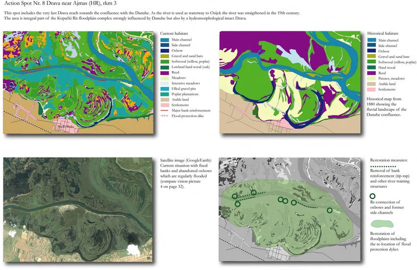
5.1. Restoration spots with status, development and • Photo documentation
proposed restoration measures
Eight initial action spots were selected to show examples for What is needed for the further detailed planning of
possible restoration projects. All together the action spots restoration sites?
have a potential project size of nearly 16,000 ha (about
12,200 ha in the active floodplain (between the existing For the detailed suitability and project planning the
flood protection dykes) and 3,800 ha outside, requiring local following floodplain evaluation for proposed areas for
dyke re-location). reconnection can be given:
1. Landuse assessment (do flood tolerant forests, or
They involve the removal of about 20 km of bank meadows already exist or is the landuse unsuitable)
protection and side channel closures, the reconnection of 2. Water level dynamics (duration, frequency and amplitude)
45 kms of side-channels, the management or reconnection 3. Flow velocity and diversity (critical for vegetation -
of 10 oxbows and the floodplain restoration of about 3,000 standing water conditions - and fine sediment accumulation)
ha. 4. Floodplain relief (status)
5. Connectivity (status)
Which spots where selected? 6. Floodplain habitat diversity and management of existing
FFH habitats
The spots were selected based on:
• The presence of floodplain remnants and partial Further aspects of land availability and ownership or
connectivity compensation for farmers and flood protection (flood
• The presence of larger areas without intensive retention efficiency) are important. Without the acceptance
landuse (settlements) and awareness in the local population, restoration measures
• The location of the flood protection dykes (and space are difficult to realise.
Fig. 49 (next page): Location of the eight action spots
for re-location)
Drava Vision 2020 22Drava Vision 2020 23
Drava Vision 2020 24
Drava Vision 2020 25
Drava Vision 2020 26
Drava Vision 2020 27
Drava Vision 2020 28
Drava Vision 2020 29
Drava Vision 2020 30
Drava Vision 2020 31
5.2. Drava and Mura from above: The living Vision

The following images (three of them are marginally changed
by photomontage) give an impression of restoration targets
for both the Lower Mura (left) and Drava (right) showing
existing short stretches which could serve as reference sites.
Both upper images belong to stretches with more islands
side-channels and gravel and sand bars and the lower images
represent the typical meander rivers of lower stretches with
large point bars and steep banks (Credit: A. Mohl/WWF).

                                                                                              3

                                                                 1

                                                                 2                            4
                                                                     Drava Vision 2020   32
6. Photo gallery: Nature and people along the Drava and Mura Rivers
Credits: Jiri Bohdal, Arno Mohl/WWF, Mario Romulic (www.romulic.com)
Drava Vision 2020 337. References PRPIĆ, B. (2001): The effects of hydro-technical Conservation/SFF & Atta.45 Tryckeri AB, Stockholm: 133-
interventions on the stability of pedunculate oak (Quercus 140.
robur L.) stands in Croatia on the example of the Novo SCHWARZ U. (2007): Pilot Study: Hydromorphological
BM LFUW, GOVERNM ENT OF CARINTHIA (2008): Is the
Virje Hydropower station. In: Šumarski List, Croatian survey and mapping of the Drava and Mura Rivers. IAD-
Drava River Basin management sustainable and well on the forestry society, No. 7-8, 2001 Zagreb. Report prepared by FLUVIUS, Floodplain Ecology and
way? International Symposium “DRAVA RIVER
VISION”. 23.-25. September 2008. Austrian Federal RÁKÓCZI, L., SZEKERES, J. (2008): Environmental River Basin Management, Vienna. 140 pp.
Ministry for Agriculture, Forestry, Environment and Water effects of industrial dredging on alluvial riverbeds. WWF (2002a): Natura 2000, Chance für Natur und
Management, Abteilung II/4. Government of Carinthia, International Symposium „DRAVA RIVER VISION", 23- Wirtschaft, Region „Steirische Grenzmur“, Vienna.
Department of Water Management. Report. Vienna, 25 September 2008, Maribor, Slovenia
Klagenfurt. WWF (2002b): Waterway Transport on Europe’s Lifeline,
REEDER, D., MOHL, A., SCHNEIDER-JACOBY, M., the Danube. Vienna. 134 pages.
BOGNAR, A. (1990): Geomorfologija Baranje. STUMBERGER, B. (2006): The protection of the Drava-
Znananstvena monografija. Zagreb. Mura wetlands. In “The Green Belt of Europe, From Vision WWF Austria (2006): Saving a picture of Beauty. Brochure.
to Reality”, IUCN, Gland/Switzerland and Cambridge/UK. Vienna.
BIONDIC, D., (1999): Erozia korita donje Drave,
Gradevinar 51, pp. 321-329 SCHNEIDER-JACOBY, M. (2005): The Sava and Drava WWF/EuroNatur (2005): Drava and Mura - Living Rivers
Flood Plains: Threatened Ecosystems of International or Canals? Unpublished.
EURONATUR (1999): European Lifeline Drava-Mura. Importance. Large Rivers Vol. 16, No 1-2; Arch. WWF/UNDP (1999): Evaluation of Wetlands and
Map 1 : 500 000. PIN Matra Programme, Radolfzell. Hydrobiol. Suppl. 158/1-2: 249-288. Floodplain Areas in the Danube River Basin. Vienna
HRVATSKA ELEKTROPRIVREDA (2002):
SCHNEIDER-JACOBY, M. (2002): European Life Line
Transboundary Environmental Impact Assessment Espoo
Danube-Drava-Mura - a concept for sustainable tourism
Convention, Supplementary material. Elektroprojekt. development. Reinventing a Tourist Destination -
Zagreb. International Tourism Research Conference 50th
LHW Sachsen-Anhalt (2006): Deichrückverlegung im anniversary - journal TOURISM / TURIZAM, Dubrovnik,
Bereich des Lödderitzer Forsts im Rahmen des 18-21 October 2002, Institute for Tourism, Zagreb: 81-84.
Naturschutzgroßprojektes Mittlere Elbe. Präsentation Nov. SCHNEIDER-JACOBY, M. (1998): Odrzivi razvoj
2006. Pomurja i Podravine kao magucnost unapredenja granicnog
MOHL, A. (2004): Life River restoration projects in Austria, prostora izmedu Austrije, Slovenije, Hrvatske i Madarske
3rd European Conference on River Restoration, (Conf. (Sustained use of the Drava-Mura lowland as a bordering
Proceedings), 17-21 May 2004, Zagreb, Croatia. region of Austria, Croatia, Slovenia and Hungary).
MOHL, A. (2001): The nesting of the Little Tern Sterna Proceedings International Conference Sustainable Use of
albifrons on the Drava River in Croatia and Hungary, the Lowland Rivers and the Protection of Nature and
Acrocephalus 22, (104-105): 35-39, Ljubljana, Slovenia. Environment, Hrvatsko Sumarsko Drustvo i Euronatur,
Zagreb: 70-82 (Engl. 154-155).
MOHL, A. & SCHWARZ U. (1998): The impact of the
Hydroelectric Power Plant Project on the flow of the Drava SCHNEIDER-JACOBY, M. (1996): Drau und Mur - Leben
River between Botovo and Ferdinandovac. In: Sustainable durch Flußdynamik. Naturerbe Verlag Jürgen Resch,
Economic Use of the Lowland Rivers and Protection of Überlingen.
Nature and Environment (Proc. Int. Conf.) 118-134. SCHNEIDER-JACOBY, M., MOHL, A., SCHWARZ, U.
EURONATUR, Hrvatsko Sumarsko Drustvo, Hrvatsko (2003). The White-tailed Eagle in the Danube River Basin.
Energetsko Drustvo, Zagreb. Helander, B., Marquiss, M. & Bowerman, W. (eds.) 2003.
SEA EAGLE 2000, Swedish Society for Nature
Drava Vision 2020 34You can also read