Drones: Benefits study - High level findings - Ministry of Transport
←
→
Page content transcription
If your browser does not render page correctly, please read the page content below
Drones: Benefits study
High level findings
Prepared for:
 Ministry of Transport
 Ministry of Business, Innovation and Employment

The inputs, comments and feedback of the project steering group and Ministry of Transport and Ministry
for Business, Innovation and Employment staff are acknowledged.

Document reference:     MOT009.18
Date of this version:   04 June 2019
Contact person:         Lawrence McIlrath
                        lawrence@me.co.nz
                        DDI: 09 915 5523
                        Mob: 021 042 1957

www.me.co.nz
Disclaimer: Although every effort has been made to ensure accuracy and reliability of the information
contained in this report, neither Market Economics Limited nor any of its employees shall be held liable for
the information, opinions and projections expressed in this report.

ii
Executive Summary
Drones will provide unprecedented levels of access to airspace, which has been prohibitively costly and
difficult to access for a majority of businesses to date. This new access could lead to fundamental changes
in the way New Zealanders conduct business, move goods, and travel.
Commercial demand will account for most of the growth in drone use over the next 25 years. New Zealand,
and most other countries, are in the early stages of developing and fostering commercial uses for drones.
This means it is both difficult and vitally important to understand the potential benefits of drones, and what
is needed to enable and support those benefits.
This study looks at the potential economic value that drone use could provide New Zealand over the next
25 years. It also attempts to define a “drone sector” by identifying those sectors of the economy which
could make direct use of drones, or improve their own operations through drone use.
Modelling the potential economic value of drone use considered both how the market understands drones
today, including how businesses already use drones as an input or part of a business process, and
stakeholder input and expectations around how drones could best be used in the economy. Modelling was
not undertaken around the potential social impacts of drones, or the impact of drones on employment in
New Zealand. While the findings of the study are indicative only, the key outtakes include:
      •   Drones could assist in lifting productivity across large parts of the economy
      •   Drones have the potential to transform existing industries and create new industries, particularly
          in the areas of commercial deliveries and inter-regional passenger transport.
      •   With moderate commercial uptake rates, the potential value to the economy of increasing line of
          sight (LOS) drone use over the next 25 years, ranges between $2.5 billion and $3.9 billion, with
          dairying contributing between $1.3 billion and $1.5 billion
      •   Drones flights beyond the visual line of sight (BLOS) could increase these figures to between $3.2
          billion and $5.0 billion to the economy per year
      •   Using aspirational figures for uptake rates, appetite to shift towards drone technologies and the
          number of potential uses, the potential value to the economy increases to between $4.6 billion
          and $7.9 billion.
      •   New and innovative uses for drones, that have not yet been conceived, could provide even further
          benefits and value to the economy.
The study also highlights the challenges around drone uptake and use. As with any new and transformative
technology, a key challenge lies in the limited track-record of drones to demonstrate their commercial
value. In addition, social acceptance, scale of production, and the regulatory environment will all influence
uptake. Uptake will be particularly impacted in sectors with low margins, and in areas where alternative
innovative technologies may compete with drones, or they are not perceived to add value.
The findings from this study will inform the wider work programmes of the New Zealand Ministry of
Transport and the Ministry of Business, Innovation, and Employment around the value of drone use to the
New Zealand economy. It will also inform the approach to regulation and supporting technological
innovation in the drone space. The paper confirms that due to the potential scope of the benefits, a do-
nothing regulatory approach is not appropriate.

iii
Contents
1 INTRODUCTION ................................................................................................................. 1
1.1 PROJECT AIM ........................................................................................................................ 1
1.2 APPROACH ........................................................................................................................... 2
1.3 LIMITATIONS AND CAVEATS ...................................................................................................... 3
1.4 REPORT STRUCTURE ............................................................................................................... 4
2 DRONES IN CONTEXT......................................................................................................... 6
2.1 GLOBAL CONTEXT................................................................................................................... 6
2.2 NEW ZEALAND SITUATION ....................................................................................................... 8
2.2.1 Sectoral applications ..............................................................................................................9
2.2.2 High level estimates of current values ................................................................................ 10
2.2.3 Wider landscape ................................................................................................................. 11
2.3 ECONOMY-DRONE INTERFACE................................................................................................. 13
2.4 OUTLOOK ........................................................................................................................... 16
3 INDUSTRY ENGAGEMENT ................................................................................................ 19
3.1 MAIN POINTS ...................................................................................................................... 19
3.1.1 Point 1: Divergent views .................................................................................................... 19
3.1.2 Point 2: Market wants a proven solution ........................................................................... 20
3.1.3 Point 3: It is not just the drone .......................................................................................... 20
3.1.4 Point 4: Competing against alternatives ............................................................................ 21
3.1.5 Point 5: Getting scale ......................................................................................................... 21
3.1.6 Point 6: Two-part sector – leisure and commercial ........................................................... 22
3.1.7 Point 7: Regulatory environment ....................................................................................... 22
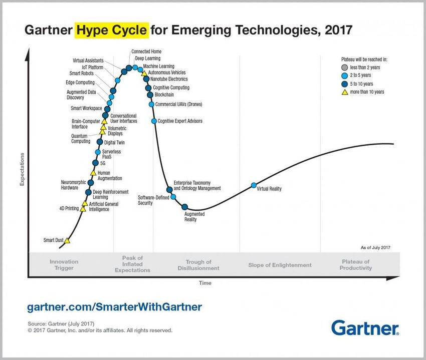
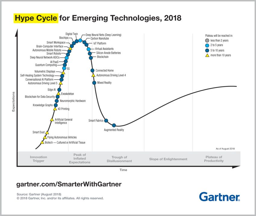
3.1.8 Point 8: Drones are over the hype-curve ........................................................................... 23
3.2 CONCLUSION ...................................................................................................................... 23
4 ESTIMATED BENEFITS ...................................................................................................... 24
4.1 PRIMARY INDUSTRIES............................................................................................................ 25
4.1.1 Dairying ............................................................................................................................... 25
4.1.2 Forestry ............................................................................................................................... 30
4.1.3 Other agriculture ................................................................................................................ 36
4.2 UTILITIES ............................................................................................................................ 38
4.3 TRANSPORT (PARCEL DELIVERY) .............................................................................................. 42
Page | i4.4 AIRPORTS ........................................................................................................................... 44 4.5 CONSTRUCTION ................................................................................................................... 45 4.6 PUBLIC SERVICE, SAFETY AND SECURITY..................................................................................... 47 4.7 OTHER ............................................................................................................................... 53 4.8 TOTAL EFFECT AND ASPIRATIONAL SETTINGS .............................................................................. 54 5 FUTURISTIC SCENARIOS................................................................................................... 56 5.1 CONNECTING REGIONAL NZ ................................................................................................... 56 5.2 DELIVERY OF GOODS USING DRONES ........................................................................................ 59 6 CONCLUDING REMARKS .................................................................................................. 61 7 LIST OF REFERENCES ....................................................................................................... 62 Appendices APPENDIX 1: SECTOR ENGAGEMENTS ......................................................................................................... 67 APPENDIX 2: BRIEF DEFINITION OF DRONES ................................................................................................. 68 APPENDIX 3: SECTORS THAT COULD USE DRONES (DIRECTLY OR VIA CONTRACTING)............................................ 70 APPENDIX 4: GARTNER’S HYPE CYCLE ........................................................................................................ 71 APPENDIX 5: HYPE CYCLE ......................................................................................................................... 72 APPENDIX 6: DAIRYING ASSUMPTIONS ........................................................................................................ 73 APPENDIX 7: DAIRYING - SENSITIVITIES ....................................................................................................... 75 APPENDIX 8: SUMMARY OF SCENARIO FINDINGS (ELECTRICITY SECTOR) ............................................................ 76 Page | ii
Figures
FIGURE 2-1: INDUSTRIES THAT OPERATORS SERVICE AND THE % OF NZ EMPLOYMENT IN THOSE SECTORS ............... 9
FIGURE 2-2: DRONE APPLICATIONS – GENERAL CATEGORIES ......................................................................... 15
FIGURE 4-1: ASPIRATIONAL (UNCONSTRAINED) OUTCOMES .......................................................................... 55

Tables
TABLE 4-1: DOTHISTROMA – ESTIMATED BENEFITS OF USING DRONES ............................................................ 33
TABLE 4-2: CYCLANEUSMA - ESTIMATED BENEFITS OF USING DRONES ............................................................. 34
TABLE 4-3: SHEEP AND BEEF (LOS) – SENSITIVITIES ..................................................................................... 37
TABLE 4-4: POTENTIAL BENEFITS FROM USING DRONES FOR PARCEL DELIVERY................................................... 43
TABLE 4-5: AVIATION’S ECONOMIC IMPACT ................................................................................................ 44
TABLE 4-6: DRONES’ POTENTIAL CONTRIBUTION VIA CONSTRUCTION .............................................................. 47
TABLE 4-7: SAR STATISTICS ..................................................................................................................... 49
TABLE 4-8: INCIDENTS PER 10,000 POPULATION FOR SAR AND SLS .............................................................. 50
TABLE 4-9: SAR – POTENTIAL BENEFITS (RANGE) ........................................................................................ 50
TABLE 4-10: POTENTIAL GAINS FROM USING DRONES IN FIREFIGHTING ............................................................ 52
TABLE 5-1: POTENTIAL GAINS OF USING DRONES FOR PARCEL DELIVERY ........................................................... 60

Page | iii
1 Introduction
Globally, there has been strong growth in research and development of new unmanned aerial systems and
the commercialisation of unmanned aerial vehicle (or drones) applications. Some drones are semi- or fully
autonomous and can operate independently of direct (immediate) human control. Drones can be equipped
with sensors and cameras enabling a wide range of uses. It is these wider uses that can deliver the
economic benefits. In effect, it is only when drones are connected with other technologies, that their true
economic value can be realised. Drones offer aerial mobility that allows the controller to remotely access
areas that were previously difficult, or dangerous, to access in a cost-effective, timely and safe manner.
Advances in sensing, measuring and optical technologies, combined with gains in drone capabilities have
driven great interest in using drones in new ways. However, there are still practical limitations, like payload,
battery life (range) and safety concerns that are inhibiting widespread uptake of drones.
Intuitively, widespread uptake of drone in the mainstream economy will deliver a range of new benefits to
New Zealanders. These benefits will arise through lifting productivity and other social effects like seeing
new/better imaging of remote natural landscapes. Increased drone usage could cause issues with privacy,
disruption of aviation services, and airspace management. These issues may require appropriate
technological and/or regulatory interventions to be put in place.
Drones come in different sizes and styles. They range from small handheld devices to large devices capable
of carrying large payloads. Drones can be rotary wing (helicopter or multicopter), fixed wing (airplane) or
a combination.
Users generally fall into one of two categories:
 • Commercial – where a drone is used in a business context, with some form of revenue or business
   purpose, or
 • Recreational – where flying is performed as a pastime, hobby, leisure or in a sporting capacity (i.e. non-
   commercial).

Emerging technologies and advances in drone equipment are presenting businesses with ways to change
how they work, do business and lift productivity.

1.1 Project aim
It is our understanding that this project sits within a wider work stream and that it will inform other project
pieces. Ultimately, this project is concerned with understanding the potential benefits of drones to New
Zealand. This research adds to the understanding by using a scenario approach to assess the potential
economic shifts that could occur under different growth assumptions. The scenarios focus on different
economic sectors and consider the potential gains to those sectors. There are many unknowns around the
use of drones and the supporting technologies since they develop in parallel to other technologies and
compete with (or substitute) other applications. It is not possible to forecast the future; this work makes
assumptions around uptake rates and the potential outcomes. The assumptions are based on a mix of
available literature, feedback and information from the industry, and our own judgement.
The aim must be viewed in the context of a wider research agenda i.e. what the potential benefits could
be to New Zealand of establishing itself as a ‘world leader in the testing and development of UA?’ This
question has several layers. Looking at it from an UA-sector level suggests that the benefits could arise

Page | 1
through lifting ‘internal industry practice1’ and ‘developing the technology and know-how and exporting it
(independently of local industry)’. Both approaches have merits, but one focuses on ‘using UA and
developing the applications’ and the other is about ‘developing the technical systems’. Dealing with the
real-life challenges, are often addressed by developing the applications and systems in parallel.
Nevertheless, it is important to understand the attributes of the different parts – individually and
collectively so that it can inform policy processes of Ministry of Transport (MoT) and the Ministry of
Business, Innovation and Employment (MBIE).

1.2 Approach
The project was delivered using a staged approach with four steps as summarised below:
1. Review past studies and international literature: The project started by reviewing the existing
   knowledge base with a view to develop a set of baseline metrics. In parallel with this, the drone sector
   was mapped, showing important linkages and relationships between users and providers. Next,
   international trends and developments were reviewed. This forms a wider context within which to
   view the sector. Most of the available literature focused on sector level applications. We worked with
   the Ministries2 to identify relevant sources and datasets that they held, and a general information gap
   was identified.
2. Engagements: Most of the available information covering drones is international, specifically the
   United States of America and Europe. There is very little primary research about drones and their use
   in NZ. The literature was supplemented with sector engagements. Interviews were conducted with
   several role-players and stakeholders covering different parts of the drone landscape, including:
        a. Businesses that use drones as an ‘input’ or part of the business process,
        b. Businesses that provide drone-based services,
        c. Businesses that supply the drone sector covering, hardware, software and
            supporting/complementary technologies, and
        d. Government agencies and regulators.
   Semi-structured interviews were used to canvas the following aspects:
        a. Scope of current activities, e.g. distribution across New Zealand, key clients (sectors), type of
            service being delivered, industry dynamics3, growth strategies and sector outlook,
        b. Development challenges and opportunities,
        c. Regulatory issues, constraints and safeguards as well as emerging priorities,
        d. Applications and market uptake of new approaches,
        e. Impacts of drones on business practices, advantages and trade-offs associated with drones,
        f. Interactions and cross-over with other technologies (e.g. the Internet of Things or IoT),
        g. Views on the future of drones and the applications.
   Appendix 1 lists the parties that were interviewed.
3. Scenarios and modelling: Insights from the engagements were combined with New Zealand specific
   information and international literature to define different growth pathways (scenarios). The pathways
   reflect different assumptions around the growth drivers, sector uptake rates and outcomes. Several
   scenarios are modelled to assess the potential economic effects of drone-technology and to show the
   relative sensitivities.

1 E.g. exporting the know-how developed in the dairy-pasture management vs developing it in-house.
2 Ministry of Transport and Ministry of Business, Innovation and Employment.
3 This includes matters like the sources of inputs (imports vs exports), suppliers, users and market development.

Page | 2
4. Effects and implications: Based on the modelling work, the effects and implications of the different
growth pathways are explored.
It is worth noting that it is beyond the scope of this assessment to quantify all effects4, across the entire
economy. Instead, a high-level commentary on the mechanisms through which drones interact with other
sectors is provided.
1.3 Limitations and caveats
The drone sector is complex and constantly evolving. This assessment attempts to develop a high-level
picture of how drones could be used in key sectors and what the potential benefits could look like. The
very nature of drones, and the uncertainties around future uses, means that the results are speculative.
Our assessment relies on available information and there are caveats underlying the assessment. The
following limitations and caveats apply:
• The scenarios reflect assumptions around how drones interact with the rest of the economy. There
is little official information about drones, their applications, the direct costs and so forth. The
results are not forecasting, or projections of the future – they are simply scenarios reflecting
different growth outlooks. In addition, we assume that the overall business models (e.g. input
structures and cost structures) would remain constant. This project does not adjust for, or attempt
to estimate, the new business structures arising from new (drone) technology.
• While we comment on the potential economic effects (or contribution), the potential costs and
benefits, undertaking a full economic impact assessment5 or a cost-benefit analysis of drones is
outside the scope of this work. The focus is on the benefit-side but where possible we net out the
costs. In addition, increased drone use will see a lift in risks (e.g. an operator losing contact with a
drone and causing an accident). Valuing these risks is a complex task and it would be useful to
understand the drivers and potential outcomes of these risks. The risk assessment is beyond the
scope of this report. Once they are better understood, the benefits should be compared against
the risks.
• A large portion of the international literature covers military applications of drones. Military
applications are beyond the scope of this research. Nevertheless, military-focused R&D and
innovations are often commercialised and applied in a civil context. That is, developments in the
military arena often end up in civil applications.
• It is beyond the scope of this study to explore the technical considerations, issues and their
implications. Examples include how to manage shared airspace, ethical considerations of drones,
human technical-interface issues, interoperability between systems and issues associated with
guidance, navigation and control (GNC) and so forth. It is assumed that the technical
considerations are addressed, and that drone-technologies/applications can be used.
• The sector mapping and definitions presented in the report are based on international literature
with adaptations to reflect New Zealand conditions. These are working definitions and they will
change over time. The sector definitions are not official government policy positions.
• Accessing business-specific data is often challenging with confidentiality constraints. We relied on
published information as far as possible. We did not peer review the published information, and in
most cases, the low or conservative positions are used in this work. We did not undertake primary
(survey) research but we did engage with a selection of industry stakeholders. This implies that
4 Like the employment and labour market shifts arising from new technologies associated with drones and the effects they unlock.
5 If the economic impacts are assessed, then Multi-regional Input-Output (MRIO) or Computable General Equilibrium (CGE) models could be used.
Page | 3the ‘sample’ was relatively small and so the biases (conscious or unconscious) of those interviewed
are reflected.
• The project did not use the Longitudinal Business Database (LBD). The LBD contains micro-data
that researchers can access to investigate different business features. Using the LBD for this
project was not possible but it would be valuable to include the LDB in future assessments.
• How an industry responds to new technologies, the uptake rates and effects are not always known
because they are often ‘future’ outcomes. Similarly, if the decision to replace one technology with
another is made, there may be other flow on effects in other parts of the economy. For example,
shifting from diesel power to electric power causes changes in those businesses associated with
providing diesel. Similarly, if one sector grows it could attract resources (like labour) away from
other sectors. These flow-on effects are beyond the scope of this report.
• Incorporating drones in normal, day-to-day operation of business could lead to short term costs,
like sunk costs associated with historic investments. The values of such losses are not included in
this assessment.
• This assessment’s main focus is on the benefits of drones. However, where possible, we illustrate
the net benefits i.e. the benefits excluding the direct costs associated with delivering the
improvements.
• There are several unknowns and uncertainties around drone uses and the direct costs (initial
investment and ongoing expenses) associated with drones. We did not undertake a full cost-
benefit analysis of drones. Aspects like the cost to refurbish, or renew, drones are not reflected.
Similarly, the environmental costs and risks of drones are beyond the scope of this work.
• The assessment contains several forward-looking parts. It was not the intention to undertake an
economic forecast of the New Zealand economy. Where we use sector specific outlooks, we rely
on official forecasts, but these datasets do not align with the timeframes used to look at the longer
time (25 years). We use basic projections that align with historic trends to inform the sector
outlooks, but they are tempered (lowered) to take a conservative position.
• The work does not include an assessment or analysis of the durability of drones – this point has
several dimensions:
o The replacement cost of drones at the end of their useful lives and the average useful live
(i.e. how many flying hours could be expected from drones),
o The ecological costs associated with manufacturing or disposing drones. This relates to
components like the batteries, airframe and electronics. We anticipate that most parts
would be recyclable but there are costs associated with recycling and disposal. The
assessment considers the potential benefits of using drones. We did not undertake a
‘whole-of-life’ assessment of all the costs (associated with drones)6. Including these costs
would reduce the net benefits outlined in the report.
1.4 Report structure
The report is structured as follows:
Section 2 provides a basic context of drones by defining ‘drones’ (for this study), highlighting recent global
trends and summarising the known New Zealand landscape.
6 Such an assessment was beyond the scope of this report.
Page | 4Section 3 summarises the key points and themes that emerged from the sector engagements. This section sheds light on the issues and challenges that can be expected when rolling out drones. Section 4 presents the potential benefits that drones could deliver. The discussion focuses on selected sectors, presents the assumptions, results and sensitivities. The section concludes with a summary of the findings and illustrates the scale of benefits under aspirational settings. Section 5 presents a short discussion of two futuristic scenarios. The report ends with some concluding remarks regarding drones and the key points. Page | 5
2 Drones in context
Drones can be traced back to the late 1910s when they were applied in a military context. Recently, drones
have entered the mainstream and are being used to support a range of applications across the economy.
There is a general perception that drones are mostly used for leisure activities. This perception is somewhat
misplaced because different technologies7 are being combined and these new applications are disrupting
traditional business models. But, as this section will show, in terms of numbers, the leisure market still
dominates the drone landscape. Further, the same technology combination (e.g. drone and camera) can
be used across different sectors, in positive and negative ways.
This section starts with a brief summary of international trends to set the scene. Next a high-level
description of the New Zealand drone market is presented.
Drones are described using many different names, including:
     •       Unmanned Aerial Vehicle (UAV),
     •       Remote Piloted Aircraft (RPA),
     •       Remote Piloted Aircraft System (RPAS),
     •       Remote Piloted Vehicle (RPV),
     •       Unmanned Aerial System (UAS),
     •       And others.
Each name has a specific, technical meaning, referring to different technologies and human involvement.
Appendix 2 presents a brief description and overview of drones, some specific meanings and general
categories. In this report, we use the term ‘drones’ loosely, referring to ‘unmanned aerial vehicles’ in a
broad sense.

2.1 Global context
There are several, high level estimates of the drone market’s value and its outlook. These estimates are
based on numerous assumptions and caveats8. The estimates have been prepared by global consulting
firms and concentrate on individual regions (e.g. Europe) or countries (e.g. United Kingdom, UK). The
estimates paint a very positive picture showing strong growth in the short and medium term. The estimates
show:
         •
         Globally, the total addressable value of drones is estimated at US$127bn (2015-value),
         •
         A European valuation estimates that the value of drones will reach EUR10bn, by 2035 and over
         EUR15bn (annually) by 20509.
      • In the UK10:
            o Productivity gains across UK industries could deliver net cost savings of up to £16bn11 by
                2030.
     • In the USA:

7 For example, a high-resolution camera is combined with the flying platform the drone provides.
8
  As is this study.
9 SESAR. November 2016. European Drones Outlook Study – Unlocking the value for Europe.
10 (PWC, 2018)
11 PricewaterhouseCoopers. 2018. Skies without limits: Drones – taking the UKs economy to new heights.

Page | 6
o The economic impact of integrating drones into their National Airspace System is
estimated to total more than $13.6bn in the first three years and expected to grow to
$82.1bn between 2015 and 2025.12
o Consumer Technology Association estimated that 2.8m commercial drones were sold in
the USA (in 2016/17) and that the total revenue came to $953m. BI Intelligence expects
drone sales to top $12bn by 2021 with an important part of sales coming from personal
drones (used for film-making, recording, still photography and gaming). The uptake profile
for personal drones is expected to match that of GoPro. (Meola, 2017)
Some of the studies were performed as part of thought leadership and insights work without a clear
indication of who the commissioning party was. And, some appear to the ‘marketing-type work’. This
makes it difficult to identify the purpose (research question), methodology(ies), limitations and
assumptions and so forth. Similarly, in some instances, the reports were prepared by sector/industry
associations, and could be seen as presenting a ‘best case’ scenario for the purpose of lobbying and industry
marketing activities. Some reports were prepared for government entities (e.g. the European Commission)
and apply scenario approaches to show the range of potential impacts. These government reports are
more transparent and appear to use less bullish
assumptions. These reports offer some insights into
the anticipated growth and distribution of drones Even if the more pessimistic values are used, the
across the different economies. They tend to be more potential impacts of drones are substantial.
conservative and claim lower benefits. Regardless of Drones are seen as a potential driver of
the sources used, the key takeaway is that the global productivity and growth. Therefore, a do-
outlook for drones is very positive. nothing regulatory approach is inappropriate.
Even if the more pessimistic values are used, the
potential impacts of drones are substantial. Drones are seen as a potential driver of productivity and
growth. Therefore, a do-nothing regulatory approach is inappropriate.
In terms of the sectoral distribution of effects, the benefits generally fall across the same/similar sectors,
regardless of region. The reports show:
• Infrastructure, construction and manufacturing activity will gain from drones. Globally,
infrastructure will see around 36% of the realisable benefits. In the UK, construction and
manufacturing will see a quarter of the cost savings (25%).
• Agriculture and primary sectors (including mining, gas and electricity) will see a large portion of the
effects. Globally, agriculture is expected to capture 26% of the value.
• Transport will capture around 10% of the global benefits and in the UK, 21% of the costs savings
will accrue to transport and logistics.
• Public security will account for 8% of global benefits and in the UK, it is estimated that ‘public and
defence, health and other services’ will see around 17% of the cost savings that drone could deliver.
Using the SESAR work (European Union, 2016), a drone-population ratio can be estimated. Such a ratio
gives a useful benchmark to compare New Zealand data against. Using EU research and combining it with
population data13 and projections return the following ratios (note the different timeframes):
12 Based on a 2013 report by the Association for Unmanned Vehicle Systems International.
13 (Eurostat, 2018)
Page | 7• Government and commercial drones:
o 3.8/10,000 people by 2025,
o 7.9/10,000 people by 2035.
• Leisure drones:
o 98.3/10,000 people by 2015,
o 134.5/10,000 people by 2025.
These ratios show that the leisure market is expected to remain a large part of the drone-fleet. Over time,
the density of drones (relative to the population) is expected to increase. It is also this part of the market
that has the highest propensity to use drones in a rogue manner (as seen in the airport disruptions in
London around Christmas 2018 and January 2019).
2.2 New Zealand situation
There is no official information about the number of drones, commercial or leisure users, in New Zealand.
Using the findings of the 2017 report by Colmar Brunton for the Civil Aviation Authority (CAA) and
combining it with recent population projections suggests that there are 308,00014 drone users in New
Zealand. However, this figure has been disputed. Applying the information in the Colmar Brunton report
differently, presents an entirely different picture with the number of drones estimated at 77,600 (in 2017).
This is considerably lower than the Colmar Brunton figure but, when expressing the estimated on a per
capita basis, the lower figures are better aligned with the European ratios. This estimate suggests that
there are 106 drones per 10,000 New Zealanders. This is broadly consistent with the rates identified in the
EU.
The 2018 Drone Tracker report (based on a survey of the 7,000 members on the Airshare database) paints
a clear picture of the spread of commercial operators across New Zealand. Some of the key points shown
and suggested in the Drone Tracker report are:
• Leisure/recreation users:
o Leisure/recreation users spend $1,000-$2,000 on drones and do most of their flying in
their backyards, local parks or beaches. This suggests that they use drones as a form or
relaxation and often combine it with photography equipment to capture land/cityscapes.
o The distribution of recreational users is broadly in line with New Zealand’s population
distribution.
o More than half (57%) of recreational users Drones are used to lift service levels, and
fly between one and three times a month. only a small share of operators have drones
at the centre of their businesses. Drones
And, one in five (19%) recreational users
operators are based in the main, urban
operate their drones less than once per
centres.
month.
• Commercial operators:
o Tend to use drones to supplement their existing business activities (54% of respondents).
o Offer drone services as part of the overall business but drone services are not the ‘core
business’ (30% of the respondents).
o A relatively small proportion (14%) of commercial operators provide drone services as part
of the core business.
14Applying the ratios in the Colmar Brunton report differently, considering the margin of errors, restricting the age profile, and adjusting the
population to households (not people), return the substantially lower estimate.
Page | 8o Almost a third (27%) of drone operators are located in Auckland and 17% are based in
Canterbury. Apart from some minor imbalances, there appears to be a reasonably good
alignment between where drone operators are located and where most flying takes place,
with Auckland the exception. The data suggests that some operators are based in Auckland
but ‘export’ their services to the rest of NZ.
There is another segment of drone user – international tourists that use drones while they are visiting.
Colmar Brunton asserts that 6 in every 100 overseas visitors (over 15-years old) had flown a drone while
they were in New Zealand. This suggests that in 2018 (YE June) there were around 204,250 tourists that
used drones while they were in NZ. This estimate is based on tourist departures. In light of the anticipated
ongoing growth in New Zealand’s tourism sector, this figure will grow. It is however not known from the
research if these tourists came to New Zealand for the sole purpose of operating their drones or if this was
simply incidental. This means it is difficult to put a value on drones in the context of tourist spend.
2.2.1 Sectoral applications
There is little official information on commercial operators in New Zealand. The Airshare database (held
by Airways) provides useful information about the sector. In 2018, a survey was circulated amongst
members to generate a user profile. Figure 2-1 shows the sectors/industries that use drones (as a service)
Figure 2-1: Industries that operators service and the % of NZ employment in those sectors
Note: Figures do not add to 100% because an operator can service. Based on Airways (2018).
The figure shows that currently, most commercial operators focus on the real estate and construction
sectors with between 40% and 38% of operators servicing these two sectors. This is followed by:
• Film/television (29%),
• Surveying (28%),
• Agriculture (23%),
Page | 9• Events (23%),
• Local government (22%),
• Other sectors (18%) and
• Infrastructure providers (15%).
It is worth noting that the NZ experience (i.e. sectoral distribution) broadly mirrors the international
experience15 (see Section 2.1) with infrastructure,
construction and manufacturing activity seeing a large Drone service providers interact with the
share of drone use. This is also the case if services wider economy in a way that broadly mirrors
related to the wider construction sector, like surveying, international experiences. That is, they tend
are considered. Agricultural applications feature to service the same type of sectors.
relatively high – again consistent with international
experience. This is followed by public security.
Combining public security and associated sectors, as reported in the Airways report, again confirms a
similar pattern for New Zealand. Military, emergency services, government and local government users
returns a total share of 47% suggesting that almost half of the drone service providers engage with public
services.
Comparing the sectors currently receiving drone services against the employment levels show a mismatch.
Around 40% of operators service construction and real estate but these two sectors are small in the NZ
context with 1.2% and 1.6% of employment16 each. Half (47%) of service providers work with public
security and services but this sector accounts for five per cent of employment. This mismatch also shows
up in the spatial distribution of commercial service providers. Drone operators are located in urban areas.
A large portion of New Zealand’s economy takes place in rural areas.
2.2.2 High level estimates of current values
As illustrated above, there is little existing data on drones, their use and the link to economic value that
they create. The Drone Tracker report (Airways, 2018) is based on the responses of 579 commercial
operators and there are over 7,000
registered operators. This includes both
recreational and commercial users. The potential benefits are estimated at between
Assuming that the responses are $154m and $216m. These figures reflect a very low
representative of the number of drones as growth outlook and should be seen as the minimum
estimated using the Colmar Brunton data, values (i.e. without any real further uptake of new
we estimate that there are between 1,500 opportunities, the drone industry maturing, or new
and 1,800 commercial drones in New applications being developed).
Zealand. That means that the commercial
survey covered between 32% and 39% of
commercial operators.
Based on the Drone Tracker report, drone-based company revenues17 are estimated to be in the order of
$162m - $194m. Looking forward, more than half of drone operators expect strong growth. Including this
15 As explained by the envisaged benefits (not users).
16 Based on 6D ANZSIC classification.
17 Applying the ratios to the response returns a turnover estimate of $69m i.e. using only the returned sample.
Page | 10growth lifts the turnover to $178m - $213m. Over a ten-year period, the drone sector’s potential turnover18
is estimated at between $1.3bn and $1.8bn – using a conservative 2% annual growth. Taking the turnover
estimates and adjusting for the cost of goods sold, employment and taxes, provide a rough proxy for the
benefits drones will deliver19 if the current conditions (and sectoral use rates) do not change. The potential
benefits are estimated at between $154m and $216m. These figures reflect a very low growth outlook and
should be seen as the minimum values (i.e. without any real further uptake of new opportunities, the drone
industry maturing, or new applications being developed).
Drone operators are actively engaging in R&D, with 36% of the respondents indicating that they will be
increasing their R&D spend. Based on the data in Drone Tracker, the sector spends between $15m and
18m on R&D, and the sector indicated a strong lift in R&D spending. Based on the feedback, R&D is
expected to grow to $21m - $25m over short term.
2.2.3 Wider landscape
Undertaking R&D and commercialising the outcomes are key parts of building productivity. Innovation
focused businesses tend to grow faster, pay higher salaries and wages and are more competitive on the
global stage. Many of New Zealand’s universities, Crown Research Institutes and companies engage in
R&D. Some of the R&D is privately funded and other workstreams are funded through research funding
like the Endeavour Investment Fund. The New Zealand Government is also working directly with
international companies to undertake their research in New Zealand. For example, Airbus is seeking out
opportunities to support the development and adoption of new and innovative space data technologies.
This includes the use of drones (NZ Government, 2018). Another example of private sector research and
development taking place in New Zealand is Zephyr Airworks20. Unfortunately, information on the
economic investment flowing to New Zealand to undertake the R&D is confidential so it is not possible to
quantify the benefits. The main benefit flowing to New Zealand is in the form of the foreign direct
investment. But, considering the media releases following (non-FDI) benefits are identified:
• Labour market benefits from knowledge dissemination and sharing: Zephyr is working with New
Zealand universities to develop the skills it needs. Media releases suggest that most of the direct
employment is based in the USA and three direct employees in New Zealand. It is not known how
many of these positions are actually filled. The labour market benefits include the direct
employment opportunities that are created. It also includes a lift in the technical knowledge and
capability. The opportunities are also high(er) quality jobs paying premium salaries. At the time of
writing, the following positions were being recruited for (to be in New Zealand): aircraft technicians
and flight test engineers.
• Building New Zealand’s profile on the international stage: hosting innovative companies to test new
products in real life conditions is consistent with the government’s work to attract future-focussed
technologies to develop their products in New Zealand. In turn, this will assist in diversifying the
economy and lifting resilience. Ultimately, by working with international companies (like Kitty-
Hawk via Zephyr Airworks) one of the weaknesses of the NZ innovation system is addressed,
specifically the drawing on connections to multinationals (Crone, 2018).
18 While turnover is not a ‘benefit’, it is easy to see the sector’s potential contribution.
19 The adjustments are based on the information published in Annual Enterprise Survey.
20 Zephyr Airworks is Kitty Hawk’s New Zealand operator.
Page | 11• Contribution toward clean energy transport options: New Zealand has a strong position on
environmental values. Supporting innovation and R&D that contributes towards lifting
environmental outcomes is consistent with these values
• Developing the wider airspace management landscape: Airways has announced that it is piloting
future technologies needed to support the arrival of autonomous flying vehicles in New Zealand
airspace. Airways also
intends to test the capability The Spark 5G Lab has a dual purpose. It’s primarily designed to be
of New Zealand’s existing a collaboration space for New Zealand innovators, entrepreneurs
telecommunications network and companies like Emirates Team New Zealand to have early
to track the likes of Zephyr
access to 5G, so they can test and develop products and
Airwork’s autonomous
experiences that will define the future. The lab will also host
vehicle Cora and drones in
technologies that showcase some of the possibilities and benefits
uncontrolled airspace and
of 5G such as robotics, virtual reality, facial recognition, Internet
enable better telemetry for
drone pilots. A by-product of of Things (IoT), smart cities, emergency services drones and
the increase in drones is that driverless cars. (Emirates Team New Zealand, 2018)
non-drone businesses are
investing in infrastructure
that support drones. This is because drones are stimulating demand for other services, like 5G.
In addition to the potential benefits of attracting and hosting drone R&D in New Zealand, drones can also
unlock other technologies and opportunities like ‘intelligent transport systems’. Recent research for the
Intelligent Transport Advisory Group (Deloitte Access Economics, 2018) put the local market for drones at
$725m with exports in excess of $520m.
Drones are also being used as part of active research. A review of the 2018 Endeavour Round Successful
Projects identified two projects with direct links to drones. The first project has a $1m contract value and
the second project has a budget of $999,000. Both projects have three-year timeframes. The projects
cover21:
• Drone flow: Aerial monitoring system for better river management: Drone flow is a research project
developing methods for measuring river flows from the air. It provides an efficient and cost-
effective way to collect high resolution data of water depths, velocities, and volumetric flow rate.
Using drones enables measurement of flows where existing methods are inadequate or dangerous,
such as during floods. River flows are measured to manage rivers, quantify floods and evaluate
physical habitat. This information is used to set minimum flows and limits on water take (e.g.,
regional council regulation of hydro-power and irrigation industries), and by central government
to monitor the state of New Zealand’s waterways. Existing methods of measuring river flows
struggle in shallow channels (e.g., summer low flows, braided rivers), or during large floods due to
floating debris, safety risks, and rivers overtopping their banks. These problems result in missing or
inaccurate data, particularly at low and peak flows. It is critical to improve flow measurement
capabilities now, since flow variability is expected to increase with climate change. The drone flow
system uses a pair of drones flying in formation. An upstream drone releases biodegradable tracer
particle, while a downstream drone records particle motion to resolve river surface velocities.
Depth is then calculated from surface waves, turbulence, through-water imagery, and spectral
attenuation. Physical habitat maps are generated by combining information on river velocity, depth
21 (Ministry of Business, Innovation and Employment, 2018)
Page | 12and substrate. Development of the drone flow system positions New Zealand as a world leader in
river remote sensing and provides a valuable tool for river managers tasked with maintaining or
improving the health of New Zealand’s river ecosystems.
• Reducing the impact of LED streetlights conversions on cultural and ecological values: Most of the
nearly 400,000 streetlights in New Zealand will be converted from largely high-pressure sodium
lamps (HPS) to more energy efficient light-emitting diodes (LEDs) by mid-2021. This conversion is
estimated to save $10 million/year and improve road user safety. However, LEDs emit more blue
light than HPS lamps, which reduces night-sky visibility and has adverse effects on marine,
terrestrial and freshwater ecosystems. There has been minimal research effort focused on
understanding and mitigating impacts of such widespread streetlighting changes, particularly in
New Zealand. This research project develops two tools that can be used to visualise different
streetlighting scenarios, from the fine-scale (Tool 1: drone-mounted sensors) to the city-scale (Tool
2: interactive lightscape maps). The research will use experimental tests of operational streetlight
types in the Christchurch Residential Red Zone to identify options that minimise impacts on cultural
(night-sky visibility) and ecological (freshwater insects) values. Experimental results will populate
an interactive map depicting lighting scenarios across Christchurch City, overlaid with areas of
cultural importance identified by the Ngāi Tahu Cultural Mapping Project (Kā Huru Manu), to
determine the impacts of LED streetlights on night-sky visibility and freshwater insects. Interactive
maps will allow councils and developers to identify areas of cultural importance and areas where
lighting impacts on ecological and cultural values are likely to be highest. These areas can be
prioritised for assessment for the more appropriate lighting scenarios identified in the
experiments. Together the tools will allow lighting project developers to realise economic and
safety benefits associated with LED conversions while minimising impacts on important cultural or
ecological values. We will trial the Christchurch Residential Red Zone, but our methods will be
transferable both nationally and globally.
The above shows that drones offer direct benefits to the R&D landscape by opening up new ways to collect
data and information. The role of drones is limited to transporting equipment, delivering research media
and/or collecting data. Nevertheless, it is important to realise that without the aerial platform, the work
would be delivered in other ways that might not be cost or process efficient.
The link between drones and other parts of the economy is clear. While the direct sales relationship is
relatively small (i.e. small number of local firms buying the goods), the links to the R&D community should
not be understated. Drones have links to areas like:
• Robotics,
• Advanced manufacturing,
• Engineering (mechanical, computer science, electrical and software engineering, and so forth),
• Wireless communications research,
These sectors make valuable contributions to the NZ economy.
2.3 Economy-drone interface
The conventional view that drones are only used for leisure or military applications is misplaced. There is
a growing number of business/commercial applications and the commercial sector is showing interest in
using the aerial capabilities that drone offer. Businesses are using other equipment and technologies to
make the most of these capabilities. Drone-technologies have developed a great deal over the past few
years and now include multiple uses, including:
Page | 13• Aerial photography,
• Gathering information in a post-disaster context,
• Thermal sensor for search and rescue operations, and firefighting,
• Geographic mapping of inaccessible terrain and locations,
• Building safety inspections,
• Precision crop monitoring,
• Law enforcement and border control surveillance,
• Storm tracking and forecasting, and so forth.
Most applications are associated with surveillance and optical measurement of some sort. But some
applications go beyond basic surveillance, photography or video. Drones are being rolled out to monitor
crops and collect pasture/soil data. New and recently developed uses that are being trialled, include:
• Retailers testing drones as a delivery option. Amazon has been testing Prime Air for several years,
and in 2017 it conducted the first public demonstration of the delivery system. While still in the
early stages, Walmart recently filed for a patent that included in-store drones (Stribling, 2018).
Pizza delivery was trialled by Dominos in Australia in2016 and 2017, respectively. In November
2016, a drone delivered a Domino’s pizza order to a customer in Whangaparaoa (north of
Auckland)22.
• Targeted delivery of rodenticide in conservation areas. On the Galapagos Island of Seymour Norte,
Drones have been used to fly autonomously along predetermined routes, dropping rodenticide
with precision, down to half a metre accuracy.
• The New York Police Department23 announced that it had acquired 14 drones to assist with policing
efforts. The drones will be used to police/monitor large events (e.g. concerts), in hostage situations
and in crime scene investigations. The NYPD indicated that it does not plan to use the technology
to enforce traffic laws or survey citizens. In the announcement, the NYPD said that there are 29
officers who are trained to use the drones.
• Lifeguards are testing new drone technology in Australia and have recently saved two people
stranded off the New South Wales coast24. The drones show a birds-eye view of the ocean before
ejecting a floatation device, which inflates when it hits the water. Other surf-life rescue
applications that are being trialled include pods designed to deploy automatic external
defibrillators (AEDs), flotation devices, electromagnetic shark repel devices, and personal survival
kits (that include water, a thermal blanket, a radio, and a first aid kit).
• Drone delivery service, Flirtey is partnering with a Reno-based ambulance service REMSA (Regional
Emergency Medical Services Authority), to send out defibrillators by air in response to cardiac
arrest-related emergencies25.
Ultimately, drones provide a platform from which different applications can be delivered. Figure 2-2 shows
the five general categories that applications fall in26.
22 (Domino's, 2016)
23 https://www.theverge.com/2018/12/4/18125725/nypd-drones-police-new-york-city-advocacy-groups. The NYPD has 36,000 officers and
19,000 civilian employees. The NYPD services 8.5m people.
24 January 2018. Website: https://qz.com/1182580/lifeguards-in-australia-make-history-by-using-a-drone-to-rescue-swimmers/. Date accessed
20/02/2019.
25 https://www.rgj.com/story/money/business/2017/10/10/flirtey-launches-first-drone-defibrillator-service-america/750868001/
26 Adopted from McKinsey & Company (2017).
Page | 14Figure 2-2: Drone Applications – General Categories
Adopted from McKinsey & Company (2017).
Page | 15You can also read