Drones in Humanitarian Action - A guide to the use of airborne systems in humanitarian crises
←
→
Page content transcription
If your browser does not render page correctly, please read the page content below
Drones in
Humanitarian
Action
A guide to the use of airborne systems in humanitarian crises
2

© FSD
3

This work is a product of our common vision in which
drones serve as tools to enhance human dignity and to
prevent and alleviate human suffering.
4

                     Acknowledgements
We would like to thank the many people who have been in-
volved in helping us put the report and the many case stud-
ies and meeting summaries on which this report is based
together: Our colleagues, Audrey Lessard-Fontaine, Sylvie
deLaborderie, Timo Luege, Martin Noblecourt, Friederike
Alschner, Fanny Bas and Jessica Du Plessis from CartONG;
Otto Simonett, Carolyne Daniel, Christina Stuhlberger at
Zoï Environment Network for design and creative guidance;
Patrick Meier and Peter Mosur, independent consultants
from the Humanitarian UAV Network; Kristin Sandvik at the
Peace Research Institute Oslo; David Guerin at Internation-
al Federation of Air Traffic Controllers’ Association and Bert
Rijk at FSD/Aurea Imaging.

We would also like to thank the many experts in the hu-
manitarian community who provided information and ad-
vice: Joel Kaiser at Medair; Sebastian Ancavil at the Inter-
national Organization for Migration (IOM); Oriol Lopez at
Medicins Sans Frontiers; Edward Anderson at the World
Bank; Ruslan Bobov at Focus Humanitarian Assistance;
Manuel Fiol at UNITAR/UNOSAT; Paul Vermeulen at Handi-
cap International, Nate Smith at HOTOSM/OpenAerialMap,
Haidar Baqir, Jose Odini and Luca Palermo at the World
Food Programme; Andrea Cippa at SDC; Chris Habib at iM-
MAP; Inna Cruz and Olivier Cottray at GICHD, Katy Qutub at
USAID; Mark Iliffe, cartographer; Allison Burtch at UNICEF;
Daniel Clauss and Romain Gauduchon at the EC Humani-
tarian Aid and Civil Protection (DG ECHO).

We would like to thank the funders for their support: EC Hu-
manitarian Aid and Civil Protection (DG ECHO) and Green
Cross Switzerland.

This report was authored by Denise Soesilo, Patrick Meier,
Audrey Lessard-Fontaine, Jessica Du Plessis and Christina
Stuhlberger, and led by Valeria Fabbroni. Denise Soesilo
was the project manager. Christina Stuhlberger managed
editorial production. Graphic design and layout was cre-
ated by Carolyne Daniel and Maria Libert. Timo Luege
provided editorial guidance; Geoff Hughes was the copy
editor. Images were provided by Mark Iliffe, Mapbox, Open-
StreetMap, Drone Adventures and Aris Messinis/Matternet
and FSD. Thank you.

This report was implemented with the financial assistance
of the European Union. The views expressed herein should
not be taken, in any way, to reflect the official opinion of the
European Union, and the European Commission is not re-
sponsible for any use that may be made of the information
it contains. http://ec.europa.eu/echo

                                                                   Funded by
                                                                   European Union
                                                                   Humanitarian Aid
5

                  Table of Contents

Acknowledgements							4
Acronyms and abbreviations						6
Executive summary							7
1. Introduction								9
2. Technology and actors						15
   2.1.   Drone types
   2.2.   Partnerships
   2.3.   Humanitarian aid workers on the use of drones
   2.4.   Applications
3. Mapping									23
   3.1. Drone mapping workflow
   3.2. Drones versus the alternatives
   3.3. Data processing and analysis
   3.4. Costs
   3.5. Emergency response mapping
   3.6. The way forward on mapping

4. Cargo delivery								35
   4.1.   Technology: State of the art
   4.2.   Actors
   4.3.   Business models
   4.4.   Cargo drones in conflict zones
   4.5.   Drones versus helicopters and planes
   4.6.   Regulations
   4.7.   The way forward for cargo drones

5. Other applications							47
   5.1 Search and rescue
   5.2. Monitoring and real-time information

6. Conclusions								53
Resources									55
Annex									57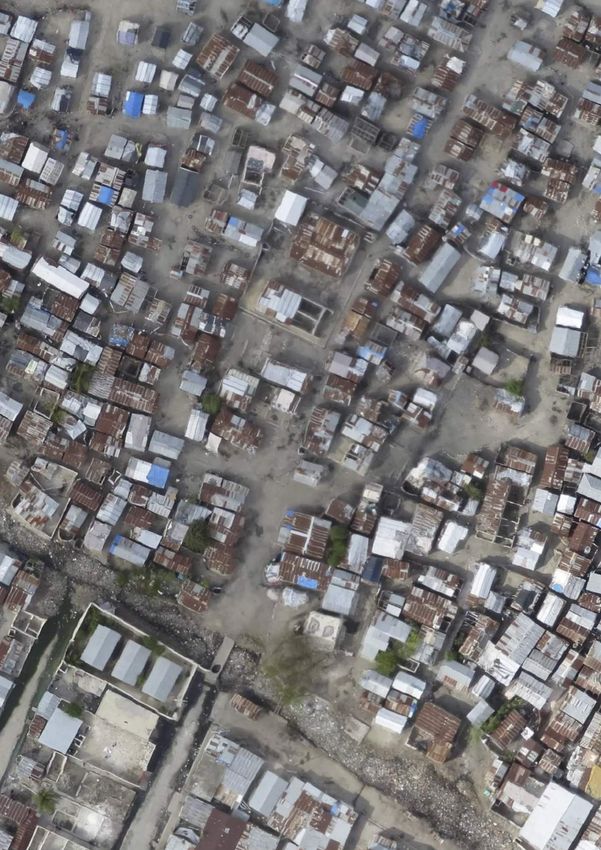
6

    Acronyms and abbreviations
BVLOS		    Beyond Visual Line of Sight
DVLOS		    Digital Visual Line of Sight
ELRHA		    Enhancing Learning and Research for Humanitarian Assistance
GAHI		     Global Alliance for Humanitarian Innovation
GIS		      Geographic Information System
GMFRS		    Greater Manchester Fire and Rescue Service
GSD		      Ground Sample Distance
HERMES     Highly Extensible Resource for Modeling Supply Chains
HOT		      Humanitarian OpenStreetMap Team
ICAO		     International Civil Aviation Organization
ICARUS     Integrated Components for Assisted Rescue and Unmanned Search Operation
IOM		      International Organization for Migration
MSF		      Médecins Sans Frontières
NGO		      Non-governmental Organization
OAM		      OpenAerialMap
OCHA		     United Nations Office for the Coordination of Humanitarian Affairs
OSM		      OpenStreetMap
PacDID		   Pacific Drone Imagery Dashboard
RMA		      Belgian Royal Military Academy
RPAS		     Remotely Piloted Aircraft System
SAR		      Search and Rescue
UAS		      Unmanned Aircraft System
UAV		      Unmanned Aerial Vehicle
UNDAC		    United Nations Disaster Assessment and Coordination
UNFPA		    United Nations Population Fund
UNICEF		   United Nations Children’s Fund
UNITAR		   United Nations Institute for Training and Research
UNOSAT     UNITAR Operational Satellite Applications Programme
UPS		      United Parcel Service
VLOS		     Visual Line of Sight
VTOL		     Vertical Take-off and Landing
WFP		      United Nations World Food Programme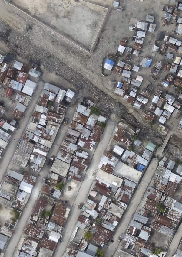
7

                                                                   Interest within the humanitarian community in functions that
                                                                   would allow the assessment and monitoring of large areas
                      Executive summary                            is balanced by concerns about perceptions. These applica-
                                                                   tions would require mid- to large-sized drones, which are
This in-depth investigation of the use of drones in humani-        often associated with military uses. The protection of peo-
tarian crises is the first of its kind to determine if, how, and   ple’s privacy is a separate concern related to monitoring,
under what circumstances drones can add value to human-            regardless of the size of the drone.
itarian operations in disaster areas. The most promising
uses of drones include:                                            Interest is building in the use of drones to assist in search
                                                                   and rescue, particularly when drones can be equipped with
• Mapping                                                          infrared or other specialized cameras. In the United King-
• Delivering lightweight essential items to remote or hard-        dom, the use of drones by fire-fighters is catching on. The
  to-access locations                                              initial results are promising, but this application is still ex-
• Supporting damage assessments                                    perimental with too few concrete examples from which to
• Increasing situational awareness                                 draw general conclusions.
• Monitoring changes
                                                                   In many situations, drone deployments can deliver a better
Mapping is the most evolved form of drone use in the hu-           return on investment than satellite images or aerial photog-
manitarian sector today. The technology is mature and              raphy from helicopters or planes. This is particularly true
skilled users can quickly produce information products             when detailed imagery of localized events is needed and in
that are of immediate use for humanitarian programmes.             cases where imagery has to be taken repeatedly.
Lightweight, consumer-friendly designs and automated
workflows make the use of drones for mapping a possibility         As drones are becoming easier to use, the main challenges
even for non-technical users. Mapping drones have shown            are shifting from flying the drones to processing, analysing
their greatest potential during the recovery phase after a         and storing the data that the drones capture. This requires
disaster, or for disaster risk reduction work.                     capacity-building within humanitarian organizations or co-
                                                                   operation agreements with NGOs or companies that pro-
The delivery of cargo with drones is a rapidly emerging            vide these services. Presently, humanitarian organizations
field that may offer the option to transport small items with      are choosing to work with service providers or in partner-
high frequency, thus complementing traditional means.              ship with other non-profit actors or local communities that
Most cargo drone models under development are still                have an active field capacity for drone deployments.
prototypes, and pilot projects are currently limited to light-
weight, high-value goods.                                          Drones frequently arrive too late to be useful in the immedi-
                                                                   ate aftermath of a disaster. Organizations can address this
The use of drones in monitoring and in the delivery of re-         issue by building local or regional capacity and integrating
al-time information remains controversial, and the humani-         drones into their emergency response toolkits.
tarian community is taking a cautious look at the prospects.
Small drones have streamed live video mostly in tactical           Inadequate regulations can be a substantial hindrance to
situations to provide an understanding about potential             deploying drones in crises. In many countries, regulations
road blockages or to quickly assess structures and infra-          do not exist and where they do exist, they typically do not
structure.                                                         include provisions for emergencies.
8

                            1.
© Mark Iliffe/CC BY-NC-SA
9

Introduction
10                                                                                                            INTRODUCTION

Drones are rapidly emerging as a potentially useful tool           • Conducting a survey on perceptions to gain an under-
for addressing the needs of people in humanitarian cri-              standing of the perception and the level of experience
ses. As prices drop and the technology becomes easier to             on the use of drones by staff from organizations involved
use, many barriers to their use are disappearing. But does           with humanitarian aid and civil protection
that mean that it make sense to use a drone after an earth-        • Building the knowledge base by documenting past de-
quake, flood, storm or landslide? Or is a drone just another         ployments and deploying drones in collaboration with
toy that absorbs organizational resources?                           partner organizations
                                                                   • Organizing stakeholder sessions to share information
“Drones in Humanitarian Action” is the first in-depth in-            and discuss outstanding issues and ways forward for the
vestigation of the appropriateness of using drones in hu-            safe and appropriate integration of drones in humanitar-
manitarian crises, with an emphasis on natural disasters. It         ian work
summarizes the findings of more than a year of research,           • Researching the current regulations of 30 of the most
stakeholder consultations and field deployments.                     disaster-prone countries in the world

The concept of the use of drones is relatively new in main-        The project encompasses research, consultations, events,
stream discussions of humanitarian action, and is a high-pro-      and deployments documented and available at: http://
file albeit controversial component of the humanitarian in-        drones.fsd.ch. This guide is intended as an entry point to
novation agenda. Humanitarian drone use emerged initially          the collected materials, providing an overview of key find-
from the drone industry’s interest in acquiring legitimacy         ings, case studies and background information with the aim
and moral capital, but the focus has since shifted to how          of answering the following key questions:
drones can assist in humanitarian action. The applications
have broadened from an exclusive focus on monitoring               •   What are the uses for drones in humanitarian action?
capacities, and now include a host of small and medium             •   Do drones provide added value to humanitarians?
drones equipped with thermal cameras and listening devic-          •   What is the applicable drone technology?
es and a range of cargo capacities.                                •   How difficult is it to make use of drones in humanitarian
                                                                       action?
Drones have become part of the broader discussions on
humanitarian technology and innovation, on remote man-             While this guide aims to shed light on the most effective
agement and on the relationship between humanitarian               uses of drones in humanitarian action with a view to im-
action and international peacekeeping. In response to the          proving the efficiency and quality of humanitarian aid, a
unprecedented management challenges due to the fre-                secondary aim is to demystify the technology and to make
quency and scale of humanitarian emergencies, the 2016             it more understandable and accessible to a general hu-
Agenda for Humanity of the United Nations Secretary Gen-           manitarian audience. The guide offers a broad overview of
eral states that to deliver collective outcomes, the human-        the current technology and potential future trends, and dis-
itarian sector must promote a strong focus on innovation.1         cusses issues that may arise with the use of the technology.
Hopes are high that drones will improve humanitarians’ ca-
pacity to assess needs, to monitor changes on the ground           The insights provided in this document come from 14
and even to deliver relief items. At the same time, critics        months of stakeholder consultations, primary and second-
voice their scepticism regarding the actual usefulness of          ary research and fieldwork. Overall, representatives from
drones in humanitarian settings.                                   42 humanitarian organizations including United Nations
                                                                   agencies were involved in the process. To the extent that
This project has made a systematic effort to understand            it reveals any particular world view, this document is based
if, how, and in what circumstances the use of drones can           on the conviction that drones, regardless of their origin, de-
deliver added value to humanitarian work in disaster ar-           serve consideration for humanitarian use when and if their
eas. While the use of drones is proliferating, this is the first   use can support humanitarian objectives. In the context of
undertaking of its kind to consolidate existing knowledge          the rapidly developing technology, the project team hopes
regarding humanitarian applications and to test, promote,          that this document can influence the positive evolution of
and share information about the appropriate use and best           the use of drones to improve the quality and efficiency of
practices within the humanitarian community. Such an evi-          humanitarian aid.
dence-based approach is key for the successful and ethical
integration of drones into humanitarian work. This initiative
includes the following elements:

1.   Agenda for Humanity - Annex to the Report of the Secre-
     tary-General for the World Humanitarian Summit
11
Figure 1 Drones in humanitarian action case studies
Fire and
rescue services
Greater Spatial
Manchester fire modeling of
and rescue displaced
service landmines
Belgian Royal Disaster risk
#12 Military reduction
Academy
FSD
#4 Earthquake
damage
Search
Hurricane and rescue
#11 #15 analysis
damage UAViators
analysis Trimodex Hurricane
Post-
damage
earthquake IOM #3 analysis
census
IOM Medair
#6
#7
#8 Camp #5
Flood Medical
management mapping for
Post-earth- payload
quake road IOM disaster risk delivery
damage mapping reduction #9
Real-time Médecins Sans
World Bank and information after
UAVIATORS #13 Typhoon Haiyan
Frontières
Humanitarian #2
#1 OpenStreetMap
#14 Team
Team Rubicon and
Building Palantir)
damage
assesment #16
GlobalMedic #10
Flood risk
mapping Disaster
FSD damage
assessments
World Bank
Mapping
Search & Rescue
Monitoring
Delivery
Regulating the use of drones
Those seeking authorization for the use of drones in humanitarian contexts face uncertainty in the regulatory envi-
ronment at this time. Many countries still lack a clear regulatory framework for drones, or, in many places, their use
is regulated to the extent that requirements are nearly impossible to fulfil for humanitarian actors in urgent humani-
tarian contexts. Governments around the world are currently working on creating and adapting legislation to ensure
both safety and development, and the regulatory landscape is rapidly evolving. A coalition of non-profit actors and
researchers is providing regulatory updates at: www.droneregulations.info.12 INTRODUCTION
This guide can assist humanitarian organizations and do-
nors in determining when and how drones can support
aid workers in delivering assistance, and in understanding
where their use clearly adds value; help decision makers
decide whether or not to use drones; and provide links to
additional resources.
This guide can also assist regulators and governments to
understand humanitarian uses for drones, and encourage
them to regulate the various drone types and applications
in a way that facilitates the safe and responsible use of the
technology. Similarly, this guide can help companies and
manufacturers gain a better understanding of humanitarian
needs and applications for the technology so that they may
better support and advise non-technical humanitarian aid
professionals.
Information presented in this publication is largely drawn
from materials produced as part of this initiative. The follow-
ing materials are available at drones.fsd.ch:
• Drones in Humanitarian Action – A survey on percep-
tions and applications
• Cargo Drones in Humanitarian Contexts: Meeting summary
• Mapping Drones in Humanitarian Action: Meeting summary
• Case Studies
1. Flood mapping for disaster risk reduction: Obtaining
high-resolution imagery to map and model flood risks
in Dar es Salaam
2. Using drones for medical payload delivery in Papua
New Guinea
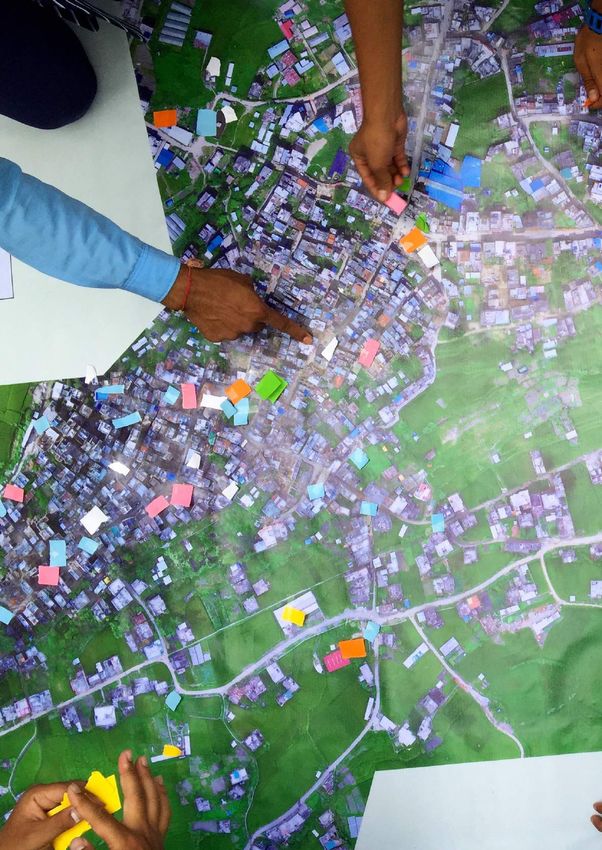
3. Small-scale mapping with consumer drones in Nepal
4. Deploying drones for spatial modeling of displaced
landmines after floods in Bosnia Herzegovina
5. Testing the utility of mapping drones for early recov-
ery in the Philippines
6. Mapping rapid damage assessments of Tabarre and
surrounding communities in Haiti following Hurricane
Sandy
7. Using high-resolution imagery to support the
post-earthquake census in Port-au-Prince, Haiti
8. High-resolution UAV imagery for camp management
in Haiti
9. Using drone imagery for real-time information after
Typhoon Haiyan in the Philippines
10. Using drones for disaster damage assessments in
Vanuatu
11. Simulation: using drones to support search and rescue
12. Using drones in fire and rescue services in the United
Kingdom
13. Using drones to inspect post-earthquake road dam-
age in Ecuador
14. Using drones to create maps and assess building
damage in Ecuador
15. Disaster risk reduction in Tajikistan
16. Flood risk mapping in Malawi13 Terminology The most common terms for drones are Unmanned Aerial Vehicle or UAV and Unmanned Aircraft Systems or UAS. The European Union uses the term Remotely Piloted Aircraft Systems or RPAS – a more formal term frequently used by international and national aviation agencies such as the International Civil Aviation Organization. For the sake of simplicity this publication uses the term “drone”.
14

     2.
15
Technology
and actors
© Werobotics16 TECHNOLOGY AND ACTORS
To date, the drones used in humanitarian efforts have been military or state actors. As the civilian drone market devel-
small or mini-sized devices that weight a few kilograms or ops, however, increased accessibility for larger craft may
less. These models are relatively easy to handle but are lim- be expected in the future.
ited in flight range and time. Humanitarian use has evolved
closely with the consumer and civilian market. Models man- The technology and operationalization of drones for cargo
ufactured for this market are developed with ease of use delivery is still nascent in both commercial and humanitar-
and safety in mind and can often be operated with minimal ian applications but the field is rapidly advancing. Given
training. These factors have made the technology accessi- the rapidly developing market and technology – the global
ble to civilians and to humanitarian actors alike. Contrary commercial drone market size was valued at approximately
to perceptions, long-range aircraft-sized drones have rarely €450 million in 2014 and is expected to grow to €1.8 billion
been used for humanitarian purposes. These larger drones by 2022 – technology, cost, applications and accessibility
require similarly larger budgets as well as increased coor- of drones are expected to continue to develop at a high
dination and specialized staff, and are typically operated by rate in the coming years.
Figure 2 Examples of drone models used in humanitarian action
Zip
by Zipline
Fixed-wing
Used for cargo delivery
Tron
by Quantum Systems
Hybrid fixed-wing and multi-rotor
ARF OktoXL 6S12
Used for cargo delivery
by MikroKopter
Vayu €60 000*
Multi-rotor
Hybrid fixed wing and
Used for mapping
multi-rotor
€6 500*
Used for cargo delivery Huggin X1
€12 000* by Sky-Watch
Multi-rotor
Used for live video feed
€40 000*
Matternet ONE
by Matternet
Multi-rotor
Used for cargo delivery
Phantom
by DJI
Cumulus 1
Mult-irotor
by Danoffice IT
Used for mapping
Fixed wing
€500-1 500 *
Used for mapping
€10 000*
MD4-1000
by Microdrones
Multi-rotor eBee
Used for live video feed by SenseFly
€42 000* Fixed wing
Used for mapping
€20 000*
*Estimated commercial retail price17
2.1. 2.1.2. Multi-rotor drones
Drone types
A wide variety of drones are already being used for hu-
manitarian purposes and more applications are expected
to emerge. Currently, the areas that have been explored
the most for practical applications within the humanitarian
context are mapping and monitoring. The choice for a par-
ticular drone platform and deployment strategy is guided
by application type, environmental conditions, organiza-
tional needs and associated costs, among other consid-
erations. (See Table 1 in the annex for a summary of orga-
nizations, applications and drones deployed in the past.)
2.1.1. Fixed-wing drones Multi-rotor drones are typically used for shorter flight times
and shorter distances to record pictures or to transport light
cargo. The most widely used multi-rotor drones have four
propellers, which is why they are often called quad-cop-
ters. But models with one rotor (helicopter) or with as many
as eight rotors (octo-copters) exist as well. Their main ad-
vantage is that they take off and land vertically thus do not
require much space, and improved controls and software
enable automatic stabilization and steering by remote con-
trol or autopilot. The trade-off, however, is that flight times
are severely shortened: many small consumer drones have
a battery life of only about 10 minutes. Models that can fly
longer are significantly more expensive.
Fixed-wing drones have a two-wing design, and are typical-
ly used to cover longer distances and carry heavier loads.
Fixed-wing drones are often preferred for larger mapping
projects or for projects that require the transportation of
2.1.3. Hybrid drones
cargo over longer distances. They can operate in up to 50
km/hour winds and can typically stay in the air between
30 minutes and several hours, depending on the model.
Most fixed wing drones fly on autopilot, following predeter-
mined flight paths that are uploaded ahead of the flight. A
pilot on the ground merely monitors the flight progress and
makes adjustments when necessary. A major drawback of
fixed wing drones is that they usually require a strip of open
space for landing and take-off. Such spaces may be difficult
to find in mountainous, densely forested or densely built
environments.
Hybrid drones are relatively new and are equipped with
both wings and rotors. This hybrid configuration allows for
vertical take-off and landing, and provides the drones with
the ability to fly horizontally like fixed-wing drones. This
means that they can cover far longer distances and carry
heavier cargo than multi-rotor drones. These hybrid drones
look promising for cargo delivery where the combination
of long flight time and vertical take-off and landing are im-
portant features.18 TECHNOLOGY AND ACTORS
2.2. 2.3.
Partnerships Humanitarian aid workers
Only a few organizations that have used drones in human- on the use of drones
itarian efforts have developed their own internal capacity.
Instead, most humanitarian organizations are choosing to To establish a baseline for perceptions of drone prolifer-
work with service providers or in partnership with other ation and the degree of acceptance in the humanitarian
non-profit actors or local communities that have an active sector, the authors of this study conducted a comprehen-
field capacity for drone deployments. Often, agencies from sive survey of how humanitarian professionals view drones.
other fields such as geology, forestry and construction Close to 200 disaster responders working in 61 different
have drone capacities for applications that can easily be countries took part.
adapted for humanitarian missions.
The results show that a substantial majority of respondents
In addition, technology companies may also provide pro (60 per cent) believe that drones can have a positive impact
bono services for certain projects. Companies in the early in disaster response operations, while less than a quarter
stages of service development often provide their technol- (22 per cent) see their use negatively – at least when used
ogy free of charge to humanitarian organizations so they following natural disasters. The opinions shift significantly
can test their prototypes and perfect their technology in on the use of drones in conflict zones. Here, humanitari-
field conditions and in countries where regulations are an workers are sharply split: while 40 per cent stated that
more favourable. In addition, companies might seek asso- drones should never be used by humanitarian organiza-
ciation with humanitarian organizations to profile their ser- tions in conflict settings, 41 per cent said they would con-
vices and distinguish themselves from their competitors. In sider using drones even during armed conflicts.
this case it is advisable to have clear guidelines in place to
ensure that actual use cases are tested and that resulting The survey also shows that much more needs to be done
information or data is shared equitably without emphasiz- within the humanitarian sector to build knowledge about
ing or extolling one company over another. Many organi- the advantages, disadvantages, capabilities and limitations
zations and agencies have developed internal guidelines of drones. The vast majority (87 per cent) of respondents
on how to handle pilot projects with new technologies. In said that they did not have first-hand knowledge of using
addition, UAViators has developed a comprehensive code drones. Many of them explained that they were looking for
of conduct that can serve as a resource to any organization guidance and needed experience to make the best use of
that is beginning to explore the use of drones. the technology.
Overall, there was confidence among two thirds of respon-
dents that drones have a large potential to strengthen
humanitarian work and especially that drones can greatly
enhance the speed and quality of localized needs assess-
ments.
The full report “Drones in Humanitarian Action – A survey on
perceptions and applications” is available at drones.fsd.ch.19 2.4. Applications The following chapters discuss the four most common ap- plications: mapping, search and rescue, monitoring, and cargo delivery. Drones have been used to speed up or in- crease the quality of localized damage assessments, plan- ning for disaster risk reduction, planning of humanitarian interventions, improving camps and shelter units and in the delivery of small essential items. Drones also show great potential in tactical settings such as supporting the work of search and rescue teams and field teams. Other functions, such as the provision of Internet and the use of drone-derived footage for public relations are not treated in detail here. Large technology companies such as Facebook and Google are currently exploring the provision of Internet and connectivity, and the service will presum- ably become available to humanitarians once the technolo- gy reaches civilian markets.1, 2 1 Project Loon. Google X. Retrieved at https://www.solveforx. com/loon/ 2 The technology behind Aquila. Zuckerberg, M. 21 July 2016. Retrieved at https://www.facebook.com/notes/mark-zucker- berg/the-technology-behind-aquila/10153916136506634/
20

What do humanitarian professionals think about
the use of drones in humanitarian crises?
We asked 194 humanitarian aid professionals who work in 61 different countries, what they think about the use of drones.
The first of its kind, this survey measures perceptions about the use of drones in humanitarian action.

                          “Drones allow
                    for a bird’s-eye view;
               assessments can be done very
                                                            In general, how do you view the use
            rapidly [...] and it would enable more
          systematic assessment and monitoring.”
                                                            of drones for humanitarian work?
        “We already use a lot of GIS and technology
        approaches and support the United Nations
     Office for the Coordination of Humanitarian Affairs                                      “[Drones
                 in information management.”                                           are] too distant from
                                                                                      people and inhumane.”
       “Access is key and sometimes impossible with
           traditional transportation resources.”                                “[... the use of drones] will first and
                                                                              foremost contribute to the current trend
        “A tool that can easily be used to assess and
         get a clear situation in areas that cannot be
            accessed in the shortest time without
                                                             60%            to remove actors from field operations and
                                                                             beneficiaries, which leads to deterioration
                                                             Favorable                   of the quality of aid [...]”
                   involving many people.”
                                                                             “I have observed the use of drones and
                                                                              think they can only have a very limited
                                                                                     use in humanitarian aid.”

                                                             18%
                                                                                 “How do we insure the difference
                   “The result of the                                              between a military instrument
               drone work must produce                                                 and a civilian aid?”
            a good added value for my job.
                                                              Neutral
               Pictures are not enough.”
        “Proponents of UAVs need to be very
        careful about showing impact of their
                                                            22%
                                                            Unfavorable                    “Whether we like
              use and mitigating risks.”
                                                                                       it or not, UAVs are con-
      “Usefulness of the technology depends on                                     fused with weaponized drones
     the type of operation, expertise, experience                                 and are perceived by the general
       and area. [Drones] must be used together                               public as related to military operations
        with other technologies that can provide                            and/or intelligence gathering. In countries
        a complete picture of a situation. Rapid                            and contexts with conflict environment, it
           development of drone technology                                is illusory to imagine that the general public,
              could increase the number of                                 authorities and the armed actors will make
                      applications.”                                       a distinction between good ‘humanitarian/
                                                                            civilian’ drones and bad ‘military’ drones.
                                                                               The reputational risk on humanitarian
                                                                                organizations would be too high and
                                                                                   could jeopardize the operation-
                                                                                       al humanitarian space.”
What drone use would be of most interest to you?

                                                                                                                        Other
                                                                                                    Public
     Mapping                   Monitoring                  Search &           Delivery           information          14%
     89%                        68%
                                                            Rescue
                                                                              36% 30%
                                                           49%
21
Please evaluate the following statements concerning humanitarian
applications of drones
“Drone
technology
30% “Drones 42% “Local
populations
57%
Agree should be a Agree Agree
is still too limited standard element feel threatened
for humanitarian of deployment by by the use
use.” humanitarians” of drones”
25%
Neutral
21%
Neutral
45% 19%
Disagree
37% Neutral
Disagree
40% 24%
67% Disagree 71%
Agree Agree Agree
“Drones “Drones can
“Drones have greatly enhance
should never a large potential the speed and
be employed
in conflict 19% to strengthen
humanitarian
quality of localized
settings” Neutral needs assess-
work” ments”
41% 14% 11%
Disagree Neutral Neutral
19% 18%
Disagree Disagree
In order for drones to be useful in humanitarian action...
Organizations need more experience.
70%
Clear guidance and rules need to be established.
86%
Coordination should be improved
and institutionalized. 55%
Dedicated service providers should be
available to work with humanitarians. 61%
Other
33%22
3.
© Mapbox ©OpenStreetMap23 Mapping
24                                                                                                                    MAPPING

Mapping is the most common and most popular drone ap-             Humanitarians and civil protection actors began using
plication to date. Lightweight, consumer-friendly designs         drones for mapping and aerial imagery within the past de-
and automated workflows make this technology accessible           cade. In Haiti, the International Organization for Migration
even to non-technical users. Mapping drones have been             (IOM) created maps to prepare the census1 and manage
used to make accurate, two-dimensional maps, elevation            IDP camps2 after the 2010 earthquake. Since then, IOM has
models, and 3D models of terrain. The use of drones for           institutionalized the use of drones for camp management
mapping has shown significant advantages compared to              in Haiti. The World Bank together with the Humanitarian
other methods in the following cases:                             OpenStreetMap (OSM) community followed closely behind
                                                                  in Tanzania, mapping informal settlements to increase resil-
• Capturing aerial imagery and making base maps of rela-          ience to seasonal floods.3
  tively small areas (
25
3.1. For more detailed maps, the drone has to be flown closer
to the ground or it needs to be equipped with a higher-res-
Drone-mapping workflow olution camera. For maps with less detail, the drone flies at
higher altitudes so that each picture covers a wider area.
In most cases, using drones to create maps entails retrofit- Typical altitudes for a mapping drone may range between
ting regular (point-and-shoot) cameras and mounting them 80 and 300 metres, and in some instances even higher.
on a small drone that then flies with the help of an autopilot
in predefined patterns, taking pictures in certain intervals.
The pilot merely launches the drone and monitors the flight
progress from a laptop or tablet as all other functions are
fully automated.
Figure 4 Drone-mapping workflow
A drone takes a series of images along After downloading the images from The resulting geometrically correct
its pre-programmed flight path above the drone camera, mapping software aerial image is called an ‘ortho-
the mapping area. matches and stitches them together. mosaic’.
Example of an ortho-mosaic of Mponda in Malawi.26 MAPPING
3.1.1. Mapping area size and image 3.1.2. Outputs
resolution
The individual pictures taken from the air are “stitched”
One or several drone flights are needed to cover a desig- together to create one large picture, also known as an
nated mapping area. The larger the area and the higher the ortho-mosaic. This is a series of overlapping aerial photo-
resolution required, the more time is needed for data collec- graphs that have been geometrically corrected (ortho-rec-
tion and processing. Larger areas or higher resolutions also tified) to give them a uniform scale. This process removes
increase the amount of data that is produced. This in turn in- perspective distortion from the aerial photos, which can be
creases the need for storage capacity, processing capacity used without further processing as base maps or can be fur-
and processing time, all of which can increase costs. ther processed into other maps and information products.
Specialists in geographic information systems (GIS) can
Spatial resolution is measured in Ground Sample Distance use the ortho-mosaics to produce a variety of advanced
(GSD) and refers to the distance between pixel centres information products in processes that are similar to those
measured on the ground. In an image with a one-metre that would be applied to satellite images. The Humanitarian
GSD, for example, adjacent pixels image locations are one OpenStreetMap community, in particular, has made use of
metre apart on the ground. ortho-mosaics derived from images captured by drones in
a number of projects around the world.
Drone images of Port-au-Prince,
Haiti, and the OpenStreetMap of
the same area.
One of the greatest advantages of this
mapping method with drones is the ability
to easily create 3D elevation models like
this one of Darjomj valley in Tajikistan.
A digital surface model (DSM) is a three-
dimensional representation of the earth’s surface.
It includes trees, buildings and any other objects.
A digital terrain model (DTM) shows the earth’s
surface, but not the objects on it.27
Figure 5 Mapping products
Ortho-mosaic Map
3-Dimensional model
Digital surface model Digital terrain model28 MAPPING
Drones can employ a number of different types of sensors sensor. Thermal maps are used for detecting structural
besides cameras that operate in the visible light spectrum. damage to roads or identifying the source of a ground-
Near-infrared sensors are used for Normalized Difference water discharge. In search and rescue, live video feeds of
Vegetation Index maps, which indicate whether an area thermal images can be used to find people in inaccessible
has green vegetation or not, based on the amount of in- areas or at night.
frared light reflected by living plants. Such maps are most
often used in the agricultural sector to monitor plant growth The output from a drone flight is only the initial data for a
productivity, but this information can also be used for other project and is tailored to a specific technical need. A hydrol-
purposes such as detecting changes in the ground cover. ogist, geologist, site planner or GIS specialist makes the
For thermal imaging, a drone is equipped with an infrared output operationally useful as a tool for decision makers.
Field experience
Flood mapping for disaster risk reduction
Type of system eBee Fixed Wing Mapping Microdrone
Deploying Agency World Bank and Humanitarian OpenStreetMap Team
Piloting Agency Drone Adventures
Dates of Deployment February and March 2015
With an estimated population of 5 million and an annual growth rate of 8 per cent, Dar es Salaam, Tanzania, is Af-
rica’s fastest growing city. Over 70 per cent of the people live in informal, unplanned settlements with inadequate
infrastructure. In addition, heavy rainfalls twice a year result in significant flood risks. The creation of an updated city
map for Dar es Salaam was beneficial because it makes available a map that actually reflects the city, rather than
merely showing official roads and boundaries. A coalition comprising local authorities, the Tanzania Commission for
Science and Technology, two universities and the Buni Innovation Hub spearheaded a project to produce a detailed
map of the city in early 2015. The map was developed based on aerial imagery captured by eBee drones that were
piloted by the volunteer organization, Drone Adventures. The majority of the data was obtained during two weeks
of mapping, including 20 000 optical images covering an area of 88 km2 with an average resolution of about 5 cm.
By the end of the year, and with additional support by the Humanitarian OpenStreetMap Team, the aerial imagery
data had been converted into a complete map of the city, with houses and other infrastructure mapped at unprece-
dentedly detailed levels. The detailed map serves to support urban planning with a particular emphasis on disaster
risk reduction and preparedness for natural disasters such as floods as well as health emergencies such as cholera.
Figure 6 Comparison between the same part of Dar es Salam
in Google maps (left) and OpenStreetMap (right)
Source: http://drones.fsd.ch/29
3.2. delivery of these images might take between a half a day
and four days. Alternatively, customers can commission
Drones versus the alternatives new images to be taken once the satellite passes the area
in question and weather conditions are suitable. Prices for
Satellites, airplanes and helicopters are the three most com- this service range between €1 400 and €6 000 for min-
monly used alternatives to drones in aerial mapping and as- imum areas of 25 or 100 km². Delivery time depends on
sessments. These are not considered opposing methods; satellite availability and cloud cover at the imaging site. For
rather these tools are complementary and, at times, the large-scale disasters, the international Charter on Space
collected data overlap to reinforce maps and strengthen and Major Disasters may be activated and free access to
the quality of information. After floods in Bosnia, for exam- satellite-derived information products are then made avail-
ple, drones were shown to be more efficient and suitable able to support disaster response.
than available helicopters or small planes when small areas
of moving minefields needed to be mapped, but for larger On the other hand, most mapping drones can cover up to
areas, helicopters were deployed.1 3 km² in one day or 10 km² in one week of data collection
and processing. Their image resolution ranges from 3.5-8.0
Satellite imagery is another common solution for base cm. It is also becoming more common for single operators
maps. In general, satellite imagery has lower resolution but to fly multiple drones at the same time to cover larger areas
covers larger areas than mapping drones. When ultra-high in less time. The cost for drone images depends largely on
resolutions are not necessary, satellites may provide imag- the production conditions, and cannot be estimated in a
ery at a much lower price. Resolutions range from 30 cm generalized manner.
to 30 m, and images covers a minimal area of 25-100 km².
Service providers offer the option of purchasing existing In addition to the higher resolution, drones are able to cap-
high-resolution archive imagery that can be several days ture images from below clouds, a capability that provides
or weeks old. They cost around €250-400 for 25 km² and additional flexibility and faster response time compared to
satellites. For example, in Haiti following Hurricane Sandy,
cloud cover prevented satellites from acquiring imagery,
1 Deploying drones for spatial modeling of displaced land- while drones were able to fly. Heavy cloud cover is often
mines after floods in Bosnia Herzegovina. Case Study. FSD. present for several days following extreme weather events
2016 http://drones.fsd.ch/en/homepage/ such as typhoons, cyclones and hurricanes.
Figure 7 High-resolution drone images and lower-resolution satellite images
Drone imagery Satellite imagery
Imagery Data Swinglet CAM Drone Imagery Data DigitalGlobe WorldView-02
Imagery Dates 10 February 2012 Imagery Dates 8 February 2012
Resolution 5 cm Resolution 50 cm
Copyright UNITAR/UNOSAT 2012 Copyright 2012 DigitalGlobe
Analysis UNITAR/UNOSAT Analysis UNITAR/UNOSAT30 MAPPING
3.3. 3.4.
Data processing and analysis Cost factors
As the technology advances and drones become easier While the rapidly evolving market and the specific condi-
to operate, more data are collected. As a result, data pro- tions of each case will determine the costs of drone deploy-
cessing and analysis require more attention – especially ments, a number of factors typically influence the budgets:
in large-scale projects. The data collected for the Dar es
Salaam flood risk map, for example, had to be processed • Preparation – applying for licenses, negotiations with
externally, and took six weeks with high-speed processors. ministries or competent authorities, and engagement
Mapping an area of 88 km2 with an average resolution of with local communities
5 cm created a data set containing 20 000 optical imag- • Data collection – preparing flight plans, piloting and
es. After processing, the resulting files added up to 700 equipment maintenance
gigabytes, and the data could only be moved by physical • Data processing – uploading, processing, and render-
transfer on a hard disk. Clearly, requirements such as these ing of the collected data to create ortho-mosaics, base
make it challenging to operationalize the technology in a maps, and 3D models where access to power, Internet
crisis. On the other hand, in situations where information and processing platforms may be restricted
is required for smaller areas, in lower resolution, and pro- • Data analysis – obtaining actionable information from
cessed with less elaboration – aerial photography instead data analysed by specialists
of GIS-compatible maps, for example – results can be
achieved in a fraction of the time. The following figure com-
pares mapping products from the previously mentioned
case studies with their respective data collection and pro-
cessing times to further illustrate how mapping dimensions
influence related efforts:
The successful operation of mapping drones requires
clearly defined project needs, an assessment of available
capacities and the consideration of safety, situational suit-
ability and external factors such as weather. These steps
help humanitarians confirm that drones are indeed the best
tools as compared to the alternatives.
Field experience
Small-scale mapping with consumer drones in Nepal
Type of system DJI Phantom 3 Advanced with Pix4Dcapture mobile app
Deploying Agency UAViators
Piloting Agency DJI
Dates of Deployment September 2015
After the magnitude 7.8 earthquake in Nepal in 2015, the lack of high-resolution and up-to-date imagery became
acute as communities and non-governmental organizations worked with images of insufficient quality. UAViators
and their technology partners became involved with the aims of providing training sessions and field missions using
affordable consumer drones and demonstrating the potential of drones in humanitarian missions. The team of pilots
and students took aerial imagery of one of the hardest hit communities in Katmandu. Mapping the community that
had an area of 1.5 km² took nearly two days of flying six consumer-type drones (DJI Phantoms) for a resolution of 3.4
cm. For comparison: it takes about 1-2 hours to achieve the same results with a single professional mapping drone.
The imagery was then processed overnight directly by Pix4D staff on laptops. The resulting ortho-mosaics were then
printed on simple roll-up posters that were then given to the local Community Disaster Management Committee who
worked directly with the community to use these maps for local planning.
Source: http://drones.fsd.ch/31
Figure 8 Data processing time and data size examples
Mapping 88 km2
Image resolution 5 cm
Data volume 700 GB
Processing time 6 weeks
Flight time Unknown
Products Digital street map, District drainage system map,
3D surface model
Case study: Flood mapping for disaster risk reduction in
Tanzania
Mapping 1.5 km2
Image resolution 3.4 cm
Data volume 1-2 GB
Processing time 2 days overnight
Flight time Unknown
Products Ortho-rectified aerial photograph
Case study: Post earthquake mapping in Nepal
Mapping 23 km2
Image resolution 15.8 cm
Data volume 37 GB
Processing time 2 weeks
Flight time 11.6 hours
Products Ortho-rectified aerial photograph, DSM
Case study: Disaster risk reduction Tajikistan
Mapping 2 km2
Image resolution 4 cm
Data volume 3 GB
Processing time few hours
Flight time 2 hours
Products Ortho-rectified aerial photograph, 3D surface model
Case study: Hurricane flood damage analysis Haiti32 MAPPING
3.5. The most successful uses of drones for mapping in human-
itarian emergency contexts usually involve an organization
Emergency response mapping that already possesses the necessary equipment, autho-
rization to fly and skilled human resources at the time of
While it is highly likely that drones have a place in the hu- the disaster, as in Haiti in 2012. Until now, only a few or-
manitarian response toolkit, they are not yet systemati- ganizations have invested in such in-house capacities, and
cally used during the rescue and emergency relief phase the majority work with external service providers for drone
immediately following an emergency, that is, within 48-72 deployments.
hours1 of the disaster striking. There are, however, some
examples: In the 2012 response to Hurricane Sandy in Hai- Studies show that it takes an average of 6.5 days3 for a drone
ti mapping drones were successfully used to assess flood to arrive at the scene of a disaster, which is well beyond the
damage more rapidly than could have been done with sat- critical 72-hour window. In most developing countries lo-
ellite imagery.2 The success of this deployment is partly at- cal capacity for drone mapping is still limited but once this
tributable to Haiti being often hit by weather events and business sector develops, it is likely that organizations can
other disasters, and so the humanitarian community (IOM reduce response times by partnering with local service pro-
and OSM) consisted of seasoned experts in mobilizing an viders instead of bringing in drone operators from abroad,
in-country emergency response and in deploying existing or by having in place streamlined procedures for authoriza-
drone support. Similar efforts to streamline damage as- tions. This is both economical for organizations and bene-
sessments using drones, among other tools, are underway ficial for local development. At the same time, operational
in the Pacific Islands. efficiency increases through readily available local knowl-
edge, experience and existing networks and infrastructure.
1 OCHA. Unmanned Aerial Vehicles in Humanitarian Re- 3 Disaster Robotics. The MIT Press. Robin R. Murphy. 2014
sponse. 2014
2 Tabarre damage assessment
Field experience
Using drones for disaster damage assessments in Vanuatu
Type of system Indago Multi-copter Microdrones by Lockheed Martin, 960L by Allign, Phantom Vision+ by DJI
and fixed-wing model UX-5 by Trimble
Deploying Agency World Bank with UAViators
Piloting Agency Heliwest, Australia, and X-Craft, New Zealand
Dates of Deployment 28 March to 12 April 2015
Cyclone Pam struck Vanuatu and destroyed thousands of homes, schools and other buildings. A group of drone
pilots from the Humanitarian UAV Network carried out aerial surveys as the first operational project related to the
World Bank UAVs for Resilience programme. The drone team formulated standard operating procedures and coor-
dination mechanisms, and carried out about 200 flights. Logistical and communication challenges, a lack of clarity
about specific data requirements and the lack of a standardized file format limited the success of the project, but
the drones mapped areas more quickly than any other available method, and the World Bank notes that extensive
learning and insights were gained through the drone mission.
According to the World Bank, the damage assessment teams used the drone imagery to verify the ground data
and to estimate the costs of the damage. The Bank sees drones as an effective, low-cost means to carry out rapid
post-disaster damage assessments immediately following an event.
Source: http://drones.fsd.ch33
3.6.
The way forward on mapping
Mapping drones have shown their greatest potential during
the recovery phase after a disaster, or for disaster risk re-
duction work. These findings do not preclude the use of
drones during an emergency, but this use usually takes a
larger degree of preparedness and coordination, which
many actors and processes are now starting to address.
Decision makers in government and in humanitarian or-
ganizations are at times suspicious of the use of mapping
drones, a reluctance that may be due in part to the military
use of drones. The perception of the drones based on mil-
itary craft, however, overlooks the reality that many map-
ping drones weigh less than a kilogram and are the size of a
large bird. At the same time civilians are often already using
these technologies in the same or similar settings in which
humanitarians propose to deploy the technology.
Questions regarding the protection of privacy and the ethi-
cal collection and use of data have come up, especially since
many mapping projects take place in densely settled places
and capture high-resolution images. Only one study has been
conducted to date that has looked at the local perception on
the use of mapping drones: In Dar es Salaam,1 the nonprof-
it human development organization, FHI 360, found that by
and large, both “community witnesses and government offi-
cials were positive about the potential of [drone] technology
in Tanzania.” Nonetheless, the study on humanitarian percep-
tions indicates that the use of drones is still associated with
military uses.2 For this reason, it is all the more important to
be transparent and to fully inform the stakeholders about the
technology and the intended uses and outputs.
Currently, the main issues on the technical level are the
management and sharing of data, including the time it takes
to analyse the data. Practitioners should reinforce and help
develop an open data ecosystem that is available to all hu-
manitarian actors and a local mapping capacity similar to
OpenStreetMap in Haiti. As more information is collected,
more attention needs to be placed on storing and analys-
ing aerial data. The OpenAerialMap (OAM) project provides
the tools and an open service to store, search, and find im-
agery that attempts to address these issues. In addition,
the Pacific Drone Imagery Dashboard (PacDID) project,
spearheaded by the Humanitarian OpenStreetMap Team
(HOT), is developing the idea of applying the OAM concept
together with guidance for improving the workflows of di-
saster mapping in the Pacific Islands.
1 Eichleay M, Mercer S, Murashani J, Evens E. Using Un-
manned Aerial Vehicles for Development: Perspectives from
Citizens and Government Officials in Tanzania. FHI 360.
2016. Published on ICT works January 2016: http://www.
ictworks.org/wp-content/uploads/2016/02/UAV-public-per-
ceptions-tanzania.pdf
2 Drones in Humanitarian Action – A survey on perceptions and
applications. FSD. 2016. http://drones.fsd.ch/en/homepage/34
4.
© Aris Messinis/Matternet35 Cargo delivery
36                                                                                                         CARGO DELIVERY

The delivery of cargo with drones is a rapidly emerging          One of the largest growth sectors for cargo drones is devel-
field, but – unlike mapping drones – the technology has not      opment. One third of the world’s population lacks regular
matured to the degree that it is available as off-the-shelf      access to essential medicines. The causes include poor in-
gear. While most models under development are still pro-         frastructure in developing countries, complex logistics and
totypes, with the rapid developments in recent years and         lack of money. Poor “last mile” delivery logistics is the crit-
industry interest in this application, more advances in this     ical constraint preventing medical supplies from reaching
technology can be expected in the coming years. The hu-          these areas, and causes 40 per cent of vaccines supplied
manitarian sector will not be a primary driver for this tech-    to parts of the underdeveloped world to expire before they
nology, but there are other fields that can guide humani-        can be administered. Especially with regard to last mile
tarians in adapting the technology to emergency contexts.        delivery, the use of drones might help optimize the supply
                                                                 chain and increase efficiency in the humanitarian sector.
The rapid, reliable and cost-effective delivery of life-sav-
ing supplies to communities affected by major disasters is       Because drones are flexible and deploy quickly (once the
a central element of humanitarian relief efforts. The suc-       appropriate infrastructure is provided), they can play an
cess or failure of a response hinges in large part on the        important role in last mile delivery. Health workers can
humanitarian supply chain as the “backbone of human-             contact suppliers with exact requirements based on actual
itarian operations and its functions are vital to reaching       demand. In return, the drones deliver exactly what is need-
beneficiary populations.”1 The transportation of this cargo,     ed with no supply guesswork required. Delivery can often
however, can be hampered by a number of factors. These           be carried out irrespective of ground conditions or infra-
include damaged or unreliable ground infrastructure, road        structure. Severe weather conditions still present important
blockages due to landslides and flooding, and the limited        challenges for most platforms but even with weather de-
availability of transport solutions, not to mention restricted   lays, drones may offer cost savings over traditional delivery
access due to security issues. Cargo delivery by manned          methods. Drones can provide more reliable and consistent
aircraft, while relatively expensive, is often the only other    deliveries, and multiple deliveries per day can improve the
option following major disasters. This in part explains why      responsiveness of the delivery system.
the humanitarian supply chain represents 60-80 per cent
of humanitarian expenditures.2 Drones may offer the option
of transporting smaller payloads across shorter distances
at high frequency, thus complementing traditional means.

1 http://www.logcluster.org/sites/default/files/gm_files/whs_
  humanitarian_supply_chain_paper_ final_160524.pdf
2 Peter Tatham, and S.J. Pettit, “Transforming humanitarian
  logistics: the journey to supply network management”,
  International Journal of Physical Distribution and Logistics
  Management, Vol. 40 No. 8/9 (2010), pp. 609-622.
You can also read