Engineering With Nature Geographic Project Mapping Tool (EWN ProMap)
←
→
Page content transcription
If your browser does not render page correctly, please read the page content below
ERDC TN-EWN-15-1
                                                                                               July 2015

                                       Engineering With Nature Geographic Project
                                                      Mapping Tool (EWN ProMap)
                                                                  By Thomas J. Fredette, Burton C. Suedel,
                                                                      Austin V. Davis, and Cynthia J. Banks

PURPOSE: This document summarizes the development, information content, and basic
operation of a geography-based mapping resource for projects that fit within the Engineering With
Nature (EWN) context (Bridges 2012). The purpose of the EWN Project Mapping Tool (EWN
ProMap) is to assist users in their search for case study information that can be valuable for
developing EWN ideas during the planning phase of projects. The development of EWN ProMap
was sponsored by the Dredging Operations and Environmental Research (DOER) Program.

BACKGROUND AND PROBLEM: Engineering With Nature is defined as the intentional
alignment of natural and engineering processes to efficiently and sustainably deliver economic,
environmental, and social benefits associated with water resource projects through collaborative
processes (Figure 1). Essential elements of EWN include: (1) using science and engineering to
produce operational efficiencies supporting sustainable delivery of project benefits; (2) using
natural processes to maximum benefit, thereby reducing demands on limited resources,
minimizing the environmental footprint of projects, and enhancing the quality of project benefits;
(3) broadening and extending the base of benefits provided by projects to include substantiated
economic, social, and environmental benefits; and (4) using science-based collaborative
processes to organize and focus interests, stakeholders, and partners to reduce social friction,
resistance, and project delays while producing more broadly acceptable projects (Bridges 2012).

The EWN concept is relatively new to many project planners such as biologists, engineers, and
project managers. One of the key hindrances to implementation of the EWN concept is
documentation of projects in terms of both project descriptions and information that documents
success (Fredette et al. 2011, Bridges 2012). The EWN ProMap tool is intended to make the
information for projects applying EWN principles more readily assessable. For example, the
EWN ProMap database provides numerous case studies for infrastructure projects such as
breakwaters, river engineering dikes, and seawalls that have provided benefits to support fish,
invertebrate, avian, and plant communities.

                          Approved for public release; distribution is unlimited.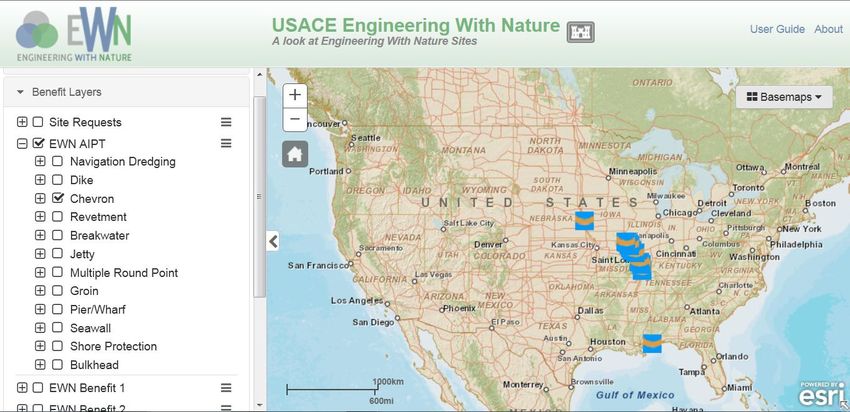
ERDC TN-EWN-15-1
July 2015

                            Figure 1. EWN promotes triple-win outcomes
                                      by providing the practical means for
                                      systematically integrating economic,
                                      environmental, and social benefits
                                      throughout project development.

DEVELOPMENT OF THE EWN PROMAP

Need for a Spatially Explicit Visualization Tool. The growth of internet-based Geographic
Information Systems (GIS), data visualization services, and the emergence of greater public use
of on-line map services has prompted many government agencies to adopt web-enabled GIS
(WebGIS) frameworks as a crucial tool for delivering essential information to users (Fu and Sun
2011). As GIS expanded into the online landscape, maps created by overlaying data from
multiple sources — such as restaurant locations, reviews, and street maps — became
increasingly common and rapidly evolved into the GeoWeb. The GeoWeb is the delivery of
spatially referenced information linked to non-spatial data through internet-based technologies to
enhance the map-based understanding of our world.

Genesis of EWN ProMap. Since the U.S. Army Corps of Engineers (USACE) is a
geographically distributed agency, it has actively embraced the GeoWeb and adopted Rich
Internet Application (RIA) technologies to convey the successes of the organization. EWN
ProMap, a product of the USACE Engineer Research Development Center, Environmental
Laboratory’s Geospatial Data and Analysis Facility (GDAF), is RIA built using JavaScript,
utilizing Esri’s ArcGIS Portal Application. The back-end data are supplied by Esri’s ArcGIS
server software and ProMap is made available to any user with internet access without
individuals needing an ArcGIS license. EWN ProMap involves deployment of background base-
map layers hosted by ArcGIS overlaid by a GDAF data layer containing positional and case-
study data for specific EWN projects (http://gis2.sam.usace.army.mil/applications/opj/v013/).

EWN ProMap Content and Capabilities. EWN ProMap includes more than 175 projects,
although this number will increase as new projects are identified or developed. Presently, most of
the projects in the database are in the United States with some representation in the rest of the
western hemisphere, particularly for reef module breakwaters in the Caribbean and Central
America regions. At the time this document was written, only five projects outside of the western
hemisphere were included.

                                                 2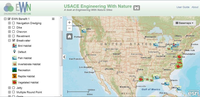
ERDC TN-EWN-15-1
July 2015
EWN ProMap contains a wide array of project types and project information for use as concept
starting points for new projects (Figure 2). Projects in ProMap can be displayed, ranging from the
global scale to the project scale (Figure 3). Projects can be displayed by the associated
infrastructure project type (AIPT) or the intended EWN benefits (EWNB1, EWNB2, EWNB3).
The map displayed by ProMap is generated by the user's selection on the left-side tool panel
(Figure 4).
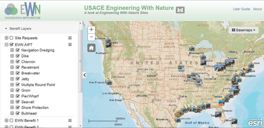
Figure 2. EWN ProMap overview. Icons represent project locations and type. ProMap has a tool panel, a
basemap selection tool, a user guide link, and an About page as part of the functionality.
Figure 3. An example of EWN ProMap zoomed to project scale. The project shown is a semi-submerged
reef breakwater constructed at Dauphin Island, AL, to provide shore protection and habitat for
fish and invertebrates. Each site icon can be clicked to open a pop-up box that provides more
detailed site information and relevant web links.
3
ERDC TN-EWN-15-1
July 2015

Figure 4. EWN ProMap site selection function displayed. Associated infrastructure project types (AIPT)
          shown. The tool panel also has a search box that can be used to look for sites by keyword.

The tool panel allows the user to filter the data based on different site types (Table 1) and by a
site-name search (Figure. 2). The user is able to view site attribute information by clicking on a
site icon in the graphics layer (Figure 3). The site icon pop-up bubble provides the functionality
necessary to deliver non-spatial information (e.g., site description, data files, and hyperlinks); the
pop-up can also display links to site images. When a site type or particular EWN benefit is
selected, the display will populate with all of the possible site candidate types on the map
(Figure 5). Thus, if a user is interested in ideas associated with breakwaters or sites that are
intended to provide fish habitat, they will be able to quickly narrow their search (Figure 6). The
interactive design of the tool panel is the key to the web-viewer’s experience.

Table 1. EWN ProMap site classifications used in the tool panel.
Classification
Acronym            Description                                Information Content
AIPT               Associated Infrastructure Project Type     Defines the type of water resource project
                                                              from which additional benefits are
                                                              provided (Beach, Dike, Breakwater,
                                                              Chevron, Pier, etc.)
EWNB1              Engineering With Nature Benefit 1          Defines the first EWN benefit intended by
                                                              project designers (Fish Habitat, Bird
                                                              Habitat, Recreation, Beach Nourishment,
                                                              etc.)
EWNB2              Engineering With Nature Benefit 2          Defines the second EWN benefit intended
                                                              by project designers
EWNB3              Engineering With Nature Benefit 3          Defines the third EWN benefit intended by
                                                              project designers

                                                   4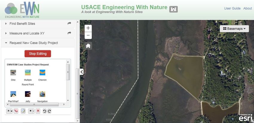
ERDC TN-EWN-15-1
                                                                                             July 2015

Figure 5. The tool panel used to filter sites by project type. The illustration shows the Chevron
          infrastructure type as being selected.

Figure 6. Display of EWN benefits by breakwater site type. Users can select any project type based on
          their interest.

The site types in the tool panel are the associated infrastructure project type (AIPT) and up to three
EWN benefits provided by a project (EWNB1, EWNB2, and EWNB3), as defined by the original
goals of the project. This information also often appears in the brief project descriptions (Figure 3).
The AIPT defines the goal of the original infrastructure project itself and not the EWN benefits
(Table 1). For example, when a channel is dredged and the sediment is used to create a wetland,
nourish a beach, or to create an underwater topographic feature, the AIPT is Navigation Dredging
(a channel, anchorage, turning basin, or other such feature). The secondary benefits — for
example, the wetland creation — become EWN benefits, such as EWNB1: vegetated habitat.

                                                     5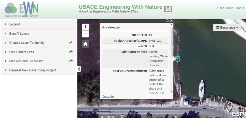
ERDC TN-EWN-15-1
July 2015

There are 13 AIPT selections currently available in EWN ProMap (Table 2), although this list is
easily expandable for other types of water resources infrastructure when appropriate examples
are identified. Thus, individuals who are planning navigation dredging projects, shore protection
projects, breakwaters, or other project types can use these AIPT selections to identify similar
projects, which they can consult for ideas and technical resources. Menus also have a “Default”
icon that displays when no information is present for a particular data field. Users can also utilize
the Basemap drop-down menu in the upper left of the screen to select from among several
different map backgrounds.

          Table 2. EWN ProMap AIPT and EWN selections available on the
          tool panel.
          Available AIPT Selections            Available EWN Benefit Selections
          Breakwater                           Aesthetics
          Bulkhead                             Beach nourishment
          Chevron                              Bird habitat
          Dike                                 Fish habitat
          Groin                                Invertebrate habitat
          Jetty                                Island restoration
          Multiple round point                 Mammal habitat
          Navigation dredging                  Recreation
          Other in-water construction          Reptile habitat
          Pier/wharf                           Shore protection
          Revetment                            Vegetated habitat
          Seawall
          Shore protection

For each project, the three different intended EWN benefits are included in the database. In many
cases, when projects were being researched for inclusion in ProMap, the EWN benefits were not
explicitly stated in the available project documentation. In these situations, the study team
assigned benefits based on reasonable assumptions. For example, reef breakwaters will typically
provide habitat for both fish and invertebrates. In the absence of information to the contrary for
this example, the team assigned fish habitat for reef breakwaters as EWNB1 and invertebrate
habitat as EWNB2. In other cases, such as with the Wilmington offshore fisheries enhancement
structure (WOFES), the first EWN benefit clearly was for fish habitat enhancement (Reine et al.
2012). The EWN benefit selections currently included in EWN ProMap are provided in Table 2.

EWN ProMap also has a function that allows users to submit sites that they believe should be
included in the database. The user should first navigate to the project and zoom the map in to the
location. The process is then initiated by the user clicking on the Request New Case Study portion
of the tool panel. This opens a small window where the user selects the AIPT (Figure. 7). Once the
AIPT is selected, the user needs to click on the map at the project location. This will automatically
provide the geographic coordinates for the database. This will also cause a pop-up window to

                                                 6
ERDC TN-EWN-15-1
                                                                                        July 2015

appear where the user is prompted to fill in the site name, site owner, EWN benefits, a site descrip-
tion, and any supporting hyperlinks. Once the user has provided all the available information, the
Stop Editing button should be clicked, which will save the information and send a notification to
the site administrator to review the submission. An EWN ProMap administrator will review the
project for approval based upon whether it fits the EWN essential ingredients (see Page 1).

Figure 7. The case study submission portion of the tool panel is shown with ProMap zoomed to project
          scale.

SUMMARY AND NEXT STEPS: This document summarizes the development of a geography-
based mapping resource tool, EWN ProMap, for projects that fit within the Engineering With
Nature (EWN) context. Engineering With Nature is the intentional alignment of natural and
engineering processes to efficiently and sustainably deliver economic, environmental, and social
benefits associated with water resources projects through collaborative processes. EWN ProMap
enables users to search for information when developing EWN ideas during the planning of
projects. Esri’s ArcGIS™ Application Programming Interface for Flex was selected as the
platform on which to build ProMap, due to its pan, zoom, search, and site screening capabilities.

EWN ProMap is an evolving tool. For many projects, the information in the database is only
partially complete. In other cases, the database currently only contains a representative number
of a particular project class. For example, river training structures that reflect EWN goals, such
as chevrons and notched dikes, have been identified for the stretch of the Mississippi River
which the St. Louis USACE District manages. However, additional efforts are needed to identify
similar structures on the remaining portions of the Mississippi River and also on the Missouri
River. Similarly, the EWN ProMap includes a number of reef breakwater projects, but this list is
incomplete since additional known reef projects will be incorporated once more information
about them is received. The team also expects that as users become aware of EWN ProMap, they
will recommend additional projects for the database using the site submission feature.

                                                  7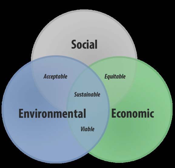
ERDC TN-EWN-15-1
July 2015

Future enhancements for EWN ProMap include (1) the ability to export information to other
platforms such as Google Earth and (2) integration with other USACE enterprise systems such as
CorpsMap (USACE 2013). The Esri Portal software platform that is being used will facilitate
these efforts due to its compatibility with these other venues.

POINT OF CONTACT: for additional information, contact Dr. Burton Suedel (601-634-4578,
Burton.Suedel@usace.army.mil). This technical note should be cited as follows:

        Fredette, T. J., B. C. Suedel, A. V. Davis, and C. J. Banks. 2015. Engineering
        With Nature geographic project mapping tool (EWN ProMap). EWN Technical
        Notes Collection. ERDC TN-EWN-15-1. Vicksburg, MS: U.S. Army Engineer
        Research and Development Center. http://el.erdc.usace.army.mil/.

REFERENCES
Bridges, T. 2012. Engineering With Nature. Fact Sheet. U.S. Army Corps of Engineers. Available at
    http://el.erdc.usace.army.mil/ewn/ (accessed 20 November 2013).
Fredette, T. J., C. M. Foran, S. M. Brasfield, and B. C. Suedel. 2011. Environmental enhancements and navigation
    infrastructure: a study of existing practices, innovative ideas, impediments, and research needs. U.S. Army
    Corps of Engineers Technical Report. ERDC/EL TR-11-7. Website: http://el.erdc.usace.army.mil/elpubs/
    pdf/trel11-07.pdf. (accessed 20 November 2013).
Fu, P. and Sun, J. 2011. Web GIS: principles and applications. Redlands, CA: ESRI Press.
Reine, K. J., D. Clarke, and C. Dickerson. 2012. Fishery resource use of an offshore dredged material mound.
    DOER Technical Notes Collection. ERDC TN DOER-E31. Vicksburg, MS: U.S. Army Engineer Research and
    Development Center. http://el.erdc.usace.army.mil/elpubs/pdf/doere31.pdf. (accessed 20 November 2013).
U.S. Army Corps of Engineers (USACE). 2013. U.S. Army Corps of Engineers – Geospatial Portal. Available at
    http://geoplatform.usace.army.mil/home/ (accessed 18 December 2013).

                                                        8
You can also read