EROSIONAL-DENUDATIONAL VALLEYS AND THEIR SIGNIFICANCE FOR THE RECONSTRUCTION OF THE LATE GLACIAL ENVIRONMENTAL CONDITIONS...
←
→
Page content transcription
If your browser does not render page correctly, please read the page content below
Erosional-denudational valleys and their
    significance for the reconstruction of the Late
          Glacial environmental conditions...
                                      QUAESTIONES GEOGRAPHICAE 30(3) • 2011

      Erosional-denudational valleys and their
   significance for the reconstruction of the Late
   Glacial environmental conditions (the Drawsko
                Lakeland, NW Poland)

                                          Renata Paluszkiewicz
    Adam Mickiewicz University, Institute of Geoecology and Geoinformation, Department of Geoecology,
                                              Poznań, Poland

                                        Manuscript received: July 7, 2011
                                       Revised version: September 2, 2011

Paluszkiewicz R., 2011. Erosional-denudational valleys and their significance for the reconstruction of the Late
Glacial environmental conditions (NW Poland - the Drawsko Lakeland). Quaestiones Geographicae 30(3), Bogucki
Wydawnictwo Naukowe, Poznań, pp. 71–81, 5 Figs. ISBN 978-83-62662-75-3. ISSN 0137-477X. DOI 10.2478/
v10117-011-0028-7
Abstract. The article presents the morphological-lithological development and operation of dry erosional-denu-
dational valleys located on morainic uplands in the Drawsko Lakeland. A detailed research was carried out on
the morainic upland of the Buślarka and Piaski Pomorskie area. A geodetic study made it possible to identify
over ten NW-SE and N-S oriented erosional-denudational valleys, clearly marked in the relief. They are small
landforms: their length does not exceed 100 m, and the depth of incision reaches 4 m. Their exact morphometric
description with the help of GIS methods and a detailed study of lithofacies characteristics of their deposits
provided an insight into their operation. They follow a Late Glacial pattern in which Late Vistulian erosion only
rejuvenated the already existing older forms.
Keywords: erosional-denudational valleys, upland scarps, morphometric features, Drawsko Lakeland, West Po-
merania
Renata Paluszkiewicz, Adam Mickiewicz University, Institute of Geoecology and Geoinformation, Department of
Geoecology, Dzięgielowa 27, 61-680 Poznań, Poland, e-mail: reniach@amu.edu.pl

Introduction                                               in the 1960s, e.g. Marsz’s (1964) concerning the
                                                           Kashubian Pradolina, Churska’s (1965) dealing
   The earliest works dealing with the genesis             with the Warta-Noteć Pradolina and the Drwęca
and later the age of dry valley landforms rested           valley, or Kostrzewski’s (1963) from the Leszno
on an analysis of their morphometric features              Upland. Those authors focused on the systems of
(Passarge 1924, after Klatkowa 1965). The opin-            small, dry valleys dissecting scarp zones. They
ion about the glacial or postglacial age of those          were in agreement about the “periglacial charac-
landforms in northern Poland was first advanced            ter of the relief”, although their opinions differed
by Okołowicz (1947). The first postwar studies             as to the period of intensive development of the
by Polish authors concerning denudational land-            valleys. According to Marsz, the chief stages of
forms in the postglacial region only appeared              their formation occurred in the interstadial pe-
72                                                 Renata Paluszkiewicz

riods of the Late Glacial, while Churska was of                 ern Baltic Lakeland) and is a part of the Drawsko
the opinion that those processes took place in the              Lakeland meso-region (Fig. 1). The research cov-
cold periods.                                                   ered 289.51 km2 of the catchment of the Dębnica
   The literature on dry valleys largely deals with             river, a left-bank tributary of the Parsęta. The
the upland regions of Poland (e.g. Dylik 1953;                  principal hydrographic artery of this area, the
Jahn 1956; Klatkowa 1965; Maruszczak 1968). The                 Dębnica carries water away from postglacial up-
latest studies addressing denudation issues, still              lands. There are two terraces in the valley floor:
infrequent, also tackle the effect of human activ-              the floodplain and a cut-and-built terrace above
ity on its pattern (Borówka 1992, 1994; Smolska                 it. With a channel gradient of 0.5‰, the river me-
2002; Szpikowski 2005). Despite a considerable                  anders within its valley floor, whose width grows
body of literature on the subject, studies of the               considerably, locally to more than 1 km. In the
operation and formation of valley landforms in                  scarp zones of morainic uplands and on slopes of
postglacial areas, including the Drawsko Lake-                  valleys there are distinct small erosional-denuda-
land, are still scarce.                                         tional valleys and gullies, either drained episodi-
   The aim of this article is to describe the devel-            cally or dry. On the slopes of the Dębnica valley
opment and operation of erosional-denudational                  numerous such erosional-denudational valleys
valleys. Through a geomorphological analysis of                 were found to occur (Paluszkiewicz 2007, 2008,
selected valleys in the Drawsko Lakeland, it was                2009). A detailed research was conducted in two
demonstrated how significant they were for the                  areas: the Buślarka upland zone and the Piaski
reconstruction of Late Glacial conditions.                      Pomorskie upland zone (Fig. 1).

Study area                                                      Morainic upland in the Buślarka area

   In geographical terms (Kondracki 2000), the                     The study area embraced the scarp of the mo-
study area lies in the macro-region of the West                 rainic upland in the Buślarka area (some 2 km NE
Pomeranian Lakeland (sub-province of the South-                 of Połczyn Zdrój). According to the geomorpho-

Fig. 1. Location of study area (Global data base GTOPO30 http://edcdaac.usgs.gov/gtopo 30/gtopo30.html processed by
                                                       A. Stach).
                                     1 – watershed, 2 – river network, 3 – study area.
Erosional-denudational valleys and their significance for the reconstruction of the Late Glacial environmental conditions... 73
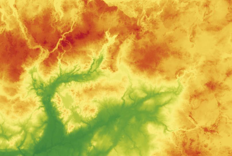
logical sketch on the Połczyn Zdrój sheet (Do- ance and development of erosional-denudational
bracka 2009; Fig. 2), an undulating morainic up- valleys. Their orientation is perpendicular to the
land extends here in the hinterland of morainic valley axis and they feature distinctly in the relief,
hills, and its elevation varies between 120 m a.s.l. being incised into the upland surface to a depth
in the northern part to 180 m a.s.l. in the south. of 2 to 4 m.
Its feature of special interest is its scarp running Along the entire length of the scarp extend-
NE-SW. What give its surface a unique character ing for some 4 km, a total of 16 NW-SE-oriented
are the upper and middle sections of erosional- erosional-denudational valleys were identified,
denudational valleys that rise in its area. The clearly marked in the relief. All of them are dry,
wide zone of the long slope on the eastern side but three display a permanent runoff. Most of
of the Buślarka Hills is strewn with numerous them are single landforms varying in length from
denudational valleys. The slope zone extends more than ten to more than 100 m, but there are
from the top of the upland at an altitude of 150 m also some that consist of a trunk valley and sev-
a.s.l. down to 80 m a.s.l. in a belt varying from 0.7 eral lateral ones.
to 1.2 km in width. As Dobracka (2009) reports, Within the scarp zone, in its southern and
this highly denudated slope is built of sandy gla- central parts, the valleys are incised in sands and
ciofluvial deposits underlying glacial tills. The gravels with an admixture of boulders. Those de-
marked inclination of the upland surface towards posits lie on the land surface under a thin cover
the Dębnica valley has given rise to the appear- of glacial tills and sands, and crop out on the
Fig. 2. Geomorphological sketch of the research area (Dobracka 2009).
1 – undulated ground morainic plateau, 2 – accumulation end moraine, 3 – kames, kame plateau, 4 – final cavity (melt), 5 – river terracy
2,0–5,0 m n.p. river, 6 – valleys, ravines and young cut erosion, inseparable, 9 – dry valleys, 10 – denudation valleys, 11 – long slopes, 12 –
study area.74 Renata Paluszkiewicz
slopes of the Dębnica valley, also in the region ments were carried out using Elta RAR 50 equip-
of the Buślarka Hills. In the northern part of the ment and, when necessary, supplemented with
scarp, certain differences in the deposits can be tachymetric measurements. Such precise meas-
observed: the outlet sections of the valleys are in- urements of the erosional dissections, combined
cised in sand-gravel deposits, while their middle with geomorphological mapping with the use of
and upper reaches are incised in sand-silt-gravel GIS methods, allowed making height profiles as
deposits, which occur here in the form of covers well as transverse and longitudinal cross-sections
of varying thickness on ground-morainic tills. of the valleys.
The thickness of deposits differs; it attains a max- To solve the research problem posed, it was of
imum of 5 m. fundamental importance to determine the geolog-
ical structure of the study area. The basic sources
of information were exposures and profiles made
Morainic upland of the Piaski Pomorskie within them, while borings played an auxiliary
area role in this task. An analysis of deposits in the
exposures provided a basis for a reconstruction
The scarp of the morainic upland of the Piaski of sedimentation conditions. In addition, cuttings
Pomorskie region shows a W-E orientation (Fig. and exposures were made on the slopes and in
2). Its length is about 6 km, and its absolute al- the floors of the landforms examined.
titude ranges from 100 to 125 m a.s.l. The scarp The next research stage involved a laboratory
is dissected by numerous small, dry erosional- examination of samples taken in the field. Labo-
denudational valleys differing in length and the ratory analyses and the accompanying indoor
depth of channel incision. Along the length of the processing of their results embraced the follow-
scarp an inventory was made of 20 dissections ing:
running N-S, clearly discernible in the relief. Less –– an analysis of the mechanical composition
distinct in the relief are the alluvial cones accom- of deposits using Cassagrande’s areometric-
panying the valleys. sieve method modified by Prószyński (Raci-
By the subzones of the Parsęta lobe distin- nowski 1973; Płochniewski 1986),
guished by Karczewski (1989), the study area is –– determination of the calcium carbonate
situated on the highest, 7th, level of the morainic (CaCO3) content using Scheibler’s apparatus,
upland of the northern slope of Pomerania. The and
dominant elements of the relief are an undulat- –– an analysis of the abrasion grade of quartz
ing morainic upland in the north and valleys and grains using Krygowski’s (1964) mechanical
cut-and-built meltwater plains in the south. In the graniformametry method for the fractions of
western part there are dead-ice morainic hills. 1.25–1.0 mm and 1.0-0.8 mm.
To handle the results obtained during field-
work and laboratory analyses and to process car-
Study methods tographic material, use was made mostly of the
software available in the Department of Geoecol-
In order to make the right choice of landforms ogy and the Faculty of Geographical and Geo-
for a representative study even before fieldwork, logical Sciences of Adam Mickiewicz University
an analysis was made of archival topographic in Poznań.
maps at a scale of 1:10 000, which allowed such
a selection. Because of the insufficient accuracy
of the topographic maps and the size of the val- Morphometric features of the valleys
leys, it was necessary to perform direct topo- and their paleogeographical reading
graphic measurements of those landforms. Their
accuracy is especially important because of the The slope asymmetry of dry valley landforms
propagation of error when calculating deriva- is a widely known phenomenon and has been
tive topographic parameters (gradient, length of frequently addressed in the literature (e.g. Mojski
dissections, floor width, depth). The measure- 1950, Jahn 1956, Maruszczak 1956, Churska 1965,Erosional-denudational valleys and their significance for the reconstruction of the Late Glacial environmental conditions... 75 Klatkowa 1965, Gołębiewski 1981). It is thought asymmetry’: the slopes with a warm exposure to be connected primarily with the dominant role tend to be steeper. A similar dependence was ob- of climatic factors responsible for differences in served by Churska (1965) in dry valleys of north- the processes working on the opposite slopes ern Poland, within the Kujavia Stage. According and their dynamics. When analysing the trans- to Tricart (1950), on slopes with a southern ex- verse profiles of the valleys in the study area, posure permafrost is poorly developed, which this dependence was found to hold for the Piaski makes them defrost and dry quickly in spring. Pomorskie scarp zone (Paluszkiewicz 2009). The Thus, the role of regelation and cryoturbation in profiles show an asymmetry in which the slope slope modelling is small. On shaded north-facing with an eastern exposure is gentler (Figs. 3, 4). slopes permafrost is better developed and the Differences in the gradients of the steep and the slopes are made gentler by intensive slope proc- gentle slope attain a few degrees (2o–9o). In the esses. The asymmetry suggests that the valleys valleys that have formed in the Buślarka upland started to form already in the Late Vistulian. An- zone, differences in the inclination of the E and other indication is the absence of alluvial cones at W slopes are slight, about 2o. The asymmetry is their outlets. slight, but significantly regular; it is as a rule ‘heat Fig. 3. Hypsometric map of erosional-denudation valley together with its long and transverse profiles for Buślarki area.
76                                                   Renata Paluszkiewicz

    The dissections under study differ in their                 dissections have a stepped profile. The analysis
mode of formation and morphometric features.                    of the long profiles of the valleys clearly shows
In terms of size, they are small landforms (Figs 3,             their middle parts to have undergone the deep-
4). Most are single valleys 30 to 130 m long, but               est incision in relation to the original surface. The
there are also some consisting of a trunk valley                profile gradient is about 6o on average. The floor
joined by one or several lateral ones (Fig. 4).                 becomes flatter down-valley and the boundary
    Lateral valleys hang above the floor of the                 between the floor and the slopes grows more dis-
trunk valley, which is evidence of their later for-             tinct. This is a result of the accumulative charac-
mation. Their length is small (a maximum of a few               ter of the floor, on which has gathered material
metres). Most have a flat floor. The depth of the               transported from the up-valley sections. The gra-
incisions displays considerable differences along               dient decreases towards the outlet of the valleys.
the entire length; the deepest incised sections are             In turn, their transverse profiles (S-N and SW-NE
the central ones, to about 3–4 m, and the least in-             oriented) show the greatest gradients in the mid-
cised are the outlet ones. The long profile, running            dle parts, up to a maximum of 26o, while at the
W-E and NW-SE, is usually even, although some                   outlet they range from 10o to 23o.

Fig. 4. Hypsometric map of erosional – denudation valley together with its long and transverse profiles for Piaski Pomorskie
                                                           area.
Erosional-denudational valleys and their significance for the reconstruction of the Late Glacial environmental conditions... 77
Lithofacies characteristics of deposits (1964) mechanical graniformametry method.
In the light of his typology, the most frequent
To determine the lithofacies variability of de- quartz grains in the deposits are those of type
posits, they were characterised on the basis of cut- α, characterised by very low abrasion. This type
tings and hand borings made both in the valleys of quartz grains of the sand fraction is charac-
and in the upland zone. The details allow some teristic, among other things, of glacial environ-
generalisations and the tracing of lithofacies pat- ments, which are enriched with cracked grains or
terns characteristic of the head and outlet sections ones without abrasion. In this environment the
of the studied landforms. The dominant group grains do not alter the character of the surface;
of deposits is fine sands accounting for 41.3% of rather, they undergo conservation (Goździk &
the population (44 samples). The proportions of Mycielska-Dowgiałło 1982). The abrasion grade
the remaining fractions look as follows: medium of quartz grains of sand plays an important role
sand – 36%, coarse gravel – 17.4%, fine gravel – in the genetic and dynamic interpretation of
3.8%, medium gravel – 1.3%, and fine silt – 0.2%. Quaternary deposits (Mycielska-Dowgiałło &
In the head zones of a decided majority of the val- Woronko 1998). It allows drawing conclusions
leys one can distinguish three basic lithofacies: about processes working on the deposits and
–– a sand-stone near-surface layer (the initial conditions holding in the period preceding their
stage in the development of the valleys); deposition and transport.
–– a layer of the erosional pavement; and The examination of the abrasion grade of
–– a series of massive fine and medium-grained quartz grains shows a marked bimodality of the
sands. distribution and a considerable predominance of
The series observed in the lowest parts of the grains of type β, i.e. ones of a medium level of
erosional-denudational valleys are largely a con- abrasion. The bimodality shows in a great pro-
tinuation of those in the central sections. The fol- portion of angular material (type α, up to 60%)
lowing lithofacies were distinguished: and intermediate one (type β, up to 40%). Such
–– a series of fine yellow sands, genetically con- a distribution of the grain mass is indicative of
nected with surface runoff and slope wash, admixtures from various environments, as point-
–– a stone-gravel layer providing resistance ed out by Kostrzewski (1971). The observed pre-
against a further lowering of the erosional dominance of grains of type β can even exceed
base of the valleys, and 90%; such a high proportion of this type of grains
–– fine sands with flow-derived gravel-stone in- may additionally indicate a substantial degree of
tercalations, which are a continuation of the aeolisation of the mineral material. Differences in
in situ series of the central sections of the val- the abrasion grade of grains are easy to observe
leys. when expressed by the abrasion index Wo, which
To learn about differences in the sedimentary assumes values in excess of 1000 for deposit sam-
environment in the head and outlet zones of the ples with a high content of grains of type β.
valleys, a comparison was made of the frequency
curves of deposits (Fig. 5). There is a readily vis-
ible difference in their shapes. Those for the lower A reconstruction of the dynamics
parts of the valleys show elevated levels of coarser of denudational processes
material, here coarse sands and gravels. The fre-
quency curves for the upper parts display two Late Vistulian slope processes started in the
main modes corresponding to the fractions of me- uplands of the Dębnica valley region after the re-
dium and fine sands. A more distinct mode in the cession of the last inland ice, i.e. about 15 ka BP.
coarser fraction shows the supply of this material With its retreat, waters flowing in marginal val-
to prevail in the heads of the valleys. It was also leys changed course towards the north, cutting
observed that deposits in the outlet sections were successive younger marginal zones and creat-
poorer sorted than those in the upper parts. ing water-gaps. In turn, the melting of dead-ice
The sand lithofacies was analysed for the abra- blocks started the inclusion of subglacial tun-
sion grade of quartz grains using Krygowski’s nel valleys, terminal basins and melt-out basins78 Renata Paluszkiewicz
Fig. 5. Examples of frequency curves for the upper sections of the valley (A) and lower sections of the valley (B) (Dębnica
valley, West Pomerania).
into the river system (Florek 1991; Błaszkiewicz Because of insufficient evidence in deposits,
1998, 2005). The final stage of dead-ice melting the stages of formation of the valleys were re-
saw a reorientation of the direction of meltwater constructed with the help of the literature on the
flow towards the Białogard basin in the north. subject. Presumably, the first stage can be dated
As a result of heavy bottom and lateral erosion, to the Oldest Dryas. As Kozarski (1995) claims, at
there developed a broad meltwater channel in that time the climate in northern Poland was cold
the Dębnica trough with a system of three lev- and dry, with a mean annual temperature of –1oC
els of cut-and-built terraces. Towards the end of favourable to the persistence of permafrost. The
the Pleistocene there formed a terrace above the predominant type of vegetation was dwarf-shrub
Dębnica floodplain and small hillocks of dunes tundra (Tobolski 1998). In such conditions, there
(Dobracka, 2009). Along the upland scarps nu- was intensive denudation in the upper parts of
merous denudational valleys developed, later the valleys (Maruszczak 1968), while solifluction
filled with diluvial material. predominated in the lower sections in the north.Erosional-denudational valleys and their significance for the reconstruction of the Late Glacial environmental conditions... 79
When describing the evolution of valleys and floors becoming covered with deposits deriv-
hollows on the slopes of the Warta-Noteć Pra- ing primarily from wash. A short-lived increase
dolina, Churska (1965) observes that what could in the role of accumulation in the colder stage
be an impulse for the development of erosional is also mentioned by Maruszczak (1968). In the
hollows were cracks in the land surface, and in erosional-denudational valleys under study it is
the case of dry valleys, mass movement on the hard to identify with any certainty slope series
slopes, but with water flowing down the slopes whose formation might be connected with the
and along their axes as the dominant factor. In Older Dryas.
turn, for Marsz (1964, 1995) the first stage of de- In the Alleröd, erosion comes to prominence
velopment of valleys dissecting the scarp of the again in the formation of the valleys (Marsz
Kashubian Pradolina involved the appearance 1964,1995; Maruszczak 1968), facilitated by
of hollows produced by erosion and intensive a very small supply of material from the catch-
denudation that accompanied it. One of the chief ments of the valleys owing to the presence of the
processes initiating the formation of the valleys plant cover and an increase in humidity. Erosion
studied was the erosional action of water flow- was the heaviest during intensive rainfalls in the
ing down the slopes. Also Gołębiewski (1981) be- lower and middle parts of the valleys, which was
lieved erosion to have played a major role in the certainly connected with the considerable gradi-
first period of development of dry valleys. ent of their long profile in the middle sections.
In the Bölling, owing to the degradation of In the Younger Dryas the role of denudation
permafrost in entire central Europe, the role of in slope formation increased again. The material
solifluction in the modelling of the valleys de- transported downslope accumulated on the val-
clined sharply (Kozarski 1995), which was due, ley floors (Marsz 1964, 1998; Maruszczak 1968).
among other things, to the appearance of a com- There developed thin covers of slope deposits of
pact plant cover. In the central part of north-west- a much smaller extent than in the Oldest Dryas.
ern Poland, it was already in the Bölling that an It was a period of marked cooling and a drop in
initial birch-dominated forest appeared (Tobolski humidity, which activated slope processes in the
1998). A dense plant cover certainly also greatly already well-developed valleys and reduced ero-
reduced slope wash in the valleys. The process sion along their floors. Conditions at the Late Vis-
that crucially contributed to their development tulian-Holocene boundary – a climatic warming,
was erosion advancing along their floors. Its in- an increase in humidity – could make slope proc-
tensity could be due to great amounts of water esses more intensive (Ralska-Jasiewiczowa et al.
from the melting permafrost, which survived in 2003). Presumably, there could also still appear
the ground despite the Bölling warming (Kozar- solifluction because of the shallow-lying perma-
ski & Nowaczyk 1995). The gradual advance of frost. The appearance of man and his economic
a compact plant cover effectively reduced the activity – slash-and-burn agriculture and land
supply of material along the slopes, which in turn cultivation – contributed to the activation of slope
made destructive action easier. A visible indica- processes in the younger Holocene. From the be-
tion of Bölling erosion is the erosional pavement ginning of the Holocene to the start of human set-
found in the valleys in the form of gravel-stone tlement, slope deposits were almost completely
levels. Among the authors who wrote about ero- absent, as found by e.g. Starkel (1989), Borówka
sional stages within dry valley landforms in peri- (1992, 1994), Twardy (2000), and Smolska (2003).
ods of climate amelioration and increased humid- Neo-Holocene diluvial deposits appear in only
ity are Klatkowa (1965), and about erosion in the those landforms near which man carried out his
Bölling, Marsz (1964) and Maruszczak (1968). economic activity.
In the short cold stage of the Older Dryas, as In one of the erosional-denudational valleys
Ralska-Jasiewiczowa & Starkel (1991) claims, the of the Piaski Pomorskie scarp zone, peat deposits
advance of forest formations could stop, or even lying at a depth of 1 m below ground-level were
suffer a reversal. The role of erosion in the shap- dated using the 14C method. The exposure was
ing of the valleys weakened, also as a result of situated in the distal part of the alluvial cone. The
climate change. This could result in the valley analysis embraced three samples: the bottom of80 Renata Paluszkiewicz
the peat deposits was dated to 2 100±30 BP (Poz– Acknowledgment
22990, calibrated to 198BC (95.4%) 46 BC using
the OxCal program), the central part, to 1 965±35 This paper is supported by the founds intend-
BP (Poz–229910, 44 BC (91.0%) 88 AD), and the end by Polish Ministry of Science and Higher Ed-
top, to 1 835±35 BP (Poz–22992, 81 AD (95.4%) ucation for science in years 2007–2010 as research
253 AD). The content of organic matter in the project No N 306 012 32/0865.
samples exceeded 80%. The above 14C dates show
the valley to have formed in the Sub-Atlantic pe-
riod. When correlating them with archaeological References
studies conducted in Central Pomerania, one can
Błaszkiewicz M., 1998. Dolina Wierzycy jej geneza oraz roz-
find that in the Roman period the lands near the wój w późnym plejstocenie i wczesnym holocenie. Dok.
examined valleys were densely inhabited by peo- Geogr. 10.
ple of the Wielbark culture (Machajewski 2006). Błaszkiewicz M., 2005. Późnoglacjalna i wczesnoholoceńska
ewolucja obniżeń jeziornych na Pojezierzu Kociewskim
At that time the chief factor activating slope proc- (wschodnia część Pomorza). Pr. Geogr. IGiPZ PAN 201.
esses was human activity. Borówka R.K., 1992. Przebieg i rozmiary denudacji w obrębie
śródwysoczyznowych basenów sedymentacyjnych podczas
późnego vistulianu i holocenu. UAM, seria Geografia 54,
Poznań.
Conclusions Borówka R.K., 1994. Naturalne i antropogeniczne uwarun-
kowania zmian denudacji podczas holocenu. Rocz. AR
The research conducted in West Pomerania 266: 27–37. Poznań.
Churska Z., 1965. Późnoglacjalne formy denudacyjne na
made it possible to identify tens of erosional- zboczach pradoliny Noteci–Warty i doliny Drwęcy. Stud.
denudational valleys located within morainic Soc. Scient. Torun., Sec. C, Geogr. et Geol. 6: 112.
uplands. Those on the morainic upland discussed Dobracka E., 2009. Objaśnienia do szczegółowej mapy geologicz-
nej Polski w skali 1: 50 000. Arkusz Połczyn Zdrój (158).
in this article are landforms in which Late Vistu- Dylik J., 1953. O peryglacjalnym charakterze rzeźby środko-
lian erosion only rejuvenated the already existing wej Polski. Acta Geogr. Lodz. 4.
older forms. They are valley systems following Florek W., 1991. Postglacjalny rozwój dolin rzek środkowej części
północnego skłonu Pomorza. WSP, Słupsk.
an old pattern. Their geomorphological charac-
Gołębiewski R., 1981. Kierunki i intensywność denudacji na
teristics presented in the article allow some gen- obszarze zlewni Raduni w późnym würmie i holocenie.
eralisations. They are small landforms whose Zesz. Nauk. UG, Rozprawy i Monografie 26. Gdańsk.
length does not exceed 100 m, and the depth of Goździk J., Mycielska-Dowgiałło E., 1982. Badania wpływu
niektórych procesów geologicznych na przekształce-
incision attains up to 4 m. In their long profile the nia powierzchni ziarn kwarcowych. Przegl. Geol. 54(3):
following parts can be distinguished: valley head 219–241.
– narrow-floor section – widening outlet section Jahn A., 1956. Wyżyna Lubelska. Rzeźba i czwartorzęd. Pr.
Geogr. IG PAN 7.
– alluvial fan. Alluvial fans of the valleys under Karczewski A., 1989. Morfogeneza strefy marginalnej fazy po-
analysis are not prominent features of the relief. morskiej na obszarze lobu Parsęty w vistulianie (Pomorze
The most incised middle segments of the valleys Środkowe). Wyd. Nauk. UAM, Poznań: 48.
have sides with the steepest slope angle, even in Klatkowa H., 1965. Niecki i doliny denudacyjne w okolicach
Łodzi. Acta Geogr. Lodz. 19.
excess of 26°. In deposits, where the dominant Kondracki J., 2000. Geografia fizyczna Polski. PWN, Warsza-
fraction is fine sand, there is a marked zone of wa.
erosion pavement – a stone-gravel layer which is Kostrzewski A., 1963. Morfologia ostrowskiej wyspy wyso-
czyznowej pod Gostyniem. Bad. Fizjogr. nad Pol. Zach.
a barrier to further lowering of the erosion base 11: 191–202.
of the valleys. In view of the nature of the depos- Kostrzewski A., 1971. Niecki denudacyjne w krawędzi wyso-
its, the basic processes modelling the develop- kiej terasy ujściowego odcinka doliny Bobru. Bad. Fizjogr.
nad Pol. Zach. 24: 77–95.
ment of the valleys must be those of wash and
Kozarski S., 1995. Deglacjacja północno-zachodniej Polski:
erosion. Today, the deforestation of their scarp warunki środowiska i transformacja geosystemu (~20 ka
zones significantly limits further development → 10 ka BP). Dok. Geogr. 1.
of the valley landforms, and their dry floors are Kozarski S. & Nowaczyk B., 1995. The Boling Interstadial at
Żabinko and Late Vistulian environmental changes in
largely shaped by episodic water flows. the middle reach of the Warsaw-Berlin pradolina. Quater.
Stud. in Poland 13: 43–53.Erosional-denudational valleys and their significance for the reconstruction of the Late Glacial environmental conditions... 81
Krygowski B., 1964. Graniformametria mechaniczna. Teoria, Paluszkiewicz R., 2008. Charakterystyka osadów stożka na-
zastosowania. Pr. Kom. Geogr.-Geol. PTPN 4. pływowego suchej dolinki erozyjno-akumulacyjnej Pia-
Lewandowski J. & Nita M., 2008. Ewolucja systemu hydrogra- ski Pomorskie (Pomorze Zachodnie). Landform Analysis
ficznego i szaty roślinnej dorzecza górnej Piławy i górnej 9: 68–71.
Drawy (Pomorze Środkowe). Przegl. Geol. 56(5): 380–390. Paluszkiewicz R., 2009. Zróżnicowanie litologiczne osadów
Machajewski H., 2006. Pomorze Środkowe w okresie rzym- dolinek erozyjno-denudacyjnych (Pomorze Zachodnie).
skim i we wczesnej fazie okresu wędrówek ludów. In: In: A. Kostrzewski, R. Paluszkiewicz (eds.), Geneza, lito-
W. Nowakowski (ed.), Goci na Pomorzu Środkowym. Ko- logia i stratygrafia utworów czwartorzędowych. 5. Seria
szalin: 35–63. Geografia 88: 383–406.
Maruszczak H., 1956. Główne cechy klimatycznej asymetrii Płochniewski Z., 1986. Hydrogeologia i geologia inżynierska.
stoków w obszarach peryglcjalnych i umiarkowanych. Wyd. Geol., Warszawa.
Ann. UMCS 11(5): 161–207. Racinowski R., 1973. Analiza uziarnienia. In: E. Ruhle (ed.),
Maruszczak H., 1968. Procesy denudacyjne w późnym gla- Metodyka badań osadów czwartorzędowych. Wyd. Geol.,
cjale i holocenie w świetle badań suchych dolin w Polsce. Warszawa: 331–335.
Folia Quater. 29: 79–87. Ralska-Jasiewiczowa M. & Starkel L., 1991. Ewolucja szaty
Marsz A., 1964. O rozcięciach erozyjnych krawędzi Pradoli- roślinnej. In: L. Starkel (ed.), Geografia Polski. Środowisko
ny Kaszubskiej między Gdynią a Redą. Bad. Fizjogr. nad przyrodnicze. PWN, Warszawa: 177–182.
Pol. Zach. 13: 113–154. Ralska-Jasiewiczowa M., Goslar T., Różański K., Wacnik A.,
Marsz A., 1995. Rozmiary erozji i denudacji późnoglacjalnej Czernik J. & Chróst L., 2003. Very fast environmental
na północnym skłonie Pojezierza Kaszubskiego i Pobrze- changes at the Pleistocene/Holocene boundary, record-
żu Kaszubskim. In: W. Florek (ed.), Geologia i geomorfo- ed in laminated sediments of Lake Gościa, Poland. Paleo-
logia Pobrzeża i południowego Bałtyku. 2. WSP, Słupsk: geography, Paleoclimatology, Paleoecology 193: 225–247.
139–152. Starkel L., 1989. Antropogeniczne zmiany denudacji i se-
Marsz A., 1998. Geneza i zanik ochłodzenia globalnego w dymentacji w holocenie na obszarze Europy Środkowej.
późnym glacjale jako efekt współdziałania w systemie Przegl. Geogr. 61(1–2): 25–32.
zlodowacenie–ocean–atmosfera. In: J. Repelewska-Pę- Smolska E., 2002. Denudacja antropogeniczna – zapis w
kalowa (ed.), IV Zjazd Geomorfologów Polskich „Rzeźba, rzeźbie i osadach na wybranych przykładach z obszaru
paleogeografia czwartorzędu oraz problemy zmian środowiska Pojezierza Suwalskiego. In: P. Szwarczewski, E. Smolska
obszarów polarnych”, Lublin: 89–96. (eds.), Zapis działalności człowieka w środowisku przyrodni-
Mazurek M., Paluszkiewicz R. & Piotrowska I., 2010. Walory czym, 1: 113–119.
turystyczne sieci dolinnej w dorzeczu Parsęty. Krajobraz Smolska E., 2003. Współczesne i holoceńskie tempo denu-
a turystyka. Pr. Kom. Krajoz.-Kultur. PTG 14: 207–220. dacji stoków Pojezierza Suwalskiego. In: R. Gołębiewski
Mojski J.E., 1950. Asymetria zboczy dolinnych w dorzeczu (ed.), Ewolucja Pojezierzy i Pobrzeży Południowobałtyckich.
Bystrzycy. Ann. UMCS V(2): 27–49. Gdańsk: 111–119.
Mycielska-Dowgiałło E. & Woronko B., 1998. Analiza ob- Tobolski K., 1998. Stan poznania historii lasów, jezior i tor-
toczenia i zmatowienia powierzchni ziarn kwarcowych fowisk Borów Tucholskich. In: J. Banaszak, K. Tobolski
frakcji piaszczystej i jej wartość interpretacyjna. Przegl. (eds.), Park Narodowy Bory Tucholskie. WSP, Bydgoszcz:
Geol. 46(12): 1275–1281. 19–48.
Okołowicz W., 1947. Rekonstrukcja klimatu i jego zmian Szpikowski J., 2005. Zapis denudacji antropogenicznej w kate-
na podstawie morfologii terenu. Przegl. Geogr. 21(1–2): nach stokowych zlewni Perznicy (dorzecze Parsęty). In:
83–91. A. Kotarba, K. Krzemień, J. Święchowicz (eds.), Współ-
Paluszkiewicz R., 2007. Charakterystyka geomorfologiczna czesna ewolucja rzeźby Polski. VII Zjazd Geomorfologów
strefy krawędziowej w obrębie Pomorza Zachodniego Poskich, Kraków: 431–437.
(na przykładzie okolic Piaski Pomorskie). In: E. Smolska, Tricart J., 1950. Cours de géomorphologie. Géomorphologie
P. Szwarczewski (eds.), Zapis działalności człowieka w śro- climatique. Le modelé périglaciaire I. Paris.
dowisku przyrodniczym, IV: 105–108. Twardy J., 2000. Dynamika denudacji holoceńskiej w strefie
krawędziowej Wyżyny Łódzkiej. Acta Geogr. Lodz. 69.You can also read