EFFECT OF THE CHERNOBYL DISASTER
←
→
Page content transcription
If your browser does not render page correctly, please read the page content below
4. EFFECT OF THE CHERNOBYL DISASTER

The accident and its consequences                           of what it had been at the time of the accident,
                                                            and after two years it had fallen to 1% (IAEA
The explosion that occurred at the Chernobyl nu-            2006). The impact of Cs-137 pollution was felt
clear power plant in the early hours of April 26,           for a much longer period. Meanwhile, a smaller
1986 resulted in the world’s largest nuclear disaster       area – a zone of roughly 30 kilometres around the
of the 20th century. The core of reactor 4, an RBMK-        reactor – was polluted by Sr-90 (Strontium-90),
type reactor with a graphite moderator, exploded.           Pu-239 (Plutonium-239) and Pu-240. The
The impact on Belarus, which at the time formed a           Plutonium isotopes have an extremely long half-
part of the Soviet Union, was greater than on any           life. Unlike the aforementioned isotopes, the iso-
other Soviet republic. The disaster had ecological,         tope Pu-241, a significant quantity of which was
demographic, social and economic consequences               spilled around the reactor, has a relatively short
for Belarus, as the site of the disaster – the nucle-       half-life (14 years), but its decay product, Am-241
ar power plant near the town of Prypjat’, Ukraine           (Americium-241) (with a half-life of 400 years),
(Pripyat’, Rus.) – lay barely a few kilometres from         is much more radiotoxic than its parent. This is
the Belarusian border. Moreover, owing to the               unique among the emitted isotopes. Moreover, it
weather conditions in the immediate aftermath               will reach its maximum concentration a hundred
of the accident, much of the pollution occurred in          years after the accident (IAEA 2006).
Belarus. Indeed, 48.8 thousand square kilometres                  After the disaster it was recognized that
of land in Belarus – 23.5 per cent of its total area        Cs-137 would pose the greatest danger for many
(207.6 thousand km2) – was exposed to radioactive           decades. Accordingly, in the late 1980s, zones
pollution. The Chernobyl disaster affected a larg-          were established based on the level of Cs-137
er geographical area than any previous industrial           contamination. In Europe, there are 190,000
accident, and the effects of the accident have been         square kilometres of land where the Cs-137 con-
felt in the long term. Addressing the problems has          tamination level exceeds 37 kBq/m2. These con-
been a costly task requiring international coopera-         taminated areas are roughly divided into four
tion. Overcoming the consequences remains a goal            equal parts between Belarus, Ukraine, Russia
of public importance for Belarus.                           and the other affected European countries (prin-
       In the course of the accident, the larg-             cipally, Sweden, Finland, Austria and Norway).
est area was polluted by the isotope Cs-137                 Meanwhile, areas where the Cs-137 contamina-
(Caesium-137) (Figure 4.1), which had been re-              tion level exceeds 185 kBq/m2 are to be found
leased from the reactor. Rainfall washed most of            only in Belarus (16,000 km2), Russia (8,000 km2)
this out of the atmosphere in the following nine            and Ukraine (5,000 km2) (IAEA 2006).
days, by which time the graphite fire had been                    The physiological effects on the human
extinguished and work could begin on the con-               body of the increased radiation that stemmed
struction of a sarcophagus that would encase the            from the disaster continue to be the subject of sci-
ruined reactor. The health problems that arose              entific and political debate, and there is a wide
in people after the accident and which are still            spectrum of opinions concerning the extent of the
prevalent, were caused mainly by the short (~8              effects. An increase in thyroid cancer incidence
days) half-life isotope I-131 (Iodine-131).                 – caused by the isotope I-131, which has a short
       After the extinction of the reactor fire, the iso-   half-life – is the only instance where a connec-
topes with a short half-life, which were extremely          tion with the disaster has been mathematically
harmful to human health, rapidly decayed. A year            proven (IAEA 2006). There is no doubt, howev-
after the accident, the radiation level was just 2%         er, that the stochastic effect of radiation lies be-

                                                                                                             75
hind some of the cancer and other illnesses that        disaster were exclusively psychological, and most
have affected the population since the disaster.        of the deaths are attributable to the shock caused
Evidently, the role of radiation is very difficult to   by evacuation/resettlement and the accompanying
prove when people fall ill years later and when         social deviance (e.g. increased crime and alcohol-
there are multiple other factors – alcoholism,          ism) rather than to radiation. Greenpeace repre-
smoking and stress. Moreover, amid the chaos            sents views at the other end of the spectrum. So-
that followed the collapse of communism, it was         called radiophobia is, nevertheless, a subject that
almost impossible to distinguish between the ef-        has been widely researched (Lochard, J. 1996).
fects of the socio-economic crisis and the effects           After the disaster, in the final years of the
of the crisis situation caused by the nuclear disas-    Soviet era, two solutions – or their combination
ter itself (Rumyantseva, G. et al., Lochard, J. 1996,   – were employed to mitigate the effects on the
Brenot, J. et al. 2000). According to Jaworowski        local population: radiological decontamination
(Jaworowski, Z. 2010), the consequences of the          and the resettlement of people in non-contam-

76
inated areas. A radiation contamination survey           Overcoming the Consequences of Chernobyl,
served as the basis for both endeavours. It was          2011–2015 and the period to 2020”) was launched
only in the end of 1980s that the results of this        to rehabilitate the contaminated areas (Jaworowski
survey were made public and accessible to all.           Z. 2010). The state program aims to create a system
Many calculations were made for the costs – per          for providing state administration bodies and the
person and per household – of decontamination            public with information on the problems arising
and of evacuation/resettlement. Resettlement, the        from the consequences of the nuclear disaster.
establishment of new homes, seemed clearly to
be more expensive, but it was also the much safer
solution (Tykhyi, V. 1998).                              The impact on society
      The status of areas affected by the Chernobyl
disaster is regulated by laws, some of which             The contaminated areas are home to 13% of
were adopted prior to the collapse of the Soviet         Belarus’s population. Almost a half of the peo-
Union. Most of the legal regulation, however, was        ple affected live in the city of Homieĺ (Figure 4.2,
left to the successor states, among them Belarus         Table 4.1). On January 1, 2008, in the contami-
(Matsko, V.P. 1998). The first (uniform) regulation      nated areas, there were 2,614 settlements with
related to the evacuation area (the 30-km zone).         a population of 1.3 million. The Homieĺ and
Subsequently, in late 1988, the so-called 350 mSv        Mahilioŭ regions, which were among the worst
(milli-Sievert) concept was adopted, whereby de-         affected, had a population of 1.13 million people,
contamination efforts were suspended in those            or 86% of the total number of the inhabitants of
areas where calculations had shown that the local        the contaminated areas. Under the urban reset-
population would receive a 70-year (“lifetime”)          tlement scheme, the residents of five towns in
dosage of at least 350 mSv. Residents of such areas      the contaminated areas were entitled to resettle-
were resettled in non-contaminated areas (Malko,         ment. Twelve additional towns are situated in
M.V. 1998). The 350 mSv concept immediately              the zone of periodic radiation control. Only one
became the subject of sharp criticism in Belarus         in three residents in the contaminated areas are
(Malko, M.V. 1998), however in Japan after the           rural dwellers; many of these people live in rural
Fukushima disaster the temporary evacuation is           areas to the north of Homieĺ.
planned to be lifted where the doses are below 20             Even in the absence of the Chernobyl dis-
mSv per year (!) (Team in Charge… 2013). Given           aster, the Paliessie region would be a periph-
the impossibility of determining the dosage for          eral and depressed region with substantial
each person, the calculation was made for the res-       out-migration (Box 4.1). Life has always been
ident population as a whole. This inevitably caused      hard in the swampy forests of Paliessie. Major
mistrust among people. The general position was          towns were established only on the flood-free
that in the mainly rural areas where healthy food-       sandy ridges along the River Prypiać, which
stuffs could no longer be produced, it was futile to     forms an east-west axis. Away from the rivers,
compel the local population to stay. Thus, over and      which constitute the main transport corridors,
above the original concept, the decision was taken       the marshland forest has always been unsuit-
in Belarus to evacuate and resettle an additional        able for human settlement. Accordingly, the
100,000 people. This decision was implemented in         population density is necessarily low. In the
large part at the very beginning of the 1990s.           forested areas, people’s diets have tended, his-
      The half-life of Cs-137 is around 30 years,        torically, to be based on milk, dairy products,
which means that 30 years after the disaster the         forest fruits and mushrooms. After the nucle-
quantity of isotope released in 1986 decreased by        ar disaster, however, such food products had
roughly a half, and so the radiation levels will also    some of the highest levels of harmful isotopes
decline significantly over time. As a result of the      (Tykhyi, V. 1996). Yet, in the aftermath of the
natural degradation and purification processes, the      accident, people often made only temporary
categorization of the zones will change as time pass-    changes to their diets. They slowly became
es. Economic restrictions will be lifted, and the area   accustomed to the invisible danger and soon be-
of the various zones will be reduced. In Belarus,        gan to consume the products once again, doing
a government-run campaign (“State Program on             so not least because of the economic difficulties.

                                                                                                          77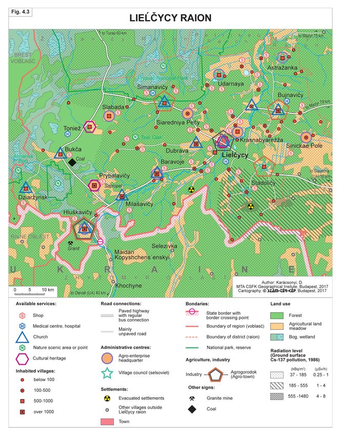
In the Soviet era, the industrialization             The post-disaster evacuation and resettle-
of what had been a peripheral area was a pri-        ment process affected altogether 350,000 people (in
ority goal. This resulted in the construction of     the period until the 1990s) (Diercke Weltatlas 2008
the Mazyr oil refinery in the first half of 1970s.   96. p). However, the various sources give widely
Further, Paliessie became a focus area for the       different numbers of people affected (492,000 –
Soviet nuclear power station construction pro-       UN 2002; 326,000 – IAEA 2006). In Belarus, the
gramme, with the site of Chernobyl NPP at            population increased in the 1980s by 30,000 people
Prypjat’ during the 1970s, and of Rivne NPP at       each year, while in consequence of the Chernobyl
Kuznetsovs’k (since 2016 renamed to Varash) in       disaster, 125,000 people were resettled in a country
the 1980s in Soviet-Ukraine.                         with a population of barely 10 million. In other

78
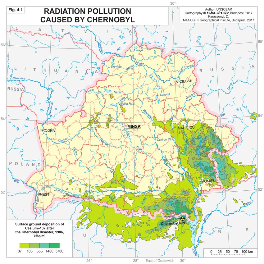
Table 4.1 Distribution of number of settlements and their population by contamination zoning (2010)

    Name of radioactive             Number of inhabited settlements/Number of          Population/urban population
      pollution zone                         inhabited urban settlements                     (thousand people)
 Immediate resettlement zone        18/0                                             3.1/ 0
                                    480/5 (Vietka, Naroŭlia, Chojniki, Čačersk,
 Resettlement zone                                                                   185.1/ 45.5
                                    Slaŭharad)
                                    904/12 (Luniniec, Mikaševičy, Buda-
 Inhabited zone of periodic
                                    Kašaliova, Homieĺ, Dobruš, Jeĺsk, Rečyca,        1,120.4/ 690.4
 radiation control
                                    Vasilievičy, Iŭje, Bychaŭ, Čavusy, Čerykaŭ)
 Total                              2,402/17                                         1,308.6/ 735.9
Source: Decree of the Council of Ministers of the Republic of Belarus of February 1, 2010 № 132 ”On Approval of
list of inhabited localities and places in the radio-active pollution zones and the admission the state of some decrees
of the Council of Ministers of the Republic of Belarus”.

words, the evacuation affected around 1.3% of the                   Chernobyl did not rewrite the regional de-
country’s total population. The corresponding fig-            mographic structures or the population dynam-
ure was 0.4% in Ukraine and 0.04% in Russia. In               ics. The decline in population would be signifi-
view of the large number of people who were re-               cant even without Chernobyl, which, however,
settled in the 1990s, the recipient regions – in par-         did accelerate the process (Karácsonyi, D. 2012).
ticular the major towns and their environs – saw              Population density was low even before the dis-
a relatively more favourable demographic trend.               aster, and the evacuations merely accentuated
The consequences of the Chernobyl disaster are                this state of affairs. The disaster did, however,
particularly apparent in the regional demographic             fundamentally alter the urbanisation processes
processes of the 1990s, but even the evacuations of           and the network of villages. Smaller agrarian vil-
the 1980s left their mark on the evacuated territo-           lages in remote areas disappeared in significant
ries (Figures 5.1, 6.8).                                      numbers, whereas small towns and minor urban
      By the 2000s, the demographic shifts had                centres became relatively more important.
subsided. Indeed, a degree of return migration is                   In Belarus, state-run companies work
also detectable. The population of several small              the arable land in the contaminated areas, us-
towns that lay in the contaminated areas but had              ing modern mechanized technology. They are
been cleaned-up [Naroŭlia, Brahin and Chojniki                careful to carry out land assessments and avoid
(Box 4.2)] began to grow once more. In marginal               micro-depressions and furrows where there is
areas that have undergone complex rehabilitation,             a risk of the isotopes undergoing enrichment
people receive significant state assistance as well           (hot spots). Rapeseed, fodder and cereal crops
as apartments. In such small towns, the presence              are grown. According to a report issued by the
of young families with small children is striking.            IAEA (2006), in the 15-year period after the dis-
New houses and apartments are built with state                aster, large number of investments were made
funding. For this reason, in the contaminated areas,          in Belarus in regions that bore the full brunt of
the population is becoming urbanized more rapid-              the accident (such investments included schools,
ly than elsewhere. Indeed, these areas have become            hospitals and social facilities).
Belarus’s “most rapidly urbanizing” regions.

           Box 4.1 Lieĺčycy district – Potential tourist region eclipsed by Chernobyl?

  Lieĺčycy district is located in the heart of Paliessie, just south of the River Prypiać and near the
  border between Belarus and Ukraine (Figure 4.3). The site of the Chernobyl disaster lies 70–80
  km to the south-east. In the north-west section, the Prypiać National Park is to be found, with its

                                                                                                                    79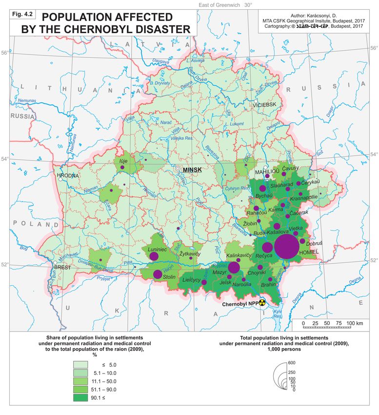
centre at Liaskavičy (Pietrykaŭ district), a popular resort. Due to this specific geographic setting
     the district has a negative outward image. Still, it possesses favourable natural features that might
     be instrumental in fighting the “Chernobyl syndrome”.
           There is just one urban settlement, the district seat of Lieĺčycy, with around 8,900 inhabit-
     ants. Otherwise, there are small villages and scattered settlements. The urbanization rate (34%)
     is well below the country’s average. Based on population density, Lieĺčycy district ranks the
     fourth sparsest in the country, after Brahin and Naroŭlia, two districts that were partially evac-
     uated after the disaster, and the traditionally scarcely inhabited Rasony, which lies close to the
     border with Russia in the north. The population density in the area was very low even prior
     to the Chernobyl disaster; it was second only to Rasony district in the census of 1979 in Soviet
     Belarus. The population of the centre Lieĺčycy grew until 1999 and then began to fall, whereas
     other settlements have long exhibited dramatic population declines.
           No major evacuation took place from the district after the Chernobyl disaster, as most of
     it lay in the zone of voluntary resettlement. Only two smaller villages, Kalinina and Baranava,
     disappeared. Owing to high radiation levels in these villages, the inhabitants had to be reset-
     tled. Subsequently, the buildings were demolished, the ruins buried, and the terrain afforested.
     Nevertheless, in 61 of the district’s 73 villages, radiation levels are significantly higher; 95% of the
     district’s inhabitants live in this area, where they are exposed to increased health risks. Most of
     the district has radiation values varying between 37 and 185 kBq/m2 due to contamination with
     Cs-137. In other words, it lies for the most part in the permanent control zone. Over large tracts
     of the district, radiation values do not exceed those in Dachstein, Austria or in some Scandinavian
     localities that are visited by thousands of tourists annually. In the south-eastern part of the dis-
     trict – nearer Chernobyl – the radiation values vary significantly. (For instance, the values are
     as high as 555–1480 kBq/m2 at the sites of the two evacuated villages mentioned above.) On the
     other hand, the accident did not affect the north-eastern portion of the district.
           Lieĺčycy district is an extremely peripheral area; it is crossed by neither a major road nor a
     railroad. The nearest urban centre is Mazyr, which lies 80 km away. To the west, there are the
     Almansk marshes, which occupy an extensive area within the Prypiać valley. Consequently, there
     is no direct traffic connection to the Brest region. Access to other districts in the Homieĺ region
     is by way of two bridges over the River Prypiać, in Turaŭ and in Mazyr. The national border
     with Ukraine lies in the south; the only crossing at Hluškavicy leads to the Ukrainian Polissia,
     an even more deprived area.
           The resources of the district’s economy are also rather poor. Mineral resources include gran-
     ite (Hluškavičy), sapropel (Prybalavičy), brown coal (Bukča) and peat. The most important raw
     material is wood and granite, however, in the lack of a rail connection they must be transported
     by road, which is more expensive.
           Forests cover two-thirds of the territory, while the cultivated area extends over barely a
     tenth of the district. The share of arable land, mainly on sandy skeletal soils, is 6%. The higher
     radiation burden has exacerbated these unfavourable agroecological conditions. Agricultural
     produce is subject to radiation controls, where the strict threshold values are somewhat higher
     than the EU standards. However, food processing is also a major aspect of the economy. Forest
     produce that is very sensitive to radiation, such as mushrooms and berries (raspberry, blueberry,
     and cranberry), have considerable economic importance. A forest management company has a
     newly (2006) established cranberry plantation on 10 hectares near Lieĺčycy; the annual yield is
     20 tonnes of fruit.
           Arable land is used to produce rye, rape, buckwheat and fodder crops. Special types of
     buckwheat are planted to reduce soil radioactivity. Radioactive isotopes are mainly stored in
     the green parts of the plant and to a lesser extent in the seeds from which biodiesel is made.
     Accordingly, the green parts need to be separated and stored – a costly operation. Potatoes and
     vegetables are chiefly grown in household gardens, even though the soil has not been replaced

80
81
since the Chernobyl accident. Animal products have considerable importance for the economy,
especially milk and butter production. The Kalinkavičy dairy plant maintains a subsidiary at
Lieĺčycy, and the sector enjoyed generous state subsidies in 2007–2008. Altogether there are ten
farming cooperatives in the district, and the largest agricultural machine and service station adds
to the meagre industry of the district centre.
The service sector has been given a fresh impetus especially in the district seat, where bank
branches, a post office, a hotel and several schools operate alongside a number of retail stores.
In addition to business services, there are – similarly to elsewhere in the country – relatively
well-developed social, cultural and health services. The town also hosts several libraries and
cultural centres. Cultural and sport events – folk dance, vintage, harvest and patronal festivals
– are held regularly, and performances by groups are organized at the house of culture. Rather
than attract foreign tourists, such events meet the cultural and sport requirements of local people.
In this sense, they differ from similar events in Western Europe.
The development of rural tourism has recently come to the fore; it is viewed as a pos-
sible remedy for the problems facing rural areas in Belarus. Several private ventures have
been launched. At Svidnoe village, a large tourist centre was established using private capital.
Foreign investors have not contributed, and to date few foreign tourists have come to the cen-
tre. Conditions are favourable for angling and hunting. Still, the area’s negative image hinders
progress in the tourism sector, and the training of experts in tourism has not even started yet.
Housing construction, mainly undertaken by the state, is concentrated in the district cen-
tre and four designated agrogorodoks (former villages developed into agrarian townships, see
Box 6.2): for instance, in Stadoličy, Milašavicy. High-rise buildings for young people are under
construction in the former, whereas in the latter, uniform detached houses (with small gardens)
are typically being constructed. They are being targeted at younger people who have decided
to move to a rural area. Even though employment opportunities are abundant, there are many
vacant apartments and small houses. This calls into question the wisdom of central government
funding for these projects.
In spite of the considerable distances, the public transport connections of the district and the
frequency of services along the main routes are adequate and far better than the norm in Ukraine
or Russia. Road surfaces are satisfactory; many minor streets are paved even in tiny villages. This
protects against radiation, as such roads are not so dusty.
As a major part of the district lies in the permanent control zone, there is a relatively devel-
oped system of health services. Lieĺčycy has its own hospital. The inhabitants of the settlements
affected by radiation receive a thorough medical examination every year. The residents of the rela-
tively contaminated settlements receive medicines at subsidized prices or free of charge. Regional
programmes are supported by the state and by the United Nations. Special medical-ecological
courses are held in schools, educating young people about how to deal with the consequences
of the accident and how to avoid health risks.
Camps for Chernobyl children are organized each year in ecologically clean areas, frequent-
ly at foreign invitation (in Germany, Great Britain, Ireland, Italy, Spain, and even in Canada).
Children participating in such initiatives often live with local families, and many friendships
have been established over the years. This has contributed to raising the children in a healthier
environment and mitigating the negative image of the region in the media.
Despite the problems, the local population looks to the future with optimism. People feel a
sense of social security in view of generous state support. On the other hand, they have become
resigned to the consequences of the accident; they are either indifferent to or sceptical about the
“invisible” radioactive contamination. This is clearly a psychological reaction: people are eager
to learn what the future holds. They wish to put their troubles behind them, having grown tired
of the problems of the last quarter of a century. (The text based on several interviews with the
local authorities and people between 2007 and 2011.)
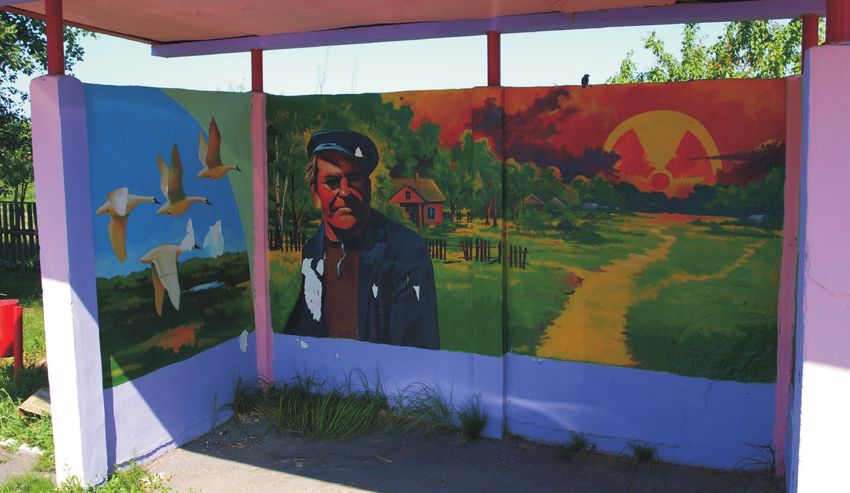
82Painting in a bus stop near Chojniki town. The Chernobyl disaster radically changed the traditional Paliessian
region, erasing dozens of small villages from the map. (Photo: Karácsonyi, D. 2010)
Traditional wooden blockhouse in a Polessian village – Lieĺčycy district. (Photo: Karácsonyi, D. 2015)
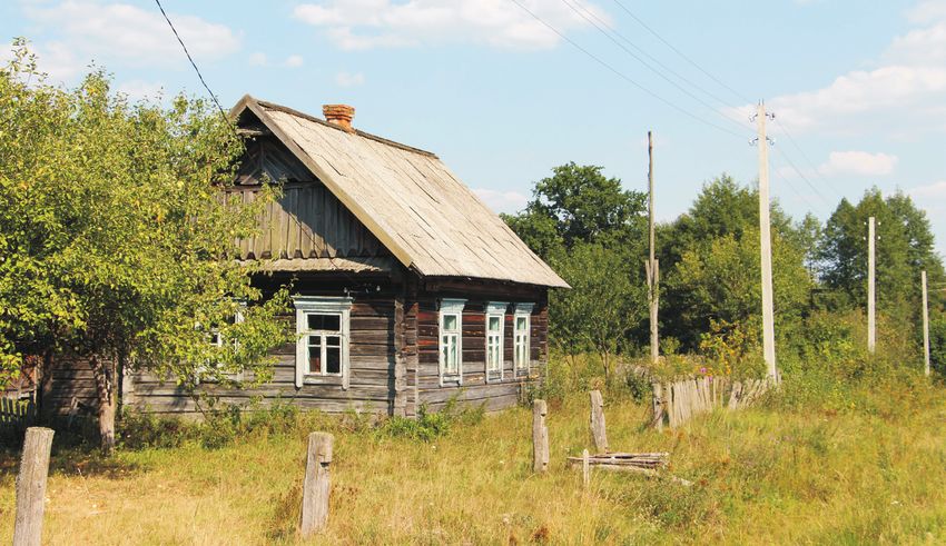
83Box 4.2 Chojniki district – Evacuation waves and changing settlement patterns after
Chernobyl
Chojniki district, which lies near the Chernobyl NPP on the Belarusian side of the border, is one of
the most affected administrative districts in Belarus, both in terms of the extent of the contaminated
areas and in terms of the share of the population affected (Table 4.2). At least half of the district lies
in the evacuation zone, from which around 20,000 people were resettled in the first six to seven
years after the disaster. Between 1979 and 1999, the district lost almost 60% of its population, and
so, together with the neighbouring Brahin district, the effect of the accident in terms of population
decline was greater here than anywhere else in Belarus. More than two-thirds of the rural popu-
lation disappeared, and the network of villages – with the exception of villages in the environs of
Chojniki and to the north of the town – was almost completely abandoned (Figure 4.4).
The Chernobyl Tragedy Museum in Chojniki has preserved, thanks to the efforts of local
historians, a list of the names of evacuees as well as the exact population data for the various set-
tlements in the district. The data, which cover the two decades after the disaster, were collected
by a team of Japanese and Hungarian researchers in the summer of 2015. Subsequently, the entire
database was digitalised. To our knowledge, no other district in Belarus disposes of such detailed
population data and post-Chernobyl evacuation records.
The yearly changes in the rural population figures reflect the various waves of evacuation
and resettlement. First, 8,000 people were required to leave their homes in 1986, being evacuated
from the part of the district that lay in the evacuation zone. After independence, in the course of
1991–1992, they were followed by a further 8–10,000 evacuees from outside the evacuation zone.
This resettlement wave coincided with the resettlement of people from highly contaminated set-
tlements that lay near Vietka, Čačersk and Slaŭharad, at a greater distance from the evacuation
zone designated in 1986.
Chojniki district’s situation reflects the altered settlement patterns seen in similar districts after
the evacuations. Whereas the smaller peripheral villages, which were inhabited mostly by older
people, could be evacuated quickly and relatively cheaply, the evacuation of the larger villages and
towns never took place. As a result, a substantial spatial concentration occurred, mainly to the ben-
efit of urban settlements. This “caused” a rapid increase in the urbanization rate in these districts.
Moreover, some of the people designated for resettlement did not leave the district but settled in
the district centres, which were not subsequently evacuated. These district centres have been the
exclusive target areas for recent population inflows, which are promoted in part by state subsidies.
Table 4.2 Change of population of raions most affected by the Chernobyl disaster (1979–2000)
Total Total Urban Rural Ratio of contaminated
Raion Country population population population population area by Cs-137 % over
loss % loss persons loss % loss % 0.25, 1 and 4 µSv/h (1986)
Polisske Ukraine –80 –29,748 –100 –69 70, 51, 27
Narodichi Ukraine –64 –20,554 –58 –66 96, 28, 23
Brahin Belarus –61 –27,365 –26 –69 100, 56, 30
Chojniki Belarus –57 –24,476 –1 –68 100, 79, 57*
Vetka Belarus –52 –22,812 –11 –62 100, 97, 63
Naroŭlja Belarus –48 –16,449 –13 –75 100, 94, 47
Ivankiv Ukraine –46 –50,251 –17 –63 100, 28, 19
Novozubkov Russia –32 –26,327 –16 –56 100, 100, 76
*31% of the total area of Chojniki raion was over 8 µSv/h in 1986.
Source: Regional statistical yearbooks of Belarus, Ukraine and Russia and author’s own calculation.
8485
You can also read