Vulnerability of society on earthquake disasters in kayangan north lombok - IOPscience
←
→
Page content transcription
If your browser does not render page correctly, please read the page content below

IOP Conference Series: Earth and Environmental Science

PAPER • OPEN ACCESS

Vulnerability of society on earthquake disasters in kayangan north
lombok
To cite this article: M H Wulan et al 2021 IOP Conf. Ser.: Earth Environ. Sci. 683 012077

View the article online for updates and enhancements.

                               This content was downloaded from IP address 46.4.80.155 on 09/08/2021 at 20:37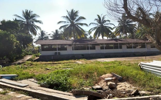
International Geography Seminar 2019                                                                           IOP Publishing
IOP Conf. Series: Earth and Environmental Science 683 (2021) 012077                        doi:10.1088/1755-1315/683/1/012077

Vulnerability of society on earthquake disasters in kayangan
north lombok

                     M H Wulan*, Nurhadi, C Muryani
                     Geography Education, Sebelas Maret University, Surakarta
                     *hemiwm@gmail.com

                      Abstract. The earthquake caused severe damage in North Lombok Regency. The impact of the
                      earthquake was that there were many casualties and most of the residents' houses suffered minor
                      to severe damage and caused damage to public facilities available. Kayangan Subdistrict is one
                      of five sub-districts located in North Lombok Regency and has the worst damage. This study
                      aims to analyze the level of vulnerability of the community in Kayangan Subdistrict. The
                      technique of collecting data is by observing, documenting, and interviewing relevant offices and
                      stakeholders in Kayangan Subdistrict. Data analysis using qualitative descriptive. The results of
                      this study show that the categories of household vulnerability in Kayangan Subdistrict can be
                      divided into three groups, namely, among others: (1) Prosperous Groups, (2) Middle Groups,
                      and (3) Poor Groups. Whereas when viewed from vulnerable age groups in Kayangan
                      Subdistrict, the productive age group is more vulnerable when compared to the unproductive
                      age group and the unproductive age group. The productive age group includes women and men
                      aged between 15-64 years. In addition, if viewed from the socio-economic aspects this is very
                      closely related to vulnerability analysis. When viewed from the socio-economic capital of the
                      population in Kayangan Subdistrict, it has very good social and economic capital in meeting its
                      needs after an earthquake. This greatly helps the community in fulfilling its life so that it can
                      reduce socio-economic vulnerability in society. In addition, the role of the government in
                      providing assistance in the form of earthquake resistant housing options also greatly helped the
                      community in the recovery period following the earthquake.

1. Introduction
Earthquakes are a threat since hundreds of years ago and often occur in developing countries such as
Indonesia[1]. The territory of Indonesia is located on three tectonic plates of the world, namely the Indo-
Australian plate, Eurasia and the Pacific plate and is a path that is passed by The Pacific Ring of Fire or
the Ring of the Pacific Fire [2]. The history of earthquakes in Indonesia is quite long, Indonesia is located
in the lane of the earthquake that stretches not less than 5,600 km, starting from Andaman to the East
Banda arc so that it is an area prone to earthquakes [4]. The three plate zones contribute to 90% of
earthquakes and are dominated by large categories of earthquakes [5]. Based on data from BNPB there
has been an earthquake in more than a decade that occurred in Indonesia. BNPB data recorded that 191
earthquakes occurred from 2009 to 2019, whether large or small scale that could be detected.
Earthquakes cause many casualties and damage to homes and public facilities. So far, during the past
decade, BNPB recorded a total of 2,093 dead, 10,701 injured, and 958,568 victims displaced. In
addition, there were 288,140 heavily damaged houses, 49,317 units were damaged and 491,591 units
were slightly damaged. The earthquake not only caused many casualties and damage to homes, but also
damaged public facilities including damage to health facilities by 1,050 units, worship facilities 10,559
units and educational facilities as many as 13,699 units.

              Content from this work may be used under the terms of the Creative Commons Attribution 3.0 licence. Any further distribution
              of this work must maintain attribution to the author(s) and the title of the work, journal citation and DOI.
Published under licence by IOP Publishing Ltd                          1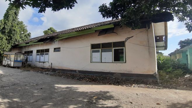
International Geography Seminar 2019                                                                      IOP Publishing
IOP Conf. Series: Earth and Environmental Science 683 (2021) 012077                   doi:10.1088/1755-1315/683/1/012077

                                         Trend Chart of Earthquake Disasters in the Last 10 Years
                                                              in Indonesia
                                    30
                 Number of events

                                    25
                                    20
                                    15
                                    10
                                     5
                                    0
                                          2009 2010 2011 2012 2013 2014 2015 2016 2017 2018
           Figure 1. Trend Chart of Earthquake Disasters in the Last 10 Years in Indonesia
                           Source: National Disaster Management Agency

   One of the earthquake prone areas is West Nusa Tenggara Province [3]. West Nusa Tenggara is an
area that is traversed by the Mediterranean route, so that in this region frequent tectonic and volcanic
earthquakes [5]. This province consists of Lombok Island and Sumbawa Island. Geologically, West
Nusa Tenggara Province is an active seismic region so that this region has the potential for an earthquake
because it is located between two earthquake generators, namely from the south and north [6].
Earthquakes can become disasters if they occur in areas of human occupancy and cause potential losses
and become a barrier to the occurrence of economic and social activities. Hazardous natural activities
can turn into disasters if these humans do not have strong resistance to deal with them [7]. Disaster
management that was previously more focused on post-disaster handling needs to be diverted for
vulnerability reduction and capacity building activities [8].
   The earthquake that occurred in Lombok in August 2018 identified the still not optimal integration of
disaster risk analysis into regional development planning. Therefore, this caused serious damage in
North Lombok Regency. The impact of the earthquake was a lot of casualties and most of the residents'
homes suffered minor to severe damage and caused damage to the available infrastructure. Visual data
shows that most of the damage occurs in built-up environments that develop following the economic,
infrastructure and tourism development process.
   Kayangan Sub district is one of five sub-districts that suffered the worst damage. Based on data
recorded by the North Lombok Regional Disaster Management Agency, the number of victims who died
in this sub-district was 175 people, 53 people were seriously injured and minor injuries were 195 people.
In addition, there is also damage to the education infrastructure including school damage from the level
of PAUD/TK (kindergarten), SD/MI (elementary level), SMP/MTS (junior high school), and SMA/MA
(senior high school) which is as many as 80 units. Other damage is in the infrastructure of places of
worship, namely as many as 55 units consisting of mosques, prayer rooms and temples. Society as a
group of individuals with different characteristics tends to be pragmatic by considering disasters as an
unavoidable destiny and prefer to be resigned [9]. Therefore, this is also one of the causes of the many
fatalities in Kayangan Sub district.
      Based on the results of a review of research conducted by other researchers regarding community
vulnerability and earthquake disasters, the study was conducted by [10] with the research title "Disaster
based earthquake assessment on the catastrophe progression method: A Sichuan Province case study".
This study focuses on assessing the social vulnerability of earthquake disasters in Sichuan Province,
China based on the method of disaster development established. The results of this study indicate that
the northeast and central regions of Sichuan Province have a high category of social vulnerability;
especially Guangyun is the most vulnerable region. These findings will provide a basic scientific policy
for policy makers to create disaster risk management strategies for them. Furthermore, the research was
conducted by [11] with the research title, "Profiling Informal Settlements for Disaster Risk". The

                                                                     2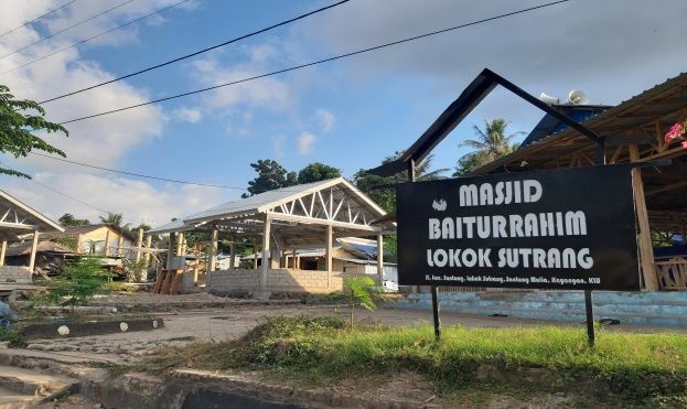
International Geography Seminar 2019                                                       IOP Publishing
IOP Conf. Series: Earth and Environmental Science 683 (2021) 012077    doi:10.1088/1755-1315/683/1/012077

purpose of this study is to develop a theoretical framework through a literature review that combines the
concepts of "disaster hazard", "vulnerability" and "informal settlement". The results of this study, which
show that environmental policies (environment/land use planning and communication) have an impact
on informal settlement characteristics (demographic, financial, social, and location/environment) are
key to managing disaster risk profiles in informal settlements, as well as identifying five theoretical
propositions who can help in disaster preparedness.
      Research conducted by [12] with the research title "Anticipated behavioral response patterns to
earthquake: The role of personal and household characteristics, risk perception, previous experience and
preparedness". The purpose of this study is to survey expected behavioral strategies among residents of
high vulnerability risk areas in Israel and assess factors that can influence their behavior. The results
show that people with low socioeconomic status are more vulnerable. Some personal and socio-
economic characteristics are associated with behavior expected by citizens. The level of preparedness
and type of earthquake occupancy are significant predictors of recommended behavioral strategy
choices. The implications of these results and possible ways to improve readiness are discussed. In
addition, other studies are conducted by [13] entitled "Household Identification of Earthquake Prone
Hazards in the Bantul Regency Area in Yogyakarta" which focuses on the impact of disasters in Bantul
Yogyakarta disaster prone areas using the Sustainable Livelihood (SLA) method. The conclusion of this
study is that there are three (1) richest people who suffer the least amount of disasters because of their
ability to reduce the impact of disasters by strengthening their homes and using their assets, (2) suffering
makes poor people able to reduce the impact of disasters in the future the front for its survival by
maximizing social capital so as to minimize the costs of building houses and (3) the survival groups are
the most vulnerable to catastrophic events because their wealth has run out for reconstruction costs and
their inability to reduce labor costs. The last research is research conducted by [14] entitled "Marginality
and vulnerability". This study focuses on exploring the value of adding data on social marginality to the
model of the impact of the Japanese earthquake and incorporating marginalized groups into the disaster
planning process. The phenomenon of the growth of homelessness in Tokyo was used as a test. It is said
that data on homelessness will improve the performance of systems designed to enhance personal and
social protection, while the incorporation of marginal city groups will utilize new knowledge about
coping mechanisms and enrich the entire planning process.
   Disaster risk occurs due to a meeting between threats/hazards with vulnerability factors and capacity
factors. Social perspective sciences take into account various factors and parameters that affect
vulnerability, such as physical, economic, social, environmental, and institutional characteristics. In
addition, in fact since ancient times in this area have known earthquake resistant houses. This can be
seen from the remains of traditional houses that are still left. Previous ancestors built houses by
considering natural conditions. Other factors, as well as the progress of the times and the development
of technology, there has been a shift in the mindset of the community so that many houses were created
that were traditionally modern, even though people in the area knew that the area was prone to
earthquakes. Therefore, this is also one of the causes of community vulnerability in the face of
earthquake disasters that occur in their area. This study aims to analyze the vulnerability of the
community to earthquake risk in Kayangan Sub district, North Lombok.

2. Methods
This research is a qualitative descriptive study (data presentation, data reduction, and conclusions) using
a spatial approach. The population in this study were all residents living in Kayangan Sub district.
Sampling in this study is by using Purposive sampling. The sample used in this study was 60 households
taken from each village with the criteria taken based on the 4 villages most affected by the earthquake
disaster. Data collection can be carried out with various settings, various sources, and various ways.
Data collection techniques in this study used observation, documentation, and interviews. Qualitatively,
the data is collected through in-depth interviews with stakeholders related to disaster issues in the North
Lombok region. The data analysis used in this study is using qualitative descriptive.

                                                     3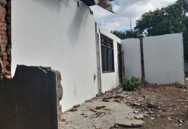
International Geography Seminar 2019                                                       IOP Publishing
IOP Conf. Series: Earth and Environmental Science 683 (2021) 012077    doi:10.1088/1755-1315/683/1/012077

3. Results and Discussion
When viewed from its history, actually in 1979 an earthquake had occurred, especially in the North
West Lombok region. At that time the majority of the people's dwellings still used traditional buildings,
namely with bamboo poles and roofs from reeds. Therefore, the earthquake that occurred at that time
did not cause many casualties and damage to houses would also be available public facilities. The
absence of a program on disaster mitigation by the government so that many people do not understand
about saving themselves during a sudden earthquake. Many people forget the events of the earthquake
that occurred 40 years ago. In contrast to the current conditions, most of the people in Kayangan Sub
district, North Lombok, are shifting from traditional stage houses to modern houses made of bricks,
cement and other heavy materials. Then when the earthquake occurred in August 2018 there were many
casualties and damage to existing houses and public facilities. The government has not yet thought about
disaster mitigation for North Lombok Regency. Disaster Mitigation made by the new Government in
2007. Before, government policies made before 2007 were more towards emergency response. They
think about how the state provides assistance to victims of the earthquake. Then in 2007 the government
began directing policies in the direction of disaster in order to reduce the risk of earthquake disasters in
North Lombok Regency so that it could be used as a guideline up to the regional level.

3.1. Research Sites
This research was conducted in Kayangan Sub district located in North Lombok Regency.
Astronomically Kayangan Sub district is located at 08 ° 15,657 7'S - 116 ° 15, 6608’E. This sub district
has a regional boundary, namely: the north bordering the Java Sea, on the east bordering on Bayan
District, on the south bordering West Lombok Regency, and on the west bordering the Gangga District.
The area of Kayangan District is 112.90 km². The sub-district has 8 villages, among others: Santong
Village, Pendua Village, Kayangan Village, Dangiang Village, Sesait Village, Gumantar Village,
Selengen Village, and Salut Village. Kayangan Subdistrict is one of the sub-districts in North Lombok
Regency which suffered the worst damage and most victims due to the earthquake disaster. The villages
most affected by the earthquake were Santong Village, Kayangan Village, Dangiang Village, and
Gumantar Village. Therefore, the researchers took the four villages as research locations in Kayangan
Sub district.
              Table 1. Population, Area, and Population Density in Kayangan Subdistrict
         Number        village name    Total population     An Area          Population Density
                                           (people)          (km²)             (people / km²)
           1.         Santong                6138             8,80                  698
           2.         Pendua                 2205             5,14                  429
           3.         Kayangan               5496            11,40                  482
           4.         Dangiang               2963             3,46                  856
           5.         Sesait                 8597            17,10                  503
           6.         Gumantar               5697            38,60                  148
           7.         Selengen               5551            19,50                  285
           8.         Salut                  3447             8,90                  387
                      Jumlah                40.094          112,90                  355
                  Source: (Badan Pusat Statistik Kabupaten Lombok Utara, 2017)
    Demographically Kayangan Sub district is a densely populated sub-district. The total population in
this sub-district is 40,094 people. Based on the sex in this Sub district, the number of women is more
than the male population, which is the difference of 792 people. Based on data from [15], it can be seen
in Kayangan Sub district which is the most densely populated namely Sesait Village, which is as many
as 8,597 people and the least populous is Pendua Village which is 2,205 people. Based on data from
census results by the Central Bureau of Statistics in 2010, 2015, 2017, and 2018 the population density
in Kayangan sub-district has increased between 2010 and 2015, which initially was 331 people / km²
and the density became 394 people / km². Furthermore, in 2017 the population density in this region has

                                                     4
International Geography Seminar 2019 IOP Publishing
IOP Conf. Series: Earth and Environmental Science 683 (2021) 012077 doi:10.1088/1755-1315/683/1/012077
decreased which is to be 355 people / km² and in 2018 the population density is still the same as the
previous year.
The livelihoods of residents in Kayangan Sub district mostly work as planters and farmers. There are
some of them who work as construction workers, fishermen, and entrepreneurs. In addition, when
viewed from land use in Kayangan Sub district can be divided into 4 types, among others: paddy fields,
dry land, yards and other land uses. The majority of land use in this sub-district is used as dry land,
which is 6,235 Ha and paddy land area is 2,733 Ha.
3.2. Post-Earthquake Conditions in Kayangan Sub district
The earthquake that hit the Kayangan District of North Lombok Regency in August 2018 has proven
that the vulnerability of the northern part of Lombok and its surroundings to the threat of an earthquake.
The condition of the Kayangan Sub-District after the earthquake was devastated up to now 6 months
after the earthquake struck. There are still many houses that have been destroyed and have not been
repaired due to the earthquake. The latest North Lombok BPBD data as of March 31, 2019 has recorded
that there were 53,477 houses included in the category of severe damage, 7,086 houses in the medium
damaged category, and as many as 15,117 houses in the slightly damaged category. In addition there are
also many public facilities that were destroyed and then made temporary public facilities such as schools,
places of worship, health centers, government offices, public toilets, and so on. The condition of road
infrastructure after the earthquake broke out on provincial roads and on local roads and there were
several bridges damaged by the earthquake. Overall for roads and bridges only minor damage occurs
such as cracks but nothing has been broken due to an earthquake. Based on the recapitulation of data
from the North Lombok Regency BPBD for the Kayangan Sub district itself there are a number of
damaged public facilities, namely schools from the level of PAUD/TK to the high school/MA level of
80 units. In addition to the damage to places of worship due to the earthquake disaster, namely 21 units
of the mosque were severely damaged, 29 units of prayer rooms were severely damaged, and 5 units of
the temple were also heavily damaged. After the earthquake occurred, many refugee camps were
erected. The point of self-evacuation in Kayangan Sub district was 108 refugee points scattered in each
village and accommodating as many as 8,625 households with a population of 33,087 people.
Figure 1. Damage to Houses in Kayangan Figure 2. Damage to School in Kayangan
5International Geography Seminar 2019 IOP Publishing
IOP Conf. Series: Earth and Environmental Science 683 (2021) 012077 doi:10.1088/1755-1315/683/1/012077
Figure 3. Damage to the village office in Kayangan Figure 4. Damage to the Mosque in Kayangan
3.3 Vulnerability category in Kayangan Sub district
This article departs from a concept developed by a number of social scientists that the magnitude of the
impact of disasters is caused by high vulnerability and that vulnerability is a product of interactions
between natural conditions and human activities [16]. Based on the survey conducted on ownership,
access, and life capital assets (human, natural, financial / economic, physical and social), it can be
analyzed into 3 categories of vulnerability of households, namely the affluent, middle and poor. When
data obtained from research is combined with studies conducted in the PRA, categories can be obtained
that can represent the conditions of each group, namely gadhah (possession), stress (adequacy), and
confusion (poor) [13].
3.4 Prosperous Group
The affluent group is those who belong to the wealthiest group in the village consisting of people who
have life capital assets (human, natural, economic, physical and social) that are good for fulfilling their
daily needs. Included in this group are civil servants, and government employees. Based on research
data this group has characteristics including: highly educated, has extensive knowledge and insight, does
not have a history of severe illness even if they have the disease able to finance treatment without having
to shake the stability of the household economy, able to meet the needs of daily living with enough,
owning a vehicle in the form of a motorbike or car as a means of transportation, owning a house that is
strong in structure and resistant to earthquake shocks, has extensive land ownership, has high income
and sufficient savings to fulfill long-term life and urgent needs, and occupying an important position
socially, having a broad and strong social network both inside and outside the region.
3.4.1 Middle Group
The middle class is a household group that has relatively far adrift conditions with the affluent group.
Included in this group are livestock traders, agricultural commodity intermediary traders, small shop
owners or small shops. The limited work in the village has caused them to choose non-agricultural jobs.
This group consists of people who have life capital assets (human, natural, economic, physical and
social) that are sufficient to meet their daily needs. Based on research data, this group has characteristics
including: having a sufficient standard house to live in, having uncertain income and depending on
market conditions, there is only a very small portion of the income that can be saved. Access to modern
banking services is limited to short-term deposits. Savings to fulfill short-term life and follow
organizations in their area as members. When needing large funds that cannot be reached by regular
income, most of them choose to borrow funds in cooperatives or moneylenders. Meeting other needs
for health insurance and strengthening the structure of home buildings tend to be ignored. Whereas if
they have critical illness or suffer from illness most of them choose outpatient treatment with
consideration of more affordable funds. When there is an emergency situation and requires large
6International Geography Seminar 2019 IOP Publishing
IOP Conf. Series: Earth and Environmental Science 683 (2021) 012077 doi:10.1088/1755-1315/683/1/012077
expenditure this group has the potential to experience bankruptcy and it is difficult to recover to a normal
life.
3.4.2 Poor Groups
The Poor Group is a household group that has the lowest strata in the community. Included in this group
are households that usually depend on irregular and irregular daily income including construction
workers, farm laborers, drivers and small fishermen. Some of their income is used to meet daily food
needs, electricity bills, and other necessities of life. Most of them do not take high school or even junior
high school education. On average, they only finished their education to elementary school. In addition
to low education, lack of adequate skills makes it difficult for them to get jobs in the formal sector or
clear non-formal work. They are not able to build a decent house and are resistant to earthquake shocks.
In addition, they also do not have adequate transportation. Health costs are not something that is too
worrying because there is assistance from the government in the form of KIS (Healthy Indonesia Cards).
In addition, for those who have school-age children, most of them go to school by relying on government
assistance in the form of KIP (Smart Indonesian Card) while most households that do not have a
guarantee card from the government choose to send their children to elementary school or even not
going to school.
3.4.3 Vulnerable Age Group
Following is the data on the number of deaths in Kayangan Sub district as shown in Table 2 as follows.
Based on data on the number of deaths in Kayangan Subdistrict as shown in Table 1, it can be analyzed
that when viewed from the age of the population vulnerable to earthquakes in Kayangan Sub district,
North Lombok Regency, the productive age group is more vulnerable than the non-productive age group
and the age group. Not productive. The productive age group includes women and men aged between
15-64 years. Men who belong to the productive age group can be vulnerable after natural disasters can
be caused by loss of residence, social environment conditions, sources of income, loss of employment,
reduced savings to meet daily basic needs, besides when they have to evacuate to a place far away and
full of uncertainty for a long time.
Table 2. Number of Death Victims in Kayangan Subdistrict
Number Village Not Productive Productive Age No Productive
(people) (people) (people)
1. Gumantar 14 22 8
2. Dangiang 3 8 5
3. Sesait 12 16 1
4. Kayangan 3 10 6
5. Pendua 1 2 0
6. Selengan 10 17 10
7. Santong 1 8 3
8. Salut 1 7 7
Jumlah 45 90 40
Source: Secondary Data, 2019
Women who belong to this productive age are vulnerable due to the social construction of the
people who shape them. In addition, this is because women lack access to resources in the form of social
networks and the influence of transportation, information, expertise, literacy rates, control of agricultural
land and economic resources, healthy housing and freedom from violence, and control over policy
making. Furthermore, women are victims of segregation of labor based on sex and generally the amount
is excessive in the agricultural sector, household, and the informal economy which earns under-standard
income with little security and lack of health facilities from the union. Viewed from the agricultural
sector and the informal economy generally suffers the greatest losses after the disaster, it results in
7International Geography Seminar 2019 IOP Publishing
IOP Conf. Series: Earth and Environmental Science 683 (2021) 012077 doi:10.1088/1755-1315/683/1/012077
women who are in excess quantity in this sector losing their source of income. In addition, women whose
homes have been damaged by the earthquake and who have to live in refugee camps, still have to endure
household chores such as taking care of children, elderly people and disabled people so that they lose
their freedom to seek new livelihoods.
Unproductive age groups, namely children aged 0-14 years are part of vulnerable groups after the
earthquake, which is due to various conditions, among others, many children experience physical
injuries, psychological trauma, disease attacks, and malnutrition. In addition, children are still dependent
on parents so they still need adult support to survive. Children are also still in the age of growth so that
in its growth is very dependent on adults or parents.
Elderly people who are also part of the unproductive age group, aged 64 years and older, become
a vulnerable group after an earthquake, this is caused by various situations. One of them is the majority
of the elderly population are often late to register themselves in the handling program after the
earthquake disaster. Whereas among them when they are registered, they are often unable to participate
in programs or activities held by the government. In addition, the elderly also often experience acute
malnutrition, weak physical conditions, forget to take the medicine, some of them experience physical
and psychological stress from family members who are also victims of the earthquake. Other factors,
namely the elderly also experienced delays in restoring their economic conditions, escaped the attention
of their social environment, were less responsive to warnings of disasters, so that most of them had
difficulty being able to survive after an earthquake.
3.5 Identification of Vulnerable Earthquake Disaster Groups from the Socio-Economic Aspect
Socio-economic aspects are very closely related to vulnerability analysis. Vulnerability is the inability
of an individual or community group to anticipate, cope with, maintain, and save themselves or groups
against the effects caused by a natural hazard. Based on the results of research in Kayangan Sub district,
North Lombok Regency, there are Sasak tribes who live in areas bordering natural forest, far from the
area which is the center of government and the market economic system. Openness of North Lombok
Regency as a center of culture Indonesia makes this region an area that has a strong network both at
national and international levels. When a disaster occurs, the social capital owned by the community
changes to financial assistance and other forms, both from national organizations and from international
organizations. In addition, at the community level, relations between community members are very
strong, namely they still instill the value of mutual cooperation and strong kinship relations between
neighbors. Many family heads reside more than 30 years and this shows if they are born in the same
village and they have strong kinship in dealing with the problems that occur. In addition, there are some
people from other regions, such as, East Lombok, West Lombok and Bali.
Many communities in the study area come from various kinds of community and institutional
organizations including: BPD (Village Management Board), LPM, Karang Taruna, PKK (Family
Welfare Empowerment), P3A, GAPOKTAN, BUMDES, Fishermen Groups and POKLAHSAR
(Marine Products Management) , LKS Friends Sharing, BARNAS PD, PERANTA, FKP LOPANDA,
BAJANG MANDIRI, GARDA, CREATIVE ANSES, KOMPAK, OBSESKA, SORAK SIU
Association (SEMETIAN PEPADU Association), KWT (Farmer Women Group), KUM (Mandiri
Business Group, Livestock Farmers Group For example, each household has a different institution,
namely one household and the other is a part of the neighboring neighborhoods, community groups and
different hamlets, each of which has a different program for the prosperity of its people. this institution
also facilitates relations between the community and the government, through community and
institutional organizations that are very helpful for the community in searching and get help when it
happens in an emergency. Therefore, this community organization provides a very important role for
the community.
If viewed from the economic point of view of the community, the research area is dominated by
the natural sector. This can be seen from the majority of the livelihoods owned by the community. The
majority of people living in their highlands have livelihoods, namely in agriculture, namely gardening.
8International Geography Seminar 2019 IOP Publishing
IOP Conf. Series: Earth and Environmental Science 683 (2021) 012077 doi:10.1088/1755-1315/683/1/012077
The majority of plantation crops planted are coconut, cashew, coffee and banana. Whereas the majority
of people living in their lowland areas have a livelihood as farmers, some become fishermen,
construction workers and entrepreneurs. Agricultural crops commonly planted by residents include rice,
corn, peanuts, chili, and long beans. In addition, the majority of the population has deposits in the form
of chickens, goats, and cows. When viewed from the perspective of rural households, they have been
able to make various kinds of livelihoods by selling products from their farms or just to fulfill their daily
needs. Many of the study respondents reported that after the earthquake they did not sell their produce
and farms but instead they relied on these products to meet basic food needs during an emergency.
Among them were sharing agricultural produce during an emergency after an earthquake occurred to
fulfill survival. Therefore, they not only rely on government assistance, but they rely on the results of
the gardens and farms they have. This greatly helps the community in fulfilling its life so that it can
reduce economic vulnerability in society.
The impact of the earthquake in August 2018 was felt differently by each household group, but
there was one impact felt by almost all households, namely damage to houses and infrastructure and
public facilities. 90% of homes in Kayangan Sub district have been severely damaged and even very
few houses can still stand firm after the earthquake occurred. Some destroyed houses are made of
construction made of bricks, cement, concrete blocks and other heavy materials. This caused a lot of
damage and many victims were crushed by the ruins of their own house. In addition, the collapsed walls
and the destroyed roof mostly hit household furniture, electronic equipment, vehicles so that many were
damaged by the earthquake. When viewed from the category of vulnerability of household groups
suffered and the losses experienced by the rich group are fewer when compared to the middle and poor
groups. The high level of economic welfare, high human capital, and good social capital, as well as
owning houses with earthquake resistant structures make them able to effectively reduce the risk of the
effects of earthquakes. In addition, the greatest losses were experienced by the poor because many of
them lost their livelihoods and did not work for months due to earthquakes. Some of them report feeling
traumatized and afraid when they have to find work. Even though it is disadvantaged groups of poor
people can also get a number of benefits after the disaster, especially when entering the phase of housing
reconstruction. Many of them get assistance from the government in the form of earthquake resistant
houses so that they will automatically be greatly helped in this matter. In addition to earthquake resistant
houses, other assistance they have also received in the form of food, clothing, money, and medicines
has helped them to continue their lives after the earthquake. The middle class experiences the worst
situation because of the lack of life capital (human, natural, financial / economic, physical and social)
that they have. In addition, this group does not have the social security provided by the state not reaching
this group so that they have to make ends meet after the earthquake by using their own capital assets to
reduce the risk of emergencies.
4. Conclusion
The category of vulnerability of households in Kayangan Sub district can be divided into three groups,
namely, among others: (1) Prosperous Groups, (2) Middle Groups, and (3) Poor Groups. Whereas when
viewed from vulnerable age groups in Kayangan Sub district, the productive age group is more
vulnerable when compared to the unproductive age group and the unproductive age group. The
productive age group includes women and men aged between 15-64 years. In addition, if viewed from
the socio-economic aspects this is very closely related to vulnerability analysis. When viewed from the
socio-economic capital of the population in Kayangan Sub district, it has very good social and economic
capital in meeting its needs after an earthquake. This greatly helps the community in fulfilling its life so
that it can reduce socio-economic vulnerability in society. In addition, the role of the government in
providing assistance in the form of earthquake resistant housing options also greatly helped the
community in the recovery period following the earthquake
9International Geography Seminar 2019 IOP Publishing
IOP Conf. Series: Earth and Environmental Science 683 (2021) 012077 doi:10.1088/1755-1315/683/1/012077
Acknowledgments
The author expresses his gratitude to Kementistekdikti as a research institute who has collaborated in
this Master’s Thesis Research, Mr. Dr.rer.nat. Nurhadi, S.Ant, M.Hum, as Counselor I, and Mrs. Prof.
Dr. Chatarina Muryani, M.Sc, as Counselor II, who always provides motivation, guidance and direction
in completing this research. Thank you to BAPPEDA, North Lombok BPBD who gave your permission
and support in completing this research, and were willing to participate in this research.
References
[1] Boen T, & Pribadi K S 2015 Engineering the Non Engineered Houses for Better Earthquake
Resistance in Indonesia.
[2] Amri M R, Yulianti G, Yunus R, Wiguna S, Adi A W, Ichwana A N, Septian R T 2006 Risiko
Bencana Indonesia 218 pp.
[3] Sukandarrumidi 2010 Bencana Alam & Bencana Anturopogene (Yogyakarta: Kanisius).
[4] National Agency for Disaster Management (BNPB) 2015 National Disaster Management
Plan(RENCANA NASIONAL PENANGGULANGAN BENCANA). Retrieved from
https://www.bnpb.go.id//uploads/renas/1/BUKU RENAS PB.pdf.
[5] Hartuti E R 2009 Buku Pintar Gempa (Yogyakarta: DIVA Press).
[6] Christanto J 2011 Gempa Bumi, Kerusakan Lingkungan, Kebijakan dan Strategi Pengelolaan.
(Yogyakarta: Liberty).
[7] Wiarto G 2017 Tanggap Darurat Bencana Alam. (Yogyakarta: Gayen Publishing).
[8] Alexander, Bob, Halbrendt C C, and Salim W 2006 Sustainable Livelihood Considerations for
Disaster Risk Management. Disaster Prevention and Management, Vol. 15 No, 31–50.
[9] Alcantara I 2002 Geomorphology, natural hazards, vulnerability and Prevention of Natural
Disasters in Developing Countries. Geomorphology, 47, 107–124.
[10] Zhang W, Xu X, & Chen X. 2017 Social vulnerability assessment of earthquake disaster based on
the catastrophe progression method: A Sichuan Province case study. International Journal of
Disaster Risk Reduction, 24(June 2016), 361–372. https://doi.org/10.1016/j.ijdrr.2017.06.022.
[11] Abunyewah M, Gajendran T, & Maund K 2018. Profiling Informal Settlements for Disaster Risks.
Procedia Engineering, 212(2017), 238–245. https://doi.org/10.1016/j.proeng.2018.01.031
[12] Shapira S, Aharonson-Daniel L, & Bar-Dayan Y 2018 Anticipated behavioral response patterns
to an earthquake: The role of personal and household characteristics, risk perception, previous
experience and preparedness. International Journal of Disaster Risk Reduction, 31(April), 1–
8. https://doi.org/10.1016/j.ijdrr.2018.04.001
[13] Nurhadi 2015 Identifikasi Rumah Tangga Rawan Bencana Gempa Bumi di Wilayah Kabupaten
Bantul-DI Yogyakarta. Sosiologi Reflektif, Laboratorium Islam, Universitas Sunan, Negeri
Yogyakarta, Kalijaga, 9 Nomor 2, 103–117.
[14] Wisner B 1998 Marginality and vulnerability preparations. Science, 18(I), 25–33.
https://doi.org/10.1016/S0143-6228(97)00043-X
[15] Badan Pusat Statistik Kabupaten Lombok Utara 2017 Kecamatan Kayangan dalam Angka Tahun
2018. (Badan Pusat Statistik).
[16] Ben Wisner, Piers Blaikie, Terry Cannon, and I D 2004 A Risk Natural Hazards, People’s
Vurnerability and Disasters. Routledge Taylor & Francis Group. (London and New York:
Routledge Taylor & Francis Group).
10You can also read