Explosive Volcanism of Tenerife, Canary Islands
←
→
Page content transcription
If your browser does not render page correctly, please read the page content below
IAVCEI Field Guide Series             1

Explosive Volcanism of Tenerife, Canary Islands
Cas R.A.F., Pittari A., Edgar C., Middleton J., Martí J., Wolff J.A.

Field trip first led by: Cas R. and Pittari A. Fieldtrip 17, 5 -7 June, 2010, of Cities on
Volcanoes 6, Tenerife, 30 May - 4 June, 2010.

                                                                                        2014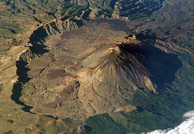
Neither IAVCEI, nor the field guide authors nor the source organisation take any
responsibility for any harm or accidents that might occur to people or property using these
field guides. Person(s) who choose to use these field guides take total responsibility for their
own safety and welfare in using the field guides.
Cities on Volcanoes 6 Conference
               Tenerife, 30th May-4th June, 2010

                            Fieldtrip #A17

       “Explosive Volcanism of Tenerife,
               Canary Islands”
                      Dates: June 5 – 7, 2010

            Leaders: Ray Cas and Adrian Pittari
(Field Guide written by: Cas, R.A.F., Pittari, A., Edgar, C., Middleton,
                   J., Marti, J. and Wolff, J.A. 2010)

SPACE SHUTTLE IMAGE, NASA

                                                                       1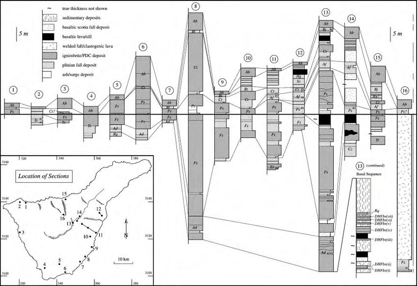
INTRODUCTION: THE VOLCANIC EVOLUTION OF TENERIFE

    Tenerife is an extremely complex volcanic system, having been at various times in its history
an oceanic basaltic shield volcano, a stratovolcano edifice and a highly explosive caldera system,
sometimes with more than one of these personas active simultaneously. Tenerife ranks as the
second largest island shield volcano on Earth after the island of Hawaii (Mauna Loa, Kilauea and
Mauna Kea). It has been constructed by numerous phases of volcanism, encompassing a diverse
range of volcanic processes and spanning more than 12 million years (Marti and Mitjavila 1995;
Marti and Wolff 2000; Table 1; Fig. 1). This history can be subdivided into four major stages:
    •    Stage I (>12 – 3.3 Ma) involved the growth of several emergent alkali basaltic shields
(Old Basaltic Series).
    •    Stage II (3.8 – 1.8 Ma) saw the construction of a central volcanic complex (Lower Group
of the Las Cañadas Edifice).
    •    Stage III (1.57 – 0.188 Ma) includes three extended cycles of highly explosive phonolitic
activity and associated caldera formation (Upper Group of the Las Cañadas Edifice) with on-going
shield-building by basaltic flank eruptions (Dorsal Rift Zone, Santiago Rift Zone, Southern
Volcanic Zone) and major debris avalanche events (Güímar, La Orotava and Icod valleys).
    •    Stage IV (0.188 – 0 Ma) witnessed the growth of a new central stratovolcano complex
(Teide-Pico Viejo Formation) within the older caldera, accompanied by continued shield-type flank
activity (Recent Basalts). Volcanic activity has continued into historical times, with the most
recent eruption occurring in 1909.

                   Figure 1. Simplified general geology of Tenerife, depicting the major stages
                   in the volcanic evolution of the island. From Pittari (2004), after Ablay and
                   Kearey (2000).

    There is considerable debate on the origin of the Las Cañadas Caldera, the large central
summit depression. One model attributes the caldera to multiple, debris avalanche mass wasting
processes and the other to major caldera collapse associated with large-scale explosive
eruptions. Independent work on the stratigraphy and geochronology have led to competing
stratigraphic schemes, and interpretations of the island’s evolution (e.g. Martí et al., 1994; cf.
Ancochea et al., 1999; Huertas et al., 2002, Bryan 1998, Edgar 2003, Middleton 2006).
    In this review the stratigraphy developed by Martí et al. (1994, 1997), Bryan (1998), Edgar
(2003) and Middleton (2006) will be employed. The estimated volumes of the pyroclastic products
of individual plinian eruptions as well as several other lines of evidence are consistent with caldera
collapse, although large-scale landslide events were also clearly important in the volcanic history
of the island (Ablay and Hürlimann 2000; see below), and at times probably linked to major
caldera forming eruptions.

                                                                                                    2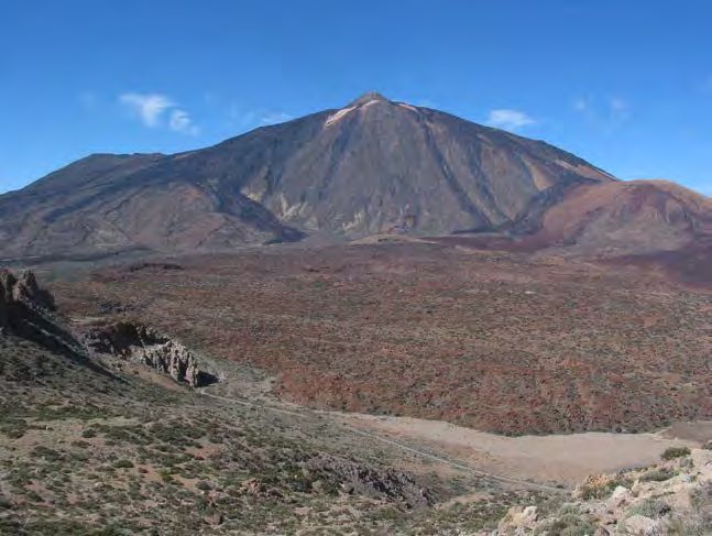
THE OLD BASALTIC SERIES (OBS)
The oldest exposed rocks on Tenerife are known collectively as the Old Basaltic Series, OBS
(Fúster et al., 1968). The OBS outcrops in several disconnected and highly dissected massifs –
Roque del Conde in the southwest, Teno in the northwest and Anaga in the northeast (Fig. 1).
These massifs comprise the products of millions of years of fissure-fed eruptions of alkali basalts,
ankaramites and basanites, including lavas, pyroclastic and epiclastic deposits and shallow
intrusive rocks (Table 1; Fúster et al., 1968). Minor felsic products occur near the tops of the
Teno and Roque del Conde successions and throughout the Anaga sequence (Ancochea et al.,
1990). A detailed account of stratigraphic data and K/Ar age determinations for these rocks is
40 39
given by Ancochea et al. (1990) and more recent Ar/ Ar dates and geochemical data have been
presented by Thirlwall et al. (2000).
The OBS represents the construction of several Hawaiian-type alkali basaltic shields, which
emerged above sea level at least 12 Ma ago and remained active until 3.3 Ma (Ancochea et al.,
1990). This old basaltic shield complex accounts for most of the volume of the island, even
though its remnants only occupy a fraction of the present surface area due to extensive cover by
more recent volcanic products (Martí et al., 1995). The original structure and morphology of the
shield complex are unclear. Basaltic shield building volcanism however continues to the present
day through activity from the flanking rift zones.
THE LAS CAÑADAS EDIFICE: LOWER GROUP (LG)
The Las Cañadas Edifice is the major central volcanic complex of Tenerife (Hausen, 1956;
Fúster et al., 1968; Araña & Brändle, 1969; Ridley, 1970a, 1970b; Araña, 1971; Ancochea et
al., 1990, 1999; Martí et al., 1994) and it was built on the remnants of the Old Basaltic Series.
Two major stratigraphic intervals have been identified by Martí et al. (1994): a Lower Group (LG)
representing a complex constructive phase and an Upper Group (UG) characterized by cycles of
highly explosive, caldera forming volcanism and partial destruction of the edifice (Table 1). Only
the upper part of the Lower Group is exposed at the surface. The best-studied outcrops occur in
the bounding scarps of the Las Cañadas Caldera (Fig. 2). The Roques de García form a spur of
LG rocks which projects out into the Las Cañadas Caldera. Lower Group lavas are also widely
exposed beneath Upper Group deposits on the outer flanks of the edifice, particularly in the west
and in the deeper barrancos of the southeast (Fig. 3).
Early radiometric dating pointed to a hiatus in volcanic activity between the end of the OBS
construction (3.3 Ma) and the beginning of the Las Cañadas activity (3.3 Ma) and this was
characterized as a period of quiescence and erosion (Ancochea et al., 1990). More recent dating
(Martí et al., 1994), however, has revealed that Lower Group activity began as far back as 3.8 Ma
with the construction of a mafic edifice known as the Boca Tauce volcano, whose presence below
the surface has been interpreted from gravity data (Ablay & Kearey, 2000). There was thus no
significant interruption in volcanic activity between Stages I and II. There was, however, a long
period of repose between the end of the Lower Group (approximately 1.8 Ma) and the beginning
of the Upper Group (1.57 Ma) of the Las Cañadas Edifice (Martí et al., 1994).
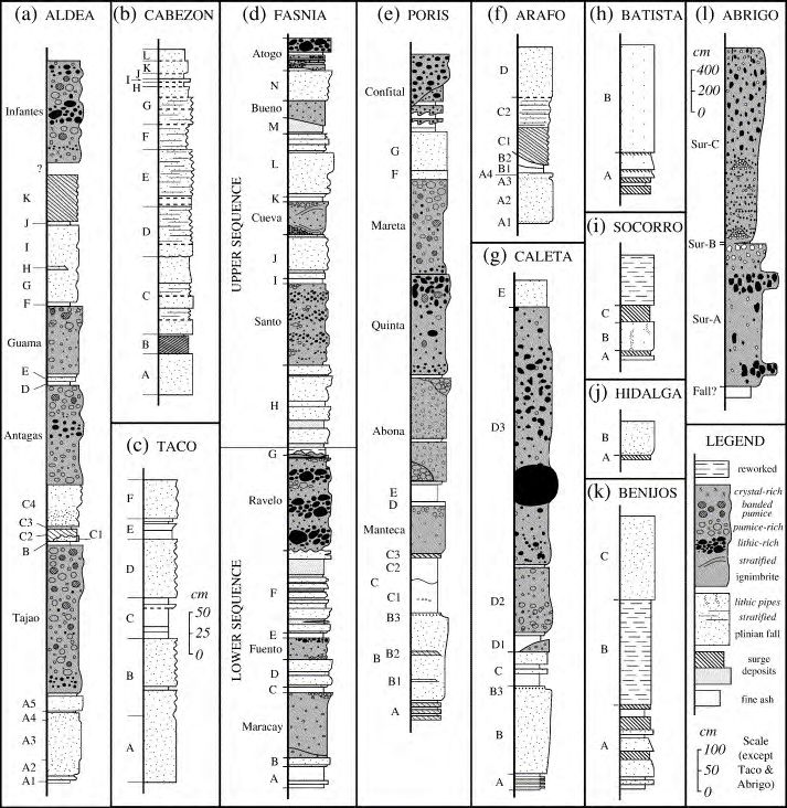
The complex stratigraphy of the Lower Group (LG) has not been studied in detail but Martí et
al. (1994) subdivided it into seven informal “sequences” on the basis of palaeosols and erosional
unconformities. As exposed in the caldera wall, these are (in clockwise order): El Cabezón, Las
Pilas, Las Angosturas, Montón de Trigo, Roques de García, Boca de Tauce and El Cedro (Fig. 2;
Table 1). The geochemistry of these sequences ranges from basaltic and trachybasaltic to
phonolitic, and deposits include lavas, welded rocks and non-welded pyroclastic deposits (Martí et
al., 1994). These authors attributed the stratigraphic complexity of the preserved succession to
the existence of a number of overlapping vents rather than a centralized system.
The Lower Group represents the transition from an early shield-building phase (represented
by the Old Basaltic Series) to post-shield volcanic activity, as observed on other islands in the
Canary group. The greater proportion of evolved trachytic and phonolitic compositions in the
eruptive products of Lower Group age signifies the development of relatively shallow magma
chambers in which crystal fractionation and crustal assimilation could occur. These eruptions
gradually constructed a composite stratovolcanic complex. Morphological reconstructions
suggest that this edifice was elongate along a NNE-SSW axis and attained an altitude of 2700-
3000 m (Araña, 1971).
3
Table 1. Stratigraphic scheme for the island of Tenerife, showing the major constructive and destructive
episodes as presented in the literature (see text for references). From Edgar (2003).

                                                                                                           4
Figure 2. (a) Schematic illustration of the stratigraphy of the Las Cañadas
                 caldera wall, showing the seven sequences of the Lower Group and three
                 formations of the Upper Group (From Edgar, 2003, after Martí et al., 1994).
                 (b) Map showing the caldera wall sectors and outlines of the three major
                 vertical collapse calderas as proposed by Martí et al. (1994): 1 - Ucanca, 2 -
                 Guajara, 3 - Diego Hernández (i.e. younging to the NE). The inferred
                 positions of the La Orotava (LO) and Icod (I) landslide scarps are also shown
                 (dashed lines); compare with the landslide model in Fig. 1.9a. PG: Pico de
                 Guajara, T: Teide, PV: Pico Viejo.

                   Figure 3. Las Cañadas Edifice, Lower Group (highly simplified). From
                   Edgar (2003). Data sources: Martí et al. (1994); Fúster et al. (1994); Bryan
                   (1998); Ablay & Hürlimann (2000, Boca Tauce Volcano).

THE LAS CAÑADAS EDIFICE: UPPER GROUP (UG)
   The Upper Group was defined by Martí et al. (1994) in their stratigraphic and geochronological
study of the Las Cañadas Caldera wall (Fig. 2). The contact between the Upper and Lower
Groups was identified as a regional erosional unconformity, representing a hiatus in central
volcanic activity of up to 0.4 Myrs. The Upper Group itself was subdivided into three major
formations – Ucanca (1.57-1.07 Ma), Guajara (0.85-0.57 Ma) and Diego Hernández (0.37-0.188
Ma) – composed of phonolitic pyroclastic deposits and subordinate basaltic rocks (Table 1; Martí

                                                                                                  5
et al., 1994, 1997). The age span of the Diego Hernández formation may however, extend
beyond 0.37 Ma. These formations were interpreted to represent three distinct cycles of explosive
phonolitic volcanism sourced from calderas and their vents within the area now occupied by the
Las Cañadas Caldera. Intervening repose periods (lasting up to 0.23 Ma each) were
characterized by widespread mafic volcanism sourced by both central and flank vents. Each
cycle produced a caldera, and each successive cycle led to the migration of the locus of volcanic
activity and caldera formation to the northeast, resulting in the progressive enlargement of the Las
Cañadas nested caldera complex (Martí et al., 1994).
In contrast to the areally restricted Lower Group sequences, the Upper Group formations are
extensively exposed along the caldera wall (Fig. 2). Furthermore, a distal succession of phonolitic
pyroclastic deposits – primarily non-welded ignimbrites and plinian fall deposits – accumulated on
the lower slopes of the island (Booth, 1973; Wolff, 1985; Alonso, 1989; Bryan, 1998; Bryan et al.,
1998a, 1998b, 2000; Brown et al., 2003; Brown and Branney 2004; Edgar 2003; Edgar et al.
2002; Pittari 2004; Pittari and Cas, 2004; Pittari et al., 2005, 2006). Due to the stratigraphic
complexity of the pyroclastic succession, the proximal-distal facies variations and the sparsity of
medial exposure, only a few units have been correlated between distal and proximal areas (Martí
et al., 1994; Bryan et al., 1998a). Quaternary distal ash deposits found in Ocean Drilling Project
(ODP) drill holes up to 156 km east and southeast of Tenerife have been correlated with the
Upper Group by geochronological (Van den Bogaard, 1998) and geochemical (Rodehurst et al.,
1998) criteria. Although detailed (member-level) correlations have not yet been made, these
studies may provide important constraints on the dispersal of tephra fallout and subaqueous
pyroclastic density currents. Van den Bogaard (1998) found that plinian activity from the Las
Cañadas Edifice during the Upper Group period was more or less continuous and suggested that
the recognition of distinct formations by Martí et al. (1994) was an artefact of an incomplete
onshore tephra record. Sumita et al. (2000) reported that 10-20% of the Pleistocene
volcaniclastic layers (up to 450 total) in these drill holes could be interpreted as products of flank
collapses and major plinian eruptions.
Ucanca Formation (UF)
The oldest subdivision of the Upper Group, the Ucanca Formation (UF) has a known age
range of 1.57 to 1.07 Ma (Martí et al., 1997). It extends along the southern and southeastern
sectors of the caldera wall and is thickest in the southwestern sector (Figs 2, 4). It comprises a
sequence of peralkaline phonolitic lavas, welded and non-welded fall units, welded and non-
welded ignimbrites, intraformational lithic breccias, pyroclastic surges and clastogenic lavas
(Soriano et al. 2002), with minor interbedded lavas and pyroclastics of basaltic composition.
These deposits were produced by a succession of highly explosive plinian eruptions sourced from
vents within the present-day caldera depression and often close to the caldera wall (Martí et al.,
1994).
Distal deposits: Welded and non-welded ignimbrites and plinian fall deposits of Ucanca age
have been found on the southwestern, southeastern and northern flanks of the island (Fig. 4;
Martí et al., 1994; Fúster et al., 1994; Huertas et al., 2002; Edgar 2003). Due to surface erosion
and burial by younger deposits, the distal Ucanca Formation is poorly exposed except in the
southwest (Fúster et al., 1994). The most detailed stratigraphy for these deposits has been
proposed by Huertas et al. (2002) but this work does not recognize the stratigraphic subdivisions
(such as the Ucanca and Guajara formations) developed by Martí et al.(1994).
6Figure 4. Ucanca Formation and the Caldera del Rey phonolitic maar
complex. From Edgar (2003). Data sources: Fúster et al. (1994); Ibarrola et
al. (1993); Huertas et al. (2002).
Guajara Formation (GF)
Extending along the southeastern sector of the caldera wall and unconformably overlying the
Ucanca Formation is the Guajara Formation (GF), with age data spread between 0.85 and 0.57
Ma (Martí et al., 1994; Bryan et al., 1998a; Bryan, 1998). With a maximum thickness of 250 m at
Pico de Guajara, the Guajara sequence represents a second cycle of highly explosive and largely
phonolitic eruptions. It produced a similar range of deposits as the preceding Ucanca cycle.
Preservation and outcrop of the stratigraphy of the Guajara Formation is however better than for
the Ucanca Formation. Booth (1973) and Booth and Walker (unpublished data) were the first to
attempt a stratigraphic subdivision of the Guajara Formation, followed by Alonso (1989). More
recently Bryan (Bryan et al., 1998a; Bryan, 1998) and Middleton (2006) have considerably
advanced understanding of the stratigraphy and volcanology of the Guajara Formation. Proximal
deposits include both non-welded and welded deposits (Middleton 2006; Soriano et al. 2009).
Distal deposits: The Guajara Formation is also distributed widely on the middle and lower
southeastern slopes (Fig. 5; Martí et al., 1994; Bryan et al., 1998a; Edgar 2003; Middleton 2006),
on the Tigaiga massif (Ibarrola et al., 1993) and offshore (Van den Bogaard, 1998), consistent
with the magnitude and style of the eruptions. Although likely Guajara Formation correlates have
been mapped in the north and northwest (in this study), by far the most extensive and highest
quality exposure of this pyroclastic succession occurs in the south and southeast of the island,
where it underlies the Diego Hernández Formation. Deposits away from the caldera are generally
non-welded, although the Arico ignimbite is the only welded ignimbrite away from the caldera wall
succession, and it is widely welded (Schmincke and Swanson 1967; Middleton 2006). The
Guajara Formation in the Bandas del Sur consists of large volume pyroclastic fallout, flow
(ignimbrite) and minor surge deposits. All deposits are non-welded except for parts of the Arico
Ignimbrite. The stratigraphic record contains fewer units than the overlying Diego Hernandez
Formation, and it is unclear if this truly reflects fewer explosive events, or whether, due its older
age, erosion has stripped away more the stratigraphy. The principal units and eruptive events are
represented by the 569/600 ka Granadilla Pumice (Bryan et al. 2000), which represents one of the
largest volume pyroclastic eruptive packages mapped on Tenerife, including fallout and ignimbrite
3
units that each exeed 5 km in volume (Bryan e al. 2000), the 596 ka Abades Member, the
Incendio Member, the 610/668 ka Arico Member, the Helecho Member, and a series of less well
known, older fall dominated units (Eras, Rio, Zarza, Blanquitos, Menas and Vegas) (Middleton
2006).
A major problem with understanding the Guajara Formation remains the difficulty of correlation
of Guajara Formation age rocks preserved in the caldera wall with deposits on the flanks of
Tenerife, especially on the Bandas del Sur, on the arid south side of Tenerife, where the exposure
of the Guajara Formation stratigraphic units is good, but discontinuous. Thick sequences of both
non-welded and welded rocks in the caldera wall in the section up to Pico de Guajara have not
7been uniquely correlated to specific units on the Bandas del Sur using geochemistry, facies or
geochronology.
Figure 5. Distribution of the Guajara Formation, showing the
contemporaneous Montaña Guaza phonolitic lava dome complex and the
Güímar and Orotava landslides. From Edgar (2003) with extra data from
* (Bryan, 1998) and Tigaiga massif (Ibarrola et al.,1993).
Diego Hernández Formation (DHF)
The third and youngest cycle of Upper Group phonolitic volcanism produced the Diego
Hernández Formation, DHF (Araña, 1971; Mitjavila, 1990; Mitjavila & Villa, 1993; Martí et al.,
1989, 1990, 1994; Edgar 2003; Pittari 2004). The DHF is defined to include the products of all
central phonolitic volcanism on Tenerife between 0.57 Ma (i.e. the end of the Guajara cycle) and
0.188 Ma. The mapped extent of the DHF is shown in Figure 6. Unlike the two older formations,
the proximal DHF is restricted to the eastern sector of the caldera wall, where it infills a broad
depression, the DH palaeovalley (Fig. 2). In terms of proximal facies, the DHF succession is
distinguished from the two older formations by the scarcity of welded rocks; it is dominated by
non-welded ignimbrites and minor plinian fall deposits (Martí et al., 1990, 1994; Edgar (2003).
The succession is capped by a coarse lithic lag breccia, rich in syenite fragments, which has been
correlated with a widespread lithic-rich ignimbrite exposed on the lower slopes, the Abrigo
ignimbrite (Alonso, 1989; Martí et al., 1994; Pittari 2004; Pittari and Cas, 2004; Pittari et al., 2005,
3
2006). This deposit, which is at least 5km in volume, is thought to record a climactic caldera-
forming eruption at 0.188 Ma (Nichols, 2001; Nichols et al., 2001), completing the incremental
growth of the Las Cañadas Caldera and bringing the Diego Hernández cycle to an end. With the
exception of the Abrigo ignimbrite, the proximal and distal deposits of the DHF have until recently
remained poorly correlated due to the lack of medial exposure, the complexity of the stratigraphy
and unpredictable lateral facies variations (e.g. Bryan et al., 1998a). Detailed mapping, section
logging and deposit characterisation by Edgar (2003) have led to detailed correlations becoming
possible between the caldera wall succession and the Bandas del Sur DHF succession. On the
Bandas del Sur, mapping by Edgar (2003) and detailed volcanological studies by Edgar (2003),
Edgar et al. (2002, 2007), Brown et al. (2003), Brown and Branney (2004), Pittari (2004), Pittari
and Cas (2004) and Pittari et al. (2005, 2006) have led to significantly improved understanding of
the volcanic eruptions styles, dispersal processes and deposit characteristics of Tenerife.
Distal deposits: The Diego Hernandez Formation is also best preserved on the Bandas del
Sur, where it consists of widespread, well-preserved successions of non-welded pyroclastic
fallout, flow (ignimbrite) and co-ignimbrite surge deposits. Although some eruptions were relatively
simple, with initial plinian fallout deposits followed by one or more ignimbrite units, others were
extremely complex (e.g. Fasnia Member, Poris Member; e.g. Edgar et al. 2002; 2007; Brown et al.
2003, Brown and Branney 2004), with numerous intra-plinian ignimbrites interrupting thick plinian
fallout deposits. The Fasnia Member contains seven such intra-plinian ignimbrites and has a
3
volume well in excess of 13km DRE (Edgar 2004).
8Figure 6. Distribution of the Diego Hernández Formation (From Edgar
2003).
THE TEIDE-PICO VIEJO FORMATION (TPVF)
The Teide-Pico Viejo Formation (TPVF) consists of the twin stratocones of Teide and Pico
Viejo, numerous satellite vents and outflow lavas (Hausen, 1956; Araña, 1971; Ablay, 1997; Ablay
et al., 1998; Ablay & Martí, 2000; Marti & Geyer 2009). Teide began to form at least 150 kyrs ago,
initially dominated by basaltic activity and becoming progressively tephri-phonolitic to phonolitic,
especially from about 20 ka on. With an altitude of 3718 m, the summit of Teide forms the highest
point on the island and, indeed, in all of Spain. The TPVF postdates the Upper Group and the
formation of the Las Cañadas Caldera (0.20 Ma), which it partially infills. It comprises a thick
sequence of basanite lavas overlain by more evolved lava sequences, ranging from phonotephrite
to phonolite (Table 1; Ablay & Martí, 2000). Drilling in the floor of the Las Cañadas Caldera has
revealed TPVF lava sequences exceeding 500 m in thickness and the pre-TPV caldera floor has
not been intersected (Martí et al., 1994; Ablay & Martí, 2000). Many TPVF lavas also flowed north
and west down the flanks of the Las Cañadas Edifice (Fig. 7). TPV activity is thought to have
been sourced by two distinct phonolitic magma chambers with different depths and physical
conditions, with activity alternating between Teide and Pico Viejo in the recent history of the
complex (Ablay & Martí, 2000). Eruptions have occurred from both summit and flank vents,
determined by the stress fields generated by each new magma batch and chamber (Martí &
Geyer 2009; del Potro et al. 2009). The black lavas on the slope of Teide are thought to have
been erupted about 1,150 yrs B.P. An historic eruption occurred at Pico Viejo in 1798 (Table 1).
The largest explosive phonolitic eruption on Tenerife since the end of the DHF cycle occurred at
Montaña Blanca (Fig. 8), a major satellite system of the TPV system, approximately 2000 years
3
ago (Ablay et al., 1995). This sub-plinian eruption dispersed 0.08 km of tephra (Ablay & Martí,
2000) over the eastern sector of the caldera and the proximal Dorsal Ridge. However, no TPVF
eruptions have produced fall deposits of plinian dispersal and the youngest phonolitic pyroclastic
deposits exposed on the lower flanks of the island belong to the DHF. Petrological studies show
that the tephri-phonolite magma eruption from Pico Viejo in 1798 was stored at a depth of 5+1
kms prior to eruption (Andújar et al. 2010).
THE DORSAL AND SANTIAGO RIFT ZONES
The Dorsal Ridge (or Dorsal rift) is a major basaltic fissure-vent system extending along a NE-
SW lineament from the eastern sector of the Las Cañadas Edifice towards the Anaga Massif (Fig.
8). Morphologically, it forms a high-relief crest or spine which becomes higher (2400 m, Montaña
de Abreo) and broader to the southwest (here referred to as the “proximal” Dorsal Ridge).
Despite its inclusion in several general studies on the geology and geochronology of Tenerife (e.g.
Fúster et al., 1968; Ancochea et al., 1990), it remains poorly understood. The products of this
system, known collectively as the Dorsal Series, include scoria cone complexes and thick lava
sequences. The age data of Ancochea et al. (1990) were interpreted to indicate a period of rapid
9growth between 0.9 and 0.78 Ma, although activity on the Dorsal Ridge stretches back to at least
1.8 Ma (Feraud et al. 1985) and has continued to the present day. Historic activity includes the
1492 Cangrejo eruption, 1704-5 basaltic eruptions of the Arafo, Volcán de Fasnia, and Siete
Fuente scoria cones, which occurred along an 11 km-long fissure trending SW just south of the
Dorsal Ridge, 1706 Garachico lava eruption, and Tenerife’s most recent eruption, the 1909
Chinyero lava eruption (Dóniz et al. 2008; Martí et al. 2008). The inter-bedding of phonolitic
pyroclastic deposits of the Diego Hernández Formation within the complex basaltic stratigraphy of
the proximal Dorsal Ridge (described in this study) indicates the contemporaneous activity of the
two adjacent magma systems (Table 1). Alternative names for the Dorsal Ridge include the
Cordillera Dorsal (Fúster et al., 1968; Ancochea et al., 1990) and the Cumbre de Pedro Gil
(Ridley, 1970a, 1971; Feraud et al., 1985).
Figure 7. Teide-Pico Viejo Formation (From Edgar 2003, adapted from
Ablay & Martí, 2000).
The smaller Santiago Rift Zone (Ablay & Martí, 2000) forms a NW-trending zone of intense
mafic to intermediate volcanism extending between Pico Viejo and the Teno Massif (Fig. 8). Like
the Dorsal rift, it is a fissure-vent system formed by a large number of monogenetic cones and
lava flows. Its age is poorly constrained (>0.3 Ma, Ablay & Martí, 2000) but it remains active to
the present day. Historic activity includes the 1492 Cangrejo eruption, 1706 Garachico lava
eruption, and Tenerife’s most recent eruption, the 1909 Chinyero lava eruption (Dóniz et al. 2008;
Martí et al. 2008). The Dorsal and Santiago rift zones have been interpreted as two arms of a
three-branched rift system, a model which was used to support a hotspot origin for the Canary
Islands (Carracedo, 1994). The third branch was identified as the broad zone of flank volcanism
extending southward into the Bandas del Sur (see below) – here referred to as the Southern
volcanic zone (after Ablay & Martí, 2000). However, this model was questioned by Martí et al.
(1996) who suggested the Dorsal and Santiago rifts are part of a continuous axis of extension and
volcanism which also underlies the active TPV stratovolcanic complex (Ablay & Martí, 2000).
Geyer and Marti (2010) propose the Dorsal and Santiago rift zones reflect contemporary
volcanism that originated from crustal fractures that acted as fissure vents from the beginning on
shield forming volcanism that has built Tenerife as an oceanic shield volcanic system.
FLANK VENTS
Flank Basalts
A large number of small basaltic volcanoes, mainly monogenetic strombolian cones, dot the
flanks of the Las Cañadas Edifice (Fig. 8; Carracedo et al. 2007; Kröchert and Buchner 2009).
These have been classified in various ways by different researchers. The nomenclature used
here derives from Fúster et al. (1968), who identified three “series”: Trachytic and Trachybasaltic
Series, Basaltic Series III and Recent Basic Series (their Recent Acidic Series corresponds to the
Teide-Pico Viejo Formation). The Trachytic and Trachybasaltic Series includes the Montaña de
Guaza and Caldera del Rey (discussed separately below) as well as a number of lava flows of
variable composition scattered around the island.
10Figure 8. Distribution of flank basalts and Icod landslide. DRZ = Dorsal
Ridge Rift Zone; SRZ = Santiago Rift Zone; SVZ = Southern Volcanic
Zone. From Edgar (2003). Data sources: Fúster et al. (1968); García
Moral (1989); Bryan (1998).
The more extensive Basaltic Series III was originally defined as postdating the Las Cañadas
Edifice and predating the TPV Formation. However, they are now considered to predate or be
contemporaneous with the DHF cycle of the Upper Group of the Las Cañadas Edifice (Table 1;
Cycle 3 basalts of Bryan et al., 1998a). Series III basaltic scoria deposits and lava flows were
erupted from a large number of strombolian vents, many of which were aligned along structural
lineaments. They are concentrated in the south, northwest and northeast of the island and have
been interpreted as a major basaltic phase separating different cycles of central phonolitic
volcanism (Martí et al., 1994, 1997; Bryan et al., 1998a). Studies of individual cones include that
of the Montaña de Taco in the Isla Baja region by Alonso et al. (1992). Finally, the Recent Basic
Series or Basaltic Series IV refers to the products of a number of widespread basaltic eruptions
which occurred in prehistoric or historic times (Fúster et al., 1968; García Moral, 1989). Major
volcanic fields arose in the Valle de San Lorenzo in the south, part of the Southern volcanic zone
and on the Santiago ridge in the northwest. Krochert and Buchner (2009) have demonstrated that
basaltic volcanism in the southern Bandas del Sur region occurred cyclically from 948- 779, 323-
300 and < 95 ka, whereas Clarke et al. (2009) have documented both magmatic and
phreatomagmatic explosive styles from monogenetic volcanoes in the Bandas del Sur.
Geophysical surveys have also revealed ongoing submarine volcanism on the seafloor
surrounding Tenerife (e.g. Ablay & Hürlimann, 2000; Krastel & Schmincke, 2002).
Montaña Guaza
Montaña Guaza (Buch, 1825; Fritsch & Reiss, 1868; Hausen, 1956; Fernández Santín &
Nafría López, 1978; Fúster et al., 1994) is a steep-sided, trachytic-phonolitic lava dome complex
situated in the western Bandas del Sur adjacent to the coastline (Fig. 5). Ancochea et al. (1990)
obtained a K/Ar age of 0.67 Ma for one of the trachytic lava flows, indicating contemporaneity with
the Guajara Formation of the Las Cañadas Edifice.
Caldera del Rey
Located 4 km NW of Montaña Guaza in the shadow of the Roque del Conde OBS massif is the
Caldera del Rey (Fig. 4), a double-cratered phonolitic maar. The products of this eruption centre
consist mainly of successions of pyroclastic surge and fall deposits (some rich in accretionary
lapilli), characteristic of a phreatomagmatic eruption style (Paradas Herrero & Fernández Santín,
1984). They extend to a radius of approximately 4 km (Fúster et al., 1994), although Bryan et al.
(1998a) attributed widespread ignimbrite and plinian fall deposits of the Diego Hernández
Formation to this centre (the Caldera del Rey Pumice and Ignimbrite Members dispersed up to 20
km to the east). Paradas Herrero & Fernández Santín (1984) suggested that activity of the
Caldera del Rey was contemporaneous with Basaltic Series III (i.e. post-Guajara Formation, pre-
11to syn-DHF) based on the stratigraphic relationships of plinian fall deposits which they believed
were produced by the maar. This scheme was followed by Bryan et al. (1998a). However, Fúster
et al. (1994) obtained a K/Ar date of 1.54 ± 0.28 Ma and Huertas et al. (2002) presented a more
40 39
precise Ar/ Ar date of 1.13 ± 0.03 Ma. This is far older than Series III and is consistent with
stratigraphic data which indicate contemporaneity with the Ucanca Formation (Table 1.1). These
relationships place important constraints on the interpretation of the DHF stratigraphy.
M AJOR LANDSLIDES AND CALDERA FORMATION: ARE THEY RELATED?
Types of degradational processes
In addition to the usual sedimentary processes which slowly contribute to the erosion of
landscapes, Tenerife retains evidence of having been subject to numerous gravitational collapse
events which generated various mass flow phenomena. Furthermore, a long history of highly
explosive and relatively large-volume pyroclastic eruptions must have resulted in some form of
caldera collapse. Several large depressions bounded by scarps have generated long-running
controversy among scientists as to their origin and evolution. The most notable of these are the
Güímar, La Orotava and Icod valleys, and the central Las Cañadas Caldera.
Güímar and La Orotava valleys
The Güímar and La Orotava valleys are 6-10 km-wide depressions open to the sea, situated
on either side of the Dorsal Ridge in central Tenerife (Fig. 5). They are bounded by steep, linear
scarps up to 600 m high and have relatively flat, gently sloping floors. Their genesis has been
variously attributed to horst-and-graben style extensional faulting (Hausen, 1956), “trap-door”
caldera collapse due to magma withdrawal (Ridley, 1971), progressive lateral expansion via
erosional processes (Palacios, 1994), and giant landslides or debris avalanches (Bravo, 1962;
Coello, 1973; Ancochea et al., 1990; Carracedo, 1994, 1999; Martí et al., 1997; Cantagrel et al.,
1999; Ablay & Hürlimann, 2000; Masson et al., 2002). There is now a general consensus that
large-scale landslide processes were instrumental in the formation of these major morphological
features. Sonar surveys of the sea floor off the north coast of Tenerife have revealed debris
3
avalanche deposits extending 100 km offshore with a total estimated volume of 1000 km (Watts
& Masson, 1995, 2001).
The head region of the La Orotava valley is thought to be exposed in the eastern sector of the
Las Cañadas caldera wall (Fig. 5; Bravo Bethencourt & Bravo, 1989; Ancochea et al., 1990; Martí
et al., 1997; Cantagrel et al., 1999). The steep head scarp truncates the Las Pilas sector and the
topographic depression produced (the DH palaeovalley) was subsequently infilled by successive
eruptions of the Diego Hernández Formation and the proximal Dorsal Ridge. Radiometric dating
of the youngest lava flows truncated by the valley walls (at the top of Las Pilas and the Tigaiga
Massif) and the oldest infill deposits (in the DH palaeovalley) have constrained the age of valley
formation to between 0.69 and 0.54 Ma (Ancochea et al., 1990; Cantagrel et al., 1999). Since the
climactic eruption of the Granadilla Member at the end of the Guajara Formation (0.57 Ma, Bryan
et al., 1998a) did not leave pyroclastic deposits in the DH sector of the caldera wall or elsewhere
in the La Orotava infill, valley formation is further constrained to the period 0.57-0.54 Ma (Table 1).
This supports the recent proposal of a genetic link between climactic caldera collapse at the end
of major cycles of explosive phonolitic volcanism and major landslide events (Martí et al., 1996,
3
1997). The volume of the submarine La Orotava landslide deposit has been estimated as 80 km
by Ablay & Hürlimann (2000), who proposed two closely spaced lateral collapse events to account
for the seaward narrowing of the valley.
The Güímar valley is younger than 0.83 Ma (Ancochea et al., 1990) but is older than the La
Orotava valley, since its infill includes Guajara Formation deposits (Martí et al., 1997). The timing
of this event corresponds to a period of rapid growth of the Dorsal Ridge (between 0.9 and 0.78
Ma, Ancochea et al., 1990), which may have oversteepened the slopes and promoted
gravitational instability. The submarine debris avalanche deposit associated with the Güímar
valley has been mapped in sonar surveys in the channel which separates Tenerife and Gran
Canaria (Teide Group, 1997; Krastel et al., 2001, Krastel & Schmincke, 2002). It has also been
identified in Ocean Drilling Program (ODP) drill holes with a thickness of 4 m measured 156 km off
3
the coast (Sumita et al., 2000) and has an estimated minimum volume of ~120 km (Krastel et al.,
2001).
Icod valley
The Icod valley is another scarp-bounded depression open to the sea and thought to have
been formed by landslide processes (Ancochea et al., 1990; Martí et al., 1997; Carracedo, 1999;
Cantagrel et al., 1999; Watts & Masson, 2001). It is located on the northern slopes, separated
from the La Orotava valley by the Tigaiga Massif, a high-relief remnant of the Las Cañadas Edifice
(Fig. 8). The Icod valley has been significantly infilled by lavas of the TPV Formation and the
12position of its headwall is uncertain. No Upper Group deposits have been found within it, and its
formation therefore postdates the DHF. Martí et al. (1997) proposed that climactic caldera
collapse associated with eruption of the Abrigo Member at the end of the Diego Hernández
Formation (0.20 Ma) triggered the Icod landslide event. On the basis of sonar surveys of the
submarine Icod landslide deposit, Watts & Masson (2001) identified two flow lobes, Icod I and
Icod II, thought to have been generated by a single, complex lateral collapse event. Ablay &
3
Hürlimann (2000) inferred a deposit volume of 80 km based on a separate geophysical survey of
the seafloor.
Other landslide events
Recent studies have also presented evidence that landslides also occurred during the growth
of the Old Basaltic shield complex, affecting the north flanks of the Anaga and Teno massifs at ~6
and 5.6 Ma respectively (Cantagrel et al., 1999; Ablay & Hürlimann, 2000; Masson et al., 2002;
Walter & Schmincke, 2002). Another generation of “old post-shield landslides” was identified by
Ablay & Hürlimann (2000) and interpreted as products of major north-directed failure of the LCE
and proto-Dorsal Ridge at ~3 Ma to form a large amphitheatre, now buried. These authors also
identified a distinct landslide event affecting the northeastern flank of the Dorsal Ridge. The age
of this East Dorsal landslide is poorly constrained (140 km (Martí et al., 1994). The spur of the Roques
de García is conventionally used to divide the caldera into eastern and western parts (Hausen,
1956; Martí et al., 1994).
The origin of the LCC has been the most contentious issue in the geological investigation of
Tenerife. Early ideas expressed by Buch (1825) envisioned upheaval followed by collapse of the
summit (his “crater of elevation” concept). Charles Lyell visited the island in 1853-54 and
proposed an erosional origin by the action of running water (Lyell, 1855). Fritsch & Reiss (1868)
proposed a combination of erosion and great explosions. Gagel (1910) likened the explosive
origin of the caldera to the 1883 eruption of Krakatoa (Indonesia), while Friedländer (1915) and
Fernández Navarro (1916) suggested collapse similar to that of Somma Vesuvius. In the second
half of the twentieth century, two competing models developed and are yet to be reconciled, one
emphasizing landslide processes (Bravo, 1962; MacFarlane & Ridley, 1968; Navarro & Coello,
1989; Ancochea et al., 1990, 1999; Carracedo, 1994, 1999; Cantagrel et al., 1999) and the other
emphasizing caldera collapse (Hausen, 1956, 1961; Fúster et al., 1968; Araña, 1971; Ridley,
1971; Booth, 1973; Martí et al., 1994, 1996, 1997; Bryan et al., 1998a, 2000; Martí &
Gudmundsson, 2000). These two models are summarized briefly here.
The landslide model proposes a similar genesis for the LCC as is generally accepted for the
Güímar, La Orotava and Icod valleys: one or more large-scale seaward lateral collapse events
generating debris avalanches and remnant scarp-bounded depressions. The main arguments put
forward to support this model are as follows:
• Numerous tunnels (Spanish: galerías) have been excavated into the flanks of the island
for the purpose of extracting drinking water from aquifers. Investigations of the subsurface
geology exposed in the galerías on the northern slopes (Bravo, 1962; Coello, 1973; Navarro &
Coello, 1989; Coello & Bravo, 1989) encountered a widespread chaotic breccia up to 300 m thick,
13dipping gently towards the coast. This “fanglomerado” deposit (Bravo, 1962) consists of
subangular to rounded clasts of variably altered basalt, trachyte, phonolite and minor gabbro and
carbonized wood fragments in a finer matrix. It was originally interpreted as the widely dispersed,
explosive product of an early destructive phase of the Las Cañadas Edifice, which was buried by
lavas and subsequently acted as a detachment for large-scale landslide events (Bravo, 1962;
Coello, 1973; Carracedo, 1994). Later workers reinterpreted the “fanglomerado” facies as the
deposits of major debris avalanches (Navarro & Coello, 1989; Ancochea et al., 1999; Cantagrel et
al., 1999).
• The absence of a caldera wall in the northwest is assumed to support the idea that there
never was an enclosed summit depression, as would be expected to result from caldera collapse
into a magma chamber. Rather, the existing “caldera” wall is the head wall for one or more major
north-directed flank failures (Coello, 1973; Ancochea et al., 1999; Cantagrel et al., 1999).
Remnants of a northern caldera wall have not been encountered in the galerías of the upper Icod
valley (Coello, 1973) and therefore they have not simply been buried by the subsequent eruptions
of the TPVF. Furthermore, the scalloped horseshoe shape of the existing caldera wall has been
claimed to bear a striking resemblance to the La Orotava and Güímar valleys (Carracedo, 1994)
and to the head scars of major landslides (Cantagrel et al., 1999; Watts & Masson, 2001).
• Finally, sonar surveys of the sea floor north of Tenerife (Watts & Masson, 1995, 2001)
have yielded evidence for multiple north-directed landslide events related to the formation of the
La Orotava and Icod valleys. Many authors have equated the Las Cañadas caldera wall with the
head scarp of the Icod landslide event, thus denying the significance of vertical caldera collapse in
forming the summit depression. They argue that the estimated volume of submarine landslide
3
deposits (1000 km ) cannot be accounted for by the La Orotava and Icod valleys alone and thus a
greater portion of the Las Cañadas Edifice must have been involved (Cantagrel et al., 1999).
The caldera collapse model identifies the primary agent in the origin of the LCC as vertical
collapse of the roof of a magma chamber following the evacuation of magma during large-scale
explosive eruptions. The growth of the caldera is assumed to have been incremental, progressing
from southwest to northeast through time (Martí et al., 1994). Proponents of this model cite
several lines of supporting evidence:
• The most obvious evidence for caldera collapse is the thick Upper Group pyroclastic
succession, representing over one million years of cyclical explosive phonolitic volcanism. Upper
Group deposits display dispersal patterns and facies characteristics indicating repeated large
plinian eruptions from source vents located within the Las Cañadas Caldera (Booth, 1973; Alonso,
1989; Martí et al., 1994; Bryan et al., 1998a, 2000). The total volume of Upper Group pyroclastic
3
material has been estimated to exceed 130 km (DRE) by Martí et al. (1994), who noted that this
3
compares well with the inferred volume of the original (pre-TPVF) depression (>140 km ). Upper
Group deposits exposed in the caldera wall, including thick welded fall deposits, clastogenic lavas
and co-ignimbrite lag breccias, are typical of proximal facies of caldera-forming eruptions (e.g.
Druitt & Sparks, 1982; Walker, 1985; Cas and Wright, 1987). The abundance of ignimbrites,
many of which are lithic-rich, in the Upper Group stratigraphy is also favorable to a caldera
collapse hypothesis (Araña, 1971).
• The morphology of the surviving caldera wall is similar to that of other collapse calderas,
its scalloped form being attributed to the overlap of multiple circular vertical collapse structures
(Martí et al., 1994). The isolated northern sector of La Fortaleza, with its south-facing
escarpment, is difficult to reconcile with north-directed sector collapse (Bryan, 1998a).
• Various structures observed in the caldera wall, including radial phonolitic dykes, cone
sheets, sills, reverse radial faults and concentric normal faults (Fúster et al., 1968; Araña, 1971;
Martí et al., 1994; Martí & Gudmundsson, 2000), support repeated episodes of magma chamber
deflation and caldera collapse. Experimental modelling of this process explains the migration of
the magma chamber following climactic caldera collapse episodes of each cyle by changes in the
local stress field (Martí & Gudmundsson, 2000).
• Detailed volcanological studies of the Granadilla Member (0.57 Ma), the youngest
eruptive unit in the Guajara Formation, have demonstrated a significant eruptive volume (>10.2
3
km according to Bryan et al., 2000) and lithic breccia facies consistent with caldera collapse
(Booth, 1973; Bryan et al., 1998a, 2000).
• Proponents of the caldera collapse model have never denied the importance of landslide
processes in modifying the northern flanks of the Las Cañadas Edifice. Indeed, a post-caldera
landslide event (associated with formation of the Icod valley) is necessary to account for the
absence of the inferred northwestern caldera wall (Booth, 1973; Martí et al., 1994, 1997).
Furthermore, Martí et al. (1997) suggested that major vertical collapse events may have triggered
the landslides which formed the La Orotava and Icod valleys. The available age data indicate that
the formation of these valleys coincides with the final eruptions of the Guajara and Diego
14Hernández phonolitic cycles respectively. Thus, the various lines of evidence used to support
northward lateral collapse events (the “fanglomerado” deposit, the sonar evidence of offshore
debris avalanche deposits, the recognized instability of oceanic island volcanoes, etc.) are not
inconsistent with the caldera collapse model.
In summary, the key point is whether the present wall of the Las Cañadas Caldera is the head
scarp produced by north-directed landslides or the surviving portion of an originally enclosed
depression formed by multiple caldera collapse events. In the latter case, the missing
northwestern wall was removed by a post-caldera northward landslide (Icod), perhaps triggered
by the final phase of caldera collapse (Martí et al., 1997). Alternatively, the Icod landslide event
may have triggered the climactic caldera-forming eruption by decompression of the magma
chamber (e.g. Ancochea et al., 1999; Scarth & Tanguy, 2001; Huertas et al., 2002). Major
episodes of sea-level fall also coincide with post-shield landslide events, suggesting another
possible trigger for lateral collapse (Ablay & Hürlimann, 2000). Other points of contention relate to
the timing of constructive and destructive events in the history of the Las Cañadas Edifice and to
the most appropriate volcanostratigraphic framework.
In the past decade, the two competing models have been updated and elaborated. To a
certain extent, there is growing recognition that the complex history of the Las Cañadas Edifice
and its summit caldera is the result of a variety of processes which include constructional phases,
caldera collapse events, landslide events and ongoing surface erosion. For example, the most
recent versions of the landslide model (Ancochea et al., 1999; Cantagrel et al., 1999; Huertas et
al., 2002) now recognize multiple caldera collapse events associated with the eruption of large
volumes of pyroclastic material. However, they claim that these vertical collapse episodes were
relatively small and left no surviving structures. The caldera wall is still interpreted as the head
scarp of at least three landslide events – Tigaiga (>2.3 Ma), Roques de García (0.6-0.7 Ma) and
Icod (Table 2. Comparison of the stratigraphic schemes that have evolved for the Upper Group. In this field guide we adopt
the scheme in the right hand column, based on the most recent stratigraphic studies of Edgar (2003) and Middleton
(2006).
VOLCANOLOGY OF THE UPPER GROUP
The occurrence of dual magma systems (basalt, phonolite) has produced a complex array of
eruption activity and styles, from basaltic fire fountaining, lava effusion and explosive
Strombolian style activity to phonolitic fire fountaining, lava effusion and highly explosive plinian
scale explosive eruptions. Phreatomagmatic activity fuelled by both surface water (crater lakes?)
and hydrothermal systems have been common. Explosive eruptions have therefore been
variously triggered by magmatic exsolution and vesiculation, phreatomagmatic explosive
interaction and hydrothermal explosions. Injection of basalt magmas into phonolite-syenite
magma chambers have also been significant eruption triggers.
Dispersal processes have included widespread plinian scale fallout, pyroclastic flow and
pyroclastic surge (e.g. Bryan 1998, Edgar 2003, 2004, Edgar et al., 2002, 2007; Middleton 2006;
Pittari 2004, Pittari & Cas 2004, Pittari et al. 2005, 2006). Many large fallout deposits have been
mostly dispersed off-shore, making eruption volume calculations more difficult. Nonetheless,
16some of the biggest fallout events have preserved thicknesses of over 50 metres near vent, and
almost 10 metres, even at 15 kms from vent (e.g. Granadilla Member fall deposit, Bryan et al.
2000; Fasnia Member fallout deposits, Edgar 2003; 2007). Many near vent fallout deposits are
welded, suggesting low fountain style eruptions (e.g. Soriano et al. 2002). Some of these welded
fall deposits became rheomorphic. Many near vent fall deposits, especially the welded ones, may
have no distal equivalent, and conversely, many of the distal fall units, even very thick ones, may
have no preserved near vent deposits because of the effects of erosion on unwelded fall deposits
on the steep upper slopes. Although many pyroclastic fall deposits are known on the vegetated
north side of the island, it appears that perhaps the majority were dispersed to the south by strong
prevailing northerly winds. Attempts to calculate the volumes of fallout deposits using the Pyle
(1989), Fierstein and Nathenson (1992), Carey et al. (1995), Bonadonna et al. (1998) and
Bonadonna and Houghton (2005) methods, have produced volume estimates of > 5 km3 for some
fallout deposits (e.g. Granadilla Member fallout, Bryan et al. 2000; Fasnia Member fallout
deposits, Edgar 2003, 2007), indicating extremely intense and large volume eruptions. Estimates
of plinian column heights are up to 25 kms for the Granadilla Pumice fall deposit (Bryan 1998) and
up to 30 kms for the Fasnia Member fallout deposits (Edgar 2003).
Pyroclastic flows were largely pumice and ash flows, although near vent spatter flows may
also be represented in the near vent record. All distal pyroclastic flow (ignimbrite) deposits with
the exception of the Arico Ignimbrite, are non-welded, which is surprising given the phonolitic
magma composition, and the abundance of welded rocks near vent. The non-welded nature of
these distal non-welded ignimbrites is presumably related to high original eruption columns
before the collapse of the eruption columns to produce pyroclastic flows, in-flow turbulence related
to high edifice slopes and to interaction between flows and irregular topography, relatively small
volumes, and high lithic clast content. Ignimbrite deposits are not well preserved on the upper
slopes of the edifice, probably due to a combination of post-depositional erosion on the upper
steep slopes, and/or “by-passing” (i.e. no deposition) of the upper steep slopes by pyroclastic
flows. Ignimbrites are commonly very thick near the coast, indicating that depocentres lie either
close to the shore or off-shore. This in turn indicates that calculated preserved volumes of
ignimbrites are several times smaller than actual original volumes. In addition, there is no
indication of what volumes of the erupted ignimbrites are buried in the calderas under the young
Teide and Pico Viejo lavas. It is therefore possible for many ignimbrites, that original volumes
were at least 5 to 10 times greater than the preserved on-land volumes, which in some cases are
also > 5kms3. The Abrigo Ignimbrite has a preserved on-land volume of 1.8 kms3, and an
estimated original deposit volume of between 15 and 20 kms3 because it is thickest close to the
coast (Pittari 2004; Pittari et al. 2006).
Many ignimbrites are very lithic clast rich. Many of the lithic clasts are hydrothermally altered
phonolite and basalt clasts, as well as a significant volume of syenite clasts, which were clearly
sub-surface derived. That is, there are very large volumes of accessory lithic clasts in the
ignimbrites. This suggests that very large volumes of upper crustal rock material were excavated
during major eruptions, and perhaps several kms3 in some cases (e.g. 3 – 4 km3 in the Abrigo
Member ignimbrites, Pittari 2004). Together with the inferred DRE erupted magma volume
calculations, it is difficult to escape the conclusion that the erupted volumes of magma and crustal
rock debris were high enough to have caused calderas to form or further incrementally subside
during many of the explosive phonolitic eruptions on Tenerife.
The current Las Canadas Caldera Complex has a WSW-ENE length of 17 kms. It is thought
to consist of at least three nested, overlapping calderas, the Ucanca (SW and oldest), Guajara
(middle) and the Diego Hernandez (NE and youngest), each of which was probably 6 to 8 or
``more kms in diameter at the end of collapse. It is intriguing however, that the oldest caldera
(Ucanca), was not filled with the products of the Guajara and Diego Hernandez caldera forming
eruptions, and that the Guajara caldera was not filled with the products of the Diego Hernandez
caldera forming eruption. This suggests that magma chambers associated with the younger
calderas, may have extended under the older calderas, and that during the younger caldera
forming eruptions, lateral magma withdrawal from under the older calderas caused renewed
secondary subsidence in the older calderas, which even the young lavas from Teide and Pico
Viejo, which cover all intra-caldera pyroclastic deposits, have not been able to fill in. Although the
erupted volumes were substantial, and in many cases big enough to cause discrete caldera
collapse, it is likely that caldera subsidence was incremental and multi-stage during many
3
eruptions, given that no erupted volume appears to have been huge (many tens or more kms ).
Given that the Diego Hernandez Caldera is still an unfilled deep hole, it appears that much of its
final subsidence occurred after the Abrigo eruption. It is also possible that some of the large fallout
forming eruptions or phases of eruptions were big enough to cause some caldera subsidence.
Electrical conductivity surveys over the caldera complex suggest that multiple collapse structures
lie under the floor of the caldera complex (Coppo et al. 2007).
17DISTRIBUTION OF UPPER GROUP ERUPTION PRODUCTS
The distribution of the eruption products of Upper Group volcanism was controlled by dispersal
processes, wind directions, topographic controls, post-depositional erosion, and in terms of
exposure by the density of the vegetation cover. The arid southern slopes of Tenerife preserve by
far the most complete and continuously exposed succession. As discussed above, the caldera
wall also has good exposure of the products of all three explosive eruption cycles of the Upper
Group, and parts of the Lower Group as well. Lack of completeness of the stratigraphy of the
caldera wall succession, requires care in terms of identifying possible correlatives in the Bandas
del Sur succession.
18FIELD TRIP GUIDE
This three-day field trip will focus on four major field regions (Fig. 9): Teide-Pico Viejo-Montaña
Blanca stratovolcano complex and Dorsal Ridge (Stops 1-1 to 1-5); the highest section of the Las
Cañadas caldera wall, Pico de Guajara (Stops 2-1 to 2-3); and two regions on the Bandas del Sur
coastal plain, near San Miguel de Tajao (Stops 3-1 to 3-4) and Poris de Abona (Stops 4-1 to 4-4).
Figure 9. Map of the four major field areas and associated field stops described in this field guide.
DAY 1
Puerto de la Cruz, we will drive up to the Las Cañadas Caldera complex through the well
vegetated Orotava Valley on the northern slopes of Tenerife, which is a major landslide valley
thought to have formed about 600 ka. Since then the Orotava Valley has been partially infilled with
post-landslide phonolitic pyroclastic deposits from the Diego Hernández Caldera sequence of the
Las Cañadas caldera complex and basaltic scoria cones and lava flow fields associated with on-
going shield building volcanism of the Dorsal Rift Zone. Two of the youngest scoria cones are
visible from the convention centre and are thought to have erupted about 1200 A.D. (Dóniz et al.
2008).
The Las Cañadas Caldera complex consists of three coalesced calderas, from oldest in the
west, the Ucanca caldera (1.57-1.07 Ma), the Guajara caldera (0.85-0.60 Ma) in the centre and
the youngest Diego Hernández caldera (0.37 - 0.18 Ma) in the east. We will enter the caldera
complex at its eastern margin at El Portillo, and drive across lava flows filling the floor of the Diego
Hernández caldera, past Montaña Blanca on the right and into the Guajara caldera at the foot of
Teide Stratovolcano. The Teide-Pico Viejo-Montaña Blanca stratovolcanic complex sit on the
19You can also read