Features of the BMW Navigator V
←
→
Page content transcription
If your browser does not render page correctly, please read the page content below
Features of the BMW Navigator V
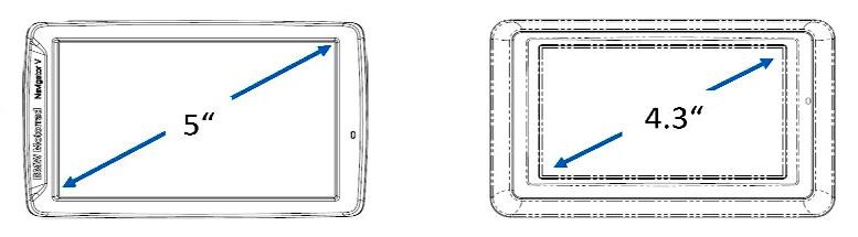
Larger screen than Navigator IV
The Navigator V will fit the existing GPS holder on K1600GT and K1600GTL and the 2014-later
R1200GS, R1200GS Adventure.
NOTE: Because of the bigger display, a new instrument cover (with a larger cut-out) is required
for the 2013 K1600GTL and K1600GTL. This cover is standard on 2014 models and will also
work with both the Navigator IV and Navigator V.
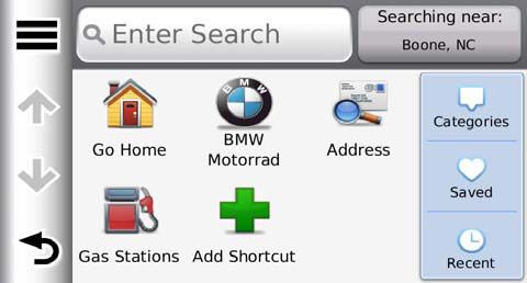
“Where To?” page is improved compared to Navigator IV
Don’t know how or where to find a destination? This is what the unit is searching near -
Type in the name of the destination here. you can change this to near your route,
your destination, etc.
All of the categories of
POI’s, your saved
waypoints and recent
destinations show up in
these menus.
Customize your favorites with shortcuts – you no longer
have to look through the menus to find a POI you
commonly search for.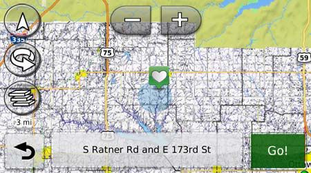
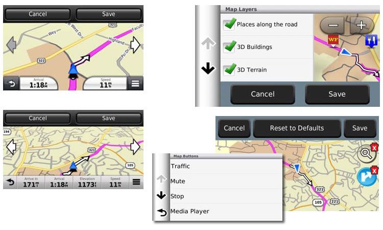
Features of the BMW Navigator V

Map Options
On the Navigator V there are many new ways to customize the map screen Change your
Dashboard, Map Buttons, Map Layers, Map Orientation, Vehicle Icon, Data Fields. Lets you see
what information you want to see and how you want to see it. 10 different Dashboard
configurations

Custom Maps
You can load custom maps to the Navigator V and maps can be photos you have taken, rally
maps, or scans of local DOT maps as shown here. The images must be geo-referenced with a
tool like Google Earth® and then loaded to the Navigator. For more instructions on Garmin
Custom Maps, see: http://www.garmin.com/us/products/onthetrail/custommaps#fragment-2
Features of the BMW Navigator V

Advanced route planning and navigation
New trip technology by means of Via and Shaping points make it possible to create longer and
more intricate motorcycle tours. A trip consists of up to 30 routes (segments). Each route has a
Via point and up to 125 Shaping points (Shaping points are used to define the route without being
announced as an intermediate destination during navigation such as a waypoint). The individual
segments (routes) are calculated in order to calculate the trip. This makes calculation and na
vigation faster, and makes it possible to skip individual segments.

Comparison:
Navigator IV: No trip planning but route planning with up to 250 points per route.
Navigator V: trip planning with up to 3750 points per trip (30 routes with 125 points each).
                                                                (Note: Blue dots are shaping points.)

Navigation announcements with natural guidance
Route description with exact environment description that uses orientation points such as traffic
lights, traffic signs, bridges and buildings.
Announcements such as "Turn left in 100 feet" may be replaced by "Turn left before the yellow
church". (Not for all countries.)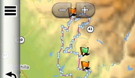
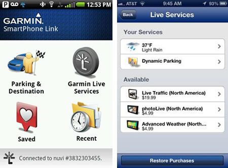
Features of the BMW Navigator V

Smart phone link
Allows users to wirelessly sync Navigator V to their Android or Apple smart phone to access
Garmin Connected Services. Download of the free Smartphone Link app is available in the
Google Play Store for Android or in the iOS App Store for iPhone.

After pairing your smartphone and the Navigator V, the app contents (such as Basic Weather)
that are available become visible on the Navigator. Subscription based Live Services such as
Advanced Weather and 3D Live Traffic can also be purchased via Smartphone Link. You can
also search for destinations with the Smartphone Link on the smartphone and send them to
Navigator V.

Included Services:
Weather
Address Sharing
Dynamic Parking
Last Mile Navigation

Premium Services:
Real Time Traffic
Photo Live Traffic Cameras
Advanced Weather
(Radar, Alerts, Road Conditions)
Highway Safety Cameras
Fuel Prices

You can download the free Smartphone Link App for your smart phone from the Google Play
store or the iOS App Store with your phone or with the Garmin navigation device the user can
then pair their devices together. Upon pairing, the Smartphone Link app will recognize the Garmin
device and start sharing the free services included with the app.

You can also purchase premium services like Advanced Weather or Fuel Prices through the
Smartphone Link app. The subscription would then enable the feature on your Navigator V.
(Billing is handled through the app market on your phone like any other app.)
Features of the BMW Navigator V

Exit Services
Exit Services allows you to search for POI’s along the interstate or major highway along your ride.
It only looks at POI’s within a short ride from the actual highway exit so that you can save time
side tracking off the interstate. With the search feature you can check exits further up the highway
you are on or along the highways the unit is routing you. This feature can be set as a map button
for quick access.

Bluetooth Menu
The Navigator V has an easier to use Bluetooth menu. Now you can pair to your phone or have
your phone pair to the Navigator. If you only want to have your phone paired for Smartphone link
but not phone calls you can now select that as well.

Features of the BMW Navigator V

My Motorcycle Pages (R1200GS, R1200GS Adventure only)
“My Motorcycle pages” works only on 2014
R1200GS or R1200GS Adventure models.

The My Motorcycle Pages are only available
if appropriate LIN messages with on-board
computer content or motorcycle data are
(or have been) transmitted by the instrument
cluster. There are 3 different My Motorcycle
pages: My Motorcycle, My Motorcycle status,
My Motorcycle Last Ride.

                                                      With My Motorcycle Page riders can view
                                                        real time information from their bike. The
                                                        page can be configured for multiple data
                                                    field layouts and the unit can re-arrange the
                                                         data in the order they would like to see.

                                                     This data is fed via the LIN Mount standard
                                                      on the K50/K51 bike with Navigation prep.
                                                        This will not work in the 4 button mount.

Last Ride Analyzer lets you view motorcycle data
and trip conditions and statistics from your
last ride with the Navigator V. This feature
is accessible when the Navigator V is off the
bike.

Available information includes: Trip odometer,
average speed, average fuel consumption,
maximum/average bank, curve counter,
gearshifts, average accelerator throttle position,
front/rear brake operation, maximum / minimum /
average ambient temperature, average engine
temperature. Statistics and Temperatures can be reset separately.

                                                       With The Motorcycle status page riders
                                                         can view vehicle information fed to the
                                                       Navigator V via the LIN bus when off the
                                                       bike. It allows a quick glance of the most
                                                                   recent snap shot from the bike.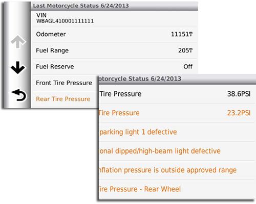
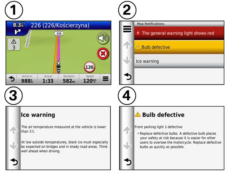
Features of the BMW Navigator V

Warning and status messages
Motorcycle warning and status messages are displayed with an appropriate symbol at the top left
on the main map page (1).

If several warning messages are active, the number of messages is shown below the warning
triangle. If a connection to the BMW Motorrad communication system is active, a new message
is signaled by an acoustic warning in the helmet.

If multiple messages are present, pressing the warning triangle opens a list containing all warning
messages (2).

If a message is selected, additional information is displayed (3, 4).

If the fuel reserve is selected, the closest filling stations in the area are displayed. Displayable
contents: red warning light, yellow warning light, fuel reserve, ABS status, ASC status, tire
inflation pressure warning, lighting fault, low engine oil level
You can also read