Fit-For-Purpose Land Administration - FIG GUIDE - JOINT FIG / WORLD BANK PUBLICATION
←
→
Page content transcription
If your browser does not render page correctly, please read the page content below
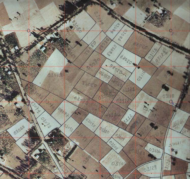
FIG GUIDE
FIG PUBLICATION
NO 60
Fit-For-Purpose Land Administration
JOINT FIG / WORLD BANK PUBLICATION
INTERNATIONAL FEDERATION WORLD BANK
OF SURVEYORS (FIG)
Fit-For-Purpose Land Administration
       JOINT FIG / WORLD BANK PUBLICATION

                   Stig Enemark
                 Keith Clifford Bell
                Christiaan Lemmen
                  Robin McLaren

     INTERNATIONAL FEDERATION OF SURVEYORS (FIG)
Copyright © The World Bank and the International Federation of Surveyors (FIG) 2014.
All rights reserved.
International Federation of Surveyors (FIG)
Kalvebod Brygge 31–33
DK-1780 Copenhagen V
DENMARK
Tel. + 45 38 86 10 81
E-mail: fig@fig.net
www.fig.net
Published in English. 2nd print (1st print in 2014).
Copenhagen, Denmark
ISSN 1018-6530 (printed)
ISSN 2311-8423 (pdf )
ISBN 978-87-92853-10-3 (printed)
ISBN 978-87-92853-11-0 (pdf)

Published by
International Federation of Surveyors (FIG)
DISCLAIMER
The designations employed and the presentation of material in this publication do not imply the expression of any opinion
whatsoever on the part of the World Bank concerning the legal status of any county, territory, city or area or its authorities, or
concerning the delimitation of its frontiers or boundaries regarding its economic system or degree of development. Excerpts
may be reproduced without authorization, on condition that the source is indicated. Views expressed in this publication do
not necessarily reflect those of the World Bank.

Front cover photos left: Rio de Janeiro, Brazil; mid: Ghana; right: Nepal.
Back cover photo: Malawi. All photos © Stig Enemark.
Editor: Stig Enemark
Layout: Lagarto
Printer: 2015 Libris Oy, Helsinki, Finland

CONTENTS

1 FOREWORD........................................................................................................................................ 5

2 EXECUTIVE SUMMARY................................................................................................................. 6

3 DECLARATION ................................................................................................................................. 8

4 INTRODUCTION............................................................................................................................... 9

5 THE FIT-FOR-PURPOSE CONCEPT........................................................................................10

6 LAND GOVERNANCE...................................................................................................................13
       Supporting the global agenda...................................................................................................14
       Providing responsible governance of tenure.......................................................................15
       In summary.......................................................................................................................................17

7 BUILDING FIT-FOR-PURPOSE LAND ADMINISTRATION SYSTEMS.....................19
       The Spatial Framework..................................................................................................................19
       The Legal Framework....................................................................................................................23
       The Institutional Framework.......................................................................................................24
       Discussion..........................................................................................................................................24
       Cases (Rwanda, Namibia, Eastern Caribbean, Ethiopia, Indonesia)..............................27

8 CAPACITY DEVELOPMENT FOR LAND ADMINISTRATION.......................................32

9 THE WAY FORWARD.....................................................................................................................34

REFERENCES...........................................................................................................................................36

ABOUT THE AUTHORS.......................................................................................................................38
1    FOREWORD

This publication is the result of cooperation between the World Bank and the Inter-
national Federation of Surveyors (FIG) over recent years to address the issue of build-
ing and sustaining land administration systems that are basically fit-for-purpose rather
than blindly complying with top-end technological solutions and rigid regulations for
accuracy.
The cooperation started by the joint FIG / World Bank conference in 2009 addressing
“Land Governance in Support of the Millennium Development Goals”. A report from
this conference can be found as FIG Publication No. 45 (FIG/WB, 2010).
At the following annual World Bank Conferences on Land and Poverty concerns were
raised by various stakeholders that the current procedures and requirements for map-
ping and boundary delineation were often too cumbersome and expensive and did
not comply with the actual needs of most citizens for achieving security of tenure. Fur-
thermore, many of the systems that have been established are costly to maintain and
operate and do little to improve service delivery and access to land information. These
concerns were subsequently addressed at several special seminars and workshops cov-
ering these issues including that of “Spatially Enabling Governments and Societies for
Sustainable Land Administration and Management”.
Emerging from these events is the concept of “fit-for-purpose” indicating that land ad-
ministration should be designed to meet the needs of people and their relationship
to land, to support security of tenure for all and to sustainably manage land use and
natural resources. This perspective calls for a flexible and pragmatic approach rather
than requirements imposed through rigid regulations, demands for spatial accuracy
and systems that may be unsustainable for less developed countries dependent on
donor funding. Of course, such flexibility allows for land administration systems to be
incrementally improved over time, should it be found necessary. This publication pro-
vides guidelines for the building of such fit-for-purpose land administration systems.
The publication presents an innovative, flexible approach that is jointly endorsed by
the World Bank and the International Federation of Surveyors.
We would like to acknowledge the efforts of the authors in providing this publication.
It is our hope that the fit-for-purpose approach will be widely applied throughout the
world and especially in less developed countries seeking to address issues such as pov-
erty alleviation, insecure access to land, inadequate shelter, social inequity and envi-
ronmental degradation.

                                CheeHai Teo               Klaus Deininger
                                FIG President             Lead Economist, World Bank

                                           5
2     EXECUTIVE SUMMARY

Land administration should be designed to meet the needs of people and their relation-
ship to land, to support security of tenure for all and to sustainably manage land use
and natural resources. However, the current solutions to delivering land administration
services have very limited global outreach; 75 percent of the world’s population do not
have access to formal systems to register and safeguard their land rights. The majority of
these are the poor and the most vulnerable in society. There is an urgent need to build
affordable and sustainable systems to identify the way land is occupied and used. FIG
and the World Bank have been cooperating on solutions to this global issue since 2009
and this fit-for-purpose approach to land administration has emerged as a game changer.
Fit-for-purpose means that the land administration systems – and especially the under-
lying spatial framework of large scale mapping – should be designed for the purpose
of managing current land issues within a specific country or region – rather than simply
following more advanced technical standards. The fit-for-purpose approach is partici-
patory and inclusive – it is fundamentally a human rights approach. Benefits relate to
the opportunity of building appropriate land administration systems within a relatively
short time and for relatively low and affordable costs. The fit-for-purpose approach be-
ing proposed here offers governments and land professionals the opportunity to make
a significant improvement in global land issues. It is a realistic approach that is scalable
and could make a significant difference in the intermediate timeframe. The cases pro-
vided in this report highlight just how successful this approach can be.
The term “fit-for-purpose” is not new at all, but what is new is relating this term to build-
ing sustainable land administration systems. Therefore, the approach used for building
land administration systems in less developed countries should be flexible and focused
on citizens’ needs, such as providing security of tenure and control of land use, rather
than focusing on top-end technical solutions and high accuracy surveys. A fit-for-pur-
pose approach includes the following elements:
    – Flexible in the spatial data capture approaches to provide for varying use and
      occupation.
    – Inclusive in scope to cover all tenure and all land.
    – Participatory in approach to data capture and use to ensure community sup-
      port.
    – Affordable for the government to establish and operate, and for society to use.
    – Reliable in terms of information that is authoritative and up-to-date.
    – Attainable in relation to establishing the system within a short timeframe and
      within available resources.
    – Upgradeable with regard to incremental upgrading and improvement over time
      in response to social and legal needs and emerging economic opportunities.
A country’s legal and institutional framework must be revised to apply the elements
of the fit-for-purpose approach. This means that the fit-for-purpose approach must be
enshrined in law, it must still be implemented within a robust land governance frame-
work, and the information must be made accessible to all users.

                                             6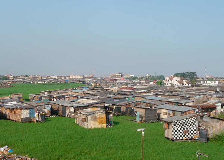
There is a general consensus that governing the people to land relationship is in the
heart of the global agenda. In this regard, it must be recognised that land governance
and the operational component of land administration systems need a cost effective
spatial framework of large scale mapping to operate. This will establish the link be-
tween people and land, and thereby enable management and monitoring of improve-
ments to meet the aims and objectives of adopted global and country based land
policies. This is where fit-for-purpose approaches provide crucial support in building
affordable and sustainable land administration systems. The fit-for-purpose approach
includes four key principles:
   – General boundaries rather than fixed boundaries. Using general boundaries
     to delineate land areas will be sufficient for most land administration purposes
     especially in rural and semi-urban areas. In the present context, the term “gen-
     eral boundary” means one whose position has not been precisely determined,
     although usually, the delineation will relate to physical features in the field.
   – Aerial imageries rather than field surveys. The use of high resolution satellite/
     aerial imagery is sufficient for most land administration purposes. This approach
     is three to five times cheaper than field surveys.
   – Accuracy relates to the purpose rather than technical standards. Accuracy
     of the land information should be understood as a relative issue related to the
     use of this information.
   – Opportunities for updating, upgrading and improvement. Building the spa-
     tial framework should be seen in a perspective of opportunities for on-going up-
     dating, sporadic upgrading, and incremental improvement whenever relevant
     or necessary for fulfilling land policy aims and objectives.
Ensuring advocacy for change and providing support to change management is a key
role for organisations like the World Bank, UN-FAO, UN-HABITAT, FIG and other land re-
lated professional bodies. The politicians and decision makers in the land sector are key
players in this change process. The hearts and minds of land professionals need to be
turned to fully understand and embrace the fit-for-purpose approach. Organisations
in the land sector need to ensure the awareness and up-to-date skills of their mem-
bers and staff. The largest change will be focused on the public sector where this may
involve institutional and organisational reforms, including legal framework, processes
and procedures, and awareness in terms of incentives and accountability.
To drive this change process there must be effective knowledge-sharing to ensure the
lessons learnt and good practices are widely implemented. It is hoped that this publica-
tion will pave the way forward towards implementing sustainable and affordable land
administration systems enabling security of tenure for all and effective management of
land use and natural resources. This, in turn, will enable political aims such as economic
growth, social equity and environmental sustainability to be better supported, pursued
and achieved.

                                            7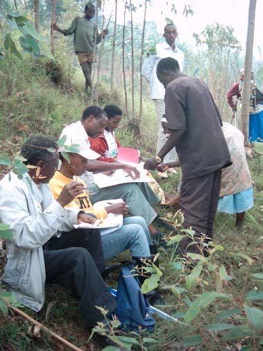
3     DECLARATION

    FIG-World Bank Declaration on
    Fit-for-Purpose Land Administration
    There is an urgent need to build cost-effective and sustainable systems which
    identify the way land is occupied and used and accordingly provide for secure
    land rights. When considering the resources and capacities required for building
    such systems in less developed countries, the concepts of mature, sophisticated
    systems as predominantly used in developed countries may well be seen as the
    end target, but not as the point of entry. When assessing technology and invest-
    ment choices, the focus should be on a “fit-for-purpose approach” that will meet
    the needs of society today and that can be incrementally improved over time.
    A fit-for-purpose approach includes the following elements:
       – Flexible in the spatial data capture approaches to provide for varying
         use and occupation.
       – Inclusive in scope to cover all tenure and all land.
       – Participatory in approach to data capture and use to ensure community
         support.
       – Affordable for the government to establish and operate, and for society
         to use.
       – Reliable in terms of information that is authoritative and up-to-date.
       – Attainable to establish the system within a short timeframe and within
         available resources.
       – Upgradeable with regard to incremental improvement over time in re-
         sponse to social and legal needs and emerging economic opportunities.
    A country’s legal and institutional framework must be revised to apply the ele-
    ments of the fit-for-purpose approach. This means that the fit-for-purpose ap-
    proach must be enshrined in law and that the information be made accessible
    to all users.
    A fit-for-purpose approach will ensure that appropriate land administration sys-
    tems are built within a relatively short time frame and affordable costs. The sys-
    tems allow for incremental updating and upgrading. This approach will facilitate
    economic growth, social equity and environmental sustainability to be better
    supported, pursued and achieved.

                                            8
4 INTRODUCTION
The current solutions to delivering land administration services have very limited
global outreach; 75 percent of the world’s population do not have access to formal
systems to register and safeguard their land rights. The majority of these are the poor
and the most vulnerable in society and without any level of security of tenure they
constantly live in threat of eviction. For example, foreign investors through large scale
land acquisitions have attained more than 30 million hectares of land in largely poor
and middle-income countries since 2000; many indigenous people have lost rights to
their land. This creates significant instabilities in society and severely limits their ability
to participate in economic development.
The pressure to change and provide more appropriate and efficient land administra-
tion services and strengthen security of tenure is growing within global political circles.
Land was prominent on the agenda for the G8 and G20 meetings in 2013 and land
indicators are planned within the replacement of the Millennium Development Goals
(UN, 2013). The ability of the current land administration paradigm to quickly scale up
to engage the excluded 75 percent of the world’s population is impossible. It is time to
rethink how land rights are recorded and managed.
The key bottleneck in land administration services is the use of traditional, high accu-
racy, expensive land surveying techniques to record land rights. However, the adoption
of ‘spatially-fit-for-purpose’ and the ‘continuum-of-continuums’ concepts will introduce
flexibility and fundamentally change how land professionals record land rights. This ap-
proach provides a profound opportunity for the profession to positively react to these
global land policy agenda challenges.
This report provides a comprehensive overview of the ‘fit-for-purpose’ approach by ini-
tially setting the land governance and global land policy agenda context, describing
how to build fit-for-purpose land administration systems, recognising the benefits of
implementing the approach, identifying the potential constraints and barriers for its
adoption, highlighting the associated opportunities for land professionals and finally
describing the capacity building required to achieve widespread adoption and secure
tenure for all.
95 THE FIT-FOR-PURPOSE CONCEPT
There is an urgent need to build simple, basic and sustainable systems using a flexible
and affordable approach to identifying the way land is occupied and used. When con-
sidering the resources and capacities required for building such systems and the corre-
sponding basic spatial frameworks available in less developed countries, the concepts of
mature, sophisticated systems as predominantly used in developed countries, may well
be seen as the end target rather than the point of entry. When assessing technology and
investment choices, the focus should be on a “fit-for-purpose approach” that will meet the
needs of society today and can be incrementally improved over time (Enemark, 2013).
The term “fit-for-purpose” is not new at all. What is new is to relate this term to building
sustainable land administration systems. The term “fit-for-purpose land administration”
indicates that the approach used for building land administration systems in less devel-
oped countries should be flexible and focused on serving the purpose of the systems
(citizens’ needs such as providing security of tenure and control of land use) rather than
focusing on top-end technical solutions and high accuracy surveys.
Flexibility is the key characteristic. It is about flexibility in terms of demands for accu-
racy, demands for spatial information and recording of legal and social tenure, and in
shaping the legal framework to accommodate societal needs.
Another key characteristic is incremental improvement. The systems should be de-
signed for initially meeting the basic needs of society today and have the capability to
be incrementally improved over time in response to social and legal needs economic
development, investment and also financial opportunities that may emerge over the
longer term. Using a fit-for-purpose approach does not limit ambitions for an ultimate
solution, e.g. solutions in line with some advanced systems used predominantly in de-
veloped countries.
The basic components of the fit-for-purpose concept are threefold:
1. Using affordable modern technologies for building a spatial framework,
e.g. orthophotos, showing the way land is occupied and used. The scale
and accuracy of the mapping may vary according to building density,
topography and other requirements.
2. Based on the spatial framework, using a participatory approach to
identifying and recording the various legal and social tenure rights
associated with occupancy and use of the land.
3. Adopting a legal framework that accommodates the flexibility necessary
for implementing a fit-for-purpose approach. This framework may be
established up front or it may be developed incrementally.
The concept and the basic components are described in details in section 7.
The fit-for-purpose concept directly supports what is called “Continuum of Continu-
ums”. This term occurred in response to the view that the traditional cadastral systems –
10as known in most developed countries and which often operate with fixed (high level)
technical standards and a legal perspective – predominantly support freehold as the
sought after form of tenure.
The concept “Continuum of Continuums” has many continuum dimensions:
– It recognizes that a continuum of tenure exists in terms of social tenure
relationships, such as occupancy, usufruct, informal rights, customary
rights, indigenous right and nomadic rights. In the same way, parties
holding the rights may not only be natural or legal persons, but could be
a family, tribe, community, village, or a farmers´ cooperative.
– Also the spatial unit may not only be a land parcel, but can also vary ac-
cording to where the rights and social relationships apply, e.g. a point
cadastre rather than a parcel boundary, or it could be text based or photo
based.
– Similarly, one may talk about a continuum of data acquisition methods
or technologies that will include what could be called “continuum of ac-
curacy”.
– Another dimension could be a continuum of land recording and credit
accessibility, ranging from informal land offices in an informal settlement
to a governmental land registry.
The key point is that the systems should enable secure land rights for all and cover all
land as a basis for land valuation and land use control. That also means securing the
rights of the land held by the state. At the outset, the systems may vary from being very
simplistic in some (rural) areas of the country while other (densely populated) areas
are covered by more accurate and legally complete applications, especially where land
is of high value and in short supply. Through updating and upgrading procedures the
systems can then, in turn, develop into modern and fully integrated systems for land
information and administration, where appropriate.
The change process necessary for implementing a fit-for-purpose approach to land ad-
ministration can start today. Legal flexibility should be introduced as a basis for identi-
fying and recording the spatial units in a more flexible way. The spatial framework, e.g.
orthophotos – showing the way land is divided into specific plots for occupancy and
use – can then be developed using a flexible approach and the various legal and social
tenure rights can be recorded in a participatory way.
A key demand, of course, relates to developing the necessary capacity for building and
running the systems (see section 8). Another demand is about establishing the budg-
etary base, e.g. through development aid support such as through the World Bank.
And, most importantly, there is a fundamental requirement for strong political will and
leadership. However, recent experiences show that it is possible – Rwanda, for example,
has covered the whole country using a fit-for-purpose approach within 5 years and for
a cost of around 6 USD per parcel/spatial unit.
The fit-for-purpose approach implies that the role of the land professionals will signifi-
cantly change. Field work will increasingly be undertaken by local field staff given the
11necessary short term training – while the land professionals will mainly oversee and
manage the process and ensure that all aims, objectives and regulations are complied
with. However, the land professionals will also benefit from this change through en-
larging their base of services to include the total country population.
The fit-for-purpose approach is participatory and inclusive – it is fundamentally a hu-
man rights approach. Further benefits relate to the opportunity of building appropriate
systems within a relatively short time and for relatively low and affordable costs. This
will enable political aims such economic growth, social equity and environmental sus-
tainability to be better supported, pursued and achieved. However, the fit-for-purpose
approach must still be implemented within a robust land governance framework.
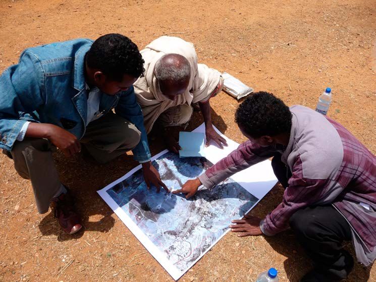
© Christiaan Lemmen
Identification of parcel boundaries on an aerial imagery, Ethiopia.
126 LAND GOVERNANCE
All countries have to deal with governing their land. They have to deal with the gov-
ernance of land tenure, land value, land use and land development in some way or
another. A country´s capacity may be advanced and combine all the activities in one
conceptual framework supported by sophisticated Information and Communication
Technology (ICT) models or, more likely, capacity will be involved in very fragmented
and basically analogue approaches.
Land governance is about the policies, processes and institutions by which land, prop-
erty and natural resources are managed. Sound land governance requires a legal regu-
latory framework and operational processes to implement policies consistently within
a jurisdiction or country, in sustainable ways. Land administration systems provide a
country with an infrastructure for implementing of land policies and land management
strategies in support of sustainable development.
Such land administration systems need a spatial framework to operate. This framework
may be very sophisticated and included as a basic layer of interactive land information
systems, or, as suggested by the fit-for-purpose approach, it may be just an satellite/or-
thophoto imagery showing the way land is divided in to plots for specific use and pos-
session. A global perspective for land management and governance is shown in Figure 1.
The operational component of the land management concept is the range of land ad-
ministration functions that include the areas of: land tenure (securing and transferring
rights in land and natural resources); land value (valuation and taxation of land and
properties); land use (planning and control of the use of land and natural resources);
and land development (implementing utilities, infrastructure, and construction plan-
ning). These four functions interact to deliver overall policy objectives, and they are
facilitated by appropriate land information infrastructures that include cadastral and
topographic datasets linking the built and natural environment. Ultimately, the design
of adequate systems of land tenure and land value should support efficient land mar-
kets, and adequate systems of land use control and land development should lead to
Figure 1: A global land management perspective (Williamson et.al., 2010).
13effective land use management. The combination of efficient land markets and effec-
tive land use management are seen as a key component in delivering economic, social
and environmental sustainability.
Sound land administration systems deliver a range of benefits to society in terms of:
support of governance and the rule of law; alleviation of poverty; security of tenure;
support for formal land markets; security for credit; support for land and property taxa-
tion; protection of state lands; management of land disputes; and improvement of land
use planning and implementation. The systems enable the implementation of land
policies to fulfil political and social objectives and to achieve sustainable development.
Supporting the global agenda
Good land governance should be seen as a means of supporting the global agenda.
This relates to the global partnership for sustainable development as established
through the UN Agenda 21 with a global action plan for sustainable development into
the 21st century. This action plan is a process that aims to meet the needs of the present
generation without harming the ability of future generations to meet their needs (UN,
1992). In striving for sustainability most countries have recognised the importance of
the fundamental relationship between people and land. Sound land governance and
administration – whether organised through advanced information systems or estab-
lished through more basic fit-for-purpose approaches – provides the tool for managing
this people to land relationship in a sustainable way.
Another cornerstone in the global agenda is The Millennium Development Goals
(MDGs) that form a blueprint agreed to by all the world’s countries and the world’s
leading development institutions. The first seven goals are mutually reinforcing and
are directed at reducing poverty in all its forms. The last goal – global partnership for
development – is about the means to achieve the first seven. To track the progress in
achieving the MDGs a framework of targets and indicators has been developed. This
framework includes 18 targets and 48 indicators enabling the on-going monitoring
of the progress that is reported annually (UN, 2000). As the world now heads into the
post-2015 development era, the achievement of the MDGs, especially in conflict and
fragile states lags well behind and in fact the majority of MDG targets will not be met in
such states (World Bank, 2013a).
The MDGs do not mention land governance or security of tenure in specific terms.
However, the MDGs represent a wider concept or a vision for the future, where the con-
tribution of good land governance is vital. This perspective will also continue for the
post 2015-development agenda for “Sustainable Development Goals” where indicators
are currently being considered for measuring the further progress, e.g. in relation to
secured land rights, equal rights of women, and legal recognition of the continuum of
land rights.
The MDGs are also a good example of the phrase: “If we can measure it – we can
better it”. This phrase relates to the fact that without a road map for measuring the
progress, most UN or government pronouncements will have little impact and are
easily forgotten – no matter how well-meaning they may be. But by monitoring and
documenting the on-going progress, governments can justify activities and associ-
ated costs and can also more easily attract donor funding toward meeting the coun-
try specific targets.
14Another good example of measuring and monitoring is the Land Governance Assess-
ment Framework (LGAF) developed by the World Bank in conjunction with UN and oth-
er partners. The LGAF provides a holistic diagnostic review at the country or regional
levels that can inform policy dialogue in a clear and targeted manner. This quick and
innovative tool to monitor land governance is built around seven main areas for policy
intervention: legal and institutional frameworks for rights recognition and enforce-
ment; land use planning, land management and taxation; management of public land;
public provision of land information; dispute resolution and conflict management;
large scale land acquisition of land rights; and forestry. The LGAF helps policymakers
and other stakeholders to make sense of the technical levels of the land sector, bench-
mark governance, prioritize reforms in the land sector and identify areas that require
further attention (World Bank, 2011). Further examples are the annual World Bank “Do-
ing Business” reports (World Bank 2013b) and the annual Corruption Perception Index
(Transparency International, 2013).
Furthermore, sound land governance is also a key means to address global challenges
such as climate change, disaster risk management, food scarcity, and rapid urbanisation.
Providing responsible governance of tenure
Landownership and secure tenure can be a vital source of capital, which opens per-
sonal or group credit markets, leads to investments in land buildings, provides a social
safety net, and transfers wealth to the next generation. However, in several less devel-
oped countries most people do not have legal documents for the land they occupy
or use and thereby fall outside the formal management system. This means that most
decisions are made without information. This causes dysfunctional management of ur-
ban and rural areas from the household up to government level, which impair the lives
of millions of people (UN-HABITAT, GLTN, 2012). Sound land governance is the key tool
for dealing with security of tenure.
In less developed regions such as Sub-Saharan Africa, more than two thirds (in some
countries up to 90 percent) of the land is outside the formal systems of land adminis-
tration. This means that the existing formal systems do not serve the millions of peo-
ple whose tenures are predominantly social rather than legal. Unless an appropriate
legal framework is provided, social tenure provides no protection. This is now being
addressed through the Africa Land Policy Initiative and also the World Bank agenda for
improving land governance in Africa (see box on “Africa on the Move”).
UN-HABITAT has developed an innovative approach through the so-called Social
Tenure Domain Model (FIG/GLTN, 2010) that includes a “scaling up approach” with a
range of steps from informal to more formalised land rights. Furthermore, responsible
governance of tenure is now incorporated as part of the global agenda through the
recently published Voluntary Guidelines on Responsible Governance of Tenure (FAO,
2012). The Guidelines represent a global consensus on internationally accepted prin-
ciples and standards for responsible practices. The Guidelines promote secure tenure
rights and equitable access to land (including forests and fisheries) as a means of eradi-
cating hunger and poverty, supporting sustainable development and enhancing the
environment. However, in order for the Guidelines to be effective in any jurisdiction,
they require political will and commitment to good governance by the governments
at all levels.
15Africa on the move
Sub-Sahara Africa is often referred to as an underdeveloped region with a great potential.
Many land professionals having visited the region would agree to that. But Africa is now
on the move.
Economic growth in Sub-Sahara Africa is considerable with a rate of above 5 percent
per year for more than a decade. Projections by the World bank indicate that this will
continue for the years ahead while the global economy will grow at only 2.5 percent (and
only about 1 percent in Western economies). So Africa is expected to grow twice as fast
as the global economy.
However, Sub-Sahara Africa is still mostly poor and has been unable to translate its recent
robust growth into rapid poverty reduction. Compared to other less developed regions,
Sub-Sahara Africa has generally been left behind and is struggling with issues such as
insecurity of tenure, informal settlements and urban slums, landownership inequalities
and landlessness, and degrading of natural resources. These facts indicate that poor land
governance, including the manner in which land rights are defined and administered,
may well be the root of the problem.
In recent years significant progress has been achieved in countries such as Rwanda and
Ethiopia through comprehensive land reform projects and other African countries are
following in their footsteps. At the regional scale the challenges are addressed by setting
a promising agenda for Africa and by focusing on sustainable land governance as the
core means of achieving the goals. The overarching agenda is set by the African Union,
the African Development Bank, and the UN Economic Commission for Africa. It has been
adopted by the African leaders through two seminal documents “Declaration on land Is-
sues and Challenges in Africa” (2009) and the “Framework and Guidelines on Land Policy
in Africa” (2010).
But developing land policies is not an end in itself – they need to be effectively imple-
mented. This relates to land reform programmes, land administration infrastructures and
building transparent and sustainable institutions. This process of implementation is fa-
cilitated by a capacity development framework currently being developed by the Global
Land Tool Network (GLTN) as part of the Land Policy Initiative (LPI).
Furthermore, in July 2013 the World Bank released a report on “Securing Africa´s Land
for Shared Prosperity”. This publication presents a ten-point programme to scale up land
policy reforms and investments for improving land governance in Sub-Saharan Africa.
The key elements include: improving tenure security and land access; increasing efficien-
cy and transparency in land administration services; developing capacity in land admin-
istration; and increasing scope and effectiveness of land use planning. The programme
indicates that it would cost African countries and their development partners, including
the private sector, USD 4.5 billion spread over 10 years to scale up these policy reforms
and investments. This sounds like an extremely good bargain.
The possible merging of these initiatives will set a new and very promising agenda for Af-
rica by changing the focus from projects on just issuing titles to a more holistic approach
to land governance, including institutional development and the connected capacity
building activities. This is basically a human rights approach and should be strongly sup-
ported by the global community of land professionals. Let´s all embrace that Africa is on
the move…
Stig Enemark, GIM International, October 2013.
16The Guidelines outline principles and practices that governments can refer to when
making laws and administering land, fisheries and forests rights. While the Guidelines
acknowledge that responsible investments by the public and private sectors are essen-
tial for improving food security, they also recommend that safeguards be put in place to
protect tenure rights of local people from risks that could arise from land grabbing, and
also to protect human rights, livelihoods, food security and the environment. The Guide-
lines thereby place tenure rights in the context of human rights such as the right to ade-
quate food and housing. With the help of the Guidelines a variety of actors can determine
whether their proposed actions and the actions of others constitute acceptable practices.
In summary
The global land agenda as presented above is driven mainly by the UN and its agen-
cies such as UN-FAO, UN-HABITAT and the World Bank. It must be noted though, that
a range of other agencies, such as civil society organisations, and NGOs (non-govern-
mental organisations) are strongly involved in supporting and driving this agenda. This
includes IFAD (International Fund for Agricultural Development); UNGGIM (UN Initia-
tive on Global Geospatial Information Management); ILC (International Land Coalition);
Slum Dwellers International; FIG (International Federation of Surveyors); GSDI (Global
Spatial Data Infrastructure Association), and others. Furthermore the agenda is sup-
ported by political clusters such as G8 who at their 2013 meeting endorsed the global
agenda for Responsible Governance of Tenure and the Open Data Charter (G8, 2013).
There is a general consensus that governing the people to land relationship is in the
heart of the global agenda. In this regard, it must be recognised that land governance
and the operational component of land administration systems need a cost effective
spatial framework of large scale mapping to operate. This will establish the link be-
tween people and land, and thereby enable management and monitoring of improve-
ments in relation to meeting aims and objectives of adopted global and country based
land policies. This is where fit-for-purpose approaches provide crucial support. Such
a fit-for-purpose approach to building affordable and sustainable land administration
systems is outlined in section 7.
17© Stig Enemark
Peri-urban developments, Lagos, Nigeria.
© Stig Enemark
Favela developments, Rio de Janeiro, Brazil.
187 BUILDING FIT-FOR-PURPOSE
LAND ADMINISTRATION SYSTEMS
Fit-for-purpose means that the land administration systems – and especially the under-
lying spatial framework of large scale mapping – should be designed for the purpose
of managing current land issues within a specific country or region – rather than sim-
ply following more advanced technical standards. The land administration functions,
as mentioned above and as shown in Figure 1, may place different requirements on
accuracy and this again may vary depending on the context of geography and den-
sity of the use of land. Security of tenure does not in itself require accurate surveys of
the boundaries. However, the important aspect is identification of the land object in
relation to the connected legal or social right. The accuracy required for the purpose
of planning and management of the use of land also varies considerably for different
kinds of rural land uses versus the higher density of built up urban areas, and the same
is the case for valuation and taxation of high value building sites versus marginally used
rural areas. Such a flexible approach to building land administration systems also re-
lates to the legal and institutional frameworks.
The Spatial Framework
The spatial framework is the basic large scale mapping showing the way land is divided
into spatial units (such as parcels and plots) for specific use and occupancy. It provides
the basis for dealing with land administration functions such as: recordation and man-
agement of legal and social tenure; assessment of land and property value and taxa-
tion; identification and management of current land use; planning for future land use
and land development; delivery of utility services; and administration and protection
of natural resources (see Figure 1).
In many developed regions of the world this countrywide spatial framework has been
developed over about two centuries as large scale cadastral mapping and maintained
through property boundary surveys conducted to a high accuracy according to long
standing regulations and procedures. When considering the resources and capacities
required for building spatial frameworks in less developed countries, the concepts pre-
dominantly used in developed countries may well be seen as the end target, but not
as the point of entry. Using such advanced technical standards of adjudication, bound-
ary marking and field surveys are far too costly, too time consuming and capacity de-
manding, and in most cases simply not relevant, for providing an initial suitable spatial
framework. The focus should therefore be on methods that are fast, cheap, complete,
and reliable. The spatial framework can then be upgraded and updated whenever nec-
essary or relevant in relation to land development and management activities. Also,
the framework may well include volunteered information provided by citizens (crowd
sourcing) where authoritative data are not required or available (McLaren, 2013).
In relation to UN-HABITAT´s concept of the continuum of land rights, such a fit-for-pur-
pose approach could be referred to as a “continuum of accuracy”. The key focus should
be on providing secure tenure for all, and managing the use of land and natural resources
for the benefit of local communities and society as a whole. The fit-for-purpose approach
for providing the spatial framework can be outlined in four key principles:
19Four Key Principles
• General boundaries rather than fixed boundaries
In the present context, the term “general boundary” means one whose position
has not been precisely determined (although usually the delineation relates to
physical features in the field) while “fixed” means that it has been accurately re-
corded. Using general boundaries will be sufficient for most land administration
purposes especially in rural and semi-urban areas. Whereas fixed boundaries
will contribute mainly to interoperability between legal and physical objects in
advanced land information systems.
In the context of Sub-Sahara Africa – where only 30 percent of the land is in-
cluded in the formal land administration systems – it is argued that use of a
general boundary concept will be adequate and sufficient for incorporating the
remaining 70 percent under more formalised land administration procedures.
Fixed boundaries can then be used where relevant or necessary for any specific
purposes or when required and paid for by the landowner/stakeholders.
• Aerial imageries rather than field surveys
The use of high resolution satellite imagery (e.g. 50 cm pixels or better) or ortho-
photo imagery, e.g. in the scale of 1:2,000 for rural and low density areas; and
1:500 scale for dense urban areas, will be sufficient for most land administra-
tion purposes. The required scale of the mapping depends on topography and
density of development and may vary from large scale mapping in dense urban
areas to smaller scale imageries in rural areas and remote regions. Boundaries
can easily be identified on the imagery in most cases, depending on the vis-
ibility of the physical features. Experience, e.g. Ethiopia, shows that citizens have
good spatial cognizance. They can normally easily interpret the imageries, and a
participatory approach to boundary determination can then be easily applied.
The remaining smaller number of non-visual boundaries can be added using
hand held GPS or field survey measurements.
The use of imageries (including using Unmanned Aerial Vehicles – UAV) are con-
siderably cheaper than field surveys and do not require the capacity of trained
professionals to undertake the field work. It is estimated that compared to sat-
ellite / orthophoto imagery, field surveys are about three times more costly
in rural areas and about five times in urban areas. Furthermore, the mapping
methodology using imageries provides not only the spatial framework of spatial
units, but also the general topography of land use and buildings and infrastruc-
ture, that is fundamental for the planning and land development functions of
the land administration systems.
20• Accuracy relates to the purpose rather than technical standards
Accuracy of the land information such as the parcel boundaries, should be un-
derstood as a relative issue related to the use of this information, rather than be-
ing driven by technical standards that are often inflexible and “over the top” for
the purpose. In general, the need for accuracy is clearly lower in rural areas than
in densely built up and high value urban regions, where accurate field surveys
may be justified. But, more importantly, the need for accuracy of the various
features should be determined by the purpose of using this information for sup-
porting the various land administration functions. In this regard, the registration
of legal and social tenure rights requires identification of objects, but the pro-
cess does not call for a high accuracy in itself.
Also, planning and land development processes mainly require sufficient map-
ping for identifying physical and spatial objects rather than high accuracy per
se. Any demand for accuracy may stem from issues such as high land value in
dense urban areas or implementation of costly construction works. High accu-
racy through field surveys should therefore only be provided when needed and
be paid for by the beneficiaries.
• Opportunities for updating, upgrading and improvement
Building the spatial framework is not a one off process – it should be seen in a
perspective of opportunities for on-going updating, sporadic upgrading, and
incremental improvement whenever relevant or necessary for fulfilling land
policy aims and objectives. This of course requires that all mapping and surveys
are linked to a national grid system through a positioning infrastructure based
on the Global Navigation Satellite Systems (GNSS).
The requirement for on-going, updating procedures is essential in order to ensure
that all data are complete and reliable. Without such procedures the investments
are easily wasted over a relatively short period. The procedures should ensure
that any new boundaries or changes of existing boundaries are recorded through
measurements related to the existing boundaries or through provision of new im-
ageries e.g. by using UAVs once the subdivision boundaries are established.
The opportunity for upgrading should be adopted wherever possible and allows
for providing an improved map-base whenever needed for specific purposes,
such as land development activities, major construction works and implemen-
tation of major infrastructure. This allows for incremental improvement that, in
turn, will establish a spatial framework in line with modern and fully integrated
land information systems.
21The process for providing the spatial framework will include the following steps:
(i) Producing the satellite / orthophoto imagery at scales according to topography,
land use, and building density. The imagery itself can be used for many purposes
in relation to land use management processes, including compliance monitor-
ing of land development investment, forest degradation and land cover change.
(ii) The satellite / orthophoto imagery will be used in the field to identify, deline-
ate and adjudicate parcel boundaries (general boundaries), which can be drawn
directly on the imagery and the parcels be numbered for reference to the con-
nected land rights (see Figure 2). This is basically a participatory approach that
involves all local stakeholders.
(iii) The resulting boundary framework can be digitised from the imagery to create
a digital cadastral map to be used as a basic layer in the land information system
or in combination with the satellite imagery.
The digital cadastral map can be created either by scanning the field map with the de-
lineated boundaries and then digitising the boundary points from the map, or by using
Courtesy of Dr. Zerfu Hailu
Figure 2: Orthophoto used as a field work map sheet with a georeferenced grid. The map
shows the delineated parcel boundaries and parcel identification numbers. (Ethiopia).
22the field map to identify the boundaries and then digitising the boundary points from
the natural features as they appear on a digital orthophoto. The latter process is more
accurate but takes more skills and more sophisticated software.
Any boundary disputes can be resolved during the adjudication process where all rel-
evant stakeholders are present – or a special administrative body (rather than judicial)
may be established for this purpose. In the longer term, boundary disputes relate to
the way the boundary was determined when established in the system. It is therefore
important to store the relevant map information in archives for this purpose.
The Legal Framework
In most less developed countries the legal framework for land administration reflects
colonial times and often serves only the elite. The processes for land registration are
complex, costly, time consuming and with high demands for accuracy of boundary
surveys and often unnecessary legal interventions by notaries, lawyers and the court.
The existing legal framework is therefore often a significant barrier for implementing
a flexible approach to building land administration systems and the underlying spatial
framework as described above. So, as well as the spatial framework, the legal frame-
work should be flexible and be designed along administrative rather than judicial lines.
Furthermore, the legal framework and its institutions must support both legal and so-
cial tenure, ensure that flexible regulations are enshrined in the laws and support a
fit-for-purpose approach as described above.
It is recognized that the legal frameworks as used in developed countries do not serve
the millions of people whose tenures are predominantly social rather than legal. This
relates to the Continuum of Land Rights (Figure 3) where the range of possible forms of
tenure is considered as a continuum. Each continuum provides different sets of rights
and degrees of security and responsibility and enables different degrees of enforce-
ment (UN-HABITAT, GLTN 2008). As mentioned earlier, the figure does not imply that all
societies will or should necessarily develop into freehold tenure systems. Importantly,
the continuum of land rights indicates, that each step in the process can be formalised,
with registered freeholds offering a stronger protection, than at earlier stages.
Each form of tenure has benefits and limitations in different contexts. Customary sys-
tems can meet social and economic needs and, although often not documented, can
be very secure. However, this is often no longer the case as demand for communal
land has surged in response to increased private investments in natural resources. Land
grabbing and expropriation without proper compensation have been widely report-
ed. Scaling up policies and registration of communal lands would help to protect the
rights of local communities while reducing investment risks. By demarcating the outer
boundaries of village lands the allocation and management of individual plots could
be left to community institutions with the option to register individual rights as the
need arises (Byamugisha, 2013).
The Social Tenure Domain Model (STDM), as mentioned earlier, supports the continu-
um of land rights. The STDM is a concept rather than a software package. The concept
is flexible and enables all legal and social tenure rights to be captured (FIG/GLTN, 2010).
The STDM is a sub-version of the new ISO standard on Land Administration Domain
Model (ISO 19152, 2012) that presents a generic and inclusive solution as a way forward
for building flexible land administration systems.
23Figure 3: Continuum of land rights (UN-Habitat, 2008).
The Institutional Framework
This publication has focused on establishing the spatial framework covering all land
and enabling security of land rights for all. This is due to the concern raised about often
over-prescribed requirements for surveying and marking of boundaries that can be a
major barrier in terms of costs, time, and available capacity. However, in addition, there
is often an over-prescription of systems with high-end, expensive to maintain, enter-
prise geographic information systems and relational databases. Alternatives, such as
open source solutions should be considered, e.g. the UN-FAO Open Source Cadastre
and Registration Software (SOLA). Furthermore, the positioning/measuring equipment
and systems advocated by consultants and vendors is also often over-prescribed.
It is recognised, however, that establishing the institutional framework in terms of effi-
cient, accountable government workflows for making the systems operational is often
an even bigger, expensive obstacle. This issue relates to a large extent to the political
and administrative culture of the country and to the need for building sufficient capac-
ity at societal, organisational and individual levels. The issue of capacity development
is address in some detail in section 8.
Discussion
The discussion on building fit-for-purpose land administration systems – and especially
the underlying spatial framework – includes a range of issue where some of these are
clearly political while others relate to social equity, economic constraints, or profes-
sional standings. While most of these issues are touched upon above it is useful to ad-
dress some of the key questions that are often raised in this regard.
Why should less developed countries not have the same high level spatial frame-
work (or cadastral systems) as is common practice in developed countries? This ques-
tion is of course relevant. The response mainly relates to the fact that the framework
in most developed countries is developed over a period of about two centuries and
in response to societal, institutional and technological developments. Less developed
regions of course can´t wait for that. Building this spatial framework should be in re-
sponse to current societal needs and available economic resources. These needs will
be best addressed by adopting a fit-for-purpose approach as argued above, and the
spatial framework can then be incrementally improved over time in response to soci-
etal needs and development.
24What are the constraints and barriers for adoption of fit-for-purpose approaches?
Constraints and barriers are often perceived to be political constraints, colonial legacy,
lack of basic financial resources, and even lack of political will. This is compounded by
a legal framework with rigid regulations that does not allow for a more flexible ap-
proach. However, this may not be entirely true. Politicians will often rely on professional
bodies to advise on specific professional issues. These groups of professionals, such as
lawyers, surveyors, planners, etc., are highly educated and act as custodians of existing
land administration systems mainly developed by colonial powers and serving mainly
the elite. It is no surprise that their professional codes support the existing systems,
and there are many examples of resistance to change that will challenge their position.
However, by including all land in the formal land administration systems, the land pro-
fessionals will make a more significant contribution to social development and, at the
same time, also enlarge their functions and clientele.
What are the key benefits? Experience shows that a fit-for-purpose approach is adopt-
ed mainly when there is strong political leadership for change in support of secure land
rights for all. This kind of leadership, so to say, bypasses the professional arguments by
setting a deadline for completing the project of identification and registration of land
rights. By setting a firm deadline – say five years as was the case in Rwanda – there is no
way this can be accomplished using the traditional field surveys.
Instead, new approaches have to be developed while still meeting the overall land re-
form aim and objectives. In this situation, the fit-for-purpose approach is the obvious
choice. It is participatory and can be accomplished by using less professional personnel
in the field. The use of imageries/orthophotos enables a number of further uses for land
management, and the process is flexible to accommodate both in terms of accuracy
needs and budgetary allowance.
Benefits arise by achieving a functional system covering all land and people within
a short time, for relatively low and affordable costs, and supporting incremental im-
provement when relevant and required. This again will enable achievement of politi-
cal aims and objectives in relation to economic growth, social and gender equity, and
environmental sustainability.
What are the opportunities for Land Professionals? Even if the land professionals may
to some extent be reluctant to comply with this kind of fit-for-purpose approach, it
actually offers a range of opportunities. Firstly, the land professionals will obtain an in-
creased client base by being able to serve the total population rather than only a small
elite. Furthermore, the approach implies that land professionals will undertake a more
managerial role in relation to managing and using the land related data rather than just
creating them. The land professionals will be responsible of the process for establish-
ing the system and also for training, managing and supporting the locally trained staff
to carry out the field work. This managerial role also includes quality assurance and
auditing as well as custodians of land information management. In the longer term the
professional status of the land professionals will be improved through contributing to
the overall aims and objectives for societal development.
The profession is being seriously challenged to solve land issues faster. Land profes-
sionals are at a very significant juncture and if a comprehensive journey of change is
not successful then other professions or government generalists will most possibly fill
the vacuum. Land professionals need to seize this moment and great opportunity.
25You can also read