Flood Levels and Borderlines: Livestock Farming and Evictions Resistance at the !Garib/Orange River in Southern Africa - Arcadia
←
→
Page content transcription
If your browser does not render page correctly, please read the page content below
Flood Levels and Borderlines: Livestock Farming and Evictions Resistance at the
!Garib/Orange River in Southern Africa
Luregn Lenggenhager and Andrea Rosengarten

Summary
This article places the life history of an African livestock farmer on the banks of the !Garib/Orange river in Namibia in the context of the forced
removal threats he has faced in the apartheid and post-apartheid eras. Despite being excluded from land ownership opportunities throughout the
twentieth century and up to the present day, this farmer and his family have used their nuanced environmental knowledge of the river, its
position, and its flooding history to their advantage to maintain their livelihood. However, the unclear demarcation of the Namibian-South
African international border with respect to the river complicates the family’s present challenges.

For the last few hundred kilometers before flowing into the Atlantic Ocean, the !Garib or Orange River becomes
the border between Namibia and South Africa. It emerges as a narrow strip of vegetation in a vast semi-desert. In
this piece, we consider the life histories of stock farmers on the riverbanks of the !Garib/Orange. Removal
attempts directed against African farmers in both the apartheid and post-apartheid eras demonstrate the
persistence of racial inequality in land ownership in this region. Meanwhile, the farmers’ resistance strategies
highlight historical and contemporary opportunities at the river for transcending the racialized economic
structures of the borderland.

In the center of the story stands Willem Cloete,1 an elderly farmer, father of eight sons, and owner of about one
hundred goats, 50 cattle, and some sheep, who herds on the northern banks of the !Garib/Orange River, south of
the town of Warmbad. In the view of many white farm owners, past and present, Cloete is an illegal squatter—a
poor, landless African herder with no place in a modern, capitalist future. This trope disguises the fact that
Cloete is successful and resourceful. His small farming operation at the riverbank has helped put his sons
through university in Namibia and South Africa. Cloete describes his family history as one of frequent
movement along the river, following its changing patterns to optimize grazing. While he commands family
history with certainty up to the generation of his great-grandfather, Petrus “Karihenene” Cloete, born in 1895,
he knows that his great-grandparents’ ancestors were also riverside people of this region.

Lenggenhager, Luregn, and Andrea Rosengarten. “Flood Levels and Borderlines: Livestock Farming and Evictions Resistance at the
!Garib/Orange River in Southern Africa.” Environment & Society Portal, Arcadia (Summer 2020), no. 34. Rachel Carson Center for
Environment and Society. https://doi.org/10.5282/rcc/9115.
Print date: 18 February 2021 17:47:11
Willem Cloete and family members by their farm, looking due west over the !Garib/Orange River. Namibia lies to the north on the right
riverbank side, and South Africa to the south on the left riverbank side.
2020 Luregn Lenggenhager and Andrea Rosengarten

                 This work is licensed under a Creative Commons Attribution 4.0 International License .

Environmental and political events have significantly shaped the fates of Cloete and others living along the river
before him. Sometimes changes in the river flow (due to floods, droughts, or new dams) required shifts in
herding strategy, while the livelihoods of small African stock keepers were also continually disrupted by colonial
interventions and, later, policies of land dispossession and racial segregation. In Cloete’s nearby area, the
Homsdrift mission station had been founded at the turn of the twentieth century. It was part of a network of
new Catholic missions attempting to “civilize” the semi-nomadic hunters and herders of the region, in part by
incentivizing a permanently sedentary lifestyle. Missionaries solicited Africans to live close to the mission station,
where they could water their livestock at the only perennially flowing river in this arid territory.

Lenggenhager, Luregn, and Andrea Rosengarten. “Flood Levels and Borderlines: Livestock Farming and Evictions Resistance at the
!Garib/Orange River in Southern Africa.” Environment & Society Portal, Arcadia (Summer 2020), no. 34. Rachel Carson Center for
Environment and Society. https://doi.org/10.5282/rcc/9115.
Print date: 18 February 2021 17:47:11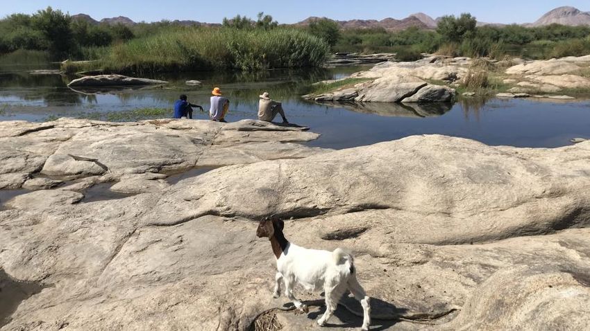
The Cloete goats are let out to graze. In the background are the family’s dwellings. Cloete expressed that the family has chosen not to
invest in building more permanent housing structures for fear that the neighboring farm owner will destroy them.
2020 Luregn Lenggenhager and Andrea Rosengarten

                  This work is licensed under a Creative Commons Attribution 4.0 International License .

However, the intensification of racialized land laws during South Africa’s occupation of Namibia (1915–1990)
gradually upended these semi-formal communal land agreements from earlier mission times.

Black people living along the river by Homsdrift were removed by the apartheid government beginning in the
1950s. In the 1970s the mission was closed and sold as private land to a white farmer. While many residents had
no choice but to accept resettlement and eventually employment as cheap black labor on white farms, the
Cloetes—along with about 10 other families—resisted removal and went upriver to more remote, rocky territory.
Since the apartheid era, members of the Cloete family have tended to their modest but profitable herds along this
more secluded section of river.

Although the Cloetes can demonstrate family occupancy since at least the late nineteenth century in the area,
they have never possessed official rights to the land they live on. The Cloetes, like the majority of black families in
the region, have not yet benefitted from Namibia’s post-apartheid land reforms. To this day, adjacent white
landowners consider the entire riverside area to be their own private land. Over the years they have destroyed
Cloete’s livestock enclosures and surveilled his movements. Tensions reached a high point in 2015 when the
owner of two farms (together more than 80,000 hectares) in the Homsdrift area sought to convert the land into a
profitable luxury lodge and “nature reserve” and also secure unspoiled access to the river for tourists. When the
Cloetes refused yet again to move, the farm-turned-hotel owner approached the Namibian courts to order their
eviction.

Lenggenhager, Luregn, and Andrea Rosengarten. “Flood Levels and Borderlines: Livestock Farming and Evictions Resistance at the
!Garib/Orange River in Southern Africa.” Environment & Society Portal, Arcadia (Summer 2020), no. 34. Rachel Carson Center for
Environment and Society. https://doi.org/10.5282/rcc/9115.
Print date: 18 February 2021 17:47:11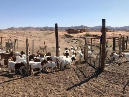
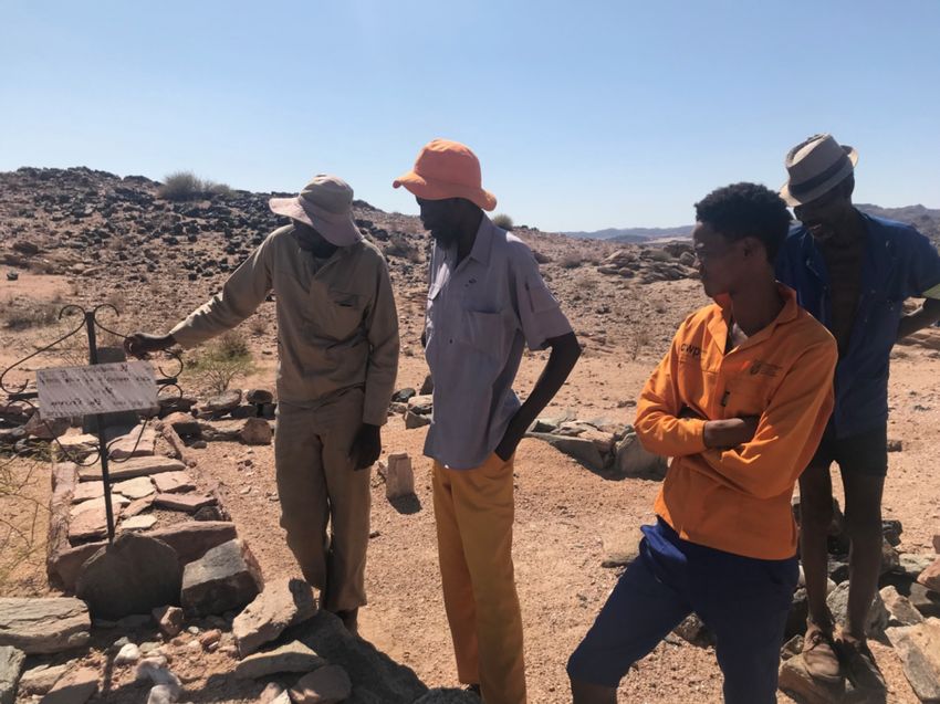
The Cloete family’s small cemetery on the grounds of their farm. Here, they visit the grave of Willem Cloete’s great-grandfather, b. 1895,
d. 1951.
2020 Luregn Lenggenhager and Andrea Rosengarten
This work is licensed under a Creative Commons Attribution 4.0 International License .
This 2015 case was more legally complicated than the farm owner had anticipated. The court proceedings
communicated that in the view of the Namibian government, the international border at this stretch of the river
was the high-water mark on the northern bank, based on historical floods. Therefore, the area between the river
and its flood marks could not be treated as the private lands of an individual landowner in Namibian court.
Cloete told us in January 2020 while showing us around his small riverside operation: “Look at the river sand in
the mountains—that shows where the private land of the farmer begins.” Indeed, the big flood of 1925 that he
had heard about from his grandfather produced sand deposit lines that are still visible in the landscape.
Lenggenhager, Luregn, and Andrea Rosengarten. “Flood Levels and Borderlines: Livestock Farming and Evictions Resistance at the
!Garib/Orange River in Southern Africa.” Environment & Society Portal, Arcadia (Summer 2020), no. 34. Rachel Carson Center for
Environment and Society. https://doi.org/10.5282/rcc/9115.
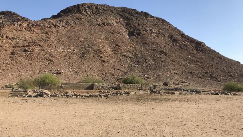
Print date: 18 February 2021 17:47:11The ruins of a cattle enclosure (kraal) on the former Homsdrift mission station grounds that the Cloete family made use of until late 2019.
Weeks before our January 2020 visit with Cloete, the kraal was destroyed by the neighbouring farm owner to prevent Cloete’s further use
of it.
2020 Luregn Lenggenhager and Andrea Rosengarten
This work is licensed under a Creative Commons Attribution 4.0 International License .
These deposits saved Cloete from eviction—at least for now. But they leave entangled questions about post-
apartheid restorative justice, international boundaries, land ownership, law, and environment unanswered. If the
land at the riverbanks is not private land, to whom does it belong? Moreover, in which country is it situated? The
South African government still considers people like Cloete living along the river’s northern banks to be
Namibian. Cloete is therefore maneuvering in a precarious limbo, living, and farming in an international no-
man’s-land without robust legal protections. He clarifies that he only seeks freedom of movement without
threats of violence, and the official allocation of this fertile territory along the riverbanks as communal land for
the historically dispossessed.
1
Surname has been changed.
Lenggenhager, Luregn, and Andrea Rosengarten. “Flood Levels and Borderlines: Livestock Farming and Evictions Resistance at the
!Garib/Orange River in Southern Africa.” Environment & Society Portal, Arcadia (Summer 2020), no. 34. Rachel Carson Center for
Environment and Society. https://doi.org/10.5282/rcc/9115.
Print date: 18 February 2021 17:47:11Further readings:
• Biwa, Memory. “Weaving the Past with Threads of Memory: Narratives and Commemorations of the Colonial War in
Southern Namibia.” PhD diss., University of Cape Town, 2012.
• Dicey, William. Borderline. Cape Town: Kwela Books, 2007.
• Hoffman, M. Timm, and Rick. F. Rohde. “Rivers Through Time: Historical Changes in the Riparian Vegetation of the
Semi-Arid, Winter Rainfall Region of South Africa in Response to Climate and Land Use.” Journal of the History of
Biology 44, no. 2 (2012): 59–80.
• Keegan, Timothy. Facing the Storm: Portraits of Black Lives in Rural South Africa. Cape Town: David Philip, 1988.
• Legassick, Martin. Hidden Histories of Gordonia: Land Dispossession and Resistance in the Northern Cape, 1800–1990.
Johannesburg: Wits University Press, 2016.
• Ramutsindela, Maano, Giorgio Miescher, and Melanie Boehi, eds. The Politics of Nature and Science in Southern Africa.
Basel: Basler Afrika Bibliographien, 2016.
• Van Onselen, Charles. The Seed is Mine: The Life of Kas Maine, a South African Share Cropper, 1894–1985. New York:
Hill and Wang, 1997.
Related links:
• Google maps image of Warmbad, Namibia https://www.google.com/maps/place/Warmbad,+Namibia/@-
28.9057206,19.0326733,45839m/data=!3m1!1e3!4m5!3m4!1s0x1c3c5e1645af495b:0x12e2468870327bb5!8m2!3d-28.44
90458!4d18.7333671
• Space in Time: Landscape Narratives and Land Management Changes in a Southern African Cross-Border Region
(University of Basel) https://zasb.unibas.ch/en/research/research-projects/space-in-time/
How to cite:
Lenggenhager, Luregn, and Andrea Rosengarten. “Flood Levels and Borderlines: Livestock Farming and
Evictions Resistance at the !Garib/Orange River in Southern Africa.” Environment & Society Portal, Arcadia
(Summer 2020), no. 34. Rachel Carson Center for Environment and Society. https://doi.org/10.5282/rcc/9115
.
This work is licensed under a Creative Commons Attribution 4.0 International License .
2020 Luregn Lenggenhager and Andrea Rosengarten
This refers only to the text and does not include any image rights.
Please click on the images to view their individual rights status.
ISSN 2199-3408
Environment & Society Portal, Arcadia
About the authors:
Luregn Lenggenhager
Luregn Lenggenhager is a historian at the Centre for African Studies (University of Basel). He is currently coordinating an
interdisciplinary research project on landscape narratives along the !Garib River. He recently published his doctoral thesis,
“Ruling Nature, Controlling People: Nature Conservation, Development and War in North-Eastern Namibia since the
1920s.”
Lenggenhager, Luregn, and Andrea Rosengarten. “Flood Levels and Borderlines: Livestock Farming and Evictions Resistance at the
!Garib/Orange River in Southern Africa.” Environment & Society Portal, Arcadia (Summer 2020), no. 34. Rachel Carson Center for
Environment and Society. https://doi.org/10.5282/rcc/9115.
Print date: 18 February 2021 17:47:11Andrea Rosengarten Andrea Rosengarten is a historian interested in race, segregation, and historical geography in colonial and apartheid Namibia. She is currently completing her PhD in African History at Northwestern University (USA). She is a recipient of the Fulbright-Hays DDRA research fellowship and the CLIR/Mellon Foundation fellowship for dissertation research in original sources. Lenggenhager, Luregn, and Andrea Rosengarten. “Flood Levels and Borderlines: Livestock Farming and Evictions Resistance at the !Garib/Orange River in Southern Africa.” Environment & Society Portal, Arcadia (Summer 2020), no. 34. Rachel Carson Center for Environment and Society. https://doi.org/10.5282/rcc/9115. Print date: 18 February 2021 17:47:11
You can also read