Future urbanists' Introduction January 2214 Floor 42 The Boris Johnson Tower
←
→
Page content transcription
If your browser does not render page correctly, please read the page content below
Londonmapper Future Urbanists’ Scheme of Work
Funded by RGS-IBG Innovative Geography Teaching Grant

LondonMapper: a short Scheme of Work

 “London is so old, so vast, so complex and kaleidoscopic in variety and changes that it is difficult so
        to describe it as to make the description a verbal or pictorial microcosm of the metropolis”
                                                                           Rt. Hon. John Burns (1930)

Future urbanists’ Introduction

January 2214
Floor 42
The Boris Johnson Tower

The teacher enters the classroom, pausing to look at the view spread out below her.
London.
The city sprawls outwards for as far as the eye can see, and beyond. Because of the heat haze and
high levels of brown haze – the distant horizon is shrouded. Glancing down she sees a small patch of
green, which represents all that remains of Hyde Park, and she can just make out the Royal
Geographical Society on the edge of it. She wonders what Shackleton would have made of the
changes he had seen as he stood on the corner of the building.
She turns to face her class. Their faces or avatars are projected onto the curved screen before her – a
few blank rectangles indicate students who have not yet logged into the classroom, but by the time
she has pulled up the materials that she intends to use, they are all present. She reminds them to
authenticate their location and identity (there have been cases where students have asked someone
else to sit exams for them or faked their avatars) and then brings up a series of bold images of London
which circle in mid-air before her: the Houses of Parliament, the new London Eye, the Queen
Elizabeth Stadium, Hoverport and Euston Transport Hub.
She sits on her floating chair, and with a glance at the clock she starts her lesson.
“Good morning class”.
“Today’s session of our course on Urban Geographies is focused on the city where I am sitting today.”
She polls the students as to which of them have visited London in person rather than virtually, and
asks them to share their experiences, which she collates into a rolling screen of text and contributed
multimedia material.
                                                          st
“We are going to look back at the early years of the 21 Century, when decisions were made which
resulted in some characteristics of the city that we see today taking shape.
At that time, the city was undergoing some challenges – some of which we have solved today and
others that remain. All cities are in constant flux. There have been many things written about London.
Which of them do you think are still true today?”
A series of quotes scroll across the screen, accompanied by a narration:

“When a man is tired of London, he is tired of life; for there is in London all that life can
afford.” - Samuel Johnson

“It is my belief, Watson, founded upon my experience, that the lowest and vilest alleys in
London do not present a more dreadful record of sin than does the smiling and beautiful
countryside.” – Sherlock Holmes (Arthur Conan Doyle)

“I don't know what London's coming to — the higher the buildings the lower the morals.” –
Noel Coward

“Paris is a woman but London is an independent man puffing his pipe in a pub.” – Jack
Kerouac

“London has the trick of making its past, its long indelible past, always a part of its present.
And for that reason it will always have meaning for the future, because of all it can teach
about disaster, survival, and redemption. It is all there in the streets.” – Anna Quindlen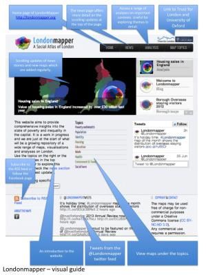
Londonmapper Future Urbanists’ Scheme of Work
Funded by RGS-IBG Innovative Geography Teaching Grant

“London, London, London town, You can toughen up or get thrown around.” – Kano

“You can't ever get bored of London ‘cos even if you live here for like a hundred and fifty
years you still won't ever know everything about it. There's always something new. Like,
you're walking round somewhere you've known since you was born and you look up and
there's an old clock on the side of a building you never seen before, or there's a little
gargoyley face over a window or something. Don't you think it's cool?” – Richard Rider

“I want you to know that I have nothing against Orlando (Florida), though you are, of
course, far more likely to get shot or robbed there than in London.” – Boris Johnson

“No matter what you want to do in London, there's a million others who are in the queue
ahead of you. Everything is always a hassle.” – Craig Taylor

“London in 2100 is in better health than at the start of the century. That in itself is a
miracle..” – Professor Ella Parkinson

“Can you find other quotes which add to this sense of the city and its changing nature?” she asks.
“We’ll start next lesson with some of those, so come prepared. There’ll be extra credit for anyone
who finds a quote that I’ve not heard of before”.

The teacher pauses and ensures that each student has recognised and noted this task. She now uses a
timeline device to take students ‘back’ to 2014, and a slideshow of familiar and unfamiliar images fills
the screen.

Show a slideshow of Flickr images or other images showing London and its iconic buildings.

“At the end of the first decade of the century, there was a Census: a count of the population as well
as a chance to ask them some questions.”
A subtle chime draws her attention to a question from a student.
“Yes, they had to answer them, or face a fine.
The 2011 Census was also the last great Census to involve paper forms. Remember that this was a
time of challenge for those in government, with financial austerity across the region, tensions over
immigration and the need to improve the quality of life for people in the city, all set against the
realisation that the climate was becoming increasingly uncertain and extreme. We’ve obviously faced
greater challenges since, but back then, this was a time when many people questioned the authority
of those who governed them, and there were even threats to the United Kingdom itself. The diversity
of the city was, as now, recognised by some as offering many benefits, but also created some
challenges. Those managing the city and its population needed a way to visualise the changes so that
they could prioritise areas to focus on.
Was it housing, or transport, or education, or air quality that they needed to target, or perhaps crime.
Which do you think they focused on?”

She opens up an immediate polling tool, and students enter their ideas for which might be the
greatest management challenges for those in charge of a global city. The results are unsurprising, but
there are a few interesting observations. She makes a note of the students that made those choices,
and will follow up with them separately between classes.

“OK. I need you to use your geographical imagination now. Think back to that time, when the Global
InfoNet was in its infancy and was called the Internet. At that time, there were static ‘locations’ that
people visited using clunky mobile devices. These were called websites. There was no standard on
how these were put together.
I’m going to challenge you to use one of these websites, which emerged back in 2014 and offered a
new perspective on the city. It was called ‘Londonmapper’, and used a new type of map to show
some of the outcomes from the Census, and other datasets. What stories can we unpick from these
maps?
Londonmapper Future Urbanists’ Scheme of Work
Funded by RGS-IBG Innovative Geography Teaching Grant
Remember that this was also a time when London reached its highest ever population, after some
years when it had declined from earlier greatness. This was the start of the great change that was to
come.”
The teacher displays a number of question prompts on the screen, and opens up the option for
students to respond to them in various formats.
What was London like back then in 2014?
Which areas do you think emerge as needing some sort of attention?
How could London be improved?
What are the benefits of the maps that are shared here, and do you have any difficulties in
using them, especially as some of you are unfamiliar with the city.”
The teacher draws the students’ attention to a resource that she has created.
“I’m going to give you thirty minutes to explore the site using this resource, and also the SiteMap, and
then you’ll have some challenges.”
She blanks her avatar, and it is replaced on the students’ individual monitors by a countdown timer
and soft swirling music plays that has been shown to help concentration and creativity.
Use the LondonMapper – the first 30 minutes document to explore the site.
Refer to the SiteMap PPT if required
Session Plans
This section provides a basic ‘scheme of work’ for geography teachers, which includes four sessions. A
session can be of variable time depending on the school’s context. The sessions are intended for
those at KS3 or KS4. There is scope for teachers to adapt the resources, and this is to be encouraged.
You are encouraged to add your own ideas here.
Session 1: Back to the Future
Objectives Activities Resources Outcomes
Preamble Play slideshow of Images of London – could be Students are introduced
What do we mean images, while reading sourced from Flickr or to the idea of global
by a global city? the introduction to the alternative site. cities.
What are the unit to the students. Text of Introduction to Future Opportunities to share
major features of Urbanists stories of cities they
any global city? Could create this in the form of have visited (within the
an audio file, or ask students to UK and beyond) and
produce a movie version as an how they compare with
extension challenge. London.
Main Activity Students should explore ‘First 30 minutes’ resource (PDF) Students explore the
Use the ‘First 30 the LondonMapper LondonMapper website. site, and learn aboutLondonmapper Future Urbanists’ Scheme of Work
Funded by RGS-IBG Innovative Geography Teaching Grant
minutes’ resource website, to familiarise LondonMapper layout (PDF) the features. Encourage
to explore the themselves with the them to think about,
LondonMapper contents. There may be and share, the aspects
site additional guidance of cities which they feel
from the teacher. might be the hardest to
manage for those ‘in
charge.’
Reflection Key Questions LondonMapper website. Each student to have
How useful is the Could consider the way Google Form for students to fill completed an ‘exit
site? that cities are socially in their thoughts. This could be form’ with a personal
What was the constructed by those billed as an ‘exit form’ reflection on the site,
most interesting / who live in them. Can be filled in here: and how they might use
unexpected Compare the comments http://goo.gl/forms/4B5XrXlHPA it. Link opposite.
discovery that you made by those students
made when who may have
exploring the experienced life in a city
materials? (this will depend on your
school context of
course).
Extension activity
Question on the board:
Which city would you most like to live in when you are older?
Encourage students to articulate the reasons for their choice. Are they based on personal experience
or their perceptions of those places?
An ESRI StoryMap could be created of their choices if time permits, using ArcGIS Online (free ESRI
Global Account needed to save and share maps).
Session 2: Improving the city – what to focus on?
Objectives Activities Resources Outcomes
Preamble Students are placed in Mini-whiteboards Some ideas for what the
groups and provided with a group is going to do with
question from the previous their time. What extra
lesson that they need to questions can they come
explore. This will develop up with.
from the comments made
on the ‘exit tickets’.
Main Activity Focus on a particular Access to Londonmapper
aspect of the Census, using website and PPT – Explore
the maps which have been the same statistic using
produced as part of different methods – do a
LondonMapper website comparison of the maps
(supported with other that are created.
information) from the
Census
Reflection What does a city with a Mini whiteboards Creation of some ideas for
high quality of life look Presentation materials for a ‘manifesto’ for
like? Session 2 (PPT) improving London in 2014.
Consider whether London Livability Sheet (PDF)
fits the criteria for livability
as shown belowLondonmapper Future Urbanists’ Scheme of Work
Funded by RGS-IBG Innovative Geography Teaching Grant
Livability [of a city] is generally understood to encompass those elements of home,
neighbourhoods, and metropolitan areas that contribute to safety, economic
opportunities and welfare, health, convenience, mobility, and recreation.
There are three major sets of objectives for achieving a livable city:
• Human-oriented and environmentally friendly, with features that make it
attractive and make living in it convenient, safe, and pleasant; a high degree
of sustainability is often a component of this characteristic
• Economically viable and efficient – is London economically viable?
• Socially sound — that is, without social, economic, or ethnic barriers, or wide
variations in income, crime, and unrest; there should be a sense of
togetherness and pride in the city and region.
Extension activity
Research how cities other than London have tried to improve the quality of life for their residents.
Explore other European cities such as Brussels, Copenhagen, Stockholm, Zurich or Munich.
Students may be provided with
Session 3: City futures
Objectives Activities Resources Outcomes
Preamble Introduce the idea of Questions document from Discussion on futures
‘Futures’ and explain session 1 that they are sure will
that this is one of Futures PPT happen and others they
Geography’s strengths – http://goo.gl/forms/4B5XrXlHPA know nothing about.
that geographers are How far into the future
able to consider the are students certain
future. about?
Main Activity City Futures Cards – use City Futures Card set. Come up with some
the cards to consider possible, probable and
some futures scenarios, preferable futures for
and how the city might London.
be affected.
Reflection How likely are the Discussion Critique the futures that
futures that are were suggested in the
explored to actually previous activity.
happen? Which do you Organise them on a
think would be familiar continuum of
to the Future Urbanists likelihood.
from 2214?Londonmapper Future Urbanists’ Scheme of Work
Funded by RGS-IBG Innovative Geography Teaching Grant
Extension activity
Consider this news report from the future… could it really happen?
The Times of London
st
1 July 2021
Greater London National Park
Exactly seventy years after the first UK National Park– the Peak District – was designated, London
today became a National Park. It is the first urban national park in the world to be given this
designation, although some areas of cities such as Chicago had previously received similar protection.
The decision, which was approved by the Government at the start of the year, marked the end of a
long campaign by Daniel Raven Ellison, who was also given a knighthood in the Honours List.
- How likely is this to happen?
- What changes would need to take place in the ….
- How would it affect the …
- Identify some ‘winners’ and ‘losers’ from a designation such as this -
Visit the website for the Greater London National* Park: an idea which is still not quite at the stage
described above, but is gaining a lot of interest.
http://www.greaterlondonnationalpark.org.uk/
* a notional park
Session 4
Then and Now…
Objectives Activities Resources Outcomes
Preamble Introduce the idea Ideas from Session 3 Discussions on the
of the final nature of
assessment / assessment and
presentation piece. possible formats.
Main Activity Preparation of a LondonMapper website. Creation of a
brief presentation Internet access. ‘manifesto’ for the
on what London Pinterest board of images: future of London.
st
was like in the 21 http://www.pinterest.com/geoblogs/ Presentations
Century mapping-london/ must include
How had it changed reference to
in the previous existing maps from
half-century? the site, as well as
What were the the possible
warning signs that creation of a new
things weren’t visualization / map
going right for the / data analysis to
city and what draw together
methods were tried some threads of
to reduce these. the unit.
- Air Pollution
- Rising house
prices
- Congestion
charge and
Bicycle hire
scheme
- SocialLondonmapper Future Urbanists’ Scheme of Work
Funded by RGS-IBG Innovative Geography Teaching Grant
inequality
- Riots Summer
2012
Reflection Is London a city Consider these Futures Questions
that is ‘going in the Thames Flood Barrier – is a new one
right direction’? needed further downstream?
Queen Elizabeth Park – how did it
develop once the Olympics were
over? Did the promised ‘legacy’
emerge?
Hyde Park – why was it allowed to
disappear? What happened to the
other Parks in London?
Final Discussion Question
What were the key decisions that were made as a result of the Census that changed the way that
London is today in the 22nd century?
Appendix
Additional Information
Some notes:
A Scheme of Work and resources have been created as part of the Royal Geographical Society’s
Rediscovering London project. These are called ‘Mapping London’.
These were written by the author of these materials, and are intended to complement these
materials, and make reference to them. There is a long list of additional resources that link to London.
http://www.rgs.org/OurWork/Schools/Teaching+resources/Key+Stage+3+resources/Mapping+Londo
n/Mapping+London.htm
As part of this project a PINTEREST board of images has been created:
http://www.pinterest.com/geoblogs/mapping-london/Londonmapper Future Urbanists’ Scheme of Work
Funded by RGS-IBG Innovative Geography Teaching Grant
Future Skyline
Skyline of the Future – Visit this Guardian interactive where users can visualize the new skyline – what
is the city like now, and how is it going to change?
http://www.theguardian.com/artanddesign/ng-interactive/2014/mar/london-skyline-changing-now-
future-pictures
Consider the nature of the skyline – comparison with other cities – planning restrictions to reduce
height and maintain integrity, e.g. sightlines of St. Paul’s have to be maintained
Census 2011
2011 Census – what did it say about the situation that London was facing and clues about how it
needed to change ?
http://www.ons.gov.uk/ons/guide-method/census/2011/index.html
Do people still travel into the city in the same way / same numbers ?
What jobs existed then which don’t now?
What are these commuters moving in to do?
What new jobs have appeared since then?
YouGov Profiler
https://yougov.co.uk/profiler#/
This tool appeared in 2014 and allows students to explore the ‘typical’ characteristics of people who
fit a particular profile, or have a particular interest. These are interesting as discussion points.
Why not try searching on London to see what emerges…
FAQs
Some key questions that have been asked by teachers about Londonmapper maps
What maps can I find on the site
Londonmapper uses cartograms to visualise the social dimensions that shape the city. Some
cartograms may be very distorted so that the following guide map containing labels for the Boroughs
of London will help you to read the colours correctly in other maps on this website. A ‘’normal’ land
area map of London has been provided for reference if you need further help to adjust your eyes to a
cartogram projection.
How are they produced ?
The maps are produced using a range of data, a base map and some algorithms and computer
software. There is a workflow to produce each map, although each one is bespoke, so alterations to
this workflow may need to be made. Each one requires:
- Data – from an up-to-date reliable source, at the right scale (some tidying of the data may be
required)
- Excel – statistics and calculations are required as well as data tidying
- GIS – ensuring locational information is accurate
- Algorithms – scripts are ‘run’ which transform the data and map them to the shapes of the
gridded cartograms
Gridded cartograms – these are based on population size rather than the actual size of grid, which
means that figures are connected to where people live in greater numbers rather than where the
area is larger.
Rank Maps – exists for some maps – these have the same colour scheme on each map and always put
the topics in order of value. Interpretation of these maps needs to be done with care.Londonmapper Future Urbanists’ Scheme of Work
Funded by RGS-IBG Innovative Geography Teaching Grant
Four things to do with our maps…
1. Love them (no further information required)
2. Compare them (with other maps and also with each other)
3. Print them (they make great displays for classrooms, and also
discussion points for those who see them in corridors)
4. Critique them (do they distort or clarify patterns, how could
they be improved?)
References
Websites
LondonMapper: http://www.londonmapper.org.uk/
WorldMapper: http://www.worldmapper.org/
London Curriculum documents: https://www.london.gov.uk/priorities/schools-and-
education/schools-and-education/for-teachers/london-curriculum/the-london-curriculum
Lives on the Line (James Cheshire): http://life.mappinglondon.co.uk/
CASA / UCL – Ollie o’Brien: http://oobrien.com/ - this includes the London City Dashboard -
http://citydashboard.org/london/
Datashine: a very good set of visualisations: http://datashine.org.uk/#zoom=12&lat=51.52&lon=-
0.15&layers=BTTT&table=QS411EW&col=QS411EW0007&ramp=YlOrRd - this allows the exploration
of Census data to help with the various activities that have been produced
Illustreets: http://illustreets.co.uk/
Royal Geographical Society – Mapping London resource – written by Alan Parkinson:
http://www.rgs.org/OurWork/Schools/Teaching+resources/Key+Stage+3+resources/Mapping+Londo
n/Mapping+London.htm
Resources
ArcGIS StoryMap Journal app – released July 2014 – allows the creation of interactive maps which are
connected with mapping: http://storymaps.arcgis.com/en/
Further reading
’32 Stops’ – Danny Dorling (Penguin, 2012) – social inequality and 32 stories of families and the
circumstances they live in, related to the tube station that they live next to – connects with the idea
of ‘Lives on the Line’
One focus of the unit is on the geographical theme of FUTURES. This references the work of David
Hicks, who has done a lot of work in this area, and how it connects with the key concepts in
Geography.
Suggested reading
Graham Butt: ‘Geography, Education and the Future’
Lambert and Morgan: ‘Geography a Conceptual Approach’
James Cheshire and Oliver Uberti: ‘The Information Capital’ (2014) -
http://theinformationcapital.com/ website shows a variety of the 100 maps that are contained in the
actual book.
Some relevant Twitter Feeds to follow for urban ideas
@geoviews
@urbanphotoblog
@TheCrystal
@spatialanalysis
@theinfocapitalLondonmapper Future Urbanists’ Scheme of Work Funded by RGS-IBG Innovative Geography Teaching Grant Postscript The lesson is over, the students disconnect, and each of the faces fades away, and a section of the screen changes back to a blank rectangle. The teacher logs out with a gesture of her hands, and leaves the room to take the elevator down to ground level. Her implanted security chip triggers the doors, and she is provided with an update on her ongoing travel as she descends. Red rain is forecast, but the mass urban transit systems are running smoothly. She extends her umbrifuge, and steps out into the city…
You can also read