STUDY OF URBAN MORPHOLOGY AND LAND USE IN THE FRINGES OF PIMPRI CHINCHWAD, PUNE - MAHARASHTRA - Journal of Emerging Technologies ...
←
→
Page content transcription
If your browser does not render page correctly, please read the page content below
© 2020 JETIR October 2020, Volume 7, Issue 10                                                     www.jetir.org (ISSN-2349-5162)

     STUDY OF URBAN MORPHOLOGY
      AND LAND USE IN THE FRINGES
      OF PIMPRI CHINCHWAD, PUNE -
             MAHARASHTRA
       [1]
             Ar. Yogita Nagpure (PhD Scholar-Registered, M-Des, B-Arch), LSAD, LPU Jalandhar-Punjab, Phagwara, India
                      [2]
                          Dr. Mahendra Joshi Professor, (PhD Guide) LSAD, LPU, Jalandhar-Punjab Phagwara, India
                               [1]
                                   Lovely School of Architecture and Design, Phagwara, Punjab, India.
                                       [2]
                                           Lovely Professional University, Phagwara, Punjab, India.

Abstract:
Urban Morphology approaches human settlement over the long period of time with formation and transformation. It is a continuous
building process of successive generations with land subdivision, building construction and infrastructure development. Analysis
of physical form which focuses on building pattern, street pattern collectively referred as urban grain.
This paper aims to study the effects of haphazard fringe development in Pimpri-Chinchwad, Pune on various services like
transportation, road network, plumbing, electricity, accessibility etc. It also addresses the present morphological structure of the
city fringe with its positive and negative aspects in terms of planning. Design methodology for this research will be based on
examining secondary literature in the form of development,
planning reports, surveys, analysis and findings, context analysis to understand the haphazard development in the periphery of
Pimpri Chinchwad, Pune. Cartographic analysis will be done to understand/observe city boundaries and its development. This
Research found significant development in and around the boundary of Pimpri Chinchwad, Pune.
Research limitations will be to understand the development pattern in the fringe area, research will be restricted in the periphery
from the PCMC (Pimpri Chinchwad Municipal Corporation) boundary, Pune. Practical implications would help to do futuristic
planning development in the urban areas with the help of positive and negative aspects from the study.
Keywords: Urban morphology, land use, fringe area, services, formation, transformation, settlement, Pimpri Chinchwad, Pune.

1.           Introduction:

         The term Urban morphology are subject to a variety of different forms of investigation. While almost all of them
concentrate on the physical structures of urban environments and their growth patterns on the fringes.[1] Urban morphology is the
study of a city's physical structure. It consists of street patterns, sizes and types of building construction, architecture, population
density, patterns of residential, commercial, industrial, and other uses. Morphology studies deal with the development of forms and
behaviors of the current city or other urban areas over time in short with evolution. It includes studying and analyzing the effects
that the development of fringe areas exerts on the city’s social and economic systems, its economic structure, building patterns and
land use. [13] Whatever approach to urban analysis is taken, in terms of their geometric shape, cities are typically visualized at
some point. In spatial terms population, fringe growth, urban economy, transport, and social structure are predicated, and therefore
the implications of such theory are always expressed by geometric notions concerning the form of urban land use and the way it
spreads.[9] The space syntax relationship between different spaces or interaction between space and society. These beliefs promote
the idea that human social interactions are profoundly influenced by spatial layout or structure. Space syntax, from its roots in urban
science, offers a vocabulary of space that is of interest to many fields of study and implementation involved in the definition and
analysis of the city's spatial patterns.[8] City designers can gain a greater understanding of the development of urban environments
and gain further knowledge through the structural study of an urban environment to assist with the design of future urban layouts.
         All these researches appear to be focused on the premise that in urban settings, spatial patterns or structures have a great
effect on human activities and behaviors. [8] The importance of space syntax has been demonstrated for the modelling and
understanding of urban patterns and existing structures.[5],[6] Cartographic redrawing, a geographic information system (GIS) is
 JETIR2010316        Journal of Emerging Technologies and Innovative Research (JETIR) www.jetir.org                       2442
© 2020 JETIR October 2020, Volume 7, Issue 10                                                      www.jetir.org (ISSN-2349-5162)

the based tool able to support the analysis of the urban form of large cities, throughout long time periods. [11] Gospodini, A. (2004)
In his paper, he explores the ways in which unique aspects of urban morphology, such as constructed heritage and creative spatial
design, can contribute to identity placement in European cities. First, it develops a theoretical assumption that in post-modern multi-
ethnic and multi-cultural societies, innovative space design can function effectively as a place identity generator in the same way
that modern, culturally bound and nation-state-oriented European societies have performed.[4]

            The Pimpri-Chinchwad Municipal Corporation (PCMC) comprises the study area, is a sister city of Pune and is located on
the Mumbai-Pune National Highway (Part of NH 4). Established in 1982, it covers an area of approximately 87 square km. This
was the wealthiest municipal corporation in Asia some time back, and the reason behind it is that it has an industrial belt of both
small and large national and multinational companies.[3] Pimpri-Chinchwad is 160 km from Mumbai and is located north-east of
Pune. The east-west ridge running halfway between the rivers Indrayani and Pavana separates this area into two sections from the
mean sea level. The northern part slopes towards the river Indrayani, while the southern part slopes towards the river Pavana. Since
the study area has witnessed considerable urban and industrial development, it will prove useful for environmental management
and urban planning to estimate and map LULC (land use land cover) changes for this area. Remote sensing data from the satellites
are used to chart land use shifts in the PCMC over the 14-year period from February 1997 to 2011 in order to achieve this objective.
[15] The future growth of every city usually spreads to fringe areas and incorporates haphazardly developed areas into the centre
of the city. The question of "Ineffective Land Use Patterns" resulted in radial growth in land use on the fringes of the city and
transport system. [12] On the neighbourhood scale, using GIS and RS technologies, the spatial relationship of energy demand is
examined in built environments. The land-use types, the Normalized Difference Built-up Index (NDBI), the Normalized Difference
Vegetation Index ( NDVI) and building details (building height, plot area and building volume) are used for spatial regression
modelling. [2] The spatial relationship between urban morphology and urban energy demand is the main focus of the researcher's
study.[2]

            In view of all of the above, there is a need to research urban morphology and land use on the outskirts of Pimpri Chinchwad,
Pune, as it is a rapidly expanding city on its outskirts and therefore needs to be fitted with all of its basic amenities and to improve
the living standards of its citizens.

2.          Area of study: Pimpri Chinchwad Municipal Corporation (PCMC):

            This research aims at undertaking a study of the development pattern in the fringe area of the PCMC (Pimpri Chinchwad
Municipal Corporation) boundary, near Pune. Pimpri Chinchwad is a newly built urban area on the outskirts of the city of Pune. It
is a sister town of Pune and is located on Mumbai-Pune National Highway (NH 4 part). Pimpri-Chinchwad is located north-east of
Pune, and is 160 km from Mumbai, covering an area of 171,59 sq. Kilometer.[3] The east-west ridge which runs midway between
the rivers Indrayani and Pavana separates this area into two parts. The northern portion slopes towards river Indrayani while the
southern portion slopes towards river Pavana. [3]
            Since the study area has seen tremendous urban and industrial growth, it will prove valuable for environmental
management and urban planning to estimate and map the LULC (Land Use Land Cover) change for this area.[3] To achieve this
goal, satellite remote sensing data are used to chart changes in land use in the PCMC over the 14-year period from February 1997
through 2011. Historically, the PCMC area was chosen as the area to resettle refugees from Pakistan post Partition. The
establishment of the Maharashtra Industrial Development Corporation (MIDC) in 1961-62 and its focus on Pimpri Chinchwad led
to the area evolving into a major industrial belt. The corporation encouraged the setup of units of large industrial conglomerates as
well as development of new ancillary manufacturing units around them. Over the last few decades Pimpri Chinchwad has evolved
into a large major industrial centre in western India developing complete ecosystems and supply chains supporting multiple
industrial sectors. This ecosystem coupled with good infrastructure has helped it attract significant foreign direct investment in the
manufacturing sector. Today it is home to large home-grown industrial names such as Tata, Bajaj, Mahindra among others and
many global manufacturers such as Volkswagen and Mercedes Benz.

JETIR2010316             Journal of Emerging Technologies and Innovative Research (JETIR) www.jetir.org                          2443
© 2020 JETIR October 2020, Volume 7, Issue 10                                                     www.jetir.org (ISSN-2349-5162)

         As a result of this growth in industrial activity the area has a become a major human capital hub providing employment to
both skilled and unskilled labour and attracting workers from not only nearby areas but also from different parts of the country. It
has also become a major educational and training hub with many educational institutes setting up shop to cater to the different
human capital requirements of the industrial units in the area. The result has been a significant migration of people resulting in
significant increase in human population in the area. Due to rapid growth and expansion in the area, PCMC limits were extended
by merging 18 fringe villages within the corporation limits. These villages are Talawade, Chikhali, Moshi, Dudulgaon,
Wadmukhwadi, Dighi, Dapodi, Bhosari, Sangavi, Pimple Nilakh, Wakad, Punawale, Kiwale, Mamurdi, Choviswadi,Charoli BK,
Bopkhel and Ravet.
The main sectors of economy in the area are:
   a.    Auto and auto ancillary industries
   b.    Higher education centers
   c.    Large services industry around IT
   d.    Emerging biotechnology (BT) hub
   e.    Growing agro and food processing Industry
         The vision of PCMC aims at ensuring the ‘economic development of the region’ one of the pillars is its ability to attract
quality talent. It aims to achieve it by improving the quality of life of the citizens of Pimpri-Chinchwad. It aims to do so by focusing
on the following points:
   a.    Providing universal access to the urban poor
   b.    Improving the standard of education
   c.    Providing an efficient administration
         Additionally, PCMC is focused on turning itself into a leading digitally regulated organization through smart governance,
resulting in quality control and enhanced service delivery. It has put in significant resources in building up infrastructure to meet
these objectives. This study focuses on the infrastructure PCMC has developed in the recent past with a view to comprehend its
strengths and weaknesses. The study will look at following areas
    2.1. Population and Spatial Growth of the Municipal Corporation
    2.2. Growth Management and Land Use
    2.3. Urban Transport
    2.4. Roads and Street Lighting

2.1.      Population and Spatial Growth of the Municipal Corporation
         Since PCMC (Pimpri Chinchwad Municipal corporation) was established as a colony to resettle refugees after partition,
the municipal corporation and the region it manages have come a long way. It is a thriving industrial hub catering to multiple sectors
of the economy attracting both skilled and unskilled from near and afar. Due to the growth of the economy migration has been a
major reason for the growth in population. [15]
         The growth of the municipality has been in phases, each phase being driven by a new set of economic activity. Pimpri
Chinchwad New Township Development Authority (PCNTDA) was established in 1972 which helps to create a planned
environment for the working population. The municipal corporation Pimpri Chinchwad was established in 1982 with inclusion in
municipal council of seven villages i.e. Sangvi, Rahatni, Sangvi Pimple Nilakh, Pimple Gurav, Pimple Saudagar, Thergaon, Wakad
(Partial). In 1997 the area of PCMC became 86 Km2, 18 villages were added to PCMC with a gross surface area of 84,51 Km2.
PCMC covered an area of 171,56 km2.
         After 1990 the new form of industry called IT industry began to emerge mainly within the PMC and PCMC fringe regions.
Migration of skilled people increased and the regions around these industries started to develop as residential areas, and also a
commercial area. [15]

JETIR2010316            Journal of Emerging Technologies and Innovative Research (JETIR) www.jetir.org                           2444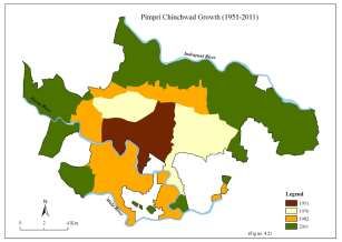
© 2020 JETIR October 2020, Volume 7, Issue 10                                                 www.jetir.org (ISSN-2349-5162)

         In 15-years period time the total 38 fringe villages counted within the PMC and 18 villages in the PCMC region and the
total urban area was nearly doubled i.e. 669.3 Km2. The process of fusion of villages in the fringe zone continues to extend the
metropolitan area to 669,3 Km2, in which Pune city has occupied 430 Km2, and PCMC has occupied 171.51 Km2. [15], [14]
         The growth of the population was so strong that the area expansion of PMR continues till the recent past. In 1981 the
population growth of PCMC was 178.82% which declined to 95.8% in 2001. This may be because of inclusion of 18 villages in
PCMC region. [15]

                                                       Fig. 1. Bar Chart
                                               (Source: PCMC Development Plan)

          2.1.1. Growth in Population within Municipal Corporation – A statistical perspective
         As per the 2011 India statistics, Pimpri-Chinchwad had a population of about 1,729,320. Talking about population, in
order to check out the population of Pimpri-Chinchwad in 2017, we need to have a look at the population of the past 5 years. They
are as per the following:
                  2012 –1.75 Million        2013 –1.78 Million         2014 –1.82 Million
                  2015 –1.84 Million        2016 – 1.86 Million
         Taking a look at the population of Pimpri-Chinchwad from the year 2012-16, it has been noticed that there has been an
increase of 1.1 Million in the past 5 years. Therefore, it has been seen that every year the population increases by 0.22 Million.
Hence, the population of Pimpri-Chinchwad in 2017 is forecasted to be 1.86 Million + 0.22 Million = 2.08 Million. So, the
population of Pimpri-Chinchwad in the year 2017 as per estimated data = 2.08 Million. (India Population 2017)

JETIR2010316           Journal of Emerging Technologies and Innovative Research (JETIR) www.jetir.org                       2445
© 2020 JETIR October 2020, Volume 7, Issue 10                                                     www.jetir.org (ISSN-2349-5162)

         The increase in population has given rise to its own set of challenges. It has led to the growth of urban sprawls. Sprawling
neighborhood residents continue to emit more emissions per person and experience more fatalities in traffic. Sprawl is problematic
with proponents saying Consumers prefer neighborhoods of lower density and that sprawl don't automatically raise in traffic. [17],
[14]
         As regards spatial development, by the end of the last millennium the municipality has expanded from about 64 square
kilometers to over 170 square kilometers.[15] Table 1, Fig. 2., Fig.3.
                                 The timeline for this growth has been captured in the table below

             Sr. no.           Year             Area (Km²)                               Spatial Growth
                                            Pimpri Chinchwad
                                                 Municipal
                1              1970          Corporation-“C”
                                           class city , formed on
                                                04-03-1970
                                                                            Pimpri Chinchwad New Town Development
                2              1972                64.65                   Authority was established to create a planned
                                                                              environment for the working population.
                                                                         Status change from “C” class to “A” class from 7th
                3              1975                64.65
                                                                                           January 1975
                                                                          Municipal corporation is formed. Seven villages
                4              1982                  86                  merged in the municipal council. PCMC is formed
                                                                                          on 05-10-1982
                                                                                   Addition of 18 new villages in
                5              1997               171.56
                                                                              PCMC area. Addition of 84.51 Km² area.

                                                           Table 1
                                 Spatial growth of Pimpri Chinchwad Municipal Corporation
                                               (Source: PCMC, CDP 2006-2012)

                    Fig. 2. The map below provides a different view on growth of the municipality over time

JETIR2010316           Journal of Emerging Technologies and Innovative Research (JETIR) www.jetir.org                         2446
© 2020 JETIR October 2020, Volume 7, Issue 10 www.jetir.org (ISSN-2349-5162)
Fig. 3. Fringe area development around PCMC boundary
(Pimpri Chinchwad New Development Authority-PCNTDA)
2.2. Growth Management and Land use
The town's development strategy is in the context of land-use planning. With the creation of the planning authority in 1982,
a Development Plan (DP) for the 86 sq kilometer PCMC area was drawn up. State approved on 18 September 1995. For impact
from 2 November 1995, the DP came into force. Within this old DP due for revision in 2007, 32 per cent of the region was built
against a proposed growth of around 74 per cent of the 86.01 sq.km. Today, however, a research survey reveals that the entire 86.01
sq.km area has been established but not in line with what was envisaged in the DP. [17]
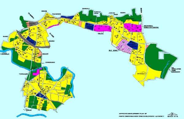
Fig. 4. The pie chart below gives a view on the land use distribution with the municipal corporation
(Source: PCMC - Land use distribution)
2.2.1. Executive Summary - Pimpri Chinchwad Municipal Corporation
Some areas which were under PCNTDA 's planning jurisdiction were integrated with PCMC in 1997. To these areas a new
DP has been installed. This is in the draft stage and cannot be approved yet. The primary urban planning issue in Pimpri-Chinchwad
is the time-consuming implementation of the DP, which has led to haphazard developments on the outskirts of the city. An
established growth pattern as envisaged in the development plan is required for an orderly development and transformation of the
city. [16]
JETIR2010316 Journal of Emerging Technologies and Innovative Research (JETIR) www.jetir.org 2447© 2020 JETIR October 2020, Volume 7, Issue 10 www.jetir.org (ISSN-2349-5162)
Below Table 2 presented a description of the land through the different areas which constitute the municipality.
Sr. No Land Area (Sq.km)
1 Old Municipal Area 32.97
2 Newly Added Area 80.88
3 M.I.D.C 12.32
4 P.C.N.T.D.A 32.57
PCNTDA Transfer To
5 11.82
PCMC
Total 170.56
Table 2
Distribution of Pimpri Chinchwad Municipal Corporation Area (2001)
(Source: PCMC, CDP 2006-2012)
The increase in population has over time changed the land usage, significantly increasing the built-up area, reducing water bodies,
vegetation, hills and barren land. Fig. 5
Fig. 5. The Map below shows how the land usage has changed over time.
(Source: PCMC Development Plan)
2.3. Urban Transport
As far as public transport services are concerned, Pimpri Chinchwad Municipal Transport (PCMT) is the sole provider of
the service and has been in operation from 1974. The public transport network in the PCMC area is one of the CDP's most significant
components and must be considered as an integral part of the Pune Metropolitan Region (PMR) consisting of Pune and Pimpri-
Chinchwad. [16]
With five million residents, PMR generates 3.5 million daily commuters. For this, PCMT only serves 22 percent for
commuters leaving the rest to use other modes of transportation such as three-wheelers and customized vehicles. PCMT's customer
base and operating performance have declined dramatically over the years due to a lack of sufficient network upgrades. [16], [7]
PCMC includes more than 3.4 lakh vehicles registered. Their number has risen over the last five years at a rate of over 13
per cent. The biggest effect of the large number of cars on the road is the danger to the health of pedestrians / kids and the elderly.
JETIR2010316 Journal of Emerging Technologies and Innovative Research (JETIR) www.jetir.org 2448© 2020 JETIR October 2020, Volume 7, Issue 10 www.jetir.org (ISSN-2349-5162)
Based on this infrastructure assessment, a demand-supply gap study was conducted to estimate the level of investment needed for
the city of Pimpri-Chinchwad. An infrastructure growth program had been chalked out accordingly. [7], Fig. 4
2.4. Roads and Street lighting
The role of PCMC in the city's road infrastructure involves the development and maintenance of all roads under its
jurisdiction, except for roads belonging to the Department of Public Works (highways and other district-level roads). Although it is
the developer 's duty to build internal roads in the case of a planned development, at the time of approval, PCMC verifies adequacy
with regard to the development plan. Once the layout is developed, PCMC will take over the roads and open up maintenance spaces.
[7] PCMC is also responsible for implementing the plans for the master plan involving new main roads and road widening activities.
The total length of the road in the town is 757 km, 89 percent of which are paved. This network spans the length and breadth of the
town’s-built city. Even the newer peripheral areas added to PCMC lack adequate coverage. Also, although the service reach is
reasonably situated, the state of the road surface was an area of concern due to the significant rise in the number of vehicles on the
city roads. This includes even the regional traffic that enters the city due to lack of bypass / ring roads. Consequently, traffic
congestion was encountered during peak hours at the main roads and intersections of late. [7]
A compulsory feature of PCMC is the installation and maintenance of streetlights. The PCMC 's electricity department is
responsible for building, replacing, restoring, running, and maintaining streetlights in the area. There are about 37,783 street-light
poles with various types of electrical fixtures in the city of Pimpri Chinchwad. High-power lamps, primarily sodium vapor lamps
of different wattages — 70W, 150W and 250W are 83 percent of the fixtures. Tube lights account for 16 percent of the fixtures.
Against the length of the road accessible 757 km. Within the limits of the PCMC, the maximum spacing of streetlight poles is
approximately 20 meters, which rates well against the norm of 30 meters. [7]
3. Results and Conclusion
Planning for the growth of the metropolitan area demands utmost priority in the sense of urban design, on par with the city
area. Since urban areas on the outskirts of the city are targeted by the cycle of urbanization, future population prediction, planning
for sustainable population density growth, planning for adequate infrastructure facilities, strengthening institutional structures,
monitoring and implementation of regulatory initiatives, preparation of built-in mid-course corrective measures and innovative
preparation for new areas outside the metropolitan area need to be emphasized.
A shared vision of the future growth of a city area is an important for successful urban reconstruction and development.
The Vision for the City of Pimpri-Chinchwad is conceived in an integrated and coherent way through continued consultation with
stakeholders. The meetings focused on the strengths of the community, current issues, complaints, challenges and areas of focus
for the future. Agricultural workers, especially women, are typically thrown out of agriculture because rural land is used for urban
purposes; they do not have the skills needed for alternative employment opportunities. There is an increase in construction male
worker numbers in urban fringe villages while it is discouraged to hire female helpers. Compensatory growth of urban linked
activities has occurred in which displaced labor force could be absorbed in agriculture. Self-help groups and NGOs may provide
valuable inputs here.
In this study, the primary surveys in the fringe areas show that, if land-use is methodically designed and performed, the
prospects tend to be good at achieving the visualized target (not just a pipe dream). The people in the driving seat will get suitable
initiative and constructive feedback from all quarters if they are sincere and articulate what they expect of the citizens of Pimpri
Chinchwad, Pune.
4. Perspective and Vision for the city
"Pimpri-Chinchwad is the place to live, make investments and have fun. It will help to maintain and sustain vigorous
economic growth in the region through a modern, systematized approach.
“ENRICHED ENVIRONMENT"
JETIR2010316 Journal of Emerging Technologies and Innovative Research (JETIR) www.jetir.org 2449© 2020 JETIR October 2020, Volume 7, Issue 10 www.jetir.org (ISSN-2349-5162)
5. Acknowledgements
The writers wish to thank the anonymous referees for their positive feedback and comments.
References:
[1] Birkhamshaw, A. J., & Whitehand, J. W. R. (2012). Conzenian urban morphology and the character areas of planners and
residents. URBAN DESIGN International, 17(1), 4–17. doi: 10.1057/udi.2011.22
[2] Chen, H.-C., Han, Q., & Vries, B. D. (2020). Urban morphology indicator analyzes for urban energy modeling. Sustainable
Cities and Society, 52, 101863. doi: 10.1016/j.scs.2019.101863
[3] Fernandez, R. B., & Dhorde, A. A. (n.d.). Assessment of spatio-temporal variations in land use land cover over pimpri
chinchwad Municipal corporation using Remote sensing data, 1-10, Volume 4, No 4, 2014. ISSN 0976 – 4380
[4] Gospodini, A. (2004). Urban morphology and place identity in European cities: built heritage and innovative design. Journal
of Urban Design, 9(2), 225–248. doi: 10.1080/1357480042000227834
[5] Hirtle A C and Frank A U (eds) 1997 Spatial Information Theory: A Theoretical Basis for GIS. Berlin, Springer-Verlag Lecture
Notes in Computer Science No 1329
[6] Holanda F (ed) 1999 Proceedings of the Second International Symposium on Space Syntax, Universidade de Brasilia, Brasilia,
29 March±2 April 1999. Brasilia, Fundacao de Apoio a Pesquisa do Distrito Federal
[7] Jawaharlal Nehru National Urban Renewal Mission PIMPRI-CHINCHWAD City
Development Plan 2006-2012.
[8] Jiang, B., & Claramunt, C. (2002). Integration of Space Syntax into GIS: New Perspectives for Urban
Morphology. Transactions in GIS, 6(3), 295–309. doi: 10.1111/1467-9671.00112
[9] Mesev, T. V., Longley, P. A., Batty, M., & Xie, Y. (1995). Morphology from Imagery: Detecting and Measuring the Density
of Urban Land Use. Environment and Planning A: Economy and Space, 27(5), 759-780. doi:10.1068/a270759
[10] Nagarale, V. (2018). Geographical assessment of urban utilities in Pune Municipal Corporation region with changing urban
population. RUDN Journal of Economics, 26(3), 506–519. doi: 10.22363/2313-2329-2018-26-3-506-519
[11] Pinho, P., & Oliveira, V. (2009). Cartographic analysis in urban morphology. Environment and Planning B: Planning and
Design, 36(1), 107–127. doi: 10.1068/b34035
[12] zope, R. p. (n.d.). The planning strategies for urban land use pattern: A case study of Pune city, india. Vol. 2, Issue 7, July
2013 ISSN: 2319-8753
[13] Urban Structure and Morphology, Estelar, Chapter-V (Ref P.No.159 & 160)
[14] Chapter II - Study Area of Pune Municipal Corporation and Pimpri Chinchwad Municipal Corporation
[15] Chapter IV- Impact on Land. (Ref: P. No. 49,56,57,60,67)
[16] Pimpri-Chinchwad Municipal Corporation (PCMC) Comprehensive Mobility Plan (CMP) for PCMC
[17] Pimpri-Chinchwad Municipal Corporation Development Plan -2021 for newly merged area in Pimpri- Chinchwad Municipal
Corporation Draft Development Plan.
JETIR2010316 Journal of Emerging Technologies and Innovative Research (JETIR) www.jetir.org 2450You can also read