2019 ASSESSMENT METHODOLOGY - AGRICULTURAL, DEVELOPMENT AND OTHER LAND - City of Edmonton
←
→
Page content transcription
If your browser does not render page correctly, please read the page content below
2019
ASSESSMENT
METHODOLOGY
AGRICULTURAL, DEVELOPMENT
AND OTHER LAND

A summary of the methods used by the City of Edmonton in
determining the value of agricultural, development and dual use
land properties in Edmonton for assessment purposes.

edmonton.ca/assessment

Revised: February 21, 2019 (see revision history)
2019 Agricultural, Development, Urban Service, and Other Land
Assessment Methodology Page | 1
Table of Contents
Table of Contents 1
Scope 2
Introduction 2
Mass Appraisal 4
Valuation Models 6
Approaches to Value 7
Direct Sales Approach 7
Property Groups 8
Agricultural and Farm Land 8
Development Land 11
Urban Service and Other Land 13
Zoning 14
Agricultural Use Zoning 15
Classification of Agricultural and Development Lands 16
Land Use (LUC) 16
Farm Buildings 17
Definitions 17
Methods to Adjust Comparables 18
Quantitative Adjustments 18
Qualitative Analysis 19
Revision History 19
References 20
Appendix 21
Map 21
Sample Assessment Detail Reports 22
Zone Charts for Agriculture, Development, Urban Service and Other Land 23
Measure Conversion Chart 30
2019 Agricultural, Development, Urban Service, and Other Land
Assessment Methodology Page | 2
Scope
This guide is an aid in explaining how Agricultural, Development, Urban Service, and Other Land
properties are valued for assessment purposes. It sets out the valuation method and procedure to
derive market values. The information presented in this guide is aimed at deriving values for a group of
properties with similar property characteristics. In some circumstances, not every property’s valuation
parameters will be covered.
The guide is intended as a tool; it is not intended to replace the assessor’s judgment in the valuation
process.
This icon signifies when legislation is quoted.
Introduction
Property assessments in the City of Edmonton are prepared in accordance with the requirements of the
Matters Relating to Assessment and Taxation Regulation, 2018, Alta Reg 203/2017, (hereinafter
“MRAT” ). This regulation establishes the valuation standard to be used, defines the procedures to be
applied, and proposes objectives for the quality to be achieved in the preparation of assessments. The
legislation requires the municipality to prepare assessments that represent market value by application
of the mass appraisal process. All assessments are expected to meet quality standards prescribed by the
province in the regulation.
Property assessments represent:
● an estimate of the value
● of the fee simple estate in the property
● as it existed on December 31, 2018
● would have realized if it had been sold on July 1, 2018
● on the open market and under typical market conditions
● from a willing seller to a willing buyer
The assessment is a prediction of the value that would result when those specific, defined conditions are
met.2019 Agricultural, Development, Urban Service, and Other Land Assessment Methodology Page | 3 Both market value and property, along with additional terms are defined in the Municipal Government Act, RSA 2000, c M-26 (hereinafter the “MGA” ) and MRAT :
2019 Agricultural, Development, Urban Service, and Other Land
Assessment Methodology Page | 4
Mass Appraisal
Mass appraisal is the legislated methodology used by the City of Edmonton for valuing individual
properties, and involves the following process:
● properties are stratified into groups of comparable property
● common property characteristics are identified for the properties in each group
● a uniform valuation model is created for each property group
The following two quotations indicate how the International Association of Assessing Officers
distinguishes between mass appraisal and single-property appraisal:2019 Agricultural, Development, Urban Service, and Other Land
Assessment Methodology Page | 5
For both mass appraisal and single-property appraisal, the process consists of the following stages:
Mass Appraisal Single Appraisal
Mass appraisal is used to The client specifies the nature of the
determine the assessment value to be estimated, including rights
Definition and Purpose base for property taxation in to be valued, effective date of
accordance with legislative valuation, and any limiting conditions
requirements
Mass appraisal requires a The extent of data collection is
continuing program to specific to each assignment and
Data Collection maintain a current database of depends on the nature of the client’s
property characteristics and requirements
market information.
Mass appraisal is predicated Market analysis includes the analysis
Market Analysis
on highest and best use of highest and best use
Valuation procedures are Subject property is the focus of the
Valuation Model predicated on groups of valuation. The analysis of comparable
comparable properties properties is generally six or less
The testing of acceptable The reliability of the value estimate is
analysis and objective criteria more subjective. Acceptability can be
Validation judged by the depth of research and
analysis of comparable sales2019 Agricultural, Development, Urban Service, and Other Land
Assessment Methodology Page | 6
Valuation Models
A valuation model creates an equation of variables, factors and coefficients that explains the
relationship between estimated market value and property characteristics.
● variables are created from property characteristics
● analysis of how variables affect market value
Valuation Model
● factors and coefficients are determined
● the resulting valuation models are applied to property characteristics
Depending on the property type multiple regression analysis or other mass appraisal techniques are
used to determine variables, factors and coefficients.
An assessed value is calculated by applying the appropriate valuation model to individual properties
within a group.2019 Agricultural, Development, Urban Service, and Other Land
Assessment Methodology Page | 7
Approaches to Value
The most common approaches to determine market value are the direct sales, income, and cost. Each
emphasizes a particular kind of market evidence.
Typical market value (or some other characteristic) is determined by
Direct Sales referencing comparable sales and other market data. It is often used when
Approach sufficient sales or market data is available. It may also be referred to as the
Sales Comparison Approach.
This approach considers the typical actions of renters, buyers and sellers
when purchasing income-producing properties. This approach estimates the
Income Approach
typical market value of a property by determining the present value of the
projected income stream. Often used to value rental or leased property.
Typical market value is calculated by adding the depreciated replacement
cost of the improvements to the estimated value of land. It is often used for
Cost Approach
properties under construction or when there is limited market data
available.
Direct Sales Approach
The direct sales approach is the most appropriate method of valuation for Agriculture, Development,
Urban Service, and Other Land properties in the City of Edmonton because it mirrors the actions of
buyers and sellers in the marketplace and sufficient sales data exists in order to derive reliable market
estimates.
The cost approach to value was applied to improvements on Agriculture, Development, Urban Service,
and Other Land properties. Improvements on these groups of land properties were valued using the
Marshall and Swift Costing Manual for buildings with farm usage, and the City of Edmonton Residential
Module Manual for buildings with residential usage. The income approach was not used in the valuation
of these properties, since that approach is more applicable to income producing properties.
The City of Edmonton validates all land title transactions (sales). The validation process can include site
inspections, interviews with parties involved, a review of land title documents, corporate searches, third
party information, and sale validation questionnaires. Sales analysis for Agriculture, Development,
Urban Service, and Other Land also includes a review for future zoning changes, current and proposed
area structure plans, availability of services and/or cost of providing services, and development
applications.
The City of Edmonton reviews sales occurring from July 1, 2013 to June 30, 2018 for valuation of
Agriculture, Development, Urban Service, and Other Land property. The City of Edmonton uses the date
the legal title transfer was registered at the Land Titles Office as the sale date of a property.2019 Agricultural, Development, Urban Service, and Other Land
Assessment Methodology Page | 8
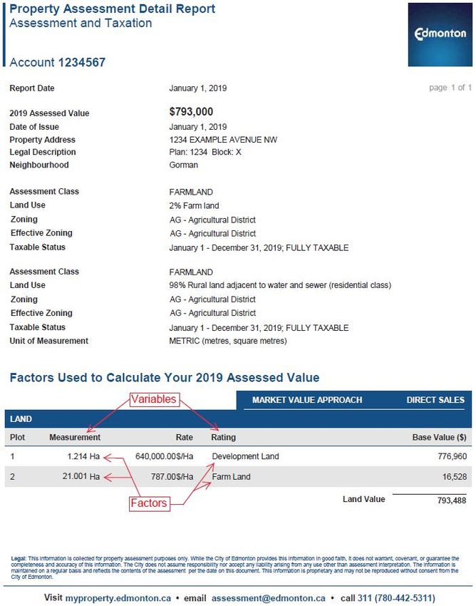
Sale price reflects the condition of a property on the sale date and may not be equal to the
assessment.
Property Groups
The use of a property determines the property groupings and the valuation model applied.
Agricultural and Farm Land
Agricultural land includes land where all or part of the property is used for farming operations, as
defined in Section 2(1)(f) of MRAT as:
…the raising, production and sale of agricultural products and includes:
(i) horticulture, aviculture, apiculture and aquaculture,
(ii) the raising, production and sale of
(a) horses, cattle, bison, sheep, swine, goats or other livestock,
(b) fur-bearing animals raised in captivity,
(c) domestic cervids within the meaning of the Domestic Cervid Industry Regulation
(AR 188/2014), or
(d) domestic camelids,
(iii) the planting, growing and sale of sod;
(iv) an operation on a parcel of land for which a woodland management plan has been approved
by the Woodlot Association of Alberta or a forester registered under Regulated Forestry
Profession Act for the production of timber primarily marketed as whole logs, seed cones or
Christmas trees,
but does not include any operation or activity on land that has been stripped for the purposes
of, or in a manner that leaves the land more suitable for, future development;
Following the procedures set out in the Alberta Farmland Assessment Minister’s Guidelines, Agricultural
Land in the City of Edmonton that meets the definition of farm land, has been assessed for 2018 at the
rate of $787 per Hectare or $318 per acre.
Section 7(3) of MRAT requires that the following property be assessed at market value notwithstanding
that all or part of the property is used for farming operations:
• a parcel of land containing less than one acre;2019 Agricultural, Development, Urban Service, and Other Land
Assessment Methodology Page | 9
• a parcel of land containing at least one acre but not more than 3 acres that is used but not
necessarily occupied for residential purposes or can be serviced by using water and sewer
distribution lines located in land that is adjacent to the parcel;
• an area of 3 acres located within a larger parcel of land where any part of the larger parcel is
used but not necessarily occupied for residential purposes;
• an area of 3 acres that is located within a parcel of land, and can be serviced by using water
and sewer distribution lines located in land that is adjacent to the parcel;
• any area that is located within a parcel of land, is used for commercial or industrial purposes,
and cannot be serviced by using water and sewer distribution lines located in land that is
adjacent to the parcel;
• an area of 3 acres or more that is located within a parcel of land, is used for commercial or
industrial purposes, and can be serviced by using water and sewer distribution lines located in
land that is adjacent to the parcel.
Pursuant to s. 2(1)(f) of MRAT, any lands that are “stripped for the purposes of, or in a manner that
leaves the land more suitable for, future development” do not qualify as a “farming operation” and
therefore are assessed at market value.
In accordance with previous decisions of the Composite Assessment Review Board, land on which
agricultural activity occurs may not constitute “farm land” in certain circumstances where:
• the agricultural use is unlawful pursuant to zoning restrictions and the absence of
development approval, and the landowner has no valid claim to a legal non-conforming use; or
• the farming or agricultural activity is not a bona fide farming operation, but occurs solely or
primarily to obtain a tax benefit.
In these circumstances, the land will be assessed at market value.
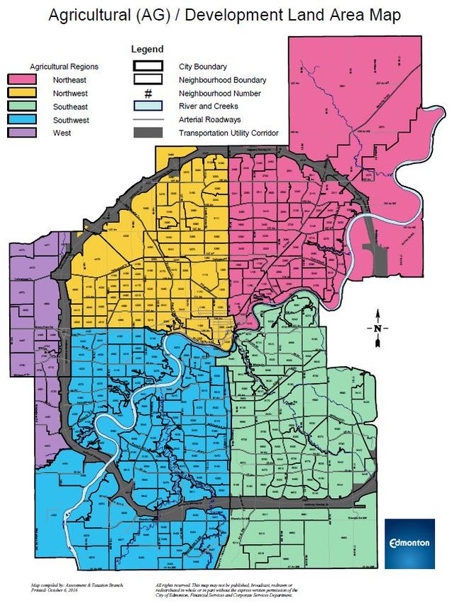
Agricultural Lands are categorized into the below ratings. All of the agricultural land rates are affected by
the region of the City in which a property is located, with the exception of the FARM rate. See the
Agricultural (AG) / Development Land Area Map to view the Agricultural Regions.
Agricultural Land Rates
Rates Description Rates Description
16 1st acre 21 Premium Location 3rd acre
17 2nd acre 22 Urban Influence 1st acre
18 3rd acre 23 Urban Influence 2nd acre
19 Premium Location 1st acre 24 Urban Influence 3rd acre
20 Premium Location 2nd acre FARM Farm Land2019 Agricultural, Development, Urban Service, and Other Land Assessment Methodology Page | 10 Rural Res 1st Acre (16): Rural Res 1st Acre refers to the first acre of a 3 acre site on Agricultural Land that is used but not necessarily occupied for residential purposes and is not part of a rural residential neighbourhood. Rural Res 2nd Acre (17): Rural Res 2nd Acre refers to the second acre of a 3 acre site, on Agricultural Land that is used but not necessarily occupied for residential purposes and is not part of a rural residential neighbourhood. Rural Res 3rd Acre (18): Rural Res 3rd Acre refers to the third acre of a 3 acre site, on Agricultural Land that is used but not necessarily occupied for residential purposes and is not part of a rural residential neighbourhood. Rural Res Acreage 1st Acre Premium Location (19): Rural Res Acreage 1st Acre Premium Location refers to t he first acre of a 3 acre site on Agricultural Land that is used but not necessarily occupied for residential purposes, is not part of a rural residential neighbourhood, and is considered a Premium Location. Premium Location refers to properties that abut or are across the road from a green space, natural reserve, lake, pond, ravine, river, or golf course. Rural Res Acreage 2nd Acre Premium Location (20): Rural Res Acreage 2nd Acre Premium Location refers to the second acre of a 3 acre site, on Agricultural Land that is used but not necessarily occupied for residential purposes, is not part of a subdivision, and is considered a Premium Location. Premium Location refers to properties that abut or are across the road from a green space, natural reserve, lake, pond, ravine, river or golf course. Rural Res Acreage 3rd Acre Premium Location (21): Rural Res Acreage 3rd Acre Premium Location refers to the third acre of a 3 acre site, on Agricultural Land that is used but not necessarily occupied for residential purposes, is not part of a rural residential neighbourhood, and is considered a Premium Location. Premium Location refers to properties that abut or are across the road from a green space, natural reserve, lake, pond, ravine, river or golf course. Rural Res Proximity to Urban Influence 1st Acre (22): Rural Res Proximity to Urban Influence 1st Acre refers to the first acre of a 3 acre site on Agricultural Land that is used but not necessarily occupied for residential purposes and is abutting or across the road from development as defined in section 616(b) of the MGA or can be serviced by using water and sewer distribution lines located in land that is adjacent to the parcel. Rural Res Proximity to Urban Influence 2nd Acre (23): Rural Res Proximity to Urban Influence 2nd Acre refers to the second acre of a 3 acre site, on Agricultural Land that is used but not necessarily occupied for residential purposes and is abutting or across the road from development as defined in section 616(b) of the MGA or can be serviced by using water and sewer distribution lines located in land that is adjacent to the parcel. Rural Res Proximity to Urban Influence 3rd Acre (24): Rural Res Proximity to Urban Influence 3rd Acre refers to the third acre of a 3 acre site, on Agricultural Land that is used but not necessarily occupied for residential purposes and is abutting or across the road from development as defined in section 616(b) of the MGA or can be serviced by using water and sewer distribution lines located in land that is adjacent to the parcel.
2019 Agricultural, Development, Urban Service, and Other Land
Assessment Methodology Page | 11
Farmland (FARM): Agricultural land includes land where all or part of the property is used for farming
operations, defined in Section 2(1)(f) of MRAT. Farm rates are prescribed by the Province of Alberta and
is a standard value within the City of Edmonton.
Development Land
Development Land is land that is undergoing, or is anticipated to undergo, development activity. This
may relate to all or part of the property. Pursuant to s. 616(b) of the Municipal Government Act,
development means:
(i) an excavation or stockpile and the creation of either of them,
(ii) a building or an addition to or replacement or repair of a building and the construction or
placing of any of them on, in, over or under land,
(iii) a change of use of land or a building or an act done in relation to land or a building that
results in or is likely to result in a change in the use of the land or building, or
(iv) a change in the intensity of use of land or a building or an act done in relation to land or a
building that results in or is likely to result in a change in the intensity of use of the land or
building
Development rates will have different market values depending on the region of the City in which the
property is located. See the Agricultural (AG) / Development Land Area Map to view the Agricultural
Regions. The estimation of how close a parcel is to development is based upon what steps have been
taken in the development process as of December 31 of the prior year. Area Structure Plans, proximity
to servicing, development applications, and inspections all help to determine which phase of
development the parcel is in. To reflect diminishing returns, development land is assessed at a lower
rate every ten hectares. For fairness and equity, the actual time to develop as planned by the property
owner or developer is not taken into consideration.
Development Land Rates
Rates Description Rates Description Rates Description
1 Development 6 Premium 25 Non Residential
Development Premium Non Residential
3 8 27
2 to 3 years 2 to 3 years 2 to 3 years
Development Premium Non Residential
4 9 28
4 to 5 years 4 to 5 years 4 to 5 years
Development Premium Non Residential
5 10 29
> 5 years > 5 years > 5 years2019 Agricultural, Development, Urban Service, and Other Land Assessment Methodology Page | 12 Development Land (1): Development Land is Residential Development Land, which is ready to be developed and is typically forecasted to be subdivided into smaller parcels within a year. Development Land Phase 2 to 3 years (3): Development Land Phase 2 to 3 years is Residential Development Land, which is ready to be developed and is typically forecasted to be subdivided into smaller parcels within 2 to 3 years. Development Land Phase 4 to 5 years (4): Development Land Phase 4 to 5 years refers to Residential Development Land, which is ready to be developed, and is typically forecasted to be subdivided into smaller parcels within 4 to 5 years. Development Land Phase More Than 5 years (5): Development Land Phase More Than 5 years refers to Residential Development Land which is ready to be developed and is typically forecasted to be subdivided into smaller parcels in more than 5 years. Development Land with Premium Location (6): Development Land is Residential Land, which is ready to be developed and is typically forecasted to be subdivided into smaller parcels within a year. Premium Location refers to properties that abut or are across the road from green space, natural reserve, lake, pond, ravine, river or golf course. Development Land with Premium Location Phase 2 to 3 years (8): Development Land Phase 2 to 3 years is Residential Development Land, which is ready to be developed and is typically forecasted to be subdivided into smaller parcels within 2 to 3 years. Premium Location refers to properties that abut or are across the road from green space, natural reserve, lake, pond, ravine, river or golf course. Development Land with Premium Location Phase 4 to 5 years (9): Development Land Phase 4 to 5 years refers to Residential Development Land, which is ready to be developed, and is typically forecasted to be subdivided into smaller parcels within 4 to 5 years. Premium Location refers to properties that abut or are across the road from green space, natural reserve, lake, pond, ravine, river or golf course. Development Land with Premium Location Phase Plus 5 years (10): Development Land Phase More Than 5 years refers to Residential Development Land which is ready to be developed and is typically forecasted to be subdivided into smaller parcels in more than 5 years. Premium Location refers to properties that abut or are across the road from green space, natural reserve, lake, pond, ravine, river or golf course. Non-Residential Development Market (25): Non-Residential Development Market refers to Non-Residential Development Land that is typically forecasted to be subdivided into smaller parcels within a year. Non-Residential Development Phase 2 to 3 years (27): Non-Residential Development Phase 2 to 3 years refers to Non-Residential Development Land that is typically forecasted to be subdivided into smaller parcels within two to three years.
2019 Agricultural, Development, Urban Service, and Other Land
Assessment Methodology Page | 13
Non-Residential Development Phase 4 to 5 years (28): Non-Residential Development Phase 4 to 5 years
refers to Non-Residential Development Land that is typically forecasted to be subdivided into smaller
parcels within 4 to 5 years.
Non-Residential Development Phase Plus 5 years (29): Non-Residential Development Phase Plus 5 years
refers to Non-Residential Development Land that is typically forecasted to be subdivided into smaller
parcels within 5 years or more.
Urban Service and Other Land
Assessment of Public Utility, Urban Service and Park Land
Rates Description Rates Description
AP AP, A (Park Land) PU Public Utility Lot
NP Natural Preserve US Urban Service Lot 1st 2 hectares (ha)
30 Raw Land
US Unserviced Urban Service Lot (Unserviced)
US Excess Urban Service Lot (excess)
A, AP Park Land (AP): Park Land refers to all or part of a property that is zoned or permitted to be used
as Metropolitan Recreation Zone or Public Parks Zone as per City Zoning Bylaw 12800. If the current
permitted use is different from the actual zoning of A/AP, then the appropriate market value rate would
apply.
Natural Preserve Land (NP): Similar to Parkland, Natural Preserve Land refers to areas with uses
severely limited by topographical, and legal permissible use. This rate is most often used in the
assessment of NA zoned land and properties located in the River Valley, which are frequently limited by
the slope of the embankment as well as the North Saskatchewan River Valley and Ravine System
Protection Overlay in the Zoning Bylaw.
Public Utility Lot (PU): A Public Utility Lot refers to all or part of a property that is zoned or permitted to
be used as Public Utility Zone as per City Zoning Bylaw 12800. A Public Utility Lot also refers to a
property that provides or is intended to provide a system or works for public consumption, benefit,
convenience or use that is not zoned PU but may be subject to a restrictive covenant, easement or
otherwise identified for public benefit (i.e. by Area Structure Plan).
Raw Land (30): This rate is applied to all or part of a property that is vacant land and does not meet the
definition of “farming operations” in Section 1(i) of MRAT. I t is not serviced or prepared for
development, or in close proximity to existing development. Such parcels are typically more than 5 years
from development. This market rate will vary depending on the region of the City that the property is
located in. See Agricultural and Development Land Area Map.2019 Agricultural, Development, Urban Service, and Other Land Assessment Methodology Page | 14 Urban Service Lot (US): A serviced Urban Service Lot refers to all or part of a property that is zoned or permitted to be used as Urban Service under City Zoning Bylaw 12800. Urban Service Lot (US) refers to an area up to the first two hectares of a serviced parcel of vacant land and/or the area of improved site coverage. The balance of the land is assessed at the US EXCESS rate. Urban Service Lot (US Excess): An Urban Service Lot (US Excess) is a portion of the property that refers to all or part of a property that is zoned or permitted to be used as Urban Service under City Zoning Bylaw 12800, and that exceeds 2 hectares. Urban Service Lot (US Unserviced): An Urban Service Lot (US Unserviced) refers to all or part of a property that is zoned or permitted to be used as Urban Service under City Zoning Bylaw 12800. Urban Service Lot (US Unserviced) refers to an area up to the first two hectares of an unserviced parcel of vacant land and/or the area of improved site coverage. The balance of the land is assessed at the US Excess rate. Zoning The rules and regulations for land development within Edmonton are contained in the Zoning Bylaw, No. 12800. A land zone summary is in the appendix. Effective zoning is an internal coding applied to reflect the current use and/or development potential of a parcel. Effective zoning will generally reflect the actual zoning of a parcel, but may differ on properties with a legal non-conforming use, Direct Control zoning or in other limited circumstances. In cases where a legal non-conforming use is discontinued for six (6) or more months, any future use must conform to the Zoning Bylaw.
2019 Agricultural, Development, Urban Service, and Other Land Assessment Methodology Page | 15 Agricultural Use Zoning In determining whether a particular agricultural use is allowed under the applicable zoning, the type of agricultural use must be characterized. The three most common agricultural uses in the City of Edmonton are Rural Farms, Recreational Acreage Farms and Urban Outdoor Farms. These use classes may impact the classification of land when it is determined that an agricultural use is non-compliant with the zoning, and the landowner does not have a right to a legal non-conforming use.
2019 Agricultural, Development, Urban Service, and Other Land
Assessment Methodology Page | 16
Classification of Agricultural and Development Lands
As per MGA Section 297(1): When preparing an assessment of property, the assessor must assign one or
more of the following assessment classes to the property:
(a) class 1 - residential;
(b) class 2 - non-residential;
(c) class 3 - farmland;
(d) class 4 machinery and equipment.
Assigning assessment classes requires a consideration of the class definitions found within MGA section
297, MRAT, City of Edmonton Charter, Edmonton Zoning Bylaw, No. 12800, and possibly the Municipal
Development Plan, Area Structure Plans, and Overlays. Any legislation that affects how a property can
be used will affect its classification.
The Municipal Development Plan, Area Structure Plans, and Overlays can be found on the City website,
www.edmonton.ca, under “City Government > Bylaws > Zoning Bylaw” or “City Government > Urban
Planning & Design > Planning > Plans in Effect”.
Land Use (LUC)
Agricultural, Development, Urban Service and Other Land may have one or more of the following Land
uses (LUCs) based upon a property’s actual use. Land use (LUC) is an internal coding used to categorize
the current use of a property. The LUC may affect the assessed value of a property, and indicates which
corresponding tax (mill) rate will be applied.
LUC Description Assessment Class
272 Commercial greenhouse Non-Residential
258 Fenced storage Non-Residential
557 Road right of way Non-Residential
748 Undeveloped park Non-Residential
758 Natural preserve Non-Residential
760 Storm water pond Non-Residential
800 Acreage for residential use (building and land) Residential
805 Vacant/unimproved rural land Residential
822 Acreage for non-residential use (building and land) Non-Residential
832 Farm-use buildings and structures Farm Land
835 Residential development land Residential
853 Farm land Farm Land
855 Rural land adjacent to water and sewer (residential class) Farm Land
900 Undeveloped non-residential land Non-Residential
901 Utility lot for residential use Residential
902 Remnant or utility lot for non-residential use Non-Residential
950 Leased City-owned residential land Residential2019 Agricultural, Development, Urban Service, and Other Land
Assessment Methodology Page | 17
This list contains frequently used codes within the Agriculture, Development, Urban Service and Other
Land inventory of properties; it is not a complete list of all Land uses applied by The City of Edmonton.
Farm Buildings
Farm buildings are buildings used for farming operations. They include barns, riding stables and arenas,
shops, machinery storage buildings, hay sheds, calving barns, farm utility buildings, greenhouse
buildings, quonsets and steel grain bins. Farm buildings do not include any building, or a portion of a
building that is used for residential living accomodation, industrial, commercial, retail enterprise, or
other non farming use.
In assessing farm buildings, Section 298(l)(y) of the MGA states the following:
298 (1) No assessment is to be prepared for the following property:
(y) farm buildings, except to the extent prescribed in the regulations
Section 8 of MRAT q ualifies this by indicating that:
(2) For the purposes of section 298(1)(y) of the Act, an assessment must be prepared for any
farm building located in a city, town, village or summer village.
(3) In preparing an assessment for a farm building, the assessor must determine its value based
on its use for farming operations.
A farm building may qualify for a partial tax exemption pursuant to ss. 9 of MRAT:
30 (f) any farm building in a city, town, village or summer village, to the extent of
(i) 60% of its assessment for the 2018 taxation year,
(ii) 70% of its assessment for the 2019 taxation year,
(iii) 80% of its assessment for the 2020 taxation year,
(iv) 90% of its assessment for the 2021 taxation year, and
(v) 100% of its assessment for the 2022 taxation year and all subsequent taxation years.
In accordance with these regulations, assessments for farm buildings were prepared using the Cost
Approach. Costs were determined using the Marshall and Swift Cost Manual.
Definitions
Area Structure Plan: Area Structure Plan provides a framework for subsequent subdivision and
development of an area of land and includes things such as the sequence of proposed development
(MGA Section 633).
Bona Fide: Made in good faith without fraud or deceit; made with earnest intent.
Development applications: Development applications include subdivision, rezoning and road closure
applications, and applications to create or amend an Area Structure Plan.
Lot size: The area of a specific parcel determined through Geographic Information System and Alberta
Land Titles. It is measured in either imperial or metric.2019 Agricultural, Development, Urban Service, and Other Land
Assessment Methodology Page | 18
Overlay: An Overlay is an additional development regulation superimposed on specific areas of the City,
which supersedes or adds to the development regulations of the underlying zone. Refer to Zoning Bylaw
12800.
Servicing: The level of services available to a property. A property is fully serviced if it is or can be
serviced by using services located in an adjacent property. Services include storm sewer, sanitary sewer
and water service.
Methods to Adjust Comparables
There are two techniques for adjusting comparables: quantitative and qualitative.
Quantitative Adjustments
Each characteristic of a property can be measured or quantified by a mathematical expression
and adjusted for.
Several techniques are available to quantify adjustments to the sale prices of
comparable properties: data analysis techniques (including paired data
analysis, grouped data analysis, and secondary data analysis, statistical
analysis, graphic analysis… ( AIC, 2010, p. 14.2).
In the direct comparison approach, the best comparables are those sales that
require the least absolute a
djustment. ( AIC, 1995, p. 245).
Quantitative adjustments involve adjusting a known value (sale price for example) by adding or
subtracting an amount that a given characteristic adds to or subtracts from that value. A
quantitative adjustment should be made for each characteristic that differs between the
subject property and the comparable property.
Due to the legislative requirement to use mass appraisal, the City has used statistical analysis to
determine annual assessments.
“coefficient” means a number that represents the quantified relationship of each variable
to the assessed value of a property when derived through a mass appraisal process.
MRAT s.31(a)
The City is not required to disclose the coefficients. In the absence of quantitative adjustments,
an alternative technique is qualitative analysis.2019 Agricultural, Development, Urban Service, and Other Land
Assessment Methodology Page | 19
Qualitative Analysis
Each comparable property is compared with the subject property on an overall basis. In a
qualitative analysis, comparable properties are identified as inferior, similar, or superior overall
to the subject property in order to bracket the probable value range of the subject property.
When a sale property is considered to offer important market evidence but
finding the means to make quantitative adjustments is lacking, the appraiser
may turn to other major direct comparison techniques, q ualitative analysis.
(AIC, 2005, p. 19.10).
In reconciling value indications in the direct comparison approach, the appraiser
evaluates the number and magnitude of adjustments and the importance of the
individual elements of comparison in the market to judge the relative weight a particular
comparable sale should have in the comparative analysis. ( AIC, 2010, p. 13.16 ).
Qualitative analysis recognizes … the difficulty in expressing adjustments
with mathematical precision. ( AIC, 2010, p. 14.6 ).
…reliable results can usually be obtained by bracketing the subject between
comparables that are superior and inferior to it. ( AIC, 2010, p. 14.7).
If one or two comparable properties require fewer total adjustments than the
other comparables, an appraiser may attribute greater accuracy and give
more weight to the value indications obtained from these comparables,
particularly if the magnitude of the adjustments is approximately the same.
(AIC, 2010, p. 13.16).
Revision History
February 21, 2019 - removed Provincial Quality Standards section2019 Agricultural, Development, Urban Service, and Other Land
Assessment Methodology Page | 20
References
City of Edmonton. (2017). Zoning Bylaw No. 12800. Retrieved from City of Edmonton:
http://webdocs.edmonton.ca/InfraPlan/zoningbylaw/bylaw_12800.htm
Eckert, J., Gloudemans, R., & Almy, R. (1990). Property Appraisal and Assessment Administration.
Chicago, Illinois: International Association of Assessing Officers.
Farlex. (2015). Retrieved from The Free Dictionary: www.thefreedictionary.com
International Association of Assessing Officers [IAAO]. (1997). Glossary for Property Appraisal and
Assessment. Chicago IL.
Province of Alberta. (2018). Matters Relating to Assessment and Taxation Regulation. Retrieved from
Service Alberta, Queen's Printer: http://www.qp.alberta.ca
Province of Alberta. (2018). Municipal Government Act. Edmonton, AB: Queen's Printer.2019 Agricultural, Development, Urban Service, and Other Land Assessment Methodology Page | 21 Appendix Map
2019 Agricultural, Development, Urban Service, and Other Land Assessment Methodology Page | 22 Sample Assessment Detail Reports
2019 Agricultural, Development, Urban Service, and Other Land
Assessment Methodology Page | 23
Zone Charts for Agriculture, Development, Urban Service and Other Land
Agriculture and Reserve Zones
AG Agricultural Zone (s.610) is to conserve agricultural and rural land use activities
Urban Reserve Zone (s.620) is to allow for agricultural and rural land use activities and
AGU a limited range of other uses, that do not prejudice the future use of these lands for
urban use
Industrial Reserve Zone (s.630) is to allow for agricultural and rural land use activities
AGI
that do not prejudice future use when the lands are required for industrial use
Urban Services
Urban Services Zone (s.510) provides for publicly and privately owned facilities of an
US
institutional or community service nature
Public Utility Zone (s.520) is to provide for a system or works that is used to provide
for public consumption, benefit, convenience or use such as water or steam, sewage
PU
disposal, public transportation, irrigation, drainage, fuel, electric power, heat, waste
management and telecommunications.
Public Parks Zone (s.530) is to provide an area of public land for active and passive
AP
recreational uses, and allow for an opportunity for public schools
Natural Areas Protection Zone (s.531) is to conserve, preserve and restore identified
NA
natural areas, features and ecological processes.
Metropolitan Recreational Zone (s.540) is to preserve natural areas and parkland
A along the river, creeks, ravines and other designated areas for active and passive
recreational uses and environment protection
River Valley Activity Node (s.541) is to allow for limited commercial development
AN within activity nodes in designated areas of parkland along the river, creeks and
ravines
MA1 Municipal Airport Zone (s.550)
MA2 Municipal Airport Airfield Zone (s.551)
MA3 Municipal Airport General Business Zone (s.553)
AJ Alternative Jurisdiction Zone (s.560)2019 Agricultural, Development, Urban Service, and Other Land
Assessment Methodology Page | 24
For low to medium density housing on lands now surplus to public education needs
CS1 Community Services 1 Zone (s.570) is to provide for publicly and privately owned
facilities of an institutional or community service nature
CS2 Community Services 2 Zone (s.571) is to provide an area of public land for active and
passive recreation uses
CS3 Community Services 3 Zone (s.572) is to allow for agricultural and rural land use
activities and a limited range of other uses, that do not prejudice the future use of
these lands for urban use
CS4 Community Services 4 Zone (s.573) is to conserve agricultural and rural land use
Urban Institutional Zone (s.574) is to provide for facilities of an educational or
UI institutional nature, within mature areas of the city that could include additional uses
that would complement the institutional development.
Residential
Single Detached Residential Zone (s.110) is to provide for single detached housing
RF1
while allowing other forms of small scale housing
Residential Small Lot Zone (s.115) is to provide for smaller lot single detached housing
RSL
with attached garages
Low Density Infill Zone (s.120) is to retain single detached housing, while allowing
RF2
infill on narrow lots, uses include duplex housing
Planned Lot Residential Zone (s.130) is to provide for small lot single detached
RPL
housing, serviced by both a public roadway and a lane
Small Scale Infill Development Zone (s.140) is to provide for single detached housing
RF3 and semi-detached housing while allowing small-scale conversion and infill
redevelopment to buildings containing up to four dwellings
Semi-Detached Residential Zone (s.150) is to provide a zone primarily for
RF4
Semi-detached Housing and Duplex Housing
Residential Mixed Dwelling Zone (s.155) is to provide for a range of dwelling types
RMD
and densities including single detached, semi-detached and row housing
Row Housing Zone (s.160) s to provide for relatively low to medium density housing,
RF5
generally referred to as Row Housing2019 Agricultural, Development, Urban Service, and Other Land
Assessment Methodology Page | 25
Urban Character Row Housing Zone (s.165) is to provide for medium density Row
UCRH Housing in a manner that is characteristic of urban settings and can include more
intensive development
Medium Density Multiple Family Zone (s.170) is to provide for medium density
RF6
housing, where some units may not be at Grade
Residential
RA7 Low Rise Apartment Zone (s.210) provides for low rise apartment buildings
RA8 Medium Rise Apartment Zone (s.220) provides for medium rise apartment buildings
RA9 High Rise Apartment Zone (s.230) provides for high rise apartment buildings
Rural Residential Zone (s.240) is to provide for single detached residential
RR development of a permanent nature in a rural setting, generally without the provision
of the full range of urban utility services
Mobile Home Zone (s.250) is to provide for Mobile Homes developed within a Mobile
RMU
Home Park or Mobile Home Subdivision.2019 Agricultural, Development, Urban Service, and Other Land
Assessment Methodology Page | 26
The following areas have unique zoning requirements in the Special Areas section of the Zoning Bylaw
12800:
● 910 Special Area Downtown
● 920 Special Area Terwillegar
● 930 Special Area Ellerslie Industrial
● 940 Special Area Griesbach
● 950 Special Area Clareview Campus
● 960 Special Area Ambleside
● 970 Special Area Edmonton Energy and Technology Park
● 980 Special Area Heritage Valley Low Density Zone
● 990 Special Area Heritage Valley Town Centre
● 995 Special Area Graydon Hill
● 997 Special Area Blatchford
Commercial
Neighbourhood Convenience Commercial Zone (s.310) is to provide for convenience
CNC commercial and personal service uses, which are intended to serve the day-to-day
needs of residents within residential neighbourhoods.
Shopping Centre Zone (s.320) is to provide for larger shopping centre developments
CSC intended to serve a community or regional trade area. Residential, office,
entertainment and cultural uses may also be included within such shopping complexes
Low Intensity Business Zone (s.330) is to provide for low intensity commercial, office
CB1
and service uses located along arterial roadways that border residential areas
General Business Zone (s.340) provide for businesses that require large sites and a
CB2 location with good visibility and accessibility along, or adjacent to, major public
roadways.
Highway Corridor Zone (s.350) is to provide for high quality commercial development
CHY along those public roadways, which serve as entrance routes to the City or along
limited access public roadways intended to provide a connection to entrance routes.
Commercial Office Zone (s.360) is to provide for medium intensity office, commercial
CO
and residential development
Commercial Mixed Business Zone (s.370) is to create a mixed-use zone to provide for
CB3 a range of medium intensity commercial uses as well as enhance opportunities for
residential development in locations near high capacity transportation nodes2019 Agricultural, Development, Urban Service, and Other Land
Assessment Methodology Page | 27
Industrial
Industrial Business Zone (s.400) is for industrial businesses that carry out their
IB
operations such that no nuisance is apparent outside an enclosed building
Light Industrial Zone (s.410) provides for high quality, light industrial developments,
IL that operate with no nuisance factor apparent outside an enclosed building, limited
outdoor activities
Medium Industrial Zone (s.420) provides for manufacturing, processing, assembly,
IM distribution, services and repair uses that carry out a portion of their operations
outdoors, any nuisance should not generally extend beyond the boundaries of the site
Heavy Industrial Zone (s.430) provides for industrial uses that, due to their
appearance, noise, odour, risk of toxic emissions, or fire and explosion hazards are
IH
incompatible with residential, commercial, and other land uses. Normally located on
the interior of industrial or agricultural areas.
Direct Control Provisions
Direct Development Control (s.710) is to provide for detailed, sensitive control of the
use, development, siting and design of buildings and disturbance of land where this is
necessary to establish, preserve or enhance:
DC1
a. areas of unique character or special environmental concern
b. areas or sites of special historical, cultural, paleontological, archaeological,
prehistorical, natural, scientific or aesthetic interest
Site Specific Development Control (s.720) is to provide for direct control over a
DC2 specific proposed development where any other Zone would be inappropriate or
inadequate.2019 Agricultural, Development, Urban Service, and Other Land
Assessment Methodology Page | 28
Special Areas
The purpose of these Provisions is to provide a means to regulate the Use, design and extent of
development within specific geographic areas of the City in order to achieve the planning objectives of
an Area Structure Plan or Area Redevelopment Plan for those areas with special or unique attributes,
which cannot be satisfactorily addressed through conventional land Use zoning.
Special Area: Downtown
CCA Core Commercial Arts Zone (s.910.5)
CMU Commercial Mixed Use Zone (s.910.6)
HA Heritage Area Zone (s.910.7) is to establish a special heritage character Zone, in which
the existing concentration of historical resources shall be preserved, rehabilitated and
reused, and to ensure new developments are pedestrian friendly and compatible
HDR High Density Residential Zone (s.910.8) is to accommodate high density housing with
minor local commercial uses in a predominantly residential environment and to
support the concept of a livable urban village with a strong sense of identity and place
JASMSC Jasper Avenue Main Street Commercial Zone (s.910.9)
RMU Residential Mixed Use Zone (s.910.10)
UW Urban Warehouse Zone (s.910.11)
AED Arena & Entertainment District Zone (s.910.12)
Special Area: Terwillegar
RPLt Terwillegar Planned Lot Residential Zone (s920.4)
RF4t Terwillegar Semi-detached Residential Zone (s.920.5)
RF5t Terwillegar Row Housing Zone (s.920.6)
TSDR Terwillegar Single Detached Residential (s.920.8)
TSLR Terwillegar Small Lot Residential Zone (s.920.9)
TMU Terwillegar Mixed Use Zone (s.920.10)
Special Area: Ellerslie Industrial
EIB Ellerslie Industrial Business (s.930.4)
EIM Ellerslie Medium Industrial Zone (930.5)
Special Area: Griesbach
GLD Griesbach Low Density Residential Zone (s.940.5)
GVC Griesbach Village Centre Zone (s.940.6)
RF5g Griesbach Row Housing Zone (s.940.7)
RA7g Griesbach Low Rise Apartment Zone (s.940.8)
GLG Griesbach Low Density Residential with Garage Suites Zone (s.940.9)2019 Agricultural, Development, Urban Service, and Other Land
Assessment Methodology Page | 29
Special Area: Clareview Campus
CCHD Clareview Campus High Density Residential Zone (s.950.4)
CCMD Clareview Campus Medium Density Residential Zone (s.950.5)
CCLD Clareview Campus Low Density Residential Zone (s.950.6)
CCSF Clareview Campus Single Family Residential Zone (s.950.7)
CCNC Clareview Campus Neighbourhood Commercial Zone (s.950.8)
Special Area: Ambleside
RA7a Ambleside Low-Rise Apartment zone (s.960.4)
CSCa Ambleside Shopping Centre Zone (s.960.5)
UVCa Ambleside Urban Village Commercial Zone (960.6)
Special Area: Edmonton Energy and Technology Park
EETB Business Park Zone (s.970.6)
EETC Edmonton energy and Technology Park Chemical Cluster Zone (s.970.7) is to provide
opportunity for the development of a petroleum chemical industrial cluster precinct
as defined in the Edmonton Energy and Technology Park Area Structure Plan
Logistics Zone (s.970.8)
EETL Edmonton Energy and Technology Park Manufacturing Zone (s.970.9) is to provide
EETM for the development of manufacturing uses and industrial uses that support and
complement petrochemical cluster development as described in the Edmonton
EETR Energy and Technology Park Area Structure Plan.
Industrial Reserve Zone (s.970.10)
Special Area: Heritage Valley Low Density Zone
HVLD Heritage Valley Low Density Zone (s.980)
Special Area: Heritage Valley Town Centre
TC-C Heritage Valley Town Centre Commercial Zone (s.990)
Special Area: Graydon Hill
GHLD Graydon Hill Low Density Residential Zone (s.995)2019 Agricultural, Development, Urban Service, and Other Land
Assessment Methodology Page | 30
Special Area: Blatchford
BP Blatchford Parks Zone (s.997.7)
BRH Blatchford Row Housing (s.997.8)
BLMR Blatchford Low to Medium Rise Residential Zone (s.997.9)
BMR Blatchford Medium Rise Residential Zone (997.10)
Measure Conversion Chart
Imperial to Metric – Length Imperial to Metric – Area
1 inch (in) = 2.54 centimetres (cm) 1 square foot (sqft) = 0.09290 square metre (m2)
1 foot (ft) = 0.3048 metres (m) 1 acre (ac) = 4,046.86 square metre (m2)
Imperial Conversions 1 acre (ac) = 0.40469 h
ectares (ha)
1 acre (ac) = 43,560 square feet (sqft) Metric Conversions
1 square mile = 640 acres (ac) 1 square kilometer (sq km) = 100 hectares (ha)
1 section = 640 acres (ac) 1 hectare (ha) = 10,000 square metres (m2)You can also read