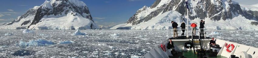
Generating Societal Value from Improved Weather, Water & Ice Forecasts in the Polar Regions
←
→
Page content transcription
If your browser does not render page correctly, please read the page content below
Report of the PPP-SERA Open Session

Generating Societal Value from Improved Weather, Water
          & Ice Forecasts in the Polar Regions

                     18 April 2018, 12:00-17:00

            European Polar Board, The Hague, Netherlands

                              Authors:

                           Machiel Lamers

                             Berill Blair

            In collaboration with the PPP-SERA Task Group
Acknowledgements We thank the World Meteorological Organisation for funding the PPP-SERA meeting, the European Polar Board for hosting the PPP-SERA Open Session, and the Environmental Policy Group of Wageningen University for sponsoring lunch and refreshments for the participants.
Table of contents

Introduction .........................................................................................................................................................................5
    Objectives .........................................................................................................................................................................5
Proceedings ..........................................................................................................................................................................6
    Opening presentations ................................................................................................................................................6
    Gita Ljubicic and Rick Thoman - Insights into Inuit communities needs ...............................................6
    Jet Sluik - Arctic Sailing ...............................................................................................................................................7
    Johann Buysse - Handling ships in first-year ice ..............................................................................................8
    Hans Hederström - Training in the Carnival Corporation fleet for safety at sea ................................9
    Plenary discussion ..................................................................................................................................................... 10

ANNEXES ............................................................................................................................................................................ 13
    Programme of the PPP-SERA Open Session .................................................................................................... 13
    Speakers of the PPP-SERA Open Session.......................................................................................................... 14
Introduction
The Polar Prediction Project (PPP) was conceived and initiated in 2012 by the World
Meteorological Organization (WMO), through its World Weather Research Programme
(WWRP), in response to rapid environmental change in the Polar Regions. The primary
goal of the PPP is to advance scientific knowledge such that society, both within and
outside of the Arctic and Antarctic, may benefit through applications of improved
weather and climate services. This includes improved understanding and prediction of
physical parameters and the ways people use the available information.
Meeting the challenge to ensure societal value from scientific efforts demands the
application of social and interdisciplinary science to better understand the
vulnerabilities and resilience of sectors and communities and the way weather, water
ice and climate (WWIC) information relates to relevant decision-making processes. It
also requires improved methods to evaluate the societal impact of WWI by measuring
social and economic value across a wide spectrum of potential user communities and
cultural, social, political, economic and geographic contexts. Improved polar prediction
requires additional observations, enhanced process understanding, or higher resolution
or more accurate numerical models. However, such advances in physical sciences must
be made accessible to potential users in a form and fashion appropriate to their needs
and resources. Across the polar regions, these users range from small indigenous
communities scattered across the circumpolar Arctic, to regional industries and
governmental activities relying on public weather services or private providers for
information, to multi-national commercial ventures that may fund their own extremely
specialized weather or sea ice products for their own uses.
In 2015 PPP established a special task group of social and interdisciplinary researchers
and service practitioners. The main interest of this group, which is referred to as PPP-
SERA (the PPP Societal and Economic Research and Applications group), is in
understanding human behaviours and decision-making processes at local and regional
levels to identify the need for and utilization of environmental prediction services. Part
of the aims of the PPP-SERA ask Group is to stimulate dialogue between researchers,
environmental forecasters and end-users. In the context of the annual 2018 meeting of
PPP-SERA in Wageningen, The Netherlands, a PPP-SERA Open Session was organised at
the premises of the European Polar Board in The Hague, The Netherlands. The Open
Session facilitated the sharing of experiences and insights with the wider community
and especially with those interested in research, policy and practice. About thirty
people attended the meeting, representing a variety of organizations and interests.
Objectives
The aims of the PPP-SERA Open Session were:
To share developments and insights from the Polar Prediction Project and the
social science agenda during the Year of Polar Prediction (YOPP);
To provide perspectives on the role and value of WWIC services from a range of
maritime sectors, and;
To exchange ideas on the societal value of enhanced WWIC services.Proceedings Opening presentations The meeting was opened and facilitated by Machiel Lamers, co-chair of the PPP-SERA Task Group. The programme of the Open Session, as well as details on the speakers and their lecture slides can be found in the Annexes of this report. The first speaker, Renuka Badhe, Executive Secretary of the European Polar Board (EPB) gave an overview of the EPB's work, and of the EPB products of interest to the PPP-SERA community. This included the newly launched European Polar Infrastructure Database (http://www.europeanpolarboard.org/polar-infrastructure/). The database, which includes detailed information on European stations, vessels and aircraft available for Arctic and Antarctic research, provides a valuable information source to support the planning of polar research fieldwork and an up to date inventory of European logistical capabilities in the polar regions. Further information about the EPB and its work is available here: www.europeanpolarboard.org Kirstin Werner from the Polar Prediction Project’s International Coordination Office followed next with a presentation of the activities during the Year of Polar Prediction (YOPP) including an update about the first of four Special Observing Periods that took place in the Arctic from 1 February to 31 March 2018. This presentation was followed by an overview of the SERA Task Group’s work by Machiel Lamers and Daniela Liggett, PPP-SERA co-chairs. This presentation focused on the evolution and objectives of PPP-SERA and gave an overview of the group’s first significant output, a scoping document on human activities in the Polar Regions. The document is a synthesis of forecasting needs emphasised by users, and the services offered by providers. This scoping document also proposes a research agenda to address existing gaps in knowledge about end users’ decision making. Gita Ljubicic and Rick Thoman - Insights into Inuit communities needs After these introductory presentations, PPP-SERA members Gita Ljubicic and Rick Thoman discussed the relevance of WWIC information for Indigenous communities in Alaska and the Canadian Arctic. They stressed the incongruence between the micro- scaled spatial and temporal experience of Indigenous communities traveling across the sea ice and the coarser resolution of weather and sea ice projection currently available through federal service providers. Traditional place-based knowledge remains critically important to Indigenous communities in the North American Arctic, even in the face of a rapidly changing environment. Poor internet connectivity, limited access to other dissemination methods and language barriers were also highlighted. In partial response to these challenges, a number of community-based monitoring networks have emerged over the last 10-15 years, that build on long-term community-research partnerships and are driven by local priorities and relevant environmental indicators.
Jet Sluik - Arctic Sailing
Jet Sluik of Tecla Sailing, a family-owned and operated sailing venture, outlined their
operations and use of weather and ice information in the Greenland, Scotland and
Icelandic Seas (see slides in annex). In 2019, they plan to cross the Northwest Passage.
Tecla is operated by Jet and her brother Gijs, who run a small 101-year-old steel sailing
vessel. Sea ice is generally avoided; they sail in the open water season. Being a sailing
ship, wind and wave information is really important. They do not care about the
temperature or precipitation. They start monitoring important weather parameters
weeks in advance and check ice charts to see if ice is going out or coming into the
Greenland fjords utilizing Danish Ice Reports. Information is usually shared within the
sailing community. Further, regular reports on the weather and vessel positions are
provided by the Greenpos system.
A variety of weather information sources is used:
Local information from local weather and radio stations;
National Met Services
o Iceland: http://en.vedur.is. Contains accurate with wind information.
o General: https://www.yr.no. Very accessible and accurate.
o YR website regarded as good for 'wind' information.
Sailmail (radio frequency modem): Grib files. The sailing company receives
pressure maps and interprets and assesses the implications themselves.
Sailing weather reports: http://www.passageweather.com
Satellite connection text weather reports: The sailing crew gets information on
low and high pressure systems and interprets these while drawing maps as they
go along
Ice charts: https://www.dmi.dk/en/groenland. Good ice charts provided by the
Danish Met Service.
Overall, it has been stressed that local knowledge of the environment and weather is
very important.
Jet Sluik also mentioned another known sailing vessel, the S/V Noorderlicht which does
not avoid sea ice and largely operates in Svalbard. Operators of this vessel want to get
frozen in as this is the experience they sell, but they fear drift ice. Temperature, again, is
not really important. Anchoring is considered a risk with drift ice. Observing closely is
important: when a big iceberg is coming, they move. The main threat is getting stuck and
going through ice too quickly. Two knots is considered a safe speed.
The following sources are used for operating the S/V Noorderlicht:
Polar View: http://polarview.met.no. This is a good website with a lot of
information but wind is such a big variable that the situation is often different
when you get there.
The YR app of MET.no: www.YR.noJet Sluik stressed that Tecla Sailing is planning to go through the Northwest Passage next year (August 2019). They are keen to take on a scientist on board to support this effort. Johann Buysse - Handling ships in first-year ice Master Mariner Johan Buysse is an experienced cargo shipper in the ice-infested Baltic Sea region and the author of a nautical education book on the topic. He provided the group with an overview of maritime operations in first-year sea ice in the Baltic Sea region, how the realities of ice navigation require specific information to feed what are often rapid decisions. These kinds of information needs for ice operation decisions can be expected to be applicable to larger areas in the Arctic during the coming decades as the Arctic increasingly becomes a first-year ice regime and as traffic is increasing and ships are getting larger. Ice navigation is risky and costly. Ice affects the speed and length of the voyages, i.e. the maneuverability of vessels. Ice poses risks to vessels and other structures via direct impact, and through icing of the vessel (this is not necessarily recorded but is very significant in terms of the cost). These risks are compounded by fatigue, lack of experience, deficiencies in communication, operational instructions, and unpreparedness of the vessel. Icing affects the stability of the vessel and equipment functionality (e.g. stuck mooring equipment). The voyage length is affected if sheltering or an alternative course are needed, associated with lots of work and efforts to de-ice the vessel in port, including extended working hours of the crew. Experience can be a mitigating factor in these uncertainties, making experienced personnel (masters, officers, pilots and hired ice-navigators) invaluable sources of decision support. Nowadays, there are courses available to train mariners on navigation in ice as well as simulators and literature to read. Ice concentration, icing and drift forecast are main issues according to Captain Buysse. However in the Baltic, icebreakers are present in certain zones, and drones can provide ice information one hour ahead; meaning navigation in these waters is relatively well- supported. Captain Buysse explains that ice seamanship requires: Voyage preparation; Vessel preparation (winterisation checklists, consulting Polar Ship Manual); Hazard awareness. With the introduction of the Polar Code. some new standards (e.g. mean daily low temperature, polar service temperature for intended area and season of operation, icing allowance) were introduced that aim to reduce polar navigation hazards. Gathering ice information and drift forecasts at www.baltice.org and its daily ice charts further support safe navigation. Gathering information for icing prediction: air temperature, sea water temperature, wind and wind direction are inserted and considered in a model. At sea (near or in ice), the following points are important:
Detecting ice and identification of the type of ice
To keep moving and avoid getting beset (when beset it is important to get
unstuck as soon as possible), assisting other vessels (happens occasionally but is
more common in the tourism industry), ramming, use of helicopters and drones
to scout the way
IR cameras on the ship to detect ice at night
Piloting and fairways
Working in-convoy with other vessels
Ice-breaker assistance: information can be provided by icebreakers about the sea ice
conditions ahead [remote assistance], and they can assist in breaking out or breaking a
channel. Ice training experience is invaluable (training or ice navigator to be hired).
Hans Hederström - Training in the Carnival Corporation fleet for safety at sea
Master Mariner Hans Hederström, Director of Carnival Corporation’s Center for
Simulator Maritime Training (CSMART) Academy, gave the group a thought-provoking
overview of the importance of human interpersonal dynamics in the decision-making
process and how critical this is when environmental information must be included.
Director Hederström talked about the importance of bridge dynamics and bridge culture
– the bridge is where the captain is often regarded as the ultimate 'decision-making'
power. He reported that in some instances, officers on the bridge may have seen issues
coming but were afraid to speak up because of the hierarchy of the ship. It was found
that the majority of incidents occurred due to human failure: captain making the wrong
decision and bridge officers essentially rendering themselves passive by-standers.
Carnival Corporation implemented a new bridge design and addressed the power
structure on the ship to ensure that human error was better managed. They now have a
navigator and a co-navigator who have to communicate all the time. When the risk is
high (e.g. close to land), a third person is added. The operations director supervises or
guides others and oversees what is going on. When sailing into port an administrator is
added to take care of administrative issues. This way the top three officers can operate
without being disturbed. Disturbances are the main reason people lose situational
awareness.
Carnival Corporation cannot operate a cruise ship based on interpretation and intuition.
They plan with a range of values for safe operation and use track corridors. The track
line was the previous focus of planning (based on single variable). Nowadays, they work
with track corridors, which are based on multiple integrated variables. Track corridors
represent safety margins for safe waters. Areas beyond the safety margins are no go
areas. There are times when local authorities provide input into Carnival’s track
corridors based on known local conditions. Safety corridors are not useful if they are
really big, on average this means about a 100 m zone. Voyage planning (i.e. corridors) is
about creating flexibility within certain margins.
Communication and shared responsibility is key. That is why Carnival Cruises works
with a clear protocol with several stages as triggers for people to speak up or escalatingoutcomes-based interventions (Probing, Acknowledging, Commenting/Recommending,
Taking Over).
In conclusion, Director Hederström notes that maritime safety is improved by:
Coordinated teamwork that overcomes the hierarchical culture on the bridge;
Voyage planning to create a shared mental model;
Visible, visualized margins for outcome-based interventions.
At the CSMART centre in Almere, captains and officers are trained to deal with a wide
range of extreme conditions, including weather and sea ice, based on the criteria above.
Plenary discussion
The presentations were followed by an open discussion, providing an opportunity for
input from other attendees and the sharing of a wide breath of experience. Discussion
topics ranged from key information needs experienced by various user groups, critical
environmental conditions or decision-making contexts in which this information
becomes indispensable, the fragmented way in which relevant WWIC is currently
provided to end-users, and potential improvements in environmental forecast delivery.
What type of information do you seek to make decisions when operating in the
Polar Regions?
Atmospheric pressure
Wind speed and wind direction, because it influences the pressure and your boat
Open water wave height and direction
Ice coverage, pressure and drift
Ice thickness and concentration, type of ice (single or multi-year ice)
Seasonal forecast for the start and end of ice season
Air temperature, to predict icing and growth
Water temperature (significant for small, non-strengthened boats to determine if
ice should be expected in the coming days)
Pressured ice
Participants discussed that it is not needed to know the exact location of icebergs and
bergy bits – an approximate location is sufficient to warn navigators to be on the
lookout and to avoid it, i.e only pass in daylight.
Communication between vessels is informal and voluntary, but really important in
operating in polar seas. There is also information sharing between local communities
and ship captains on phenomena and conditions. How can we figure out how to share
information better? To share information and help each other much more could be done
with crowd sourced data bases on critical conditions (e.g. x inches of icing on the ship).
Perhaps the ISO or IMO could support a system for building a database. On the other
hand, ships and crew are at times afraid of reporting because they think there will be
retributions. As a related point: Change is much harder to enact with regards to shore-based practices and management, than it is within the ship’s management – because
shore-based management often creates new procedures to insulate themselves from
risks (e.g. legal risks).
It was mentioned that the ice data is made far too difficult for people to use. The
resolution is too coarse for operational use and there is criticism on the use of the
international Ice Egg standard. Overall, there is too much information available that is
useless; much searching is to be done for the useful information. There is a lack of a
common platform, or a one-stop-shop for information that is updated more frequently.
The most difficult time to navigate is at the beginning and at the end of the ice season.
For seasonal planning it is sufficient to look at statistics – such as average time ice starts
in an area. This is good but for voyage planning updates are needed every six hours at
minimum.
Are more or better observations and modelling always better in view of societal
needs?
It is important to develop people’s or operators’ adaptive capacity and this can only be
developed by experience or in simulators. Preparing people properly is the most
important thing. Related to this, enhanced training and experience with the
interpretation of various data sources is important.
How do you adapt and make decisions?
There are always at least two scenarios for action are ready and if needed a third one
can be made up. Voyage planning needs to be flexible in order to be able to make
changes.
What about variability?
For example cruises are selling berths 2-3 years ahead, but what about variability?
There is a need for different outlooks (hourly to yearly to interannual etc.) for planning
purposes.
Satellite images are needed on board – not just the ice chart. It really comes down to
experience to be able to interpret satellite imagery.
It was mentioned that captains of expedition cruise ships are all different. How they
work or what they use in terms of information is very personal. It all depends on the
culture of the ship and the bridge. There are often different people from different
countries and different culture at work on the bridge.
Several important commonalities emerged during the course of the session. These
included:
Access to information for the appropriate spatial and temporal scale
Observations, analyses and forecasts, of whatever type or format, are only parts
of a richer decision matrix Personal experience and non-environmental factors also play important roles in
outcomes
Through Open Sessions such as this one, the aim of the SERA Task Group is to help PPP
advance its mission in the “…development of improved weather and environmental
prediction services for the polar regions, on time scales from hourly to seasonal.” We
aim to achieve this by bringing social science expertise to the complex web of WWIC
information use in the polar regions, and to investigating the extent to which forecasting
enterprises can maximize value to society via improved science.ANNEXES
Programme of the PPP-SERA Open Session
12:00 Registration and lunch
13:00 Opening: Machiel Lamers
13:05 Word of welcome Renuka Badhe
13:10 Introducing the Polar Prediction Project Kirstin Werner
13:20 Overview and history of PPP-SERA Daniela Liggett/Machiel
Lamers
13:35 Insights into Inuit communities needs Gita Ljubicic/Rick Thoman
13:55 Arctic sailing Jet and Gijs Sluijk
14:15 Handling ships in first year ice Johan Buysse
14:35 Training in the Carnival Corporation fleet
for safety at sea Hans Hederström
15:00 Coffee break
15:15 Plenary discussion
17:00 ClosureSpeakers of the PPP-SERA Open Session
Machiel Lamers: Steering committee member of the Polar Prediction Project, Co-
chair of the PPP-SERA group, Lead-PI of the SALIENSEAS project
and Associate Professor at the Environmental Policy Group,
Wageningen University and Research, the Netherlands
Renuka Badhe: Executive Secretary of the European Polar Board, The Hague, The
Netherlands
Kirstin Werner: International Coordination Office for Polar Prediction, Alfred
Wegener Institute, Bremerhaven, Germany
Daniela Liggett: Steering committee member of the Polar Prediction Project, Co-
chair of the PPP-SERA group and Senior Lecturer at Gateway
Antarctica, University of Canterbury
Gita Ljubicic: Member of the PPP-SERA group, works with Inuit communities in
the Canadian Arctic, and Associate Professor at Carleton University,
Ottawa, Canada
Rick Thoman: Member of the PPP-SERA group, Climate Science and Services
Manager, US National Weather Service, Alaska Region.
Jet Sluik: Tecla Sailing, The Netherlands
Johan Buysse: Master Mariner, MSc (Nautical), marine cargo surveyor and cargo-
superintendent, author of the book “Handling Ships in First-Year
Ice”, Belgium
Hans Hederström: Experienced mariner, Director of the CSMART simulation centre,
part of the Carnival Corporation & plc Group, Almere Poort, The
NetherlandsYou can also read