Generation of high-resolution spectral and broadband surface albedo products based on Sentinel-2 MSI measurements, and Super-Resolution ...
←
→
Page content transcription
If your browser does not render page correctly, please read the page content below
Generation of high-resolution
       spectral and broadband surface
       albedo products based on
2021

       Sentinel-2 MSI measurements,
       and Super-Resolution Restoration
       from single and repeat EO images

       Jan-Peter Muller,
       j.muller@ucl.ac.uk
       Head, Imaging Group, UCL-MSSL
                          VH-RODA Workshop 2021 | 20-23 April 2021 | Slide 1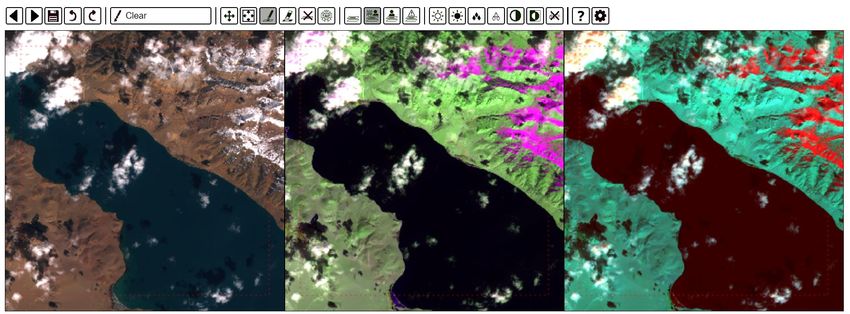
2021

       Generation of high-resolution spectral and broadband surface
       albedo products based on Sentinel-2 MSI measurements
       Jan-Peter Muller, Rui Song and Alistair Francis, UCL-MSSL*

       *Work supported by ESA under science in society ‘Generation of high-
       resolution spectral and broadband surface albedo products based on
       Sentinel-2 MSI measurements (HR-AlbedoMap)’
                                                    VH-RODA Workshop 2021 | 20-23 April 2021 | Slide 2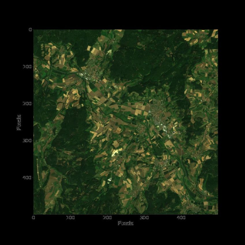
HR Albedomap retrieval: Overall objectives, previous work and context

• Overall Objectives for the development of high resolution land surface albedo retrieval using Sentinel-2 MSI:
   ➢ Generate 10m/20m spectral & broadband albedo of the Earth’s land surface using Sentinel-2 +MODIS/VIIRS albedo
   ➢ Improve upon existing S2 cloud masks using novel deep learning/AI techniques
   ➢ Improve upon existing S2 atmospheric correction Sen2Cor using new UCL-SIAC method (Feng et al., 2020)
   ➢ Apply EU-Copernicus Land Service GbOV method to provide spectral and broadband land surface albedo using
         optimal estimation to fill in gaps due to persistent cloud cover
   ➢ Validate results using broadband (shortwave) albedos from GbOV and spectral BRDFs from RADCALNET (courtesy CNES)
• Previous work on Ground-Based Observations for Validation (GBOV) of Copernicus Global Land Products:
    ➢ Albedo values upscaled from 20+ tower sites since 2012 were produced to compare against MODIS, CGLS and MISR
       albedo products. (https://land.copernicus.eu/global/gbov/)
                                                      1. Song, R.; Muller, J.-P.; Kharbouche, S.; Woodgate, W.
                                                         Intercomparison of Surface Albedo Retrievals from MISR, MODIS,
                                                         CGLS Using Tower and Upscaled Tower Measurements. Remote
                                                         Sens. 2019, 11, 644.
                                                      2. Song, R.; Muller, J.-P.; Kharbouche, S.; Yin, F.; Woodgate, W.; Kitchen,
                                                         M.; Roland, M.; Arriga, N.; Meyer, W.; Koerber, G.; Bonal, D.; Burban,
                                                         B.; Knohl, A.; Siebicke, L.; Buysse, P.; Loubet, B.; Leonardo, M.;
                                                         Lerebourg, C.; Gobron, N. Validation of Space-Based Albedo
                                                         Products from Upscaled Tower-Based Measurements Over
                                                         Heterogeneous and Homogeneous Landscapes. Remote
                                                         Sens. 2020, 12, 833.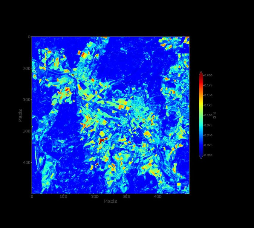
HR Albedomap retrieval: processing chain from level-1C to final spectral albedo

                                         MODIS/VIIRS
                                           prior
          CAMS

       MODIS/VIIRS
                           SIAC          Surface BRFs             inversion              HR Albedo
         BRDF

      Sentinel-2 L1C                                    BoA-BRF
                                                        +sigma

                          DeepLab        Cloud Mask                           Spectral     Broadband   RGB
                            v3+                                               +sigma       +sigma      +sigma

        ToA-BRF        S2 training-set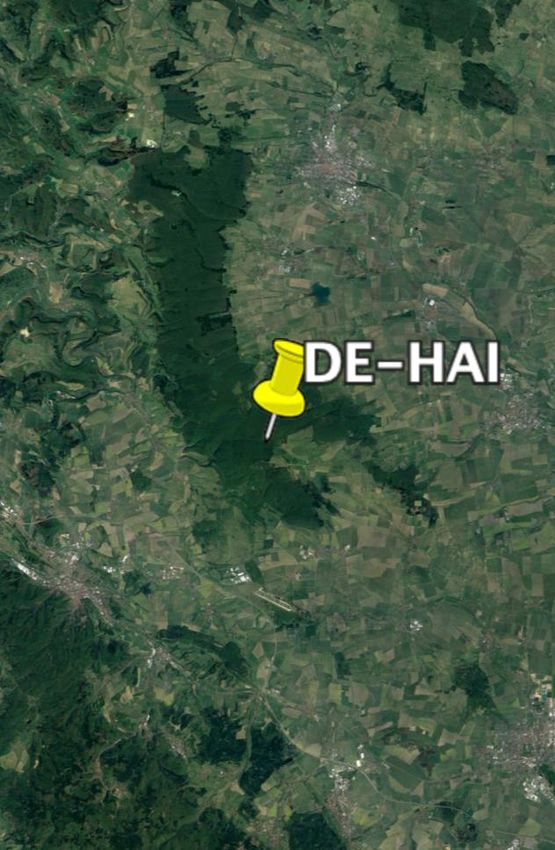
AI cloud detection: Schema

A. Francis et al. in preparation
AI cloud detection: Sentinel-2 dataset
Alistair Francis, in collaboration with John Mrziglod (recent ESA YGT, now at WFP)

➢ Motivated by lack of labelled Sentinel-2 cloud data
➢ Emphasis placed on number of scenes, not number of pixels
➢ 513 1022-by-1022 subscenes taken from completely random
  selection of 2018 Sentinel-2 L1C catalogue
➢ Fast and accurate annotations made using IRIS (see next slides)
➢ Shadows also included where possible (424/513 subscenes)
➢ 95% agreement between annotators on 50 scene validation set
➢ >1400 unique views on Zenodo so far, many more downloads
  (some, we think, not legitimate)

    https://zenodo.org/record/4172871
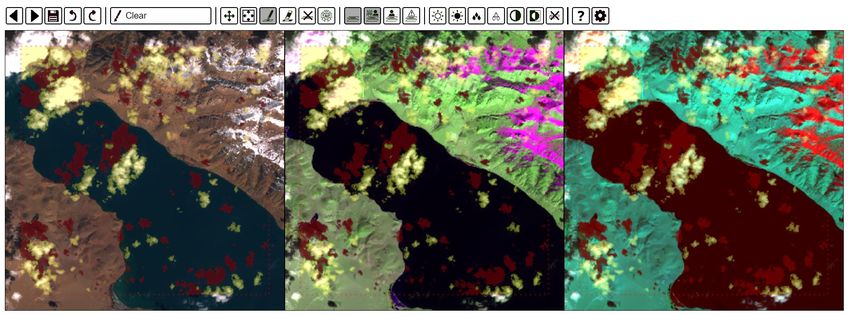
AI cloud detection: Sentinel-2 dataset

                            https://github.com/ESA-PhiLab/iris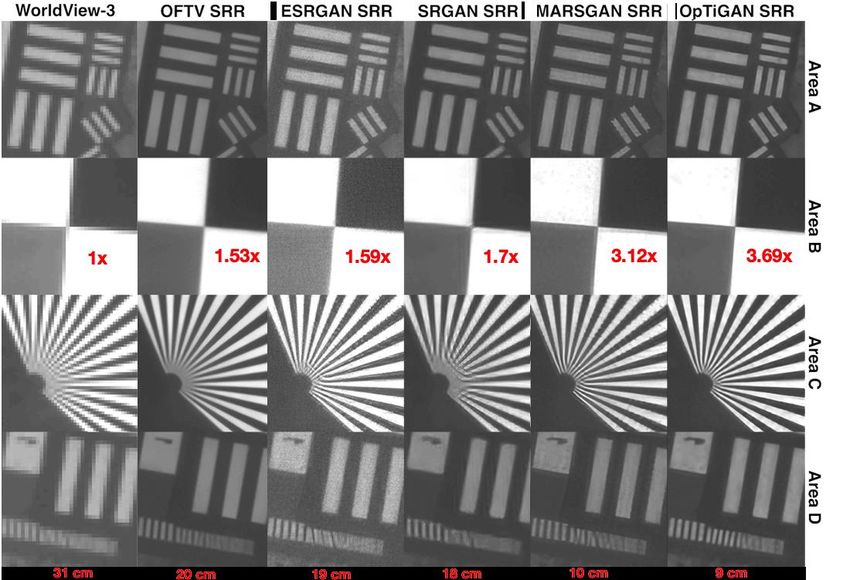
AI cloud detection: Sentinel-2 dataset

                                https://github.com/ESA-PhiLab/iris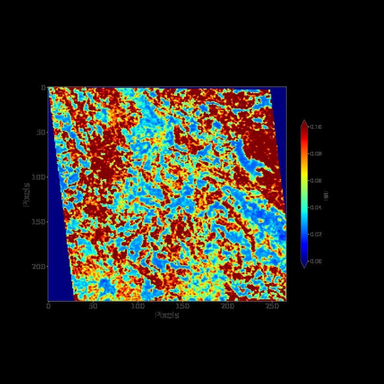
AI cloud detection: Training and Validation

➢ Dataset split into 40% training, 10% validation,                                 Total test set: 257 subscenes
  50% testing                                                                           Model         Accuracy   F1-score

➢ Comparisons made between labelled ground truth                                   L1C product mask    83.1%     83.6%

  and the three models                                                                CloudFCN         91.4%     91.6%

➢ DeepLab v3+ substantially better overall and for                                   DeepLab v3+       94.0%     94.3%

  specific surface types (e.g. Snow/Ice as shown)                                  Snow/Ice: 41
➢ CloudFCN* performs roughly as well as it did on                                  subscenes
  Landsat 8, however perhaps the lack of pre-trained                                    Model         Accuracy   F1-score

  weights and a fewer layers leads to poorer                                       L1C product mask    73.8%     75.7%

  performance than DeepLab v3+                                                        CloudFCN         81.4%     82.0%
Francis, A.; Sidiropoulos, P.; Muller, J.-P. CloudFCN: Accurate and Robust Cloud     DeepLab v3+       83.1%     83.6%
Detection for Satellite Imagery with Deep Learning.Remote Sens. 2019, 11, 2312
HR albedo retrieval processing chain
Sentinel-2 MODIS CAMS 500-m S2 MODIS
TOA BRF BRDF Prediction Surface BRF Prior
AI Cloud Albedo/BRF
Detection SIAC Calculation
S2 Cloud S2 Surface
Mask BRF
Reprojection & Albedo/BRF
Aggregation Matrix (n-D)
S2 Masked
Surface BRF
enough cloud- Albedo
free pixels? Inversion
Yes
Spatial resampling 20-m
gap-filling Albedo
EEA: Endmembers Extraction 20-m S2
Algorithms based on Surface BRF
Downscaling
Winter, M. E., “N-FINDR: an
algorithm for fast autonomous EEA processing
spectral end-member determination
in hyperspectral data”, presented at S2 EEA
Abundance
10-m
Albedo
Imaging Spectrometry V, Denver,
CO, USA, 1999, vol. 3753, pgs. 266-
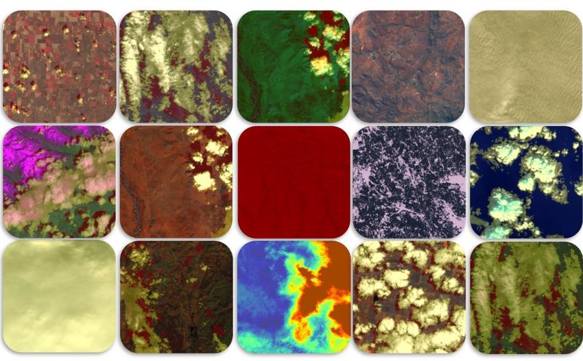
275 R. Song et al. in preparationEndmember extraction analysis
Number of pixels with abundance > 0.7:
Type A: 34524
S2 10km * 10km area at Hainich, Type B: 1353
Germany (RGB BRF) Type C: 17
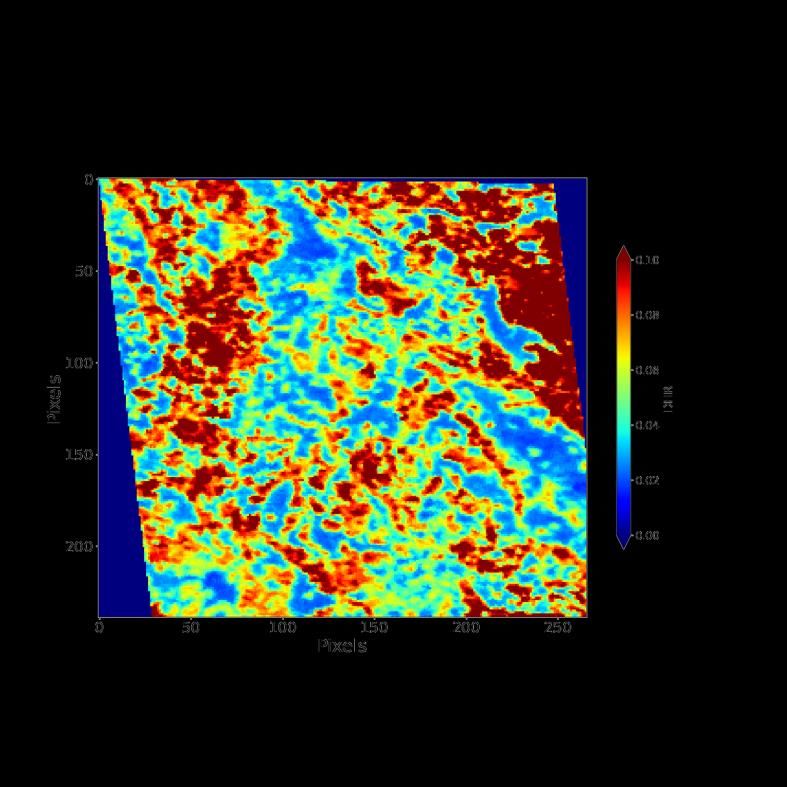
Type D: 16500-m BRF, DHR and BHR are calculated at S2 solar and viewing geometries, using
kernels from MCD43A1 or VNP43A1
665nm BRF 665nm DHR 665nm BHRHR-Albedo is retrieved from an endmember-based Albedo-to-BRF regression model. S2 10km * 10km area at Hainich, 10*10km area, 665nm Germany at 10m (RGB BRF) spectral albedo at 10m
FLUXNET SW-BHR vs S2-BHR
at the footprint scale

                                                    10km
                           10-m resolution albedo            20-m resolution shortwave
                            (R,G,B composition)                  broadband albedo

                                    10km                                10km
                                                           Histogram of S2 albedo within tower
                                                           FoV on 24th July 2018. Tower
                                                           measured BHR is 0.168±0.0016,
                                                           using tower albedometer
                                                           measurements over a 30-day
                                                           window.
                                                           N.B. 500m projected FoV shown,
                                                           actual calculated footprint is 377m
SURFRAD SW-BHR vs S2-BHR
at the footprint scale
10km 10km
10-m resolution spectral 20-m resolution shortwave
albedo (R,G,B composite) broadband albedo
N.B. Tower footprint in S2 ≈230mS2 spectral
albedo
assessment
RADCALNET BHR
courtesy of CNES
10-m resolution spectral 20-m resolution shortwave
albedo (R,G,B composite) broadband albedoSummary and Future work
▪ Have developed automated processing system for fusion of Sentinel-
2/MSI BRF with common MODIS/VIIRS BRDF/albedo spectral bands to
2021
generate full Sentinel-2 tiles of pixels consisting of:
▪ 4*10m (BHR & DHR)
▪ 3*20m spectral albedo (BHR & DHR) products
▪ 3*20m broadband products (VIS, NIR & SW)
▪ Processing chain has been developed for fully automated processing
from S2+MODIS/VIIRS
▪ Work proceeding with F-TEP and FS-TEP (via ESA NoR) for future
service to generate “on demand” albedo products
▪ Working with 7 end users in agricultural and forestry area for alpha
test and assessment
VH-RODA Workshop 2021 | 20-23 April 2021 | Slide 172021
Super-Resolution Restoration from single and repeat EO images
Yu Tao and Jan-Peter Muller*, UCL-MSSL
* Work supported by UKSA-CEOI SRR-EO, UKSA-Aurora and UCL
Enterprise (SpaceJump)
VH-RODA Workshop 2021 | 20-23 April 2021 | Slide 18Super-resolution Restoration - motivation
• Higher spatial resolution imaging data is desirable in many scientific
and commercial applications of Earth Observation satellite data.
2021
• Given the physical constraints of the imaging instruments, we
always need to trade-off spatial resolution against launch mass,
usable swath-width, and telecommunications bandwidth for
transmitting data back to ground stations.
• One solution to this conundrum is through the use of super-
resolution restoration (SRR).
• SRR refers to the process of restoring a higher-resolution image
detail from a single or a sequence of lower-resolution images.
• SRR can be achieved by combining non-redundant information
contained within multiple LR inputs, via a deep learning process, or
via a combination of the two. We explore the latter here over CEOS-
WGCV geometric calibration site in Inner Mongolia, China
VH-RODA Workshop 2021 | 20-23 April 2021 | Slide 19Super-resolution Restoration – UCL algorithms
▪ Imaging Group (UCL-MSSL) has an 8 year track-record of developing state-of-the-
art SRR techniques applied to Earth and Mars observations.
▪ Developed techniques include traditional photogrammetric and stochastic
2021
approaches, deep-learning based approaches, and novel approaches combining
the two. These include:
▪ The Gotcha Partial-Differential-Equation based Total Variation SRR (GPT-
SRR) system to exploit multi-angle information from repeat-pass
observations (Tao & Muller, PSS, 2015).
▪ Multi-Angle Gotcha image SRR with GAN (MAGiGAN; Tao & Muller,
SPIE, 2018 & RS, 2019) for point-and-stare EO images or multi-angle
observations (e.g., MISR).
▪ The state-of-the-art Multi-scale Adaptive-weighted Residual Super-
resolution Generative Adversarial Network (MARSGAN; Tao & Muller,
RS, 2021a) deep residual network for single-image SRR.
▪ Optical-flow and Total-variation based image SRR with MARSGAN
(OpTiGAN; Tao & Muller, RS, 2021c) for continuous EO image
sequence or “point-and-stare” video frames.
VH-RODA Workshop 2021 | 20-23 April 2021 | Slide 20Super-resolution Restoration – UCL algorithms
Our developed SRR techniques were demonstrated with multiple EO data with a wide-
range of spatial resolutions (for single-band, colour, and multi-spectral), including
300m Sentinel 3 OLCI, 275m MISR, 10m Sentinel 2, 4m and 0.75m UrtheCast
Deimos-2, 1.1m SSTL Carbonite-2 video, 70cm SkySat, and 31cm WorldView-3.
2021
Many photographic
SRR software only
increases the image
passive resolution,
invents visually
pleasing but fake
textures, and creates
artefacts.
Our SRR techniques
improve the image
effective resolution
and do not invent
artefacts.
WorldView-3 (©Digital Globe, Worldview-3 image 2020 - Data provided by the European Space Agency), OpTiGAN SRR
(Figure taken from Tao & Muller, 2021), Labelled reference ground truth (Figure taken from Zhou et al., 2016)
VH-RODA Workshop 2021 | 20-23 April 2021 | Slide 21SRR – examples for WorldView-3
WorldView-3
(©Digital Globe,
Worldview-3
image 2020 -
Data provided by
2021
the European
Space Agency;
Figure taken from
Tao & Muller,
2021b)
Average
enhancement
factor
SRR results from
SRGAN (Ledig et
al., 2017),
ESRGAN (Wang
et al., 2018),
MARSGAN (Tao et
al., 2021), OFTV
(Tao & Muller,
2021a), and
OpTiGAN (Tao &
Muller, 2021c).
Effective resolution VH-RODA Workshop 2021 | 20-23 April 2021 | Slide 22An example of Sentinel-2 single image SRR
• Input image ID S2A_MSIL1C_20201018T033751_N0209_R061_T49TCF_20201018T063447
• Used the same single image MARSGAN model (without retraining) as used for WV-3, SkySat,
Deimos-2 SRR (Tao & Muller, RS, 2021c)
2021
VH-RODA Workshop 2021 | 20-23 April 2021 | Slide 23Summary and Possible Future Service
▪ Traditional multi-image photogrammetric approaches (e.g., OFTV) generally produce little or no
artefacts, and have better restoration of small objects (e.g., small bar targets in this example), but
the edge sharpness is generally low (i.e., blurry outlines).
2021
▪ Deep learning based approaches (e.g., SRGAN, ESRGAN, MARSGAN) generally produce sharper
edges, but are more likely to produce artefacts.
▪ SRR techniques that combine the two, can restore both high-frequency components (e.g.,
edges, textures) and low-frequency components (e.g., individual objects) whilst having good control
on artefacts, and are empirically more likely to produce optimal results and are more robust to
different datasets.
▪ Even though, SRR Proposed SRR service
results (from any algorithm) (SpaceJump 2021)
may still differ from sensor
to sensor, and scene to
scene – a future streamlined
SRR processing system (if
funded) should be capable
of (automatically) selecting
the best algorithm/method
to use for the given scene.
VH-RODA Workshop 2021 | 20-23 April 2021 | Slide 24You can also read