Geography - North Mead Primary Academy
←
→
Page content transcription
If your browser does not render page correctly, please read the page content below
Geography
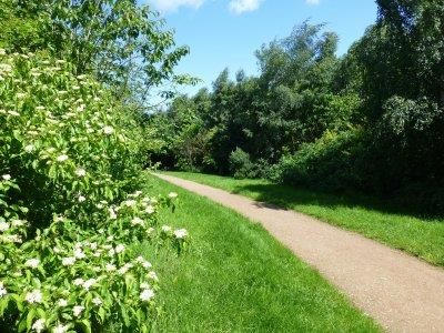
Year 1 – The Gruffalo
Locational Knowledge Place Knowledge Human and Physical Geography Geographical Skills and Fieldwork
North Mead is in Brocks Hill is a park In Britain we have woodlands. Geographers create maps
Leicester. which has a woodland, Brocks Hill has small areas of woodland. to show what features
Brocks Hill is in play area, café and The United Kingdom has a seasonal climate. are in different areas.
Oadby which in picnic areas. A seasonal climate means we have different Some parks such as
next to Leicester. Brocks Hill is home to weather at different times of the year. Brocks hill, have maps
Leicester is in the different types of In spring the temperature begins to rise, some to follow and to show
Leicestershire, animals. plants begin to grow and some animals have what is there.
England. Brocks Hill has different their young. The maps have symbols
England is in the types of trees. In summer, the temperature is at its highest, such as picnic areas
UK. Brocks Hill has streams some plants are in bloom and animals have and toilets.
The UK is in flowing through it. more food to eat. These symbols have a
Europe. Brocks Hill is In autumn, the temperature begins to lower, key which show what
The UK has a surrounded by houses tress lose their leaves and some animals start they mean.
seasonal climate. and roads on two sides gathering food for hibernation. Geographers use:
and fields on the other In winter, the temperature is at its lowest, some binoculars to identify
sides. trees are bare and some animals hibernate. birds and different trees,
Brocks Hill has paths. An ecosystem is like a community and shows a compass to show
Not all woodlands are how all the living things are connected. direction of different
like this. In an ecosystem, every part is important and features.
The Gruffalo is set in a relies on the other parts. This means that there Geographers can use
similar woodland. are some animals that eat other animals and beakers to collect
other animals eat the plants. examples of soils and
insects.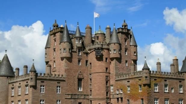
Year 1 – George Saves the World by Lunchtime
Locational Knowledge Place Knowledge Human and Physical Geography Geographical Skills and Fieldwork
United Things that are familiar to us are Maps may show visible features, We use a compass to find
Kingdom our homes, shops, landmarks etc. such as rivers and lakes, direction.
consists of 4 (temple, train line, park, and shops). woodlands, buildings, and roads. Directional language helps
countries; North Mead is on Northfield Road. Physical features show natural describe direction/location such
England, There is a shop, hairdressers, objects such as mountains and as north, east, south, west,
Wales, launderette, take away and a car rivers. (Watermead, River Soar, …) left and right.
Scotland, and wash on Gipsy Lane. Human features are things that are A map is a picture or chart
Northern There is a train track that crosses built by humans such as bridges that shows the features of an
Island Gipsy Lane. and roads. (Rail line, temple, roads) area
The capital city Under the bridge on Gipsy Lane, is Sustainability is finding ways to We can identify simple key
is London the Mandir. save the Earth. features on a simple map, i.e.
Leicester (our Under the bridge, there are other There are ways to be sustainable - a river, hills, buildings.
local area) is shops along Gipsy Lane, such as Recycle, Reduce, Reuse. We can use locational language
a city in the Lidl. People can travel around easily by to describe location such as,
country called North Mead Primary Academy is car, bus, and rail. near, next to, behind etc.
England. situated on the Northfield estate. People use public transport to travel We can use different maps to
NMPA is North Mead is surrounded by around. show how things have
located in houses, shops and roads. There are places called allotments changed in Leicester.
Leicester. Side roads and main roads connect where people grow their own plants, Geographers also look at ways
Northfield with Leicester city centre. fruit and vegetable to eat, rather to improve their local
than buying them from a shop or environment.
market. Geographers look at ways of
Compost - Composting is a term that being more sustainable, such
is used when food and different as riding bikes and reducing
materials are broken down. waste.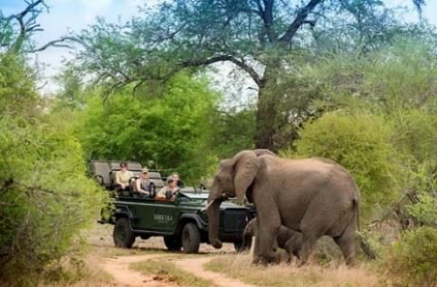
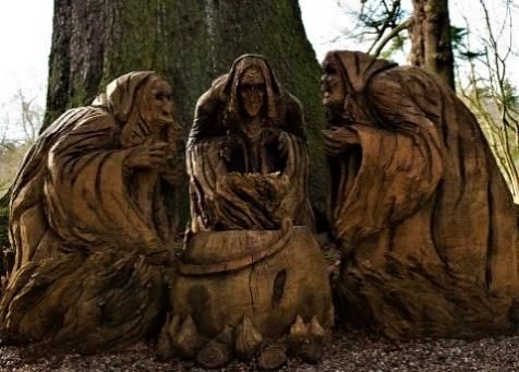
Year 2 - Macbeth
Scotland
Locational Knowledge Place Knowledge Human and Physical Geographical Skills and
Geography Fieldwork
Scotland is a Macbeth lived in Scotland. Scotland’s Geographers use
country in the Macbeth’s castle is in Inverness in Northern Scotland. landscape is split digital technology
United Kingdom. Inverness is in the highland region of Scotland. into 3 types - to observe
Scotland is north Inverness Castle sits on a cliff overlooking the River The Southern areas/landmarks
of England and Ness Uplands, the using satellites.
part of the United This is north of the Grampian Mountains. Central Lowlands They also use it to
Kingdom. The castle was built on the River Ness because it is a and the Northern look at natural
Scotland is colder good location for defence, travel and water. Highlands and features such as
than England Glamis Castle is further south than Inverness. Islands rivers, mountains
because it’s Glamis Castle is situated beside the village of Glamis Glamis is set in and coastlines.
further north. in Angus, Scotland. a broad and We can use this
Scotland still has The Castle is near the Firth of Tay. fertile lowland technology to map
a moderate, Dunsinane Hill is a hill of the Sidlaw Range near the valley. out a journey using
seasonal climate village of Collace in Perthshire, Scotland. Inverness is in google maps.
The UK is above Birnam Wood is near Birnam in Perthshire, Scotland. the highlands. Use aerial
the equator and It is a wood with a famous oak tree. This area is photographs to
is therefore in the largely identify key
Northern Inverness Hong Kong mountainous and physical features
hemisphere. Climate Seasonal subtropical forms the highest of Scotland.
The UK is above moderate ground in the UK. Geographers use
the tropic of Human Low Densely populated Glamis Castle is Ordinance Survey
cancer, which geography population in the central part Maps to help them
means it has a Physical Mountainous Island and deep of Scotland. explore around
moderate climate. geography water harbour. This is a wide areas.
Trade tourism Services and tourism and fertile part of
land in a valley.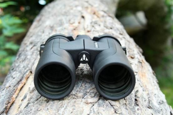
Year 2 - Chopsticks
Hong Kong
Locational Knowledge Place Knowledge Human and Physical Geography Geographical Skills and
Fieldwork
There are 7 Victoria Harbour is on Hong Kong Transport Geographers can use
continents and Island. Over 90 per cent of daily trips are digital technology to
5 oceans. It is named after Queen Victoria. made on public transport e.g. monitor and identify the
China is in Hong Kong has the world's railways, buses and ferries. following Hong Kong
South East largest number of skyscrapers. The Mass Transit Railway (MTR) is landmarks, Victoria
Asia. Hong Kong is fairly an long passenger rail network, Harbour, Victoria Peak,
Hong Kong is in hilly/mountainous with steep connecting different stations Ocean Harbour, Tian
China on the slopes. Vehicle traffic is extremely congested Tan Buda, Disney land,
southern coast. Hong Kong is located near the Work Lantai Island.
Hong Kong has Pearl River. It is a rich, developed city. Directional language
a humid climate. Hong Kong is a Chinese island. It is known as one of the biggest helps describe
It is in the Between Hong Kong Island and business hubs in the world e.g. direction/location such
Northern the Kowloon Peninsula lies travel agents, call centres, app as north east, south
hemisphere. Victoria Harbour, one of the developers & manufacturing. east, south west, east
It is just above world's deep-water harbours. Settlement west, left and right.
the tropic of The climate of Hong Kong is Hong Kong has a high population
cancer. subtropical, with very mild with over 7 million people.
winters and hot, rainy, and They are trying to provide more
muggy summers residential homes for people.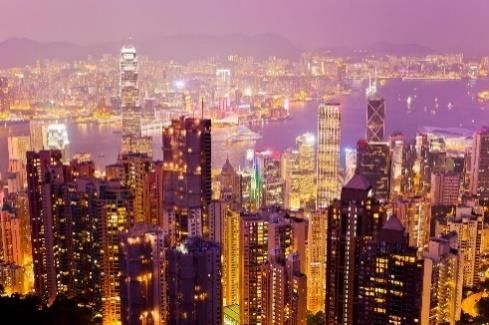
Year 3 – Escape from Pompeii
Locational Knowledge Place Knowledge Human and Physical Geography Geographical Skills and Fieldwork
Mount Vesuvius is Pompeii is most famous for The Earth consists of four layers –
near Naples, Italy. its eruption that took place Crust, mantle, outer core, inner core. Geographers make
Italy is in Europe, in the year 79 A.D., when The Earth’s crust is made up of large diagrams of volcanoes.
which is in the the volcano buried the plates that move on the mantle. These
Northern Hemisphere. ancient Roman city under a are called tectonic plates and are made Geographers use digital
It is further south thick carpet of volcanic ash. of solid rock. technology to locate,
than the UK, which There is a modern town Active is a volcano that erupts identify and compare
means it is warmer of Pompeii which can be regularly. different volcanoes.
because it is closer to incredibly busy and hot Dormant means it hasn’t erupted for a
the Equator. during peak tourist season. while. We can use aerial
It sits between the
The climate of Naples, Extinct means volcanoes will not erupt photographs to identify
African and Eurasian anymore. key physical features of
is Mediterranean, with mild,
tectonic plates. How volcanoes erupt? the landscape.
rainy winters and hot,
Compare weather 1. Pressure builds up inside the magma
sunny summers.
patterns in Italy with chamber.
the UK. 2. Magma rises from the magma chamber
through cracks or weaknesses in the
Earth's crust.
3. When this pressure is released, magma
explodes to the surface causing a
volcanic eruption.
4. The lava from the eruption cools to form
new crust.
5. Over time, after several eruptions, the
rock builds up and a volcano forms.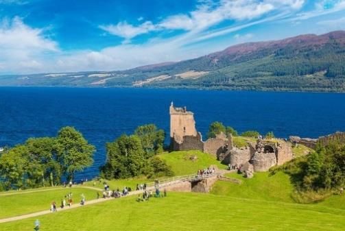
Year 3 - Outlaw
Locational Knowledge Place Knowledge Human and Physical Geography Geographical Skills and Fieldwork
Sherwood Forest is Sherwood Forest is a royal The United Kingdom has a seasonal Geographers use maps with
an ancient woodland forest in Nottinghamshire, climate. more complex keys, to
in Nottinghamshire. England, famous by its The climate in England is called show what features are in
historic legend of Robin Hood. temperature maritime – this means it is areas.
Nottingham is a city damp and varied.
in the East Sherwood Forest is a 450 This climate means that we have Ordinate survey maps tell
Midlands. acre country park in deciduous trees, as well as evergreen. us the direction (N, E, S,
Nottinghamshire. In general we have warm summers and W), also use grid
It is in the county cool winters. The summers are cooler than referencing.
of Nottinghamshire. Sherwood Forest is a those on the continent but the winters are
pine forest with areas of milder too. This is because of the Gulf Understand and use a
The United Kingdom birch, oak, sweet chestnut, Stream. four figure grid reference
consists of the and beech. There are open when using and
following countries; areas where the Coniferous Forest Deciduous Forest interpreting a map of the
England, Wales, and mature trees have been Leaves stay green all Leaves change colour United Kingdom.
Scotland and harvested and allowed to year. They do not fall in autumn and fall
Northern Island. become heathland. off the tree. off. They re-grow in Geographers use and
spring. understand 8 points of a
London is the In the middle of Sherwood They grow in They grow in compass to show direction
capital city of Forest stands the Major oak countries that have countries where of different features.
England and the UK. tree said to be more than short summers and summer and winter
1,000 years old. It’s so vast long winters. are equal length. They will also use data
that it would take eight people They keep animals Animals store food collection to identify and
holding hands around it to warm and provide as it’s not available record different trees of the
give it a hug, and the weight food for them over in the winter. forest.
of its canopy is so great it the long winters.
has to be held up by wooden Located in the U.K. Located in the We use binoculars to
supports. e.g. Sherwood forest. northern areas of the identify different trees and
world E.g. Sweden features in the woods.
and Finland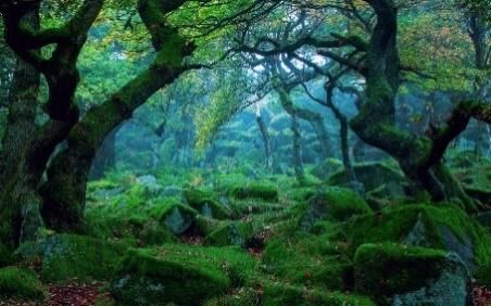
Year 4 – The Butterfly Lion
Locational Knowledge Place Knowledge Human and Physical Geography Geographical Skills and Fieldwork
Timbavati lies within the Kruger Timbavati is in the Krugar National The climate is mild Geographers use digital
National Park in South Africa park. winters from May to technology to monitor
South Africa is at the Krugar National park is located in September and hot National Parks.
southernmost tip of Africa. the Mpumalanga province. summers from November Geographers use digital
South Africa lies below the tropic In Timbavati the temperature ranges to March. technology to observe the
of Capricorn. from 26-33 degrees Celsius. Rainfall mostly occurs in topography of regions and
To the North is Namibia, Animals that can be found in the the summer months in countries.
Botswana and Mozambique. park are lions, white lions, the form of Geographers use graphs to
To the West and South is the elephants, leopards, black rhinos, thunderstorms. measure the average
Atlantic Ocean. giraffes and baboons. Veld is wide open flat temperature across the
To the East is the Indian Ocean. It is a popular tourist location. rural landscape covered year.
South Africa has a temperate People can go on holiday on safari. in grass or low scrub.
climate which means Timbavati National Park was The Blyde River Canyon
environments with moderate established by conservation flows through the
rainfall, spread across the year, landowners to protect the wildlife province.
with sporadic drought, mild to and habitats of South Africa from There are various water
warm summers and cool to cold extensive farming, re-routing of holes for the animals to
winters. water routes, coastal development drink from.
The country’s capital is Pretoria. and poaching.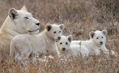
Year 4 – The Iron Man
Locational Knowledge Place Knowledge Human and Physical Geography Geographical Skills and
Fieldwork
The United Kingdom Norfolk has over 90 miles Coasts Geographers use digital
is an island in of coastline. The coast: Where the land meets the sea. technology in the form
Europe. Hemsby is a village on the Erosion: The wearing a way of rock, stones of aerial views to
Norfolk coast. and soil by the sea and waves. monitor coastal erosion
Norfolk is the Hemsby borders the villages Transport: The carrying away of material by at Hembsy.
Eastern most of Winterton-on-Sea and rivers, waves, wind, or glaciers. They have to compare
county of the Scratby. Deposit To drop material; waves deposit sand what has happened to
United Kingdom. It is in the district of Great and small stones to form beaches. an area of land over
Yarmouth. Bay - a smooth curve of coast between two time.
To the North and Coastal erosion has headlands. Geographers have to
East of Norfolk is destroyed a number of Beach An area of sand or small stones, balance the human and
the North Sea. homes and others are deposited by waves. physical geography.
threatened. Coastal defences Barriers to protect areas of
The United Kingdom The government won’t pay the coast from erosion or flooding
consists of the to reduce the risks of Tides the rise and fall in sea level, due
following countries; erosion so home owners mainly to the pull of the moon.
England, Wales, have to find this Headland: Land that juts out into the sea.
and Scotland and themselves. Sand dunes: A hill or ridge of sand piled up
Northern Island. There are campaigns to by the wind is called a sand
raise money for sea dune. Dunes may form wherever there is a
London is the defences. lot of loose sand and enough wind to move
capital city of Currently they use it. Beaches and deserts are common places
England and the honeycomb concrete blocks for dunes.
UK. as sea defences. This Cliffs: type of landform on the surface of the
money was raised by the earth. Tall, steep rocks created by erosion
local people. and have vertical faces.
These are expected to give Estuaries: area where seawater mixes with
50 years of protection. freshwater found along the coast.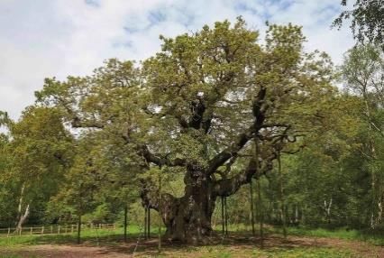
Year 5 – The Great Kapok Tree
Locational Knowledge Place Knowledge Human and Physical Geography Geographical Skills
and Fieldwork
The Amazon The Amazon rainforest is The Water Cycle Geographers
Rainforest is the largest tropical use digital
in South rainforest in the world. Water on Earth is constantly moving. It is recycled over and over technology in
America. The Amazon rainforest again. This recycling process is called the water cycle. the form of
The Amazon accounts for more than 1. Evaporation – the sun heats up the water and turns it into aerial views to
Rainforest half of the entire world's water vapour. The water vapour then rises into the air. monitor the
spreads across remaining rainforests. 2. Condensation – the water vapour cools down and changes rainforest.
most of the The Amazon rainforest is back into tiny drops of water forming clouds. They have
North West of home to 10% of the known 3. Precipitation – the clouds get heavy and the water falls used these
Brazil, as well species in the world. back to the ground in the form of rain or snow. images to see
as parts of The Amazon rainforest is 4. Collection – the rain and snow run over the land and the effects of
Bolivia, Peru, also referred to as the collects on lakes or rivers, which then takes it back to the deforestation.
Ecuador, ‘Lungs of the Planet' sea.
Colombia, because it produces more
Venezuela, than 20% of the world's Deforestation
Guyana, oxygen.
Suriname and There are approximately 5 Deforestation: The destruction of trees or forests on a massive
French million species of animals, scale.
Guiana. plants and insects that call
The Amazon the rainforest home. Methods of clearing the rainforest:
Rainforest is The Amazon Rainforest is Slash and burn - trees are cleared and vegetation is burnt
in the home to around 250,000 Clear cutting - complete removal of all trees in an area
Southern native people. Selective logging - targeting specific valuable trees but
Hemisphere. There are many dangerous leaving the rainforest intact
The Amazon species of snakes, spiders
Rainforest is and animals in the Amazon Effects and Consequences
located just rainforest. Carbon emissions - trees store carbon in their trunks,
below the The Amazon River flows branches and roots which is released when they are cut
equator. through the rainforest. down.
The Amazon River’s source Soil erosion - without trees to protect it, soil in the
is in the Andes mountain rainforest is easily eroded. The soil loses its nutrients
range and its mouth flows especially when it rains heavily.
into the Atlantic Ocean. Water cycle - trees help return water vapour to the
The length of the Amazon atmosphere which then falls as rain.
River is approximately Indigenous people - the rainforest was once home to one
4000 miles. million indigenous people. Now only 200,000 remain.
Loss of habitat for millions of species like insects, birds,
snakes.Year 5 - Stormbreaker
Locational Knowledge Place Knowledge Human and Physical Geography Geographical Skills
and Fieldwork
London is the London is located on the River Industry People can
capital city of Thames. There are four types of industry: explore
the United The Romans founded London - Primary industry involves getting raw materials e.g. capital cities
Kingdom. about 50 CE. mining, farming and fishing. and other
The United The Romans decided it was an - Secondary industry involves manufacturing e.g. making areas
Kingdom excellent place to build a port. cars and making steel. through
consists of the The water was deep enough for - Tertiary industries provide a service e.g. teaching and google earth.
following ocean-going ships but it was far retail. Using this
countries; enough inland to be safe from - Quaternary industry involves research and development they can
England, raiders. e.g. ICT. map out
Wales, Roman London was an important London has mainly tertiary and quaternary industries. journeys,
Scotland and port where grain and metal were London is one of the biggest centres for finance in the explore
Northern exported and luxury goods were world. different
Island. imported. (Things like wine, olive The service jobs include food, entertainment, tourism communities
It is in the oil, glass, fine pottery, silk, and and retail. and
south of the ivory). landmarks.
UK. London remains an important port Landmarks
The UK is on and has been important to the The London Eye
Northern country’s trade and economy. The London Eye is Europe’s tallest Ferris wheel.
Europe which In the 1800s, London had a It was built in the year 2000 to mark the millennium.
is in the rapid population growth. From 1 The New Year fireworks are displayed from the London
Northern million people to 3 million people Eye.
Hemisphere. in just 60 years. The Palace of Westminster
Other important This was because people began to The Palace of Westminster is where the Houses of
cities are move from countryside to cities Parliament are (House of Commons and the House of
Edinburgh, The increase in population also Lords).
Belfast and led to an increase in the amount It has the Elizabeth Tower which contains Big Ben.
Cardiff. of road traffic as people who It was built in 1016, which makes it over 1000 years
lived in Outer London travelled to old.
Inner London for work and back The Tower of London
home each day. The Tower of London is a 900-year-old castle and
To help with the amount of fortress in central London.
people, in 1863 the first At different times, it has been a castle, a zoo and a
underground railway opened. prison.
London continues to grow and Now it is a tourist location.
Greater London is counted as its The crown jewels are stored there, and people can go
own region with its own mayor. and see them.
The current population of London The tower has ravens and it is said that if they leave
is 9 million people. the tower, it will fall.Year 6 – Fantastic Beasts
Locational Knowledge & Place Human and Physical Geography Geographical Skills
Knowledge and Fieldwork
The 7 continents on A biome is a large region of the Earth that has a certain climate and certain types of Geographers use
Earth are Asia, Africa, living things. The plants and animals of each biome have traits that help them to survive satellites and
Europe, Australasia, in their particular biome. digital
Antarctica, North Desert Biomes technologies to
America and South - Desert biomes have low levels of rainfall each year. monitor biomes
America. - Deserts cover about 20% of the Earth and can be found on every continent except Europe. and to see the
Their 5 oceans on Earth: - Although the daytime temperatures of the desert biome are very hot, they can get very cold at impact of
Atlantic, Pacific, Indian, night. human activity
Southern and Arctic - The Sahara Desert is the largest desert in the desert biome. and global
The equator runs around - The vegetation does not grow very tall so the desert biome can only accommodate small warming.
the centre of the Earth. animals, rodents, and reptiles. Changes that
There is a northern and - There is hardly any standing water in the desert biome so animals either store water in their geographers
southern hemisphere. bodies or get their water through the foods they eat. have noticed
The tropic of Cancer and - Animals and plants have adaptions to survive in the biome. include,
the Arctic Circle are in Tropical Biomes changes to
the Northern Hemisphere. - Tropical biomes are found all over the world but the majority of the tropical rainforest lies in habitat, the
The tropic of Capricorn South America in Brazil. The weather in the tropical rainforest is rainy yet pleasant all year population of
and the Antarctic Circle round, day or night. animals, the
are in the Southern - Rainforests are extremely important because the water they produce is evaporated and then average
Hemisphere. used as rain in other areas. temperatures,
The Earth is also - The tropical rainforest is very rainy as its name implies. weather
separated into longitude - The tropical rainforest has hundreds of different types of trees living there. patterns.
and latitude. - Tropical rainforests have a great variety of animals living there.
They help locate where a - Insects make up the majority of living creatures in the tropical rainforest.
place is in the world. - Because of the amount of trees in the tropical rainforest biome, it is responsible for the
To find out how majority of the oxygen production in the air that we breathe.
far north or south a Tundra Biomes
place is, lines - The tundra biome is an ecosystem situated near the North Pole in the Arctic Circle.
of latitude are used. - It is the coldest of all biomes.
These lines run parallel - Animal populations vary throughout the seasons. Some animals opt to hibernate during the
to the Equator. winter and others migrate to warmer temperatures.
To find out how - Because of the extreme temperatures, most organisms get their nutrients from the decaying of
far east or west a place dead organic material.
is, lines of longitude are - The tundra biome is considered a carbon dioxide sink because it stores more carbon dioxide
used. These lines run than it gives off.
from the top of the Earth - There are very few trees that grow in the tundra biome. Under the snow and ice, there is a
to the bottom. thick layer of soil that remains frozen which does not allow deep rooted plants to grow.
- The tundra biome is the driest place on Earth.
- During the summer, it is daylight 24 hours a day.Year 6 – Seasons of Splendour
Locational Knowledge Place Knowledge Human and Physical Geography Geographical Skills and
Fieldwork
The Ganges The river Ganges is Physical Geography Geographers use
begins in the considered sacred to Hindus Rivers carry rainwater from hills and mountains digital
Himalayas which and is personified as the downhill to other rivers, lakes or the ocean. technologies in the
is a mountain goddess Gaṅgā. form of aerial
range in Asia. The source of the River The start of a river is called the source and the end views to monitor
The Ganges flow Ganges is in the Himalayas is called the mouth. pollution to the
through India in the Gangotri Glacier. River Ganges.
Many rivers and streams will join together before
and Bangladesh. This meanders down the They have noticed
they reach the mouth of the river. The smaller rivers
The Himalayas mountain range, along its how this increase
borders Northern way it has several and streams are called tributaries. in pollution is
India, Nepal, tributaries. influenced by
Rivers often follow a winding path which is called
Pakistan, The river flows through the human activity.
meandering. The river starts to erode from side to
Bangladesh, Indian states of Uttarakhand, Geographers use
side.
Myanmar, Uttar Pradesh, Bihar, digital maps to
Bhutan, China, Jharkhanta and West Bengal. A fast flowing river will carry soil and dirt from its monitor and
Tajikistan and The major tributaries: observe the path
banks and bed downstream and drop them when it
Afghanistan. - The left tributaries are the of the River
gets wider and slows down. This is called sediment.
It is in the Karnali Gandak, Koshi and Ganges.
Northern the Ghaghra. When there is too much water in a river it floods
Hemisphere. - The right tributaries are and covers the area around it water. This is called
The climate of the Yumna, Son and Mahananda. a floodplain.
Ganges ranges The Ganges ends in the Bay
from tropical at of Bangal. When rivers reach the sea, they often spread out
the base of the Pollution - even though the over a wide area and slow right down. This part of
mountains to Ganges are holy to Hindus, the river is called the estuary.
permanent ice and it is highly polluted.
snow at the There is an ongoing Sometimes rivers carry so much silt that when they
highest points. campaign to cleanse the drop it, it builds a new area of land at the edge of
Ganges the ocean called a delta.You can also read