FLOOD INTEGRATED DECISION SUPPORT SYSTEM FOR MELBOURNE - 2019 Floodplain Management Australia National ...
←
→
Page content transcription
If your browser does not render page correctly, please read the page content below
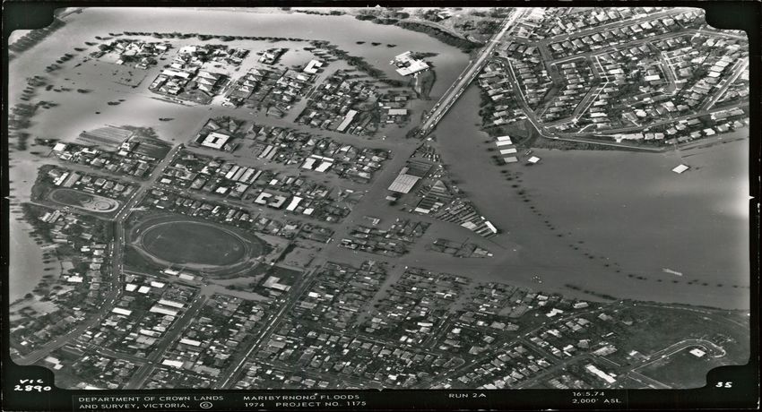
FLOOD INTEGRATED DECISION SUPPORT SYSTEM FOR MELBOURNE

Abstract

Melbourne Water (formerly the Melbourne and Metropolitan Boards of Works (MMBW)) is the
statutory drainage authority for metropolitan Melbourne. As part of this function, the business
collects real-time water resource data, performs floodplain mapping and modelling, maintains
waterways, and develops both structural flood mitigating works and non-structural flood
management options.

MMBW became involved in flood forecasting and warning following a severe riverine flood event in
May 1974 (see Figure 1). In September 1975 the MMWB began collection real-time data collection
of water level and rainfall, which enabled flood forecasting, flood warning and flood intelligence
such as flood maps.

Since 1975, MMBW and then Melbourne Water (MW) have made many improvements to its flood
forecasting and warning capability. The most recent is the creation of a Flood Integrated Decision
Support System (FIDSS) for the nine river systems that MW issues flood warnings, and ultimately
will include many of the small catchments which are susceptible to flash flooding.

FIDSS is being developed to integrate MW’s telemetry systems, URBS hydrologic models, and
flood maps with the latest Nowcast Products from the Bureau of Meteorology (BoM). The benefits
of this cutting edge system will be real-time flood predictions that will enable MW to raise faster,
more precise flood warnings via the BoM and FloodZoom, which will allow the State Emergency
Services and flood prone residents to take early action to mitigate the impacts of flooding.

In October 2014 the FIDSS Prototype was completed and the entire system will be operational in
the first half 2015. The presentation and paper will describe the evolution this state of the art total
flood warning system.

History - why is Melbourne Water involved in flood forecasting?

In 1970 the Supervising Engineer for Planning and Investigation of the Main Drainage Division of
the then Melbourne and Metropolitan Board of Works (MMBW) recommended that new
developments in telemetered data recording should be investigated for use in real-time flood
warning. The recommendation was approved in principle but it took a major flood in 1974 to
provide the necessary impetus for the project to be implemented. The winter flood of May 1974
was a major flood on the Maribyrnong and Lower Yarra River catchments following 120 mm of
rainfall over about three days, commencing on 13 May (Figure 1). The event caused the flooding
of over 500 properties and several million dollars damage. Following the event, the then Harmer
Liberal Government requested MMBW as the responsible drainage authority to - do something!
The State Government directed the MMBW to implement an automated flood warning system as
an immediate measure. This responsibility passed to Melbourne Water (MW) following the
reorganisation of MMBW.

The primary aim of the flood warning system was to gather data to enable flood predictions to be
made in sufficient time to:
• Prevent loss of life and reduce risk to the community and to;

2015 Floodplain Management Association National Conference                                           1
• Enable residents to relocate possessions and other items such as motor vehicles away from the
  area liable to flood. In this way, damage costs would be minimised and the socio-economic
  stress for the people on the floodplain would be lowered.

                         Figure 1: Flooding in the Maribyrnong in 1974

The Drainage Hydrology System

In September 1975 the Drainage Hydrology System (DHS) became operational. It ran on a DEC
Digital PDP 11/40 computer in conjunction with the Drainage Telemetry Network (DTN), initially
comprising 15 remote telemetered rainfall and river level gauges, using Telecom dedicated leased
line telephone communications established exclusively for flood warning requirements and
providing data every six minutes

At the time, the DHS was a state of the art data collection, monitoring and flood warning system
development with cutting edge solutions such as real time data collection, graphical visualization of
hydrographs, real time flood forecasting and text report flood inundation information.

When rainfall or stream levels and flows exceeded a threshold, alarms were activated by the
computer. Operations room staff would then inform the Senior Flood Warning staff of potential
flooding issues.

The DHS's primary aim was to gather sufficient data to enable accurate flood predictions to be
made and timely warnings to be disseminated on the larger waterways in Melbourne. The object
being to allow sufficient time to prevent loss of life, reduce risk and loss of valuables for the
community.

The DTN grew steadily from the original 15 sites installed as Stage 1, in 1975, with another 3
stages over the coming years.

2015 Floodplain Management Association National Conference                                         2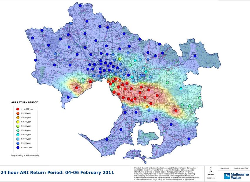
With the advancement in technology MMBW moved from the PDP 11/40 to a VAX/VMS cluster of
mainframe computers. A suite of drainage tools were then developed to run on the computer the
VAX/VMS computers. These were called the Drainage Application Suite. A few are described
below.

A program called Radar was also developed to display rainfall across the catchments. The
program interpolated between the rain gauges to show average catchment rainfall totals. This was
a very useful tool as operators could quickly see where rainfall was occurring and how much was
falling.

                                         Figure 2 – Radar

There were several other DHS programs within the system, which provided rainfall reports,
catchment summary reports and other outputs; too many to mention. Some utility programs were
also developed. An example is the Flood Inundation Program (FIP) which calculated flood levels
for specific residential addresses and provided the water level for the property and the floor (Figure
3). Having access to good survey data for specific flood prone areas enabled this tool to be a very
effective means of information to flood responders, especially State Emergency Services (SES).

2015 Floodplain Management Association National Conference                                          3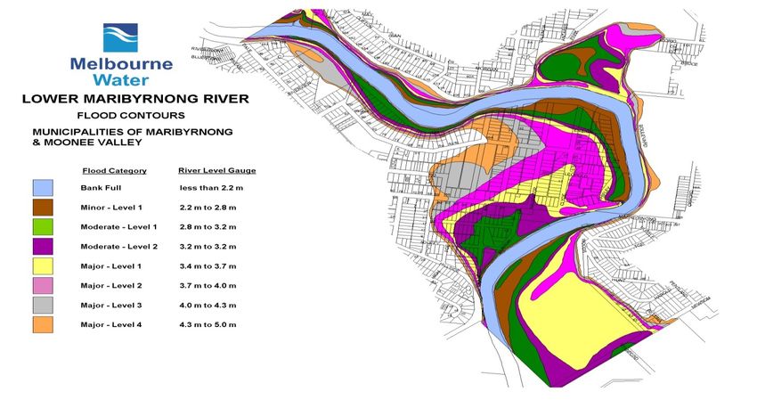
Figure 3 – Flood Inundation Program

In 1988 a very unique development proceeded and was completed in 1989. RTRORB or real-time
RORB was developed based on the RORB runoff routing software which was first developed in
1975 (then called RORT). RTRORB was developed in-house by MW engineers to perform in real-
time enabling flood forecasting based on observed rainfall and flows. Figure 4 shows an example
of the output of RTRORB.

                                    Figure 4 – RTRORB plot

2015 Floodplain Management Association National Conference                                   4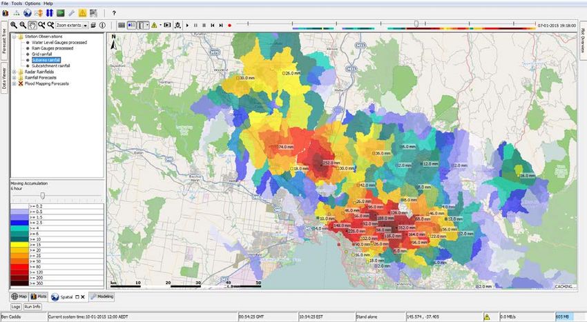
The program extracted real-time data (rainfall and river level/flow) from the DHS database and
prepared a data file that could be used with the RORB model to predict flood hydrograph at a
specified point on the stream of interest.

As a result of the DHS development, quantitative flood warning services were developed and
established for the larger waterways in Melbourne such as the Maribyrnong and Yarra River
catchments and for several other minor waterways.

RTRORB was replaced by the flood forecasting modelling software called Unified River Basin
Simulator (URBS) in 2006, which is still in use today.

Flood Forecasting Arrangements

The Victorian State Disaster Response Plan (DISPLAN) now called Emergency Management
Manual Victoria (EMMV) outlined that the MMBW had an obligation to “The Maintenance of an
organisation which, when flooding from natural causes is possible, monitor the Board’s telemetry
systems and provide advice to the Bureau of Meteorology”.

The current EMMV requires MW to:
• Continue to develop the flood monitoring system for our Waterway Management District.
• Provide flood predictions to the Bureau of Meteorology for Melbourne’s water courses for which
  flood warning systems have been developed.

Although the BoM is the Authority responsible for issuing flood warnings to the public, the MMBW
and then MW had all of the necessary instrumentation, systems and expertise for providing flood
forecasting in its area of operating jurisdiction.

In 1988 flood warning advice was provided by the MMBW officer in charge over the phone to the
BoM, and also as deemed necessary to the SES, some councils and Victoria Police.

Although MW still continue to have discussions with the BoM flood warning staff prior to potential
floods, a lot more automation of systems has been developed. MW flood forecasts are translated in
to flood warning templates and emailed to the BoM. The warnings have meteorological and SES
flood safety information added before they are sent out to SES, Local Government and media.

Flood Response

Flood Alert manuals were developed in 1983 and revised in 1988 to assist flood warning staff to
use the systems and follow the agreed processes for managing flood events.                 These
comprehensive manuals listed all of the steps that needed to be followed; they included flood
intelligence for each forecasting catchment, phone and fax numbers and hard copies of flood maps
where these were available (Figure 6 below).

2015 Floodplain Management Association National Conference                                      5
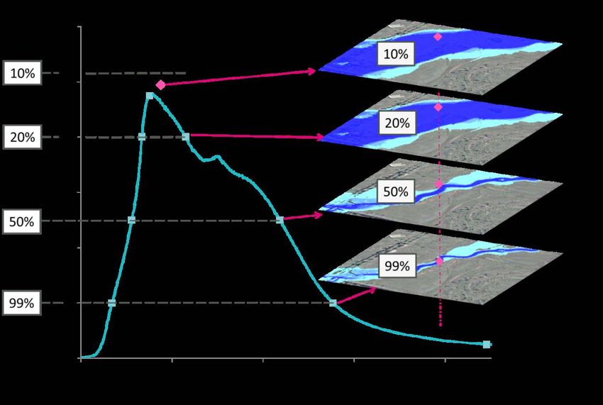
Figure 6 – Maribyrnong Floodplain flood class levels
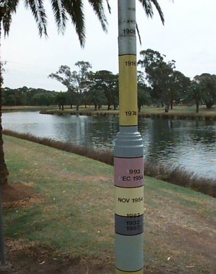
With good survey data and a very good history of flooding on the Maribyrnong floodplain, a flood
marker was established showing the previous years of flooding and their respective flood levels
(Figure 7)
Figure 7 – Historic Flood Pole
The levels were related back to each property on the floodplain, enabling resident specific flood
plans and awareness for each property owner of their flood risk. The Flood Preparedness of the
Maribyrnong Township is acknowledged as being one of the best examples anywhere in Australia.
More recently a Flood Warning Manual (FWM) was developed electronically as an html document
containing all information required by the flood forecasting team.
2015 Floodplain Management Association National Conference 6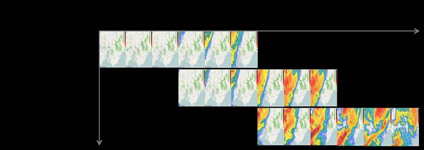
Floodplain Mapping

In the late 1990’s to early 2000’s MW undertook a huge project to flood map the urban areas of
Melbourne. The mapping project determined flood affected properties in Melbourne where
urbanisation had occurred prior to any planning controls. Flood maps were mainly created for the
1:100 year flood extent, and this data was then transferred to MapInfo GIS where it is still
frequently used today. From this, Special Building Overlays (SBO’s) were developed to assist with
assessing and planning for flood remediation projects, section 32 property statements and other
requirements.

Flood Warning Service

At MW the flood warning operations involves three separate levels of activity:

(a) Alert Phase

The Alert Phase involves the general awareness of catchment conditions from regular monitoring
of system summary reports. Contact is made with the Bureau of Meteorology to seek detailed
weather forecasts if potential flood conditions are identified. Pre-set rainfall, flow and fault alarms,
tidal and storm surge alarms, when triggered, are relayed directly to the Flood Warning team by
Melbourne Water’s Operations Room at Brooklyn or to South East Water during after-hours.

Pre-event planning may occur to ensure resourcing is available to respond to the event. Recent
changes have seen the inclusion of a Flood Watch to this phase. This is prepared for Melbourne by
the BoM in consultation with MW.

(b) Prediction Phase

The Prediction Phase mobilises staff to begin full-scale monitoring. Predictions are made for the
maximum flood level, timing of the flood, and where available, the number and location of
individual properties inundated. These predictions are regularly updated as more information
becomes available.

During this phase the duty officer regularly contacts the BoM and SES, keeping them informed of
possible flooding and obtaining updated weather forecasts.

(c) Warning Phase

Once the magnitude and timing of a flood has been predicted, the following procedures are
followed:

• MW prepares and issues a flood warning to the BoM. The BoM and MW agree on the wording
  of the warning before issue. A standard template was recently developed by the BoM which MW
  uses to prepare and send for issuing to SES.

2015 Floodplain Management Association National Conference                                            7
• The SES is advised of the flood predictions in areas likely to be inundated and residents in
  these areas are notified.

•   The flood is continuously monitored and the BOM and SES kept informed of flood progress and
    any changes in information.

•   MW’s Flood Response Plan (FRP) may be activated. MW has developed a FRP to manage the
    flood event. This is a comprehensive document that guides the flood incident response team
    through all phases of the flood event, including details of incident rooms, processes, resource
    contact details and other contingency information.

                                                                 Incident Initiation
           Flood Response Plan & Flood Warning Manual

                                                                MW Flood Alert System

                                                                  Incident Response
                      MW SCADA System

                                                                                                  Incident Training
                                                         Appoinment of Flood Response Team
                                                        Selection of Incident Management Centre
                                                                     Communications
                                                                       Co-ordination
                                                                       Engineering
                                                                          Welfare

                                                                   Incident Closure
                                                                   Post Flood Action
                                                                        Debrief

                                                             Figure 8 – Flood Response Process

Flood Education

The community on Maribyrnong River floodplain have been involved in flood education and
awareness for many years. In more recent times SES education and awareness called FloodSafe
and StormSafe has been released to the community.

In 2009 MW commenced a partnership with SES to assist development of Flood Management
Plans and Flood Emergency Plans, and expansion of community education and awareness to
flood affected areas. The partnership has recently been extended until 2019.

2015 Floodplain Management Association National Conference                                                            8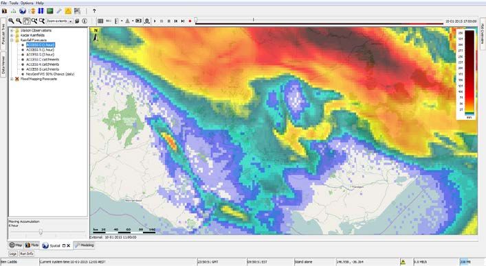
System Expansion and Changes

In 1987-88 the former Dandenong Valley Authority (DVA), also commenced development of a real-
time telemetry and flood warning system using Hydsys (now Hydstra). This system developed over
about 6 years. In 1995 this system was replaced with Event Reporting Radio Telemetry System
(ERRTS) and Prophet (data management software).

MW was formed during the mid-1990’s merging the MMBW, DVA and some other water authorites.
As part of the merger the hydrometric-flood warning system operated by the DVA was connected
to the DHS making it a substantial system, with some 250 monitoring locations.

In the late 1990’s to early 2000’s most of the remote telemetry devices were upgraded to ERRTS
devices. The project was undertaken to reduce the high operational costs, particularly associated
with the dedicated Telstra land lines, and to improve safety by eliminating the need for devices
using high purity nitrogen at the gauges. The $1M capital outlay was repaid in less than two years.

The DTN remained in place for about 25 years before the operating environment was replaced in
2000 with the Master Open System Architecture and Control (MOSAIC) SCADA system.

Flood Integrated Decision Support System Dream

A review of the DHS in the mid 2000’s found that MW had considerable high quality data,
floodplain mapping and modelling applications, yet this rich information was not integrated, and
during a flood incident response three or more separate systems were needed to be accessed.

At this time research into systems which provided an integrated system for flood forecasting,
warning and management of flood mapping commenced. The research project commenced in the
middle of Melbourne’s worst drought and it was difficult to justify funding a major upgrade to the
flood warning service.

In February 2011 one of the widest spread flood events in Melbourne history occurred as the
remnants of cyclone Yasi travelled down from Queensland (Figure 8). This event certainly signified
the end of the drought, if it had not already broken. It also prompted a project to enable integration
of disparate systems to enable better management of flood events.

2015 Floodplain Management Association National Conference                                          9
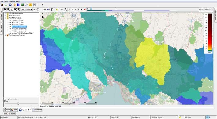
Figure 9 - Rainfall map

In 2014 MW commenced a tender process for an off-shelf solution which could be configured to
integrate flood forecasting, flood models and flood maps. The Deltares Flood Early Warning
System (FEWS) was selected as the best solution for MW’s needs.

FIDSS Overview

Complete total flood warning system

FIDSS is at the heart of MW’s Total Flood Warning System (TFWS); being an integrated decision
support system, it enables all the components of a TFWS to operate.

The Australian Emergency Management’s Flood Warning Manual 21, 2009 (the Manual) describes
a TFWS as a system made up of six of interdependent and linked components, that to be fully
effective must be present and operating appropriately. The components are shown in Figure 9.

2015 Floodplain Management Association National Conference                                10
Monitoring and                               Message                                     Protective
                   Interpretation                                   Communication                       Review
  Prediction                                Construction                                  Behaviour

                                       Communication and agency consultation and review

   Figure 10          Components of a TFWS (based on Australian Emergency Management’s
                                Flood Warning Manual 21, 2009)

These six components are defined in the Manual is and are show in in Table 1 below, together with
how they are achieved as part of the FIDSS project.

                                    Table 1: Flood Warning Components in FIDSS

        Flood Warning Manual 21                                How the component is realised
              Description                                             through FIDSS
Monitoring and prediction: detecting                       The FIDSS system incorporates key
environmental conditions that lead to                      Bureau of Meteorology weather prediction
flooding, and predicting river levels during               products as well as all MW’s rainfall and
the flood                                                  river level gauge data. These are
                                                           reviewed in FIDSS and warnings
                                                           generated if environmental conditions
                                                           indicate future flooding.
Interpretation: identifying in advance the                 FIDSS incorporates tailored flood extent
impacts of the predicted flood levels on                   maps for river gauge heights This gives
communities at risk                                        forecasters access to extents of flooding
                                                           for given predications of flows and levels.
                                                           These flood extents have been used by
                                                           MW and other agencies to develop
                                                           community           flood       preparedness
                                                           information and advice.
Message construction: devising the                         MW does not issue warnings directly to
content of the message which will warn                     the public, this is the responsibility of the
people of impending flooding                               BoM. MW does issue information to the
                                                           BoM to enable warnings to be issued to
                                                           the public and FIDSS will also provide
                                                           information to the Department of
                                                           Environment, Land, Water and Planning’s
                                                           (DEWLP’s) FloodZoom initiative which
                                                           will give a wide range of agencies and
                                                           particularly the SES access to reliable
                                                           information       to      activate     various
                                                           management           activities    such     as
                                                           evacuations or road closures
Communication: disseminating warning                       The FIDSS system has been built to
information in a timely fashion to people                  enable effective communication with the
and organisations likely to be affected by                 key agencies BoM and DELWP.
the flood

2015 Floodplain Management Association National Conference                                                       11
Flood Warning Manual 21 How the component is realised
Description through FIDSS
Protective behaviour: generating MW and the key agencies have worked
appropriate and timely actions and together to building appropriate plans
behaviours from the agencies involved based on given levels of flooding (minor,
and from the threatened community moderate, major) for the catchments for
which MW are responsible, and to
support individuals in flood prone areas to
prepare individual and community flood
plans.
Review: examining the various aspects The entire portion of the review process
of the system with a view to improving its cannot be incorporated into a software
performance application. However FIDSS enables
past events to be replayed to assess if
the right warnings were issued at the right
time based on the best available data,
and to determine the effectiveness of the
underlying predictive flow models,
compared to actual results.
For a flood warning system to work effectively, these components must all be present and they
must be integrated rather than operating in isolation from each other.
Incorporation of best available information
The FIDSS system has been configured to consume real time data from a variety of sources.
Having the latest information is vital for the prompt warning of flash floods where even a few
minutes notice can mean a substantial reduction in the consequences of flooding.
The latest information also enables the best hydrological modelling and incorporation of available
flood mapping products. In the future FIDSS could involve real time flood modelling based on a
FEWS-TUFLOW adapter that has recently been developed.
FIDSS Communications
Flood Warning is only useful if the tool enables effective communication.
FIDSS is designed to be able to communicate with the key agencies BoM who issue public flood
warnings and the Department of Environment, Land Water and Planning (DELWP’s) FloodZoom
system which will issue warnings to Victorian government agencies.
MW does not issue riverine warnings to the public however MW attracts a lot of public interest
during major storms. There are further opportunities to develop mobile phone applications for
crowd sourcing information, flash flood warning, improving flood investigations and web based
services and information such as online flood maps. MW’s website may receive 50,000 hits a day
during or after a storm event.
2015 Floodplain Management Association National Conference 12In developed areas of Melbourne where structural solutions are very costly and may take many years to deliver, or may not be feasible, FIDSS can assist residents through provision of timely information to direct to the stakeholders to reduce flood impacts. FIDSS will enable MW will supply BoM textural warnings as they have for many years, the quality and timeliness of these messages will be enhanced by the integration of a variety of data sources and the addition of new products such as Nowcast data that are incorporated into the URBS hydrological modelling. The data released to FloodZoom will include references to libraries of shared flood extents for the rivers which MW’s has responsibility for Flood Warning, together with snap shot graphical information on predicted rainfall in each catchment. FIDSS can also provide MW’s internal contractors with reports on predicted and actual rainfall totals and river flows to assist in programming and scheduling of works. How FIDSS works The FIDSS system has been created on Delft-FEWS, which is an open data handling platform that was initially developed as a hydrological forecasting and warning system in Netherlands. The Delft- FEWS application was developed at Deltares, an independent Dutch-based institute for applied research in the field of water, subsurface and infrastructure. Delft-FEWS is a sophisticated collection of modules designed for building hydrological forecasting systems and offers many options for the user to interact with the system. For a modern operational (forecasting) system this interaction is crucial. The FIDSS system uses many of the modules to deliver services to the flood forecasters at MW. Configuration and customisation The main focus of this section of the paper is on the configuration and customisation of Delft- FEWS to create the FIDSS solution. The development of FIDSS was contracted to BMT WBM and its partner Deltares. However the realisation of FIDSS required the input from a wide range of stakeholders including many departments inside MW, and a number of MW outsourced service providers, contractors and vendors, and most importantly the dedicated future system users. FIDSS also relies on the flood mapping developed by consultants over the last 20 years. FIDSS has also involved interaction with its customers most notably DELWP and BoM. The FIDSS solution has been created on a number of MW servers in various environments. The server set up is critical for the success of the project and the consumption of various external data sources to enable the critical integration aspects of FIDSS. This paper does not focus on the software or hardware architecture that supports the function of FIDSS, much of this is unique to MW overarching IT Environment. The development of solution was in two phases: 2015 Floodplain Management Association National Conference 13
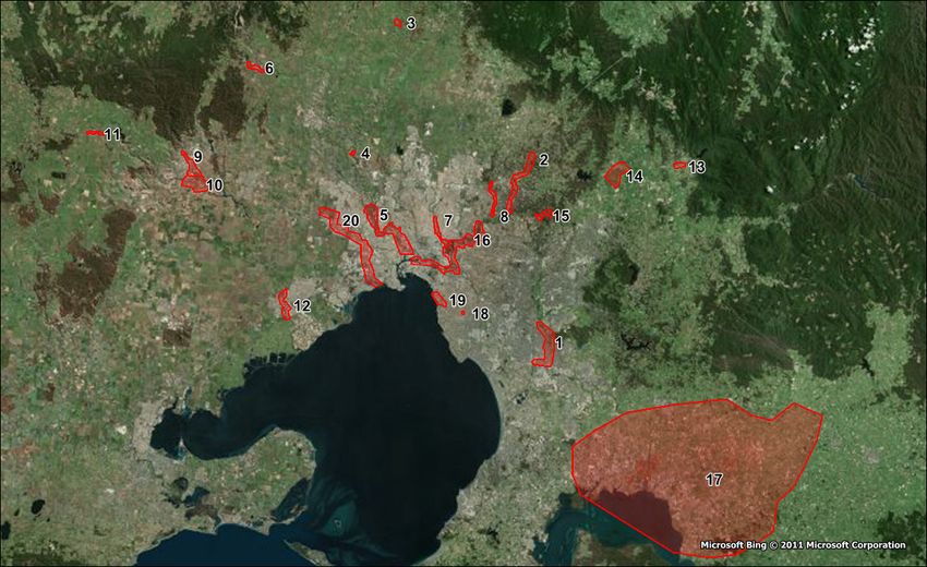
• Design and prototyping; and
• Implementation and testing.

The design and prototyping was an interactive development of the functional and business
requirements of MW, resulting in a design document which defined how many of the aspects of
FIDSS would be built and many of these features were incorporated into the prototypes. The first
phase of the project was delivered in a series of sprints, where by every few weeks an updated
product with increased functionality was demonstrated for one catchment Kororoit Creek.

The second phase continued to develop the prototype into a fully functional model and then
expanded into building out similar configurations for MW’s other watercourses.

Extent of the Flood Forecasting

FIDSS focuses on the catchments that MW has Flood Forecasting responsibility for these are:
• Bunyip
• Dandenong
• Kororoit
• Maribyrnong
• Werribee
• Yarra (and the main Yarra tributaries)

FIDSS incorporates the flood extent mapping that have been created over years for these
watercourses. MW’s more advanced 2D flood models have been reworked to provide improved
flood intelligence that could be integrated into FIDSS.

In addition to these catchments MW is also developing FIDSS to include a number of catchments
that are prone to flash flooding, including Gardiners Creek and Elster Creek.

MW is responsible for over 250 retarding basins across the metropolitan area and the first version
of FIDSS is trialling the incorporation of a critical retarding basin and its dam break effects, as well
as an early detection system at the site to detect potential outflow blockages.

FIDSS will also concentrate on 20 areas of interest. These areas are listed below and shown in
Figure 11.

2015 Floodplain Management Association National Conference                                           14
Figure 11     Melbourne Water Areas of Interest
The preliminary areas of interest are:
   1. Dandenong Ck d/s of Police Road RB
   2. Diamond Ck Hurstbridge to Yarra River
   3. Deep Creek at Darraweit Guim
   4. Deep Creek at Bulla
   5. Maribyrnong River Keilor Gauge to Footscray Road
   6. Jacksons Creek Rosslynne Reservoir to Calder Highw
   7. Merri Creek Bell St to Yarra River
   8. Plenty River Greensborough Gauge to Yarra River
   9. Lerderderg River u/s of Goodman Creek
   10. Werribee River at Bacchus Marsh
   11. Werribee River at Ballan
   12. Werribee River at Cottrell St Ford
   13. Watts River at Healesville
   14. Yarra River at Yarra Glen
   15. Yarra River at Warrandyte
   16. Yarra River d/s of Banksia St
   17. Bunyip River and Yallock Outfall
   18. Koornang Rd Main Drain at Cadby Avenue
   19. Elwood Canal / Elster Ck d/s of Asling St
   20. Kororoit Creek

FIDSS Key Components

The overall architecture of FIDSS is shown in Figure 12.

2015 Floodplain Management Association National Conference                    15
Figure 12     FIDSS Architecture

ERRTS Data – rain and river level stations throughout the catchments are transmitting data via a
VHF radio network, using the ALERT/IFLOWS protocols. These data are being collected using
ERRTS receivers and decoders, feeding a binary data stream into MOSAIC and HDE. There are
seven frequencies being used, resulting in 7 receivers and 4 decoders.

MOSAIC – the existing SCADA system used by the various divisions within MW is MOSAIC. For
all other users of MOSAIC data, the exchange of data occurs via HDE. For the flood forecasting
operations, data are directly outputted from MOSAIC via CSV file.

HDE – the Historic Data Exchange receives data and processes output data on to a defined folder
on the MW network. Various internal and external users pick up the HDE data from these folders.

Hydstra – the Hydstra database is a repository of data, including station metadata, rating curves
and IFD.

2015 Floodplain Management Association National Conference                                    16
Delft-FEWS – the core of the FIDSS system, where data are ingested and external models and
modules are controlled. Alerting output from Delft-FEWS is via e-mail.

Rating Conversion Utility - an Excel spreadsheet containing a macro for conversion of Hydstra
format rating curves into the Delft-FEWS compatible format.

Models – hydrologic and hydraulic models are automatically managed by Delft-FEWS, which pre-
processes data, executes the model, and post-processes model outputs for viewing within FIDSS.

Flood Mapping Utility – the utility extracts the flood extents mapping from the flood mapping
database for display in FIDSS.

Forecasts

FIDSS ingests rainfall forecasts provided by the BoM. Different forecasts can be displayed by
manually adjusting the system time so that the latest forecast applicable to that time is displayed.
These forecasts are saved as shown in Figure 13

                                Figure 13 Display of Forecasting

Forecasting Data
MW was one of the agency’s that funded the Smart Water project for the BoM to develop Nowcast
rainfall, although the project has finished BoM are continuing to provide this product via their
Registered User Service on subscription to Melbourne Water in NetCDF4 format.

MW is also accessing the following key BoM forecast products via the Registered User Service:
ACCESS-R12, ACCESS-C, ACCESS-G, and GFE. These forecast products, examples of which
are shown in Figure 14, 15 and 16 are used differently by FIDSS operators to forecast floods and
advise agencies during floods.

2015 Floodplain Management Association National Conference                                       17
Figure 14, ACCESS-C forecast
Figure 15, ACCESS-R forecast
Figure 16, ACCESS-G forecast
2015 Floodplain Management Association National Conference 18Table 2 is a summary of all the observation, Nowcast and forecast data ingested by FIDSS,
including source, method of transfer, frequency, resolution and format.
Table 2 Observation and forecast data scheduling
Description Observed / Source Method of Time Step Availability Forecast Spatial Format
forecast Transfer Period Resolution
Telemetry Observed MOSAIC File Every 1 - Every gauge CSV
/ HDE minute
QPE – bias Observed BoM FTP - BoM 6 minute Every 6 - 1km NetCDF4
corrected Registered minutes
radar User
Service
Blended rain Observed BoM BoM to 30 minute Every 30 - 1km NetCDF4
gauge and investigate minutes
radar data if available
Nowcast – 5 Forecast BoM FTP - BoM 10 minute 12 hours 2km NetCDF4
different Registered
ensembles User
Service
Access-R12, Forecast BoM FTP - BoM 3 hour Every 6 3.5 days varies NetCDF4
Access-C and Registered hours
Access-G User
Service
GFE (BoM’s Forecast BoM BoM to 3 hour Every 6 10 days NetCDF4
official investigate hours (forecasts
forecast) if available are most
accurate to 5
days)
These different products are processed inside FIDSS to enable a simple visualisation of average
rain over the various (sub) catchments. An example of the depth averaged rainfall based on the
one product, Access-C is shown in Figure 17.
Figure 17 Depth averaged rainfall over the catchments based on ACCESS C forecasts.
2015 Floodplain Management Association National Conference 19URBS Models
The forecasters at MW use the rainfall forecasts as inputs into hydrological models. Different
products are useful for different duration storms and different forecast times, the forecasts
therefore consider an ensemble of rainfall forecasts to generate flows.
Forecasters on their local machines run a number of forecasts through URBS to consider the
impact on flood flows. An example of an ensemble is shown in Figure 18; the ensemble is
composed of the following products:
• Observed gauge rainfall with ACCESS-C, G, and R NWP forecast
• Observed gauge rainfall with Nowcast forecast
• Rainfall Policy scenario forecast.
• Observed gauge rainfall with zero mm rainfall in the forecast period.
• Rainfall What-if Scenario forecast.
Figure 18 Ensemble run output in Plots display
HDE Data from Melbourne Water Gauges
The observed rainfall accumulations are routed to FIDSS every minute, rather than the historical
norm of every six minutes, this is because FIDSS can process the data efficiently and provide
reliable warnings for flash flood catchments where 1/10 hour is too great a time step, and
emergency services could miss out on precious minutes in a flash flood situation.
The accumulated rainfall can be gridded and then visualised with an open street maps background
and depth averaged for each subcatchments as in Figure 19.
2015 Floodplain Management Association National Conference 20Figure 19 Interpolation of observed rainfall for sub catchments Hydraulic models The outputs of numerous MW hydraulic models have been incorporated into FIDSS. These outputs have been related to peak heights at river gauging stations so that appropriate flood extents can be shown for various predicted and actual gauge levels. Some of the advanced 2D hydraulic models were modified to provide improved flood intelligence for the FIDSS model. Integration FIDSS works to integrate all the data, hydrology and hydraulics. This is demonstrated in the bespoke Flood Mapping Utility that uses a pre-defined library of flood surfaces corresponding to a Zone of Influence around each forecast location. Zones of Influence for each catchment are available in the GIS mapping layers associated with each catchment. Based on the level of the provisional forecast, the Flood Mapping Utility returns a peak flood extents grid representing the ‘next highest flood map’ for that location (Figure 20). 2015 Floodplain Management Association National Conference 21
Figure 20      Selection of peak flood map for provisional forecast

The Flood Mapping Utility also uses the time series of the simulated forecast to return a time series
of flood maps. The users are able to animate the flood extents in the time series mapping display (
Figure 21).

           Figure 21      Selection of time series flood maps for simulated forecast

2015 Floodplain Management Association National Conference                                        22
These time series maps provide considerable flood intelligence to be able to assess when various flood thresholds will be breached to allow SES and other agencies to plan evacuations and road closures more effectively than it has been possible to do in the past. Alerts and warnings FIDSS issues warnings and alerts by emails. Alerts are based on gauged river levels and, observed rainfall for a range of durations and intensities. These alerts have been developed to provide instantaneous information for internal MW staff and contractors to better manage their work and the safety of their crews. This information will be provided by email to a group within Melbourne Water. It will also potentially feed into future mobile apps. The development of FIDSS will also assist Melbourne Water to inform more than just its flood affected customers. The “Integrated” part of FIDSS will enable additional functions such as an ability to warn customers of high tides and of potential flash flooding. In addition to providing a TFWS for Melbourne Waterways Area the FIDSS project also provides a decision support system for low flow diversions. The combination of river gauge readings and weather forecasts and histories will enable effective decisions to be made with regard to the operation of flow diversions that operate on many of the MW river catchments Operational Usage of FIDSS As we approach the operational stage of FIDSS the number of potential uses are increasing beyond the core functionality and original business requirements. There is considerable untapped potential for FIDSS to be at the centre of all water course activities. Acknowledgements Geoff Crappers comments on the paper are much appreciated. References Emergency Management Australia, Australian emergency manual series, Part III Emergency management practice, Volume 3, Guidelines, Guide 6: Flood response, 1999. Waterways, Melbourne Water, Flood Response Plan, Version 6.8, 2014. Waterways, Melbourne Water, Flood warning manual, 2014. Flood Response Management in Melbourne Water 2015 Floodplain Management Association National Conference 23
You can also read


