Flood Risk Management Plans: (i) Mock up of a FRMP Scoping Report (ii) Mock up of a draft FRMP
←
→
Page content transcription
If your browser does not render page correctly, please read the page content below
Flood Risk Management Plans:
    (i) Mock up of a FRMP Scoping Report
    (ii) Mock up of a draft FRMP

August 2013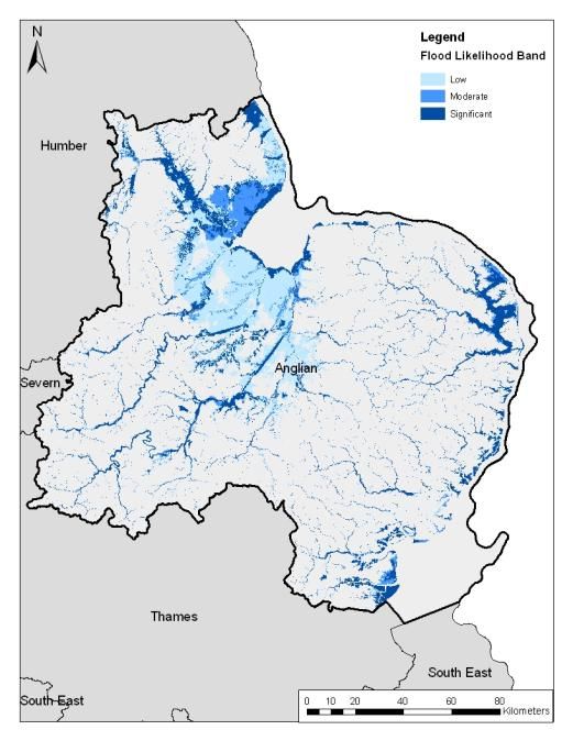
Flood Risk Management Plans:
  (i) Mock up of a FRMP Scoping Report

August 2013
Planning for floods: What’s being planned and when
     ALL THE INFORMATION IN THIS MOCK UP IS FOR ILLUSTRATION PURPOSES ONLY

Anglian River Basin District
Flood Risk Management Plan – Scoping document
December 2013

                    MOCK UP
  All information is for
  illustrative purposes
            only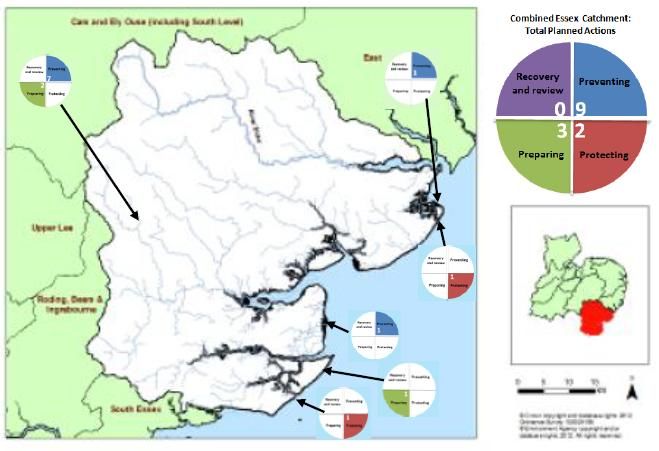
Foreword

Flooding is part of nature and something that we need to live with, but risk
management authorities can support communities and businesses to adapt to
flooding and become more resilient. A healthy water environment is also important
for wildlife and in supporting livelihoods. It is the role of the Environment Agency to
work with others to make sure the water environment is protected and improved.

Recently published information on flood hazard and flood risk means that
understanding of flood risk is improving. We and other risk management authorities
are in a good position to set out, with communities, how best to manage the risk of
flooding. Planning to manage flood risk is something that the Environment Agency
and Lead Local Flood Authorities are already doing but now we are setting out plans
for flood risk management across each river basin district. This document is not a
consultation, but it highlights the scope of those plans, in terms of what sources of
flooding are covered and when we intend to consult the public on those draft plans.

We hope that in understanding what plans are being developed, by whom and when,
you will be able to get involved in shaping those flood risk management plans, and
ultimately, develop a more resilient society and healthy environment.

Director, Anglian (Environment Agency)
Contents

Foreword .................................................................................................................... 4

1     Flooding matters to you ....................................................................................... 6

2     Supporting information ......................................................................................... 6

3     Planning for flood and coastal erosion risk management .................................... 7

4     What planning is happening now ......................................................................... 7

5     What that means for Anglian River Basin District ................................................ 8

    Overview ................................................................................................................. 8

    Sources of flood risk included in the FRMP for Anglian RBD ................................. 9

5     Strategic Environmental Assessment ................................................................ 11

    The purpose of strategic environmental assessment............................................ 11

    Providing a strategic context ................................................................................. 11

    Key environmental effects .................................................................................... 12

Annex 1. A summary of Local Flood Risk Management Strategies prepared by Lead
Local Flood Authorities ............................................................................................. 14

Annex 2. Policies, plans and programmes to be considered by the Strategic
Environmental Assessment ........................................................................................ 1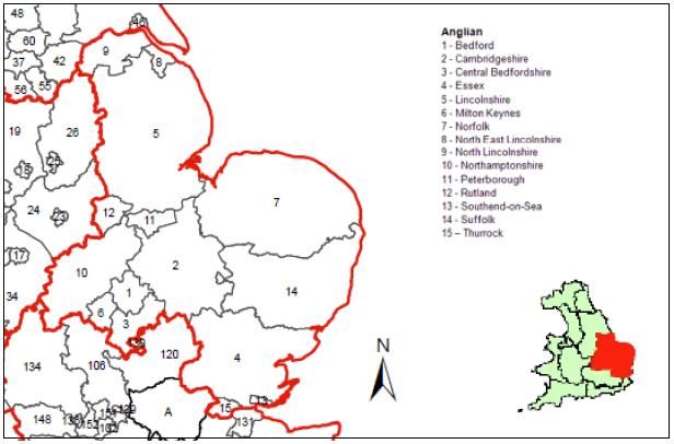
1      Flooding matters to you
Even if your home or business has not been flooded, you have an interest in flooding.
Flooding affects everyone because we all contribute in some way to the cost of managing
flood risk and we are all affected in some way by floods when they happen. The best way to
manage flood risk is by everyone being actively involved.

                         Box 1. The purpose of this document

    This document is not a consultation. It sets out what flood risk planning is going on
    across the Anglian river basin district, the timing of specific consultations, and which
    organisations lead on those consultation.

    By highlighting these consultations early on we hope that you will get involved in
    shaping the plans and be part of managing flooding.

    This document also sets out the level of detail of the environmental information that
    we aim to include in the environmental assessment that will accompany the flood
    risk management plan we prepare.

2      Supporting information
This document builds on other background information that you might find useful.

To find out more about legal requirements, in particular the Floods Directive and Flood Risk
Regulations please visit: Environment Agency web site.

To find out more about the roles and responsibilities of different flood risk management
authorities please visit: Defra website.

To find out more about our previous consultation on the approach developing Flood Risk
Management plans in England and Wales, and the findings from that consultation, please
visit: Environment Agency web site – consultation page

To find out more about flood risk where you live, please visit our web site at: WIYBY

                   Box 2. Co-ordinating with River Basin Planning

    The Environment Agency also leads on the development of River Basin
    Management Plans that set out how we and others plan to protect and improve the
    water environment.

    We aim to co-ordinate our work effectively, and support others to do the same, so
    that we can do more for the environment when we manage flooding.

    If you want to know more about River Basin Planning, or get involved, visit our web
    site: Environment Agency web site
3      Planning for flood and coastal erosion risk management
Planning for flood and coastal erosion risk management is evolving over time. There are
different types of plans, developed for different reasons, by different authorities. The table
below summarises the main plans and who leads on them.

Table 1 Flood and coastal erosion risk management plans in Anglian River Basin District

       Plan             Purpose and scope of                           Drivers                   Lead authority
                                plan
Flood Risk             To manage flooding from rivers,        Required under the              Lead Local Flood
                       the sea, reservoirs, surface water     European Floods Directive;      Authorities for flooding from
Management Plans
                       and groundwater.                       implemented in England by       surface water, groundwater
(FRMPs)                                                       the                             and ordinary watercourses.
Link to EA web site:                                          Flood Risk Regulations 2009
                                                                                              Environment Agency for
                                                                                              flooding form main rivers,
                                                                                              the sea and reservoirs.
Local Flood Risk       Sets out responsibilities for          Statutory requirement under     All Lead Local Flood
                       managing flooding in each Lead         the Flood and Water             Authorities must prepare a
Management
                       Local Flood Authority, objectives      Management Act 2010.            Local FRM Strategy.
Strategy               and measures for the
Link to Defra web      management of local flood risk         No statutory deadline for
site:                  (i.e. from surface water,              production.
                       groundwater and ordinary
                       watercourses).
Surface Water          To establish preferred approach to     Voluntary plans.                Likely to be Lead Local
                       managing surface water flooding.                                       Flood Authorities, in
Management Plans
                                                                                              partnership with others.
(SWMPs)
Link to Defra web
site:
Catchment Flood        Current and future inland flood risk   Voluntary plans.                Environment Agency
                       management across all                  Published in 2009-10
Management Plans
                       catchments.
(CFMPs)
Link to EA web site:
Shoreline              Current and future flood and           Voluntary plans.                Coastal Groups
                       coastal erosion risk management        Second round of SMPs
Management Plans
                       along the coastline.                   published in 2012-13
(SMPs)
Link to EA web site:
Estuary Strategies     Outline investment proposals for       Voluntary plans.                Operating authorities.
                       flood and coastal erosion risk
Link to EA web site:   management in estuaries.

4      What planning is happening now
The Floods Directive aims to provide a consistent approach to
managing flood risk across Europe. The Directive is implemented
through the Flood Risk Regulations and we are currently in the first
cycle of planning where some LLFAs need to prepare flood hazard
maps, flood risk maps and Flood Risk Management Plans (FRMPs)
that cover surface water flooding for the 10 Flood Risk Areas in
England and 8 in Wales (see adjacent figure). The Environment
Agency, and Natural Resources Wales need to prepare flood hazard
and risk maps, and FRMPs, for main rivers the sea and reservoirs
covering the whole of England and Wales.
                                                                                            Figure 1 Flood Risk Areas
FRMPs are important because they set out how risk management                                  in England and Wales
authorities and communities will work together to reduce the harm that flooding can cause.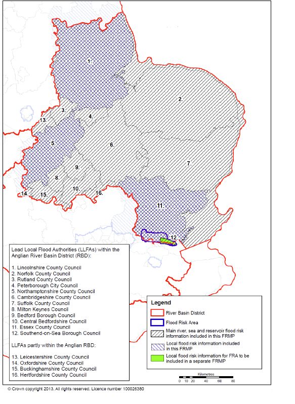
5      What that means for Anglian River Basin District
Overview
The legislation allows for separate FRMPs to be prepared by LLFAs for managing flooding
from surface water and the Environment Agency for managing flooding from main rivers the
sea and reservoirs. So, some LLFAs have decided to prepare separate FRMPs for surface
water while some LLFAs have chosen to pool information and prepare plans jointly with the
Environment Agency, so that they cover all sources of flooding.

In addition, while the legislation on requires FRMPs for surface water flooding to be prepared
for Flood Risk Areas, some LLFAs outside of Flood Risk Areas have chosen to voluntarily
pool information with the Environment Agency so that they can contribute fully to the
development of flood risk management plans that cover all sources of flood risk. Lead Local
Flood Authority areas are shown in Figure 2.

     Figure 3 Scope of Flood Risk Management Planning for Anglian River Basin District

     Figure 2 Lead Local Flood Authorities in Anglian River Basin District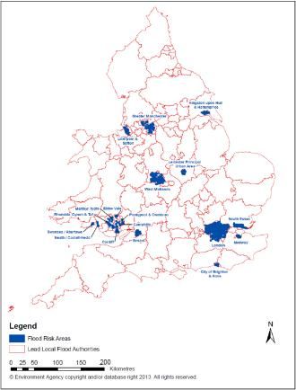
Sources of flood risk included in the FRMP for Anglian RBD
This section needs to be prepared following discussions between risk management authorities and
decisions by LLFAs on the approach they want to take to meet their statutory obligations under the
Flood Risk Regulations, and any voluntary contribution they want to make to the development of the
„all sources‟ FRMP – below is an example only.

For the Anglian RBD, the areas that will be covered by the „all sources‟ FRMP, and areas
where the FRMP will only cover particular sources of flooding are summarised in Box 3 and
Figure 3. Many Local Flood Risk Management Strategies are also being progressed by
LLFAs, and these are listed in Annex 1, along with the timescales when they are being
consulted on, so that anyone who wants to be involved in planning to manage flood risk
knows when plans are being prepared and consulted on, what they cover, and which
authority to contact.

In developing Flood Risk Management Plans we are also seeking to include information
about coastal erosion risk management that is set out within Shoreline Management Plans.
In this way, risk management authorities can share information about all sources of flooding
and coastal erosion risk management in one place, in a way that is more accessible to the
various authorities involved in planning, as well as interested communities and the public.

          Box 3. FRMPs in Anglian RBD being prepared and consulted on                           *
       For Anglian River Basin District, for the first cycle of planning under the Flood
       Risk Regulations, Risk Management Authorities will prepare the following plans
       and consult the public on draft plans during the dates set out below:

           -   Consultation from June 2014 to December 2014 on a draft single Flood
               Risk Management Plan that covers coastal erosion risk management for
               the whole coastline and all sources of flooding for the following areas:
                       - Essex County Council (as part of a Flood Risk Area),
                       - Lincolnshire County Council (as voluntary information),
                       - Northamptonshire County Council (as voluntary information).
               and also covers flooding from main rivers the sea and reservoirs for the
               rest of the river basin district.
       PLUS
          - Consultation from October 2014 to December 2014 on a separate draft
            Flood Risk Management Plan that covers only surface water flooding for
            the following area:
                       - Southend-on Sea Borough Council (as part of a Flood Risk Area)
       These areas and sources of flood risk are shown in Figure 2.

       *Note: this information is included for illustrative purposes only – as part of this mock up. It
       does not mean that any authorities have committed to prepare FRMPs using a particular
       approach.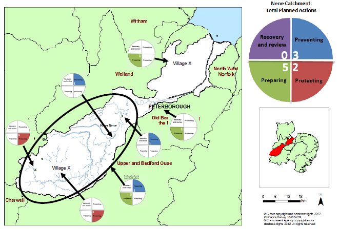
Figure 3 Scope of Flood Risk Management Planning for Anglian River Basin District
5 Strategic Environmental Assessment
The purpose of strategic environmental assessment
The primary purpose of a strategic environmental assessment (SEA) is to develop a plan
that delivers better environmental outcomes. By working alongside the development of the
plan, the assessment can prompt changes that reduce any negative environmental effects
and make the most of the benefits people receive from the environment.
The plan for managing flood and coastal erosion risk can have intended or unintended
consequences for people or the wider environment. These may be positive, for example by
improving recreational opportunities in an area; or may be negative, for example risk
harming historic features.
We will use the SEA to influence the development of the Flood Risk Management Plan to
make the most of positive outcomes that can arise from managing flood and coastal erosion
risk, and help to avoid or reduce the negative effects.
We want to focus on those effects that are significant. By significant we mean that they
would result in noticeable change (both positive and negative) to people‟s lives and the
environment. Further consideration will be given to the environmental effects of individual
actions arising from the plan at a local level before they are implemented. When planning
specific projects, there is greater scope to be more precise about the effects and the actions
required to mitigate or manage them.
Providing a strategic context
In preparing to manage flood and coastal erosion risk over the next six years there are a
range of other policies, plans and programmes that we need to consider. These include
those produced by the government, government agencies and local authorities. They could:
have a significant effect on flood and coastal erosion risk and therefore we might
need to think about how we adapt our plans
conflict with actions we want to include in the plan
inform us of key environmental issues that we should consider or provide additional
environmental information
help us to identify opportunities to take action that benefits the objectives of more
than one plan
help us to identify the potential cumulative effects of the plans
We have set out the plans that we consider to be relevant to the Anglian River Basin District
in Annex 2 to this document. We will be producing Environmental Reports to be published
with the draft Flood Risk Management Plans, that will provide a brief commentary of the key
issues arising from the plans, policies and programmes and how we have taken them into
account. [Note: LLFAs will need to indicate if they will be preparing Environmental Reports
for any separate FRMPs.]Key environmental effects
Water environments provide a range of benefits which the Flood Risk Management Plans
seek to protect and enhance, including economic, social and environmental benefits. There
is a strong link between these benefits and the environmental factors that we will address as
part of the SEA. Additionally, we will assess the significant effects on the wider environment.
The SEA Regulations set out a number of environmental factors to be considered during the
assessment. In our assessment we want to focus on those effects that are likely to be
significant, whether positive or negative. The following table sets out the environmental
issues referred to in the Regulations, indicates how these relate to the FRMPs and whether
we intend to address the issue as part of the SEA.
Where we propose to include an environmental effect in the assessment, the key issues
listed in the table are not intended to be a comprehensive list of possible impacts, but simply
to provide some justification for inclusion. In the text following Table 2, we have provided
some background on the current environment and indicated how the key environmental
effects more specifically apply to Anglian River Basin District.
The assessment will focus on those actions within the FRMP that result in „on the ground‟
activity such as, constructing / removing something, changes to land management or river
restoration. Other types of actions may be more focused on promoting changes in
behaviour of those that may be exposed to flood risk. Examples could be, education
campaigns, developing guidelines, etc. These are undoubtedly beneficial, but it is difficult to
assess, with any certainty, whether these are likely to result in significant environmental
effects. We therefore do not intend to consider these types of actions further in the
assessment. The Environmental Report will be clear on which actions have been assessed
and which effects are too uncertain to justify consideration.
Table 2: Scoping environmental effects for the SEA
Environmental Key effects to consider To be
topic addressed
by the SEA?
Biodiversity, flora and Effects on areas protected for their nature conservation value Yes
fauna (e.g. European Special Areas of Conservation and Special
Protection Areas, Ramsar sites and the nationally designated
Sites of Special Scientific Interest)
Effects on protected species and habitats associated with the
water environment
Effects on and of species introduced from outside of the UK that
are harmful to the environment
Effects on the wider protection and enhancement of biodiversity.
Population and Effects on the recreational use of water Yes
human health Effects on growth, regeneration and tourism
Improving access to water environments and the associated
health benefits
Effects on water abstracted for drinking water
Effects on water dependent industry, e.g. agriculture, energy and
ports.
Soil Effects of polluted land on the water environment Yes
Effects on areas of land vulnerable to erosion
Effects on nitrate vulnerable zones
Influences on how land is managedWater Effects on the habitats and the shape and flow of water bodies Yes
Effects on groundwater quality and quantity
Effects on bodies of water resulting from abstraction
Effects on the quality of coastal waters, including bathing waters
Effects on flood and coastal erosion risk management
Air While individual actions may have a small localised impact on air No
quality, at a strategic level, it very unlikely that the River Basin
Management Plan would have a significant effect on air quality within
the river basin district.
Climatic factors Climate change mitigation and adaptation Yes
Flood risk
Changes in greenhouse gas emissions relating to water
management
Infrastructure Effects on water related infrastructure such as canals, hydro Yes
power plants, flood defences, ports and harbours, etc.
Cultural heritage Effects on sites designated for their historic importance Yes
Effects on the wider historic environment associated with water
bodies.
Landscape Effects on landscapes designated for their quality Yes
Effects on wider landscape character and quality
Visual impacts on the landscape setting
Note: this list is for illustrative purposes only for this mock up
The Environmental Report, to be published with the draft FRMP, will provide information
about the environment. The Anglian River Basin District is relatively large and so, our
description will be at a strategic level.Annex 1. A summary of Local Flood Risk Management Strategies prepared by Lead Local Flood Authorities Note: LLFAs will also want to highlight the dates of consultation of any Environmental Reports prepared for the environmental assessment, as well as any Habitats Regulations Assessments and Appropriate Assessments undertaken for their Local FRMP Strategies.
Annex 2. Policies, plans and programmes to be considered
by the Strategic Environmental Assessment
Table A sets out the national plans, policies and programmes and Table B those that are only
relevant to the catchment or River Basin District. Rather than identify every possible plan or
programme we intend to focus on those that are likely to significantly influence the plan or our
consideration of the environmental effects.

Table A: National plans, policies and programmes to be considered in the SEA

Policy / Plan / Programme                                       Published by                     Year

Water white paper: Water for life                               Defra                            2011

Water for people and the environment: Water resources           Environment Agency               2009
strategy for England and Wales

National Planning Policy Framework                              Communities & local government   2012

Natural environment white paper: The natural choice: Securing   Defra                            2012
the value of nature

Biodiversity 2020: A strategy for England‟s Wildlife and        Defra                            2012
Ecosystem Services

Government Forestry & Woodlands Policy Statement                Defra                            2013

The invasive and non-native species framework strategy for      Defra, Scottish Government,      2008
Great Britain                                                   Welsh Assembly Government

Coastal squeeze: Implications for flood management. The         Defra                            2005
requirements of The European Birds and Habitats Directives.
Defra policy guidance.

Safeguarding our soils: A strategy for England                  Defra                            2009

Understanding the risks, empowering communities, building       Defra & Environment Agency       2011
resilience: The national flood and coastal erosion risk
management strategy for England

UK Marine Policy Statement                                      HMG, NI Executive, Scottish      2011
                                                                Government, Welsh Assembly
                                                                Government

National Policy Statements (Overarching Energy, Renewable       HMG                              2011-12
Energy, Fossil Fuels, Oil and Gas Supply and Storage,
Electricity Networks, Nuclear Power, Ports, Hazardous Waste,
Waste Water Treatment)

Managing the Environment in a Changing Climate                  Environment Agency               2010

The Government‟s Statement on the Historic Environment for      HMG                              2010
England 2010

All Landscapes Matter                                           Natural England                  2009
When identifying plans, policies and programmes relevant to the Anglian River Basin District,
we have concentrated on those plans that are similar in scale to the flood risk management plan
we are preparing for Anglian River Basin District, or that are likely to directly impact on the
catchments within the Anglian River Basin District. We anticipate that as plans and projects are
implemented the implications of any local plans will also be considered. There are some plans
that provide comprehensive coverage across the Anglian River Basin District, for example local
authority core strategies. Rather than list these individually we have identified the type of plan,
and when we undertake the assessment we will consider all of the plans of this type that are
relevant to the Anglian River Basin District.
Table B: Plans, policies and programmes relevant to the Anglian RBD
Policy / Plan / Programme Published by Year
Anglian Rivers Sea Trout Project: Phase 1 Report Anglian Sea Trout Project undated
partnership
Broads Plan Broads Authority 2011
The Chilterns AONB Management Plan 2008-2013 Chilterns Conservation Board 2008
Dedham Vale AONB and Stour Valley Management Plan Dedham Vale AONB and Stour 2010
2000-2015 Valley Joint Advisory Committee
Heritage at Risk 2012: East of England English Heritage 2012
Anglian Region Drought Plan Environment Agency 2012
Eel Management Plan: Anglian River Basin District Environment Agency 2009
Water resources strategy: Regional Action Plan for Anglian Environment Agency 2009
Region
Catchment Abstraction Management Plans Environment Agency Various
Anglian River Basin Management Plan (Draft) Environment Agency 2014
Catchment Flood Risk Management Plans Environment Agency Various
(Note: we will be drawing from these to develop the FRMPs)
Lincolnshire Wolds AONB Management Plan 2012-2017 Lincolnshire Wolds Countryside 2011
Service and
Lincolnshire Wolds Joint Advisory
Committee (AONB Partnership)
Core Strategies Local authorities Various
Minerals and Waste Plans Local authorities Various
Regional Transport Plans Local authorities Various
Surface Water Management Plans Local authorities Various
Water Cycle Strategies/Studies Local authorities Various
Developing Marine Plans for East Inshore, East Offshore and Marine Management Organisation Various
2South East Inshore
National Character Areas: Profile 46 The Fens Natural England 2013
National Character Areas: Profile 85 The Brecks Natural England 2012
Investing in the East of England's natural assets, state value Natural England 2009
and vision
Norfolk Coast AONB Management Plan 2009-2014 Norfolk Coast Partnership 2009
Final Draft Suffolk Coast and Heaths AONB Management Plan Suffolk and Coast Heaths AONB 2012
2013-2018 Partnership
Suffolk Coast and Heaths AONB Management Plan 2008- Suffolk and Coast Heaths AONB 2008
2013 Partnership
Coastal and Flood Risk Management Strategies, including Various Various
Local Flood Risk Management Strategies prepared by LLFAs
and Surface Water Management Plans
Local Biodiversity Action Plans Various Various
Shoreline Management Plans Various Various
(Note: we will be drawing from these to develop the FRMPs)
Water Level Management Plans Various Various
Drought Plan Water companies (Anglian Water, Various
Cambridge Water Company,
Essex and South Suffolk Water
and Affinity Water)
Water Resources Management Plan Water companies (Anglian Water, Various
Cambridge Water Company,
Essex and South Suffolk Water
and Affinity Water)
3Flood Risk Management Plans:
(ii) Mock up of a draft FRMP
August 2013
4Introduction to the mock FRMP
This mock up has been developed to prompt feedback on the format of the draft flood risk
management plan. It has been developed with support from:
- Anglian Water
- Essex County Council
- Lincolnshire County Council
- Northamptonshire County Council
Some thoughts from risk management authorities involved in this mock up
In working on this mock up, our partners have shared their thoughts on flood risk management
planning.
“Essex County encompasses a Flood Risk Area (South
Essex), so we must prepare a FRMP by December 2015.
We‟ve been working in partnership with other risk
“As part of working in partnership management authorities since becoming a Lead Local
with other risk management Flood Authority, so the opportunity to work on a plan for all
authorities across the area, we sources of flood risk makes sense in any case. Our Local
think it‟s important to highlight FRM Strategy has now been completed, and as our new
where we‟re contributing to team‟s understanding of surface water risk across the
managing flood risk”. County improves, we recognise the benefit of working with
other risk management authorities to develop a FRMP that
Anglian Water, July 2013
includes shared actions where mutual benefits and
priorities are identified”
Essex County Council, July 2013
“NCC have been provided with a great "The Lincolnshire Flood Risk and Drainage
opportunity to help develop and influence Management Partnership has collaboratively
the structure and content of Flood Risk produced a Joint Local Flood Risk and Drainage
Management Plan template. We very Management Strategy, which covers all sources of
much look forward to the continued flood risk. We look forward to developing our Flood
partnership working and in particular the Risk Management Plans on a similar basis, taking
opportunity to create an all-encompassing, account of new information such as the excellent
shared action plan between all partners work undertaken on the updated Flood Maps for
moving forward in the future”. Surface Water, to enable us to gain the best
understanding of the overall flood risk to our
Northamptonshire County Council, July 2013 communities and derive shared actions and
priorities."
Lincolnshire County Council, July 2013
5Planning for floods: What is being planned and
when
Planning for floods: What’s planned for your area
ALL THE INFORMATION IN THIS MOCK UP IS FOR ILLUSTRATION PURPOSES ONLY
Anglian River Basin District
Flood Risk Management Plan – Draft for consultation
June 2014
MOCK UP
All information is
for illustrative
purposes only
6We are risk management authorities. We work in partnership to reduce risk
the risks to people and properties from flooding.
We cannot do this alone. We work closely with others, including
government, business, other agencies, civil society groups and the
communities we serve.
7Welcome
This flood risk management plan sets out the proposed actions to manage flood risk in the
Anglian river basin district (RBD) from 2015 to 2021 and beyond. This plan should be read in
conjunction with the following:
- xxx FRMP for surface water flooding in XXX LLFA, scheduled for consultation from xx
data to xx date. List all FRMPs prepared separately for Flood Risk Areas and when
these are available for consultation (this will have been set out in the FRMP Scoping
document).
- The following Local Flood Risk Management Strategies:
List Local FRM Strategies in the Anglian RBD also being consulted on from June to
December 2014.
Risk Management Authorities (RMAs) work in partnership to reduce the risk of flooding. The
following RMAs have worked together across the Anglian River Basin District to develop this
Flood Risk Management Plan (FRMP):
- Anglian Water Company
- Environment Agency
- Essex County Council
- Lincolnshire County Council
- Northamptonshire County Council (who also contributes to the Humber FRMP)
- xxx County Council
- xxx District Council
- xxx Internal Drainage Board
- Etc. [list contributing organisation - alphabetised]
In preparing this FRMP we have considered flood and coastal erosion risk across the RBD and
set out how we, as individual organisations and partner risk management authorities, can work
with communities and others to manage flood risk from rivers (main rivers and ordinary
watercourses), the sea, reservoirs, surface water and groundwater. This plan also considers
coastal erosion risk management. The proposals within this FRMP are set out to share with
others so that they too can contribute to reducing risk, and help shape a more sustainable
future for communities and businesses, and the environment within which they thrive.
These proposals are subject to funding and we will monitor and report annually on progress in
implementing them. We will revise the proposals in the FRMP by 2021, ensuring that we can
maintain a forward look of prioritised proposals for managing flood risk.
We want your views by 22 December 2014 on the proposed plan and ask you to use the E-
consultation tool at the following website: xxxxxxxxxx.gov.uk.
8Contents
Welcome ......................................................................................................................... 8
What is the FRMP for? .............................................................................................. 11
Why are we preparing FRMPs? ................................................................................. 11
What flood risks are covered by the FRMP? ............................................................. 11
What the plan describes ............................................................................................ 12
How we have developed the plan ................................................................................. 14
The partnership.......................................................................................................... 15
How we have involved you ........................................................................................ 15
How we plan and set objectives ................................................................................ 15
Getting to know your River Basin District and the catchments ...................................... 16
Population and human health .................................................................................... 17
Infrastructure ............................................................................................................. 17
Landscape ................................................................................................................. 17
Biodiversity ................................................................................................................ 18
Cultural Heritage ........................................................................................................ 18
Soil............................................................................................................................. 19
Water ......................................................................................................................... 19
Climatic factors .......................................................................................................... 19
Key Flood Risk Issues ................................................................................................... 20
Key Statistics ............................................................................................................. 21
Actions to manage risk .................................................................................................. 22
On-going actions across the Anglian River Basin District .......................................... 24
Agreed actions across the Anglian River Basin District ............................................. 24
Planned actions across the Anglian River Basin District............................................ 25
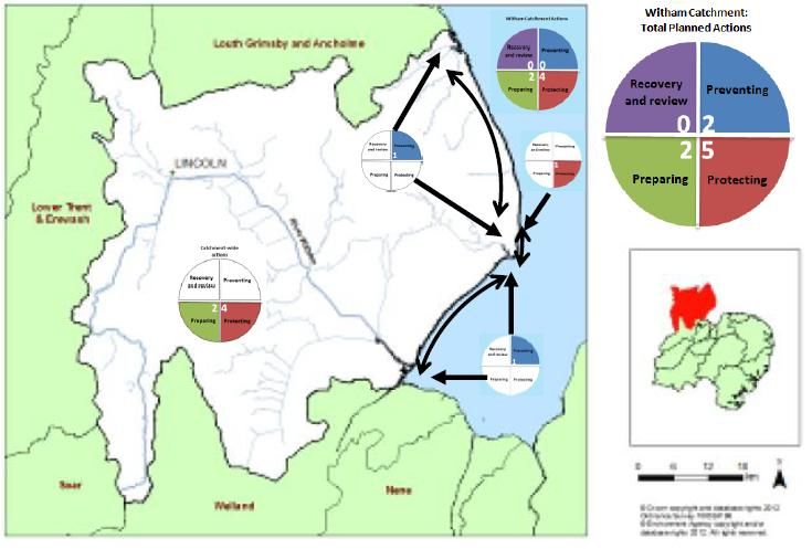
9The Combined Essex Catchment .................................................................................. 27
Summary ................................................................................................................... 27
Key Statistics ............................................................................................................. 27
Planned actions to manage risk ................................................................................. 28
Note: each catchment to be considered in turn
Implementing our plan ................................................................................................... 36
The Catchment based approach ................................................................................... 36
What happens next? ..................................................................................................... 36
Glossary ........................................................................................................................ 36
10What is a Flood Risk Management Plan?
[This should be two pages. Each paragraph should be brief]
What is the FRMP for?
Flood risk management planning is important because it sets out where and how to manage
flooding so that communities and the environment benefit the most. It‟s integral to the way risk
management authorities work and the new European legislation has formalised this.
Why are we preparing FRMPs?
The Flood Risk Regulations 2009 (the Regulations) implement the requirements of the Floods
Directive. They require some Lead Local Flood Authorities (LLFAs) and the Environment
Agency (EA) to prepare and publish Flood Risk Management
Plans (FRMPs) by December 2015. The Regulations set up a
six year cycle of assessing, mapping and developing plans to
manage flood risk.
We are currently in the first cycle of implementation where
Lead Local Flood Authorities are only required to prepare
FRMPs in Flood Risk Areas (Figure 1), where the risk of
flooding from local flood risks is significant (as described in
Government guidance). The Environment Agency is required
to prepare FRMPs for all of England covering flooding from
main rivers, the sea and reservoirs. The Environment Agency
is also required to co-ordinate the publishing of FRMPs for
each river basin district (the areas of England and Wales used Figure 1. Flood Risk Areas identified
for reporting to the European Commission). in the Preliminary Flood Risk
Assessment
What flood risks are covered by the FRMP?
While the Regulations only require those LLFAs in Flood Risk Areas to prepare FRMPs by
December 2015, other LLFAs have contributed to the FRMP voluntarily to help share proposals
about all sources of flood risk. Table 1 (Part A) lists the Flood Risk Areas identified in the
Anglian RBD, along with Lead Local Flood Authorities that have contributed to this FRMP.
Some LLFAs have prepared FRMPs that are presented as a separate document from this plan,
and these are also listed below (Part B). [delete if not applicable]
11Table 1. Flood Risk Areas in Anglian RBD and LLFAs contributing to this FRMP
Assessment
PART A: LLFA and Flood Risk Areas
included in this draft FRMP
Flood Risk Area Lead Local Flood Authorities
(or voluntary contribution from LLFA)
South Essex Flood Risk Area Essex County Council
Voluntary Contribution Lincolnshire County Council
Voluntary Contribution Northamptonshire County Council
Add LLFAs who have contributed to consolidated FRMP
PART B: LLFAs and Flood Risk Areas
included in separate draft FRMPs
Flood Risk Area Lead Local Flood Authorities
(or voluntary contribution from LLFA)
South Essex Flood Risk Area Southend-on-Sea*
* Note: Southend-on-Sea has been shown as preparing a separate FRMP for the purposes of this mock
up in order to demonstrate that LLFAs in Flood Risk Areas may chose to do so. This does not necessarily
represent how Southend-on-Sea will undertake its responsibility to prepare a FRMP under the Flood Risk
Regulations.
What the plan does
The FRMP sets out what needs to be done to mange flood risk. The FRMP draws from flood
hazard and flood risk maps published under the Flood Risk Regulations [LINK to maps when
published]. It summarises the risk of flooding from rivers, the sea and reservoirs across the
whole of the RBD, and from surface water flooding for the Lead Local Flood Authority areas
listed in Part A of Table 1 (see areas identified in Figure 2).
The FRMP draws relevant conclusions from these risks about problems or opportunities for
managing risk. Risk management objectives have been set out to steer the development of
appropriate actions that can help achieve those objectives, that is, what should be done to
manage risk. The various actions have been identified at the most appropriate scale, for
example, a particular community, or an rural area so that it is clear where the proposed actions
are and where they there may be potential benefits. These places have been set out within the
context of the catchments for this RBD.
Co-ordinating with river basin planning
In developing the draft FRMP, we have co-ordinated with the development of the draft River
Basin Management Plan by:
Set out the consideration of significant water management issues, and how FCRM contributes to these; how we
have taken account of the RBMP objectives in developing our FRMP objectives and how the actions we are
proposing contribute to achieving the objectives of the Water Framework Directive.
12Figure 2. Sources of Flood Risk included in this draft FRMP
13How we have developed the plan
In August 2012 the Environment Agency consulted on the approach to developing FRMPs.
They set out some options about the scale of the FRMP, the extent of integration or co-
ordination across the different sources of flood risk, the use of existing plan information, and
how best to co-ordinate consultation between plans covering different sources of flood risk as
well as with the River Basin Management Plan (prepared under the Water Framework
Directive).
In June 2013 Defra, Welsh Government, Natural Resources Wales and the Environment
Agency published the preferred approach to developing FRMP. This approach proposed the
Environment Agency to work in partnership with other RMA, in particular LLFAs, to pool
information to develop an overall plan for managing all sources of flood risk and coastal erosion.
(see Environment Agency website).
Therefore, in preparing this FRMP, the relevant information has been drawn from various
sources, as set out in Table 2. In drawing actions together, RMAs have revisit priorities and
ensured that there is a shared understanding of the outcomes we are aiming for and how we
can work most effectively to deliver those outcomes. Where a specific action has an establish
provenance (eg it is simply lifted from an existing SMP) this has been stated so that those
involved in the development of those proposals can see how their contribution has fed into this
FRMP.
Table 2. Sources of FRMP information according to source of flood risk
Source of flood risk Existing plans and source of FRMP
information
Flooding from main rivers Catchment Flood Management Plans:
Welland, Nene, Witham, Great Ouse, Broadland,
Essex, etc.
Flooding from the sea Shoreline Management Plans:
Flamborough Head to Gibraltar Point, Norfolk
Flooding along estuaries Estuary Management Plans
Xxx Management Plan
Flooding from Reservoirs Reservoir Plans:
XX Reservoir – On site Reservoir Plan
Flooding from surface water Local FRM Strategies:
Essex County Council Local FRM Strategy
Northamptonshire Local FRM Strategy
Lincolnshire Local FRM Strategy
Surface Water Management Plans:
XXX SWMP
Add to this table, as appropriate
14The partnership
Describe which partners have worked together on the FRMP
Consultation and engagement
How have we involved people in the process including any local road shows or focus
groups . Note: the final FRMP will need to include a record of consultation on the draft
FRMP.
How we plan and set objectives
The process that was followed how they reflect impact of human health, the
environment, cultural heritage and economic activity.
You can use the links below to find out more information about FRMPs and your
area.
Finding out more
Link to WIYBY (and flood hazard and risk maps)
Link to FRMP Consultation Summary Report
Link to FRMP web page
15Getting to know your River Basin District
and the catchments
Write a paragraph to introduce and describe the main feature and character of the River basin
district. Think about relating to what is important to people within the RBD. Text provided is for
illustrative purposes
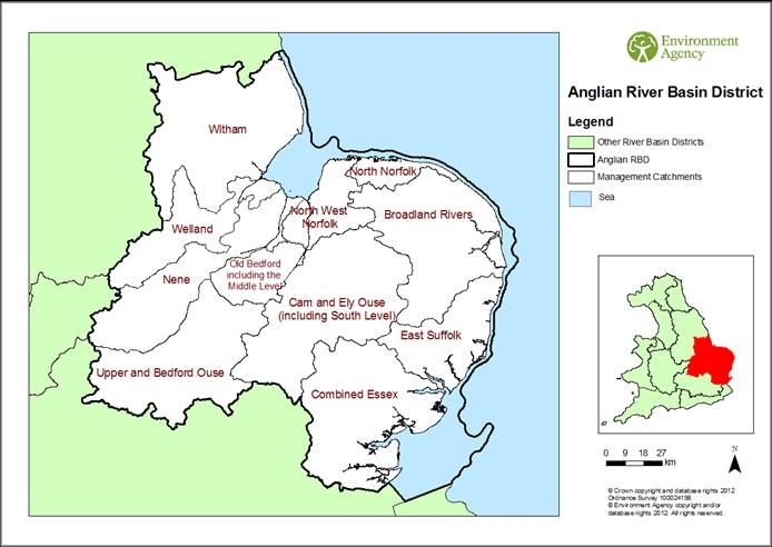
The Anglian River Basin District covers 27,890 km2 from Lincolnshire in the north to Essex in
the south, and Northamptonshire in the west to the East Anglian coast. The river basin district
comprises eleven catchments (Figure 3) which include different types of water bodies such as
rivers, lakes, coastal and transitional (estuarine) waters as well as groundwater. The
catchments vary: some are in a more natural state, while others have been significantly altered
by man, for example, to reduce the risk of flooding from rivers and the sea, and to drain the land
for agriculture.
Figure 3. Catchments within Anglian River Basin District
16Population and human health
The river basin district is predominantly rural, with more than half of its land used for agriculture
and horticulture. This has led to physical changes to the water environment and pollution from
agricultural runoff (see the draft River Basin Management Plan). This is particularly evident in
the Lincolnshire and Cambridgeshire Fens (which fall across six of the eleven catchments).
Tree cover is approximately 7% of the river basin district, with Thetford Forest in the Cam and
Ely Ouse catchment being the largest forest covering 20,000ha.
Over 7.1 million people live and work in small or medium sized towns and cities within the river
basin district. The water environment within urban areas has been physically altered to allow for
development and water supply. Many of the towns are proposing significant housing growth,
along with the creation of jobs and services. In particular, the Nene catchment is the largest
growth area outside of London. Many of the industries are water dependent, for example,
agriculture, horticulture, commercial fishing, power generation and manufacturing.
The current population in most communities in Norfolk, Suffolk and Cambridgeshire is healthier
and lives longer than the national average, and this trend is expected to continue. However in
some communities there are widening health inequalities. Some waterside locations are areas
of deprivation that result from industrial decline or neglect. Improvements to these areas and
regeneration initiatives can have multiple benefits, including; improving the environment and
quality of life; providing employment and other potential economic benefits.
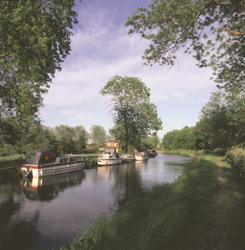
The Anglian River Basin District offers some outstanding recreational opportunities which
contribute to people‟s quality of life and bring economic benefit from tourism. Some examples
include the Norfolk Broads within the Broadlands catchment, seaside towns and wildlife in the
coastal catchments, Grafham Water and the Grand Union Canal in the Upper Ouse and
Bedford Ouse catchment, Rutland Water within the Welland catchment, and numerous other
opportunities for angling and boating.
Infrastructure
Infrastructure in the river basin district may affect the water environment, for example, through
the dredging of the river channel required to enable navigation to ports. It may also be affected
by the way the water environment is managed, for example, through the way flood risk is
managed for infrastructure. Infrastructure within the river basin district include railways (such as
the East Coast Main Line Railway), motorways, primary roads, power stations including
Sizewell nuclear power station (within the East Suffolk catchment), hydropower, airports
(including Royal Air-force and US Airforce bases), canals, marinas and ports. The river basin
district has approximately 1,300 licensed waste sites, and 2000 historic landfill sites, many of
which lie in close proximity to water bodies.
Landscape
The landscape in the river basin district ranges from gentle chalk and limestone ridges to the
extensive lowlands of the Fens and East Anglian coastal estuaries and marshes. There are five
Areas of Outstanding Natural Beauty (Lincolnshire Wolds, Norfolk Coast, Suffolk Coast and
Heath, the Chilterns and Dedham Vale) and The Broads National Park. There are two heritage
coasts in the river basin district (North Norfolk and Suffolk). These areas attract large numbers
of tourists each year, providing an important contribution to the economy. The water
17environment within some of these designated areas, for example, The Broads National Park, is
fundamental to the character of the landscape.
Biodiversity
The river basin district is the richest region in the UK for wetland wildlife and there is an
extensive and varied coastline which includes 33% of the UK‟s saltmarsh habitat. The
importance of this habitat is reflected by a variety of international, national and local nature
conservation designations. The international designations comprise; 24 Special Areas of
Conservation (SACs), 22 Special Protection Areas (SPAs) and 25 Ramsar sites are water
related. There are five recommended Marine Conservation Zones (Lincs Belt, Cromer Shoal
Chalk Beds, Alde Ore Estuary, Stour and Orwell Estuary, and Blackwater, Crouch , Roach and
Colne Estuary) that fall within or adjacent to the river basin district. Of the five recommended,
the Stour and Orwell Estuary and the Blackwater, Crouch, Roach and Colne Estuary are
recommended for designation in 2013. There are approximately 678 Sites of Special Scientific
Interest (SSSIs) and 55 National Nature Reserves (NNRs). Towards the east, where much of
the land is flat and low lying, many of the SSSIs have close links with the water environment.
The majority of SSSIs in the river basin district are in favourable condition, with abstraction,
general water shortage, and flooding and coastal erosion considered to be the key threats to
the condition of these SSSIs.
Water bodies and wetland areas within the river basin district support a number of protected
species (such as otters and water voles) and priority species listed in the UK Biodiversity Action
Plan (such as freshwater white-clawed crayfish and bittern). Invasive species are present in
over half of the water bodies across the river basin district, such as the signal crayfish. These
species may be affected by the way we manage the water environment.
The coastal areas of the Anglian River Basin District are covered by two marine plan areas
(East Inshore and South East Inshore). Further offshore, there is also the East Offshore marine
plan area. The marine plans are currently being developed by the Marine Management
Organisation. They will inform and guide marine users and regulators across England,
managing the sustainable development of marine industries, such as wind farms and fishing,
alongside the need to conserve and protect marine species and habitats.
Cultural Heritage
Cultural heritage has a high profile in the river basin district with approximately 2,500 Scheduled
Ancient Monuments (SAMs), and numerous Registered Parks and Gardens, listed buildings
and heritage sites. The majority of listed buildings in the river basin district are within built up
areas. Where these areas are low lying and where the town was developed either as a trade
centre, because of its canal or river links to the sea, or as a port adjacent to the sea, listed
buildings may be vulnerable to both river and tidal flooding. Many structures such as mills,
bridges, weirs and sluices directly associated with the water environment have listed status or
are of local historic importance.
The river basin district is rich in archaeology; this is particularly true in the fens, where the peat
has preserved organic material, which has largely disappeared from drier parts. There are large
areas of land where we have little or no knowledge of what might lie beneath the topsoil and in
certain places, such as along the River Witham (Witham catchment), well-preserved
archaeological remains are believed to be present.
18Soil
The bedrock geology of the river basin district is characterised by sandstone, mudstone and
limestone. The surface, or drift geology features peat, clays, sands, silts and gravels laid over
the bedrock in some places, whilst in others, the bedrock remains exposed or lies directly
beneath the soil. A band of chalk runs diagonally across the river basin district into the North
Norfolk catchment whilst around the Wash are areas of silt and clay. Within the river basin
district, there are a number of SSSIs that are designated for geological reasons, for example,
Gibraltar Point in Lincolnshire and Adventurer‟s Land in Cambridgeshire
Minerals extraction is an important industry across the river basin district, and a number of
former extraction sites have been turned into reservoirs or recreational water bodies, or have
been used as landfills. Surface quarrying is particularly important in the Upper Ouse and
Bedford Ouse catchment.
Water
The groundwater and surface water bodies are subject to high levels of abstraction, mainly for
public water supplies and agriculture . In particular, the Nene and Welland catchments provide
water to Rutland Water, the Upper Ouse and Bedford Ouse catchment provide water to
Grafham Water, and the Cam and Ely Ouse catchment provides water supplies both within the
catchment and to Essex and Suffolk via the Ely Ouse to Essex transfer scheme. Abstraction
can cause damage to the water environment through a reduction in water flow and less dilution
of contaminants (see the draft River Basin Management Plan).
Climatic factors
According to UKCIP, by the 2020s, temperatures across the river basin district could rise by up
to 3°C under a low or high emissions scenario (50% probability level). Summer rainfall may
decrease by up to 20% under either scenario, and winter rainfall may increase by up to 20%
under either scenario. These extremes impact on water related issues such as decreased water
availability and an increase people and properties being at risk from the affects of flooding.
19ALL THE INFORMATION IN THIS DOCUMENT IS FOR ILLUSTRATION PURPOSES
ONLY
Key Flood Risk Issues
Include key message about the RBD, could include links to RBMP, WFD measure and
environment here:
Map of flooding from rivers and the sea: Map of flooding from surface water:
INSERT MAP
EXAMPLE ONLY EXAMPLE ONLY
THESE ARE NOT THE PROPOSED THESE ARE NOT THE PROPOSED
FLOOD HAZARD MAPS FLOOD HAZARD MAPS
Map of flooding from reservoirs:
EXAMPLE ONLY
THESE ARE NOT THE PROPOSED
FLOOD HAZARD MAPS
INSERT MAP
20Figure. X. Summary chart of flooding across the Anglian catchments.
3500
Numbers of properties flooding in a
1% annual probability flood 3000 Surface water
2500 Sea
Tidal flows
2000
Rivers
1500
1000
500
0
Key Statistics
Include a summary table of infrastructure and assets at risk from flooding
Finding out more
Link to WIYBY
Link to draft River Basin Management Plan
21Actions to manage risk
There are different approaches to managing flood and coastal erosion risk depending on the
probability and consequences, as well as the technical natural of the risk. We use the following
terminology:
Preventing risk: for example, by not building homes in areas that can be flooded we can
prevent risks from arising in the first instance.
Preparing for risk: for example, by improving awareness of flood risk, or by providing
warning and forecasting for floods, people can take precautions to safeguard their
valuables.
Protecting from risk: for example, by using water proof boards over doors and airbricks
people can protect their properties from the damages of flood water.
Recovery and review of risk: for example, by improving access to tradesman and other
services, recovery after flooding can be improved.
To manage flood and coastal erosion risk effectively it take a single measures, or a combination
of measures, and this depends on many factors, including the complexity of the risk, what‟s at
risk, as well as the cost of the measures. All these factors need to be considered before
measures can be implemented effectively.
E.g. supporting recovery
after flooding has
happened and reviewing
how things can be better
in the future
E.g. Land use and
development policy to
manage risk, or relocation
of assets at risk, or
measures to divert the
E.g. preparing for a flood hazard to avoid harm
to happen so that we can
respond in a way that
mitigates the risk (eg, E.g. Prevent flooding from
forecasting, warning, damaging the things we
awareness and having care about by protecting
emergency plans that set them, such as property-
out what to do if it floods) level protection and flood
defences.
22This plan sets out the type of measures proposed to manage the risk we currently know about.
In developing the proposed measures we have:
Set out the thinking behind developing the actions:
- drawn conclusions from hazard and risk maps: this helps us all to understand the
problem or opportunities we are aiming to manage;
- developed risk management objectives (related to people and society, the
environment and economy): that set out the outcomes are we trying to achieve; and
- identified the likely approach to managing risk: using the categories listed above:
preventing, preparing, protecting and recovering and review.
There are already many actions underway to manage flood and coastal erosion risk. These are
on-going actions and we are not seeking views on these on-going actions. Over time, some on-
going actions may need to change, for example, an established maintenance regime may need
to change, perhaps because it is too costly, or new technology offers opportunities to do things
differently. In these instances, we would want to work with communities to develop new ways of
managing risk and we would do this through planned actions.
There are also actions that are proposed (and likely to be funded over the coming years). These
actions are considered agreed and we are not seeking views on these agreed actions.
The planned actions are those that we think should be progressed from 2015 onwards and
these are the actions we want your views on. So, we have a “pipeline” of proposals, and the
planned actions in this FRMP are those that we want your views on.
Planned actions: are Agreed actions: are On-going actions:
what we think should already agreed and are are already being
be progressed – these likely to be funded – we done – we are not
are the actions we are not seeking views seeking views on
want your views on on these these
We want your views
Add specific question you seek view son (e.g. the areas where actions are
proposed, the balance between different approach etc?
23On-going actions across the Anglian River Basin District
Across Anglian RBD the on-going actions to manage flood risk include (include maps where
appropriate):
Preventing risk: Summarise the relevant measures already in place to prevent flood and
coastal erosion risk. Eg. National Planning Framework; other planning policies by
planning authorities. On-going maintenance programmes is included in this category, so
link to maintenance programmes on website.
Preparing for risk: Summarise the relevant measures already in place to prepare for risk.
Anglian RBD has XX flood warning areas (include map); and xx Multi-Agency Flood
Plans, etc.
Protecting from risk: Summarise the relevant measures already in place to protect from
risk. Summarise the assets (e.g. from asset registers) and the scale of protection
afforded (eg broad numbers of properties benefiting etc); the scale of property-level
protection implemented etc.
Recovery and review of risk: Summarise the relevant measures already in place to
prepare for risk. E.g. community recovery plans, etc.
Agreed actions across the Anglian River Basin District
Across Anglian RBD the agreed actions to manage flood risk include (include maps where
appropriate):
Preventing risk: Summarise the relevant measures that are agreed to prevent flood and
coastal erosion risk. Eg. new policies, new modelling and assessment work that will be
undertaken etc.
Preparing for risk: Summarise the the relevant measures that are agreed to prepare for
risk. Anglian RBD has XX agreed new flood warning areas (include map).
Protecting from risk: Summarise the the relevant measures agreed to protect from risk.
Summarise the proposed measures (link to the medium term plan) and the scale of
protection afforded (eg broad numbers of properties benefiting etc); the scale of
property-level protection proposed etc.
Recovery and review of risk: Summarise the the relevant measures agreed to prepare
for risk. E.g. community recovery plans, etc.
24You can also read