Geologia Marina - Moodle@Units
←
→
Page content transcription
If your browser does not render page correctly, please read the page content below
Geologia Marina 2019/2020

          Università di Trieste
 LAUREA MAGISTRALE IN GEOSCIENZE
         Curriculum Geofisico
   Curriculum Geologico Ambientale

    Anno accademico 2019 – 2020

     Geologia Marina

PARTE 5 - GEOLOGIA MARINA REGIONALE

   Modulo 5.3 Mari Italiani – Adriatico

                 Docente
             Valentina Volpi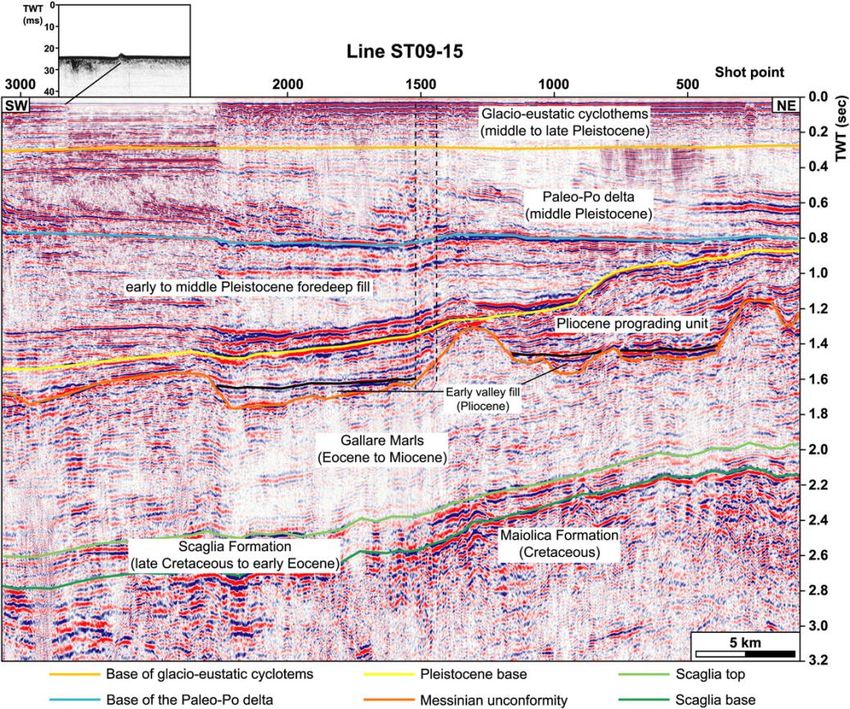
Geologia Marina 2019/2020
                                                                    2018/2019

                        General features and Morphology

                                                                       Surface ~ 140 km2
                                                                        Length > 150 m

                                                                        Depth
                                                                        north: up to 75 m
                                                                        centre: over 200 m (Fossa del Pomo)
                                                                        south: max 1223 m

                                           Coast
The coasts have a rocky character, with marly-arenaceous formations and prevailing limestones at
the promontories of Conero, Gargano and Salento. The northwestern and Albanian coasts are
generally low with the presence of lagoon; these are areas where the river contribution is high (e.g.
Po Delta)., while it is not so for karstic areas. The eastern coasts are particularly complex with a lot
of islands (i.e. Croatia, Dalmatia).
                                                                          Istituto Nazionale
                                                                          di Oceanografia e di Geofisica Sperimentale   2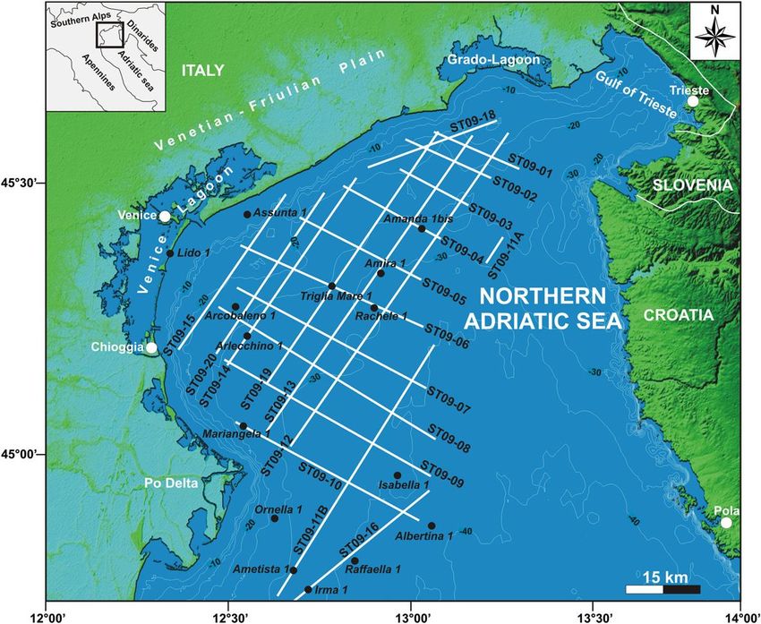
Geologia Marina 2019/2020
                                 2018/2019

ADRIATIC REGION and ADRIA PLATE

                                   (Viti et al., 2006)

                                    Istituto Nazionale
                                                                             3
                                    di Oceanografia e di Geofisica Sperimentale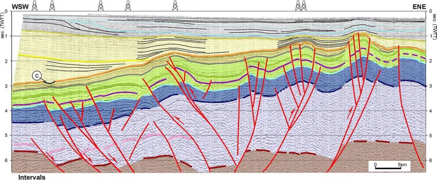
Geologia Marina 2019/2020

              Evolution of the Adriatic area
                  Late Paleozoic – early Mesozoic (330-250 Ma)

                         LAURASIA

                               GONDWANA

A single super continent will be the prologue of the geological history of the
planet. Right along the line of separation of Pangea, began the story of future
Italy. It is here where Adria, a promontory of North Africa, occupied entirely by
Tetide, will be the origin of the Mediterranean and the Italian peninsula.

                                                              Istituto Nazionale
                                                              di Oceanografia e di Geofisica Sperimentale   4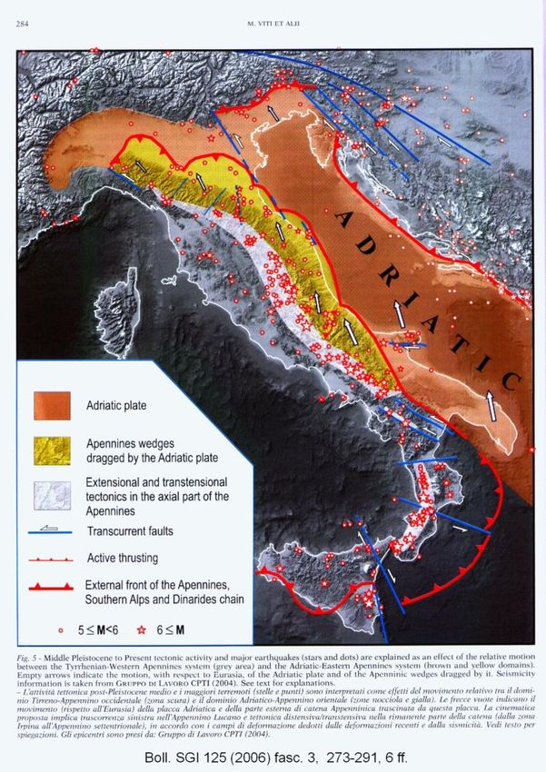
Geologia Marina 2019/2020

                    Evolution of the Adriatic area
                     Late Paleozoic – Early Mesozoic (330-250 Ma)

Italy, or rather what will become our territory, was on Adria plate and on its margins, in contact with the
African and European plates. It was covered by an epicontinental shallow sea, surrounded by low coastal plains
periodically invaded by tides. You can see the profiles of Sicily, and of Sardo-Corso block highlighted in green.
The only areas emerged, with arid plains and dryed reliefs, were a small part of Tuscany and Sardinia that was
on the coast of the European continent; the rest of the area were occupied by reefs and coral atolls, tidal
plains, brackish swamps.

                                                                              Istituto Nazionale
                                                                              di Oceanografia e di Geofisica Sperimentale   5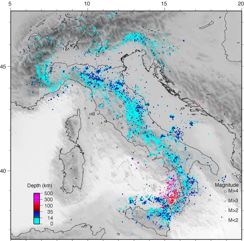
Geologia Marina 2019/2020

                    Evolution of the Adriatic area
                                      Late Jurassic (150 Ma)

The separation that at the end of the Triassic period affected the center of Pangea widened more and more
until, in the Middle Jurassic 180-160 Ma, America separates itself from Africa: the Central Atlantic Ocean is
born.
This phenomenon had an important consequence on the Mediterranean area: Africa and Europe began to
separate and the Ligurian-Piedmontese Ocean was created in the middle. Thus, two new continental margins
were born, separated by the newborn Ligurian-Piemontese Ocean: the Adria to the east and the European
coast to the west.
                                                                             Istituto Nazionale
                                                                             di Oceanografia e di Geofisica Sperimentale   6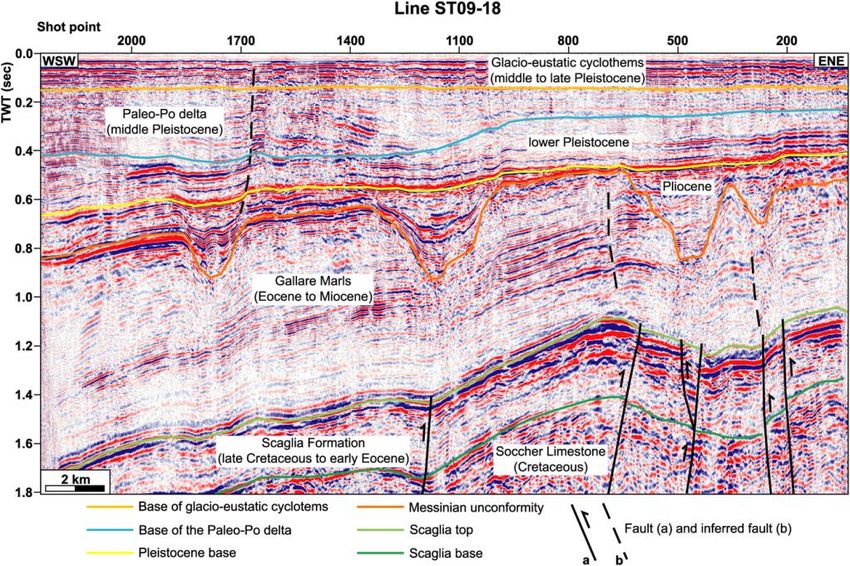
Geologia Marina 2019/2020

                       Evolution of the Adriatic area
                            Late Mesozoico – Early Cenozoic (65 Ma)
                                 Africa                   Origin of Alps
                       Eurasia
                                                   The rocks that formed the basement of the Tethys
In seguito alla deriva dei continenti, la placca   underwent a slow but continuous compression that
africana cominciò a spingere su quella             emerged from the water of the ocean and gave rise to the
euroasiatica, fratturando il fondale dell'antica   system of thrust sheets and folds of the Alpine chain and
Tètide e contribuendo al suo sollevamento. Il      the other mountains ranging from the north African Atlas,
Mare adriatico e i territori circostanti           through the Pyrennes and Alps.
rappresentano quello che era un promontorio
poi distaccatosi delle placca africana, detto
Adria.     Africa

                         Starting from Cretaceous
                         (140-66 m.a.) Europe and
                         Africa changed direction and
                         started to collide. The
                         sediments deposited in the
                         ocean between them were
                         split and overlapped, part
                         went deep and part was
                         lifted on the continetal
                         platforms.

                                                                              Istituto Nazionale
                                                                              di Oceanografia e di Geofisica Sperimentale   7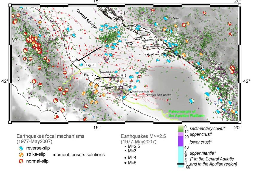
Geologia Marina 2019/2020

                Evolution of the Adriatic area
             Upper Oligocene – Lower Miocene (25 - 18 Ma)
                             Rotation of the Blocco Sardo-Corso
           From about 25 Ma, an ocean basin formed (Algerian-Provence basin) with the
           rotation of the Sardo-Corso block (which today includes Corsica and Sardinia).

                          Apennines origin
The rotation toward south-east of the Sardo-Corso block, gave origin to the
Apennine chain.

                                                             Istituto Nazionale
                                                             di Oceanografia e di Geofisica Sperimentale   8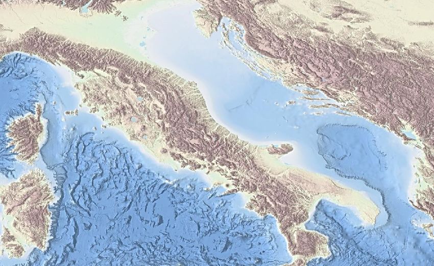
Geologia Marina 2019/2020

                           Evolution of the Adriatic area
                         Messinian salinity crisis – Upper Miocene ( ~7 Ma)

Approximately 6.9 million years ago, the slow approach and consequent collision between European and African plates
led to the closure of the Strait of Gibraltar (other causes should be sought in lowering the sea level due to a glaciation
and tectonic rise of the Mediterranean area). The Mediterranean became a closed sea, subject to intense evaporation,
which resulted in a lowering of the water level with the consequent emergence of large areas.
About 3.5 million years ago water began to enter the Gibraltar Strait again: 3000 meters high waterfall began filling the
Mediterranean basin. Of all this, there are still enormous evaporitic sequences, especially Messianic chalk, emerging from
Sicily to Monferrato.

                                                                                        Istituto Nazionale
                                                                                        di Oceanografia e di Geofisica Sperimentale   9
Geologia Marina 2019/2020

                           Evolution of the Adriatic area
                              Pliocene – Pleistocene (5 – 1.8 Ma)

Above, on the left, the Adriatic area in Pliocene time. Sea level was about 100 meters higher than the
present level, Italy was similar to a large archipelago. To the right, Italy in the Pleistocene age; the sea level
was 90-100 meters lower than the current one. The Padano plain extended to the south of Ancona (indicated
in red) and the river Po flowed into the current Fossa del Pomo, now filled with sediments.

                                                                                 Istituto Nazionale
                                                                                 di Oceanografia e di Geofisica Sperimentale   10
Geologia Marina 2019/2020
STRATIGRAPHY OF THE APULIAN PLATFORM AND ADRIATIC BASIN
(calibrated from wellbore data)
(Scisciani & Calamita, 2009)
(Casero e Bigi, 2013)
Istituto Nazionale
di Oceanografia e di Geofisica Sperimentale 10Geologia Marina 2019/2020
PLATE MARGINS CONFIGURATION IN THE WESTERN MEDITERRANEAN
1)
2)
Istituto Nazionale
di Oceanografia e di Geofisica Sperimentale 12Geologia Marina 2019/2020
EARTHQUAKES LOCATIONS LIMIT THE BORDER OF THE ADRIA PLATE
(Chiarabba et al., 2005)
Istituto Nazionale
di Oceanografia e di Geofisica Sperimentale 13Geologia Marina 2019/2020
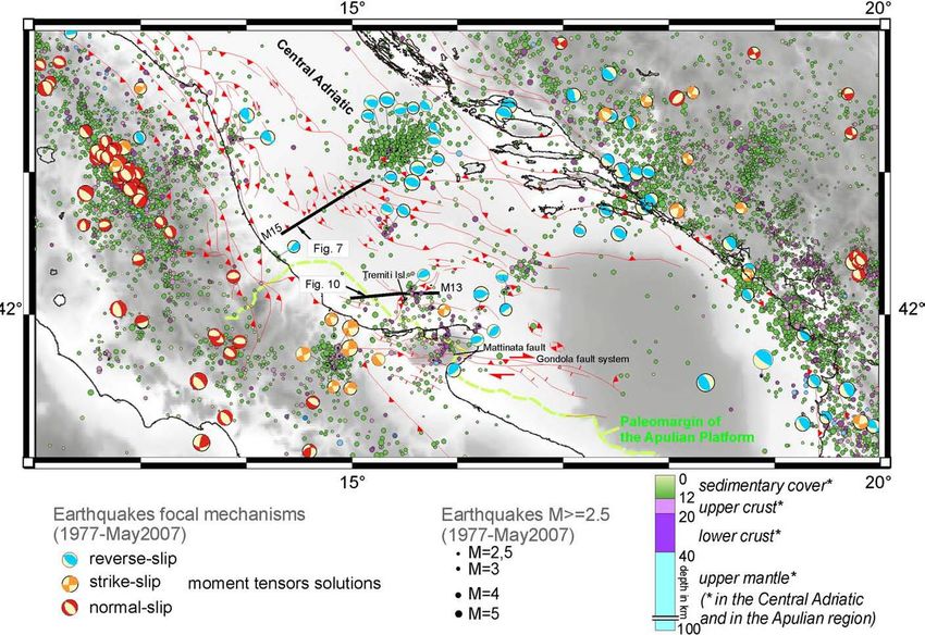
SEISMICITY OF THE ADRIATIC REGION
Hypocentral depth Focal mechanisms
M>2.5 (1977 – 2007)
(Scisciani, Calamita, 2009)
Istituto Nazionale
di Oceanografia e di Geofisica Sperimentale 13Geologia Marina 2019/2020
SEISMICITY OF THE ADRIATIC REGION
Istituto Nazionale
di Oceanografia e di Geofisica Sperimentale 14Geologia Marina 2019/2020
DISS INGV – Italian seismicity catalogue
Istituto Nazionale
di Oceanografia e di Geofisica Sperimentale 27Geologia Marina 2019/2020
NORTHERN ADRIATIC
Cuffaro et al. 2010
Structural map of the Northern Adriatic Sea region
Carminati 2003
(modified from Castellarin et al., 2006).
Istituto Nazionale
di Oceanografia e di Geofisica Sperimentale 17Geologia Marina 2019/2020
MORPHOLOGY AND PRESENT STRUCTURAL SETTING – NORTHERN ADRIATIC
PO plain
Northern
Apennine
(Fantoni & Franciosi, 2010)
Istituto Nazionale
di Oceanografia e di Geofisica Sperimentale 18Geologia Marina 2019/2020
SCHEMATIC STRATIGRAPHY from AMANDA well data
Donda et al., 2014. Deep-sourced gas seepage and methane-derived carbonates in the Northern Adriatic
Sea. Basin Research (2014) 1–15, doi: 10.1111/bre.12087
Istituto Nazionale
di Oceanografia e di Geofisica Sperimentale 312016/2017
Geologia Marina 2019/2020
SEISMOSTRATIGRAPHY – NORTHERN ADRIATIC
Donda et al., 2014. Deep-sourced gas seepage and
methane-derived carbonates in the Northern Adriatic Sea.
Basin Research (2014) 1–15, doi: 10.1111/bre.12087
Ghielmi, M., Minervini, M., Nini, C., Rogledi, S., Rossi, M.,
Vignolo, A., 2010. Sedimentary and tectonic evolution in the
eastern Po-Plain and northern Adriatic Sea area from the
Messinian to Middle Pleistocene (Italy). Rendiconti Scienze
Fisiche e Naturali Accademia Lincei 21, 131e166Geologia Marina 2019/2020
GAS SEEPS IN THE NORTHERN ADRIATIC
(Donda et al., 2014)
Istituto Nazionale
di Oceanografia e di Geofisica Sperimentale 33Geologia Marina 2019/2020
GAS SEEPS IN THE NORTHERN ADRIATIC
(Donda et al., 2014)
Istituto Nazionale
di Oceanografia e di Geofisica Sperimentale 34Geologia Marina 2019/2020
GAS SEEPS IN THE NORTHERN ADRIATIC
(Donda et al., 2014)
Istituto Nazionale
di Oceanografia e di Geofisica Sperimentale 23Geologia Marina 2019/2020
Trezze in the Northern Adriatic
Trezze, grebeni o tegnue are the names that locally, from Grado to Venice, are given to
rock formations that rise from the sandy Adriatic seabed. They have a modest extension
and constitute a "geological curiosity" which is not found in other parts of the
Mediterranean. These "islands" of rock on sandy-muddy seabed are the ideal substrate
for the establishment of sessile organisms (which must be anchored to the substrate) and
thanks to the cavities and interstices present, provide shelter to the juvenile stages of
many fish species. They represent a true oasis of biological wealth and biodiversity.
Side-scan sonar
Side-scan sonar image of the seabed on a «trezza» (PhD thesis, Emiliano Gordini 2009)
Istituto Nazionale
di Oceanografia e di Geofisica Sperimentale 24Geologia Marina 2019/2020
Trezze in the Northern Adriatic
Their origin is related to processed linked to
methane spills from the seabed. These rock
formation have grown up as real tropical reefs by
bioconstructing organisms such as calcareous
alghae, madrepores, briozoas.. The calcareous
skeletons of these organisms, stratifying one over
the other, gave birth to the current outcrops that
represent the coral reefs of the northern Adriatic.
Mutlibeam echosounder
Multibeam bathymety on a «trezza» (PhD Thesis, Emiliano Gordini, 2009)
Istituto Nazionale
25
di Oceanografia e di Geofisica SperimentaleGeologia Marina 2019/2020
Trezze in the Northern Adriatic
Affioramento sul fondo del mare dovuto ad una trezza, visualizzato con sismica ad altissima risoluzione dal sub-bottom chirp
(Tesi Dottorato, Emiliano Gordini 2009)
Istituto Nazionale
26
di Oceanografia e di Geofisica SperimentaleGeologia Marina 2019/2020
SUBSIDENCE IN THE NORTHERN ADRIATIC
As a consequence of climate change and human-induced land subsidence, coastal zones are directly
impacted by sea-level rise. Natural component of land subsidence is tectonic activity, glacial isostatic
adjustment and sediment compaction. The anthropogenic component is a consequence of the land use and
soil exploitation (i.e. pumping and gas extraction). During next decades, the combined effects of land
subsidence and of the sea-level rise in consequence of climate change are expected to enhance the shoreline
instability, leading to a further retreat.
In the map, the limits of
marine ingression expected
for 2100 for the Rahmstorf
scenarios (2007, red line) and
the 5 m contour line (in
green)
Recent natural land subsidence in the
northern Adriatic coastal area (after
Gambolati and Teatini 1998)
Istituto Nazionale
di Oceanografia e di Geofisica Sperimentale 30Geologia Marina 2019/2020
CENTRAL ADRIATIC
Structural setting
Str deformation phases:
3 main
- extensional in the late Jurassic
- contractional/transtensional in the late Cretaceous
- compressional in the middle-late Pliocene and re-activation
of pre-existing tectonic features
Geletti et al., 2008
Istituto Nazionale
di Oceanografia e di Geofisica Sperimentale 15Geologia Marina 2019/2020
CENTRAL ADRIATIC – Tectonic style
(Casero e Bigi, 2013)
Istituto Nazionale
di Oceanografia e di Geofisica Sperimentale 16Geologia Marina 2019/2020
CENTRAL ADRIATIC
Mid-Adriatic Ridge
Istituto Nazionale
di Oceanografia e di Geofisica Sperimentale 17Geologia Marina 2019/2020
CENTRAL ADRIATIC
Mid-Adriatic Ridge
Istituto Nazionale
di Oceanografia e di Geofisica Sperimentale 18Geologia Marina 2019/2020
CENTRAL ADRIATIC
Mid-Adriatic Ridge
Istituto Nazionale
di Oceanografia e di Geofisica Sperimentale 19Geologia Marina 2019/2020
CENTRAL ADRIATIC
Tremiti Ridge
Istituto Nazionale
di Oceanografia e di Geofisica Sperimentale 33Geologia Marina 2019/2020
SOUTHERN ADRIATIC
Bathymetry Structural sketch
Istituto Nazionale
di Oceanografia e di Geofisica Sperimentale 34Geologia Marina 2019/2020
SOUTHERN ADRIATIC
Stratigraphy
C
B
A
The Apulian zone (A), extending from Puglia region
to the external sector of the Ionian islands (pre
Apulian area), and characterized by thick carbonate
Triassic to Miocene neritic sequences (> 6000 m).
The Ionian zone, (B) It occupies the Southern Adriatic Sea area. Going further north
it joins the Umbria-Marche Apennines, whereas to the west it outcrops in the eastern sector of the Gargano.
It features neritic sediments up to the Early Jurassic (Early-Middle Lias), becoming pelagic up to the Middle-
Late Eocene and finally terrigeneous (flysch) up to the Early Miocene.
The Dalmatian zone, (C) outcrops along the Montenegro coastline, with neritic facies from the Triassic
to the Middle Eocene and becoming flyshoidal from the Oligocene to the Early Miocene (Aquitanian).Geologia Marina 2019/2020
SOUTHERN ADRIATIC
Structural setting
Volpi et al., 2014
Istituto Nazionale
di Oceanografia e di Geofisica Sperimentale 36Geologia Marina 2019/2020
(Argnani et al., 2012)
Istituto Nazionale
di Oceanografia e di Geofisica Sperimentale 37Geologia Marina 2019/2020
SOUTHERN ADRIATIC
Gondola fault system
A
B
A
A B B
Istituto Nazionale
di Oceanografia e di Geofisica Sperimentale 38Geologia Marina 2019/2020
SOUTHERN ADRIATIC
Gondola fault system
Seafloor evidence and shallow deformation
Ridente et al., 2010
Istituto Nazionale
di Oceanografia e di Geofisica Sperimentale 26Geologia Marina 2019/2020
HYDROCARBON EXLORATION
Istituto Nazionale 39
di Oceanografia e di Geofisica SperimentaleGeologia Marina 2019/2020
LOCATION OF THE MAIN HYDROCARBON FIELDS AND STRUCTURAL SETTING
Istituto Nazionale 40
di Oceanografia e di Geofisica SperimentaleGeologia Marina 2019/2020
Hydrocarbon reservoirs
Oil Gas
Istituto Nazionale
di Oceanografia e di Geofisica Sperimentale 42Geologia Marina 2019/2020
HYDROCARBON EXLORATION
a
b
c
a
Cazzini et al., Journal of Petroleum Geology, Vol. 38(3), July 2015, pp 255-279
Istituto Nazionale
di Oceanografia e di Geofisica Sperimentale 42Geologia Marina 2019/2020
HYDROCARBON EXLORATION
a
b
Cazzini et al., Journal of Petroleum Geology, Vol. 38(3), July 2015, pp 255-279
Istituto Nazionale
di Oceanografia e di Geofisica Sperimentale 43Geologia Marina 2019/2020
Marine strategy
In recent years there has emerged the awareness that the marine environment is
a heritage valuable and must be protected and safeguarded.
The European Parliament and the Council of the European Union have issued a directive
(transposed in Italy on October 13, 2010), which aims to reach the 'Good State of Marine
Waters'. This is a phase of preparation and study of all the most critical aspects and a
program of measures to be taken This program also includes the Mediterranean and
consequently the Adriatic.
To know the marine
environment (subsoil, water-
bottom sea interface, water
column and water-atmosphere
interface) research plays a
fundamental role.
Istituto Nazionale
45
di Oceanografia e di Geofisica SperimentaleYou can also read