Great Lakes Operational Workshop Canadian Weather Radar Replacement Project and Operational Impacts - National Weather Service
←
→
Page content transcription
If your browser does not render page correctly, please read the page content below
Great Lakes Operational Workshop

Canadian Weather Radar Replacement
  Project and Operational Impacts

                      Steve Knott
                       FSII/OSPC
                     May 1-3, 2018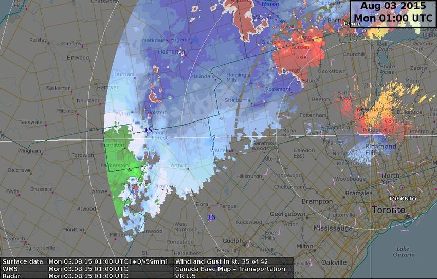
Outline
 • Radar Deployment Schedule
 • Scanning Strategies
 • Anticipated Improvements
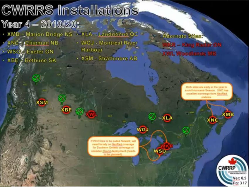
Radar Installs for 2018
                                        Installation                             SAT (Site      Old C-Band Radar
                                                                   Construction                                                  New S-Band Online
         Order         Site and ID         Year          Status                 Acceptance)        Off Network
                                                                    Start Date
                                                                                   Date
                                           (FY)                                                    (Estimated)                        (Estimated)
                     Radisson, SK
                 1                      2017/2018      Completed      11-Sep-17    08-Dec-17              15-Oct-17                    07-Feb-18
                     "CASRA"
                     Blainville, QC                                                                                                    30-Sep-18
                                                                                              NA (McGill radar
                 2                      2018/2019      On track       16-Apr-18     20-Jul-18 available until Sept     (data available internally by late July, but
                     "CASBV"                                                                  30, 2018)                with periodic outages due to training and
                                                                                                                          testing requirements on new radar)
                     Foxwarren, MB
                 3                 2018/2019           On track       14-May-18    17-Aug-18               25-Jun-18                   31-Aug-18
                     "CASFW"
                     Timmins, ON
                 4                      2018/2019      On track       11-Jun-18    14-Sep-18               23-Jul-18                   28-Sep-18
                     "CASTI"
                     Spirit River, AB                                                                      25-Jun-18
                                                                                               (old radar must be
                 5                      2018/2019      On track        09-Jul-18   12-Oct-18                                           26-Oct-18
                                                                                               decommissioned prior
                     "CASSR"
                                                                                               to new radar
                                                                                               construction)
1 portable x
band 2018
Available for
gap filling
deployment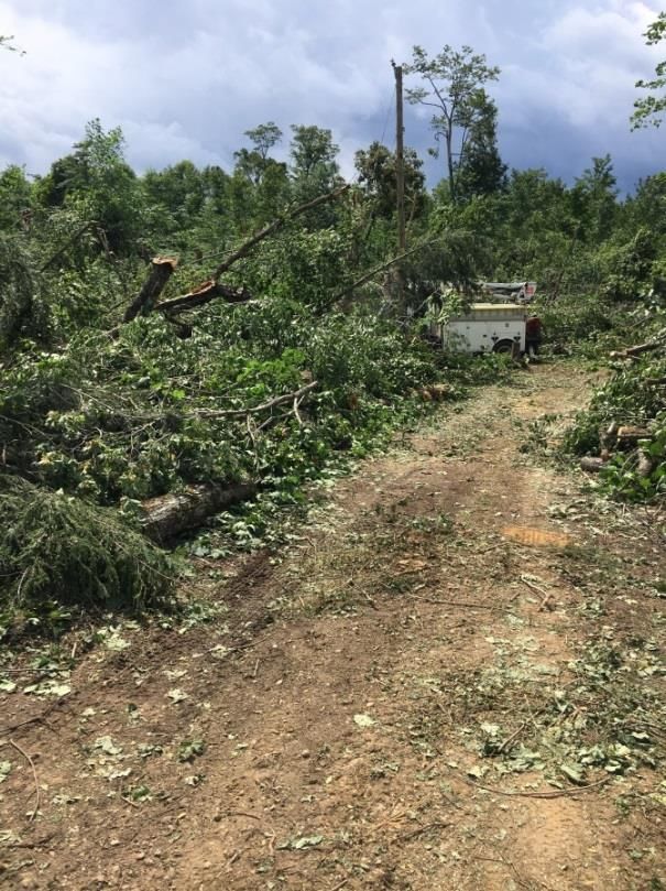
Radar installs for 2019

                          2 portable
                          x-band radars
                          available for
                          gap filling
                          deployment
                          2019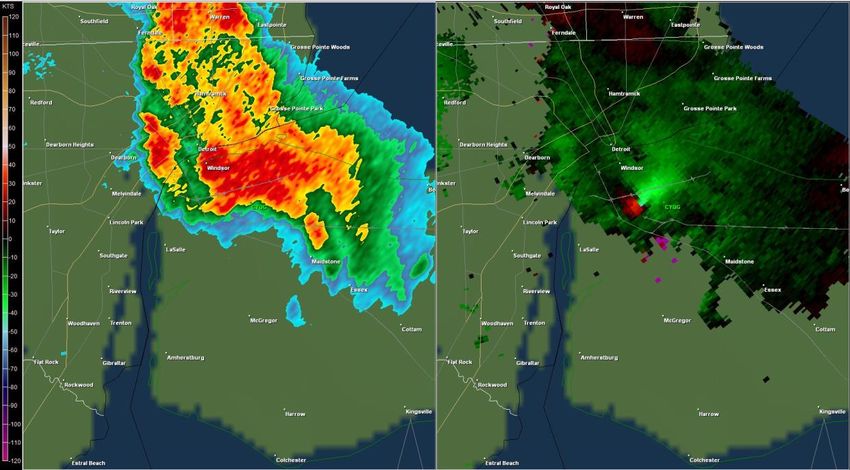
Portable X-band Deployment
                 Portable x-band radar          URP / NinJo
             •   Originally deployed to cover   XBV products
                 anticipated gap for Montreal   available*:
                 area                           • CAPPI
             •   Experienced considerable beam • MaxR
                 blockage at XBV to the west    • Echo Top
                 ~240-300    0
                                                • SVRWX
             •   Another deployment this Spring • WDRAFT
                 to cover convective area of    • VIL
                 southwestern Manitoba
                                                • VIL Density
             •   7 scan angles every 5 minutes,
                                                • VIZ
                 reflectivity and vr
                                                • Hail
             •   Range = 100km (~ 60 mi), vr is
                                                • Hail MESH
                 48ms-1
                                                • HAIL POSH
             •   Stand alone imagery, not to be
                                                • CoTPPI
                 fully integrated into URP
                 software suite ie Storm cell   • BWER
                 identification or URP          • PPI - DBZ
                 composites                     • PPI - VR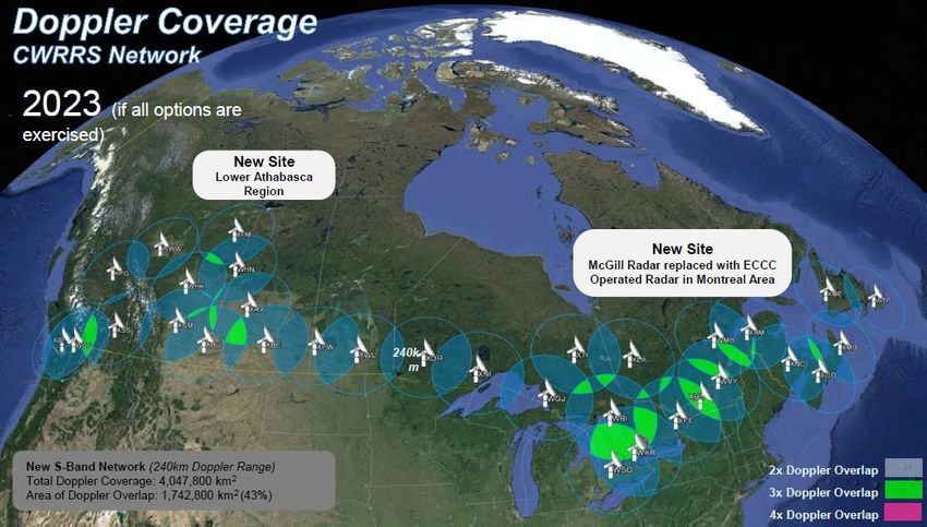
Current C band Scanning Strategy

 • CONVOL and DOPVOL
     mode alternate every 5
     minutes
 •   CONVOL: 5 mins for 24

                                 Height (km)
     reflectivity angles
 •   DOPVOL: 5 mins for 3
     Doppler angles; LOLAA,
     1.5 and 3.5
 •   Vr range 120km with
     upper bound of 48 ms-1
 •   Results in time increment
     of 10 minutes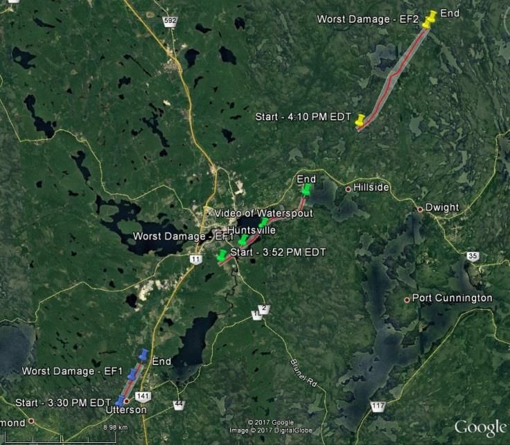
Selex: Six-minute polar volume S-band:
PVOL6S
                       • Similar to NEXRAD
                           ie no longer separate
                           reflectivity and
                           doppler modes
                       •   Vr range 240 km
                       •   6 min time increment
                       •   Polarized products
                       •   Not Site configurable
                       •   Potential for
                           intermediate 3min
                           lowest level scan
                           may be discussed
                           later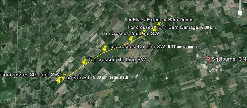
Radar Harmonization
                 • Current Canadian C-band scan
                     strategy is time synchronized
                 •   As the project evolves Canada’s
                     radar network to be a collage of
                     radar frequencies and scan
                     strategies
                 •   New S band will utilize 6 minute x
                     17 elevation scan strategy
                 •   Existing C band will remain first 5
                     mins: 24 reflectivity angles, then 5
                     mins: Doppler scan mode
                 •   No immediate timeline for radar
                     scan strategy harmonization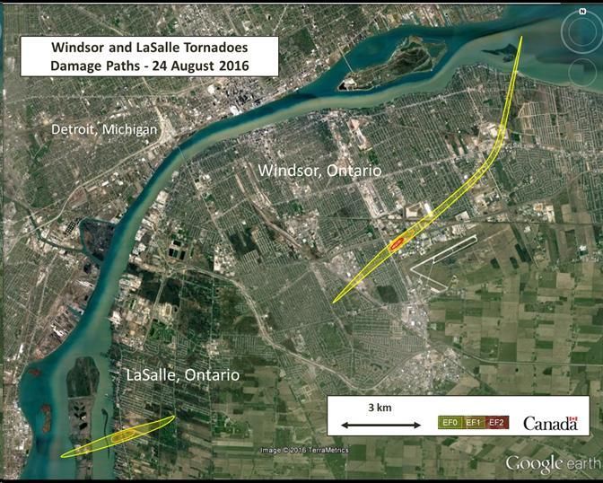
Planned URP Releases: A Recap

      Release     Date      Requirements: High Priority and Highly Desirable
 1)   URP 2.10   Deployed   X-band radar data integration for XBV
                 Jul 2017   •   Existing single radar volume products
                            •   DBZ and VR PPIs
 2)   URP 2.11    Target    Phase 1: S-band radar data integration
                 Feb 2018   •  Existing single radar volume products
                            •  DBZ and VR PPIs
                            •  Dual pol PPI products (moved up from URP 2.12)
                            •  Storm relative velocity for C-band
                            •  NEXRAD Level 2 processing
                            •  NUMERIC format modification for CMOI
 3)   URP 2.12    Target    Phase 2: S-band radar data integration
                 Oct 2018   •  Existing precipitation accumulation products
                            •  Existing Doppler products
                            •  Composites (C, S, X-band)
                            •  Further NEXRAD Level 2 processing & integration
 4)   URP 2.13    Target    Phase 3: S-band radar data integration
                 Apr 2019   •  Existing severe weather/SCIT (S and C-bands)
                            •  New particle classification
                            •  New dual pol QPE
                            •  New/improved data quality including an enhanced
                               PRECIP/ET product for S-band
                            •  Change SCIT table units (deferred from URP 2.11 to
                               coordinate with NinJo 3 release)
                            •  Further NEXRAD Level 2 processing & integration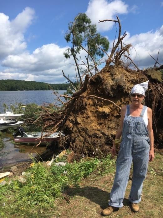
Examples of Past Shortcomings
• Limited Doppler Range
– Huntsville Tornadoes - 4 Aug 2018
– Windsor Tornadoes - 24 Aug 2016
• Attenuation issues
– Mount Forest Heavy rain - 23 June 2017
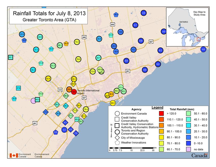
– Toronto Heavy Rain – 8 June 2013
• Dropped Radar Bins
– Teviotdale EF2 – 2 Aug 2016
– Shellbourne EF1 – 18 April 20134 Aug 2017: Huntsville, ON
King Radar: 1.5km Cappi
Positive and negative ltng only                                Total Lightning

       •   King 120km Doppler range ends at Bracebridge
       •   Britt radar Doppler range ended at Huntsville
       •   Mesocyclones not depicted for SCIT*
       •   At 1950z, echoes appear to transform into numerous discrete cells, later cell mergers
           seem likely though difficult to tell with 10 minute increments
       •   3 Confirmed Tornadoes in Forested area, possible more occurred
       •   Selex S band will extend Doppler range, also have Dual Pol CC product at 6 min time
           intervals, and integrated eventually into SCIT
       •   At 20:10z appears to be some attenuation, at 2030z radome wetting at King further
           diminishes signal
Windsor Tornadoes24 Aug, 2016
Radar images near 2020z
URP - Detroit Nexrad - DetroitStorm Cell Identification Table
- OSPC monitors
8 Ontario radars
plus several
upstream US
radars
- SCIT a means
for Situational
awareness
- Windsor Cell
ID:1496 is
12th ranked and
indicated as weak
-MESO is NA
- Outside of
Exeter radar
120km doppler
range
= Ontario radar23 June 2017
Nocturnal Heavy rain Event
Quick Case StudyGeneral Synoptic pattern
Source: Weather Prediction Center
• Significant flooding occurred over
portions of southwestern Ont with a
general 75-150 mm in 12 hr time frame
• Grand River Basin hard hit
• Note: These maps illustrate Synoptic
situation approx 9 hrs after the onset of
this Heavy rainfall Event over Swrn Ont
• Radar loop does show some outflow
boundaries which appear to have setup
in east-west orientation; further south of
the synoptic scale front shown on the
WPC analysis.12 Hr Loop of 1.5km CAPPI
Note: Lightning is 30 min trace
Attenuation observed results
in Concentration of lightning
Strikes but with minimal
Radar signal
• Scattered Convection transforms into an organized east west line of
Training Convection.
• King experiences significant attenuation due west
• Operations was not aware of the magnitude of the rainfall event till
climate observations became available some 6 hrs after the eventCoCoRaHS and King Rain Accumulation *Significant Attenuation and Radome Wetting at King Radar vastly underestimates Rainfall Amounts (QPE) *King does not show any values above 40 mm • MOUNT FOREST: 158 • MONO CENTRE: 101 • GODERICH: 91.9 • POINT PETRIE: 77.5 • COBOURG: 54.3 • TORONTO BUTTONVILLE AIRPORT: 50 • UXBRIDGE: 43.7 • ELORA: 43.4 • TORONTO PEARSON AIRPORT: 36.2 • MILDMAY: 137.4 (COCORAHS) • ORANGEVILLE: 128 (COCORAHS) • PALMERSTON: 121.9 (COCORAHS) • LUCKNOW: 108.7 (COCORAHS) • BRUSSELS: 95 (COCORAHS) • MILFORD: 71.4 (COCORAHS) • SCHOMBERG: 66.8 (COCORAHS) • ELORA: 56.6 (COCORAHS) • AURORA: 55.9 (COCORAHS) • BAYFIELD: 51.1 (COCORAHS)
A Billion Dollar Flash Flood in Toronto –
Meteorological Analysis and Operational
Considerations

  David Sills1, Arnold Ashton2, Steve Knott2, Sudesh Boodoo1,
        Joan Klaassen1, Stéphane Bélair1 and Helen Yang2
                  1Science   and Technology Branch
                 2Meteorological  Service of Canada
The Event and Impacts • 8 Jul 2013 2000-0500 UTC, worst 2020- 2210 • 50-130 mm of rain across much of Greater Toronto Area, a 100-yr return period storm • Significant Disruption to Transportation • $850M+ in insured losses, and with uninsured losses surely more than $1B, exact cost unknown • The costliest natural disaster in Ontario history!
8 July 2013
   At 2100z the main storm has moved over the GTA, however just after 2100z
   some cells move over King city radar and significantly reduce the Reflectivity
   values of the Rain. This is caused by a combination of Radome wetting and
   attenuation, the drop is significant and was noticed by meteorologists on shift
The Event and Impacts
• 8 Jul 2013 2000-0500 UTC, worst 2020-
2210

• 50-130 mm of rain across much of Greater
Toronto Area, a 100-yr return period storm

• 126 mm at Pearson International Airport,
broke 1954 Hurricane Hazel single-day
rainfall record

• Major Disruption to Public Transport

• $850M+ in insured losses,
and with uninsured losses
surely more than $1B,
exact cost unknown

• The costliest natural
disaster in Ontario history
8 July 2013: Toronto Urban Flood

•   King radar Pcpn Accum: Actual measured
    rainfall amounts were 126 mm at Pearson        Buffalo Rainfall Estimates: Although it is difficult to get an exact sense
    airport, 85 mm at Toronto island airport and   of the geography over the GTA, especially since the background
    93 mm Toronto downtown. Rainfall estimates     geography only shows the American portion of lake Ontario, Buffalo’s
    from King were on the order of 40-50 mm, a      S band radar showed maximum values of 4 to 5 inches or 100-125 mm,
    significant underestimation.                   this is much closer to what was measured in the GTA.
Dropped Radar Bins near Mesocyclone
Teviotdale, Ontario –Confirmed EF2

                         Teviotdale

Teviotdale confirmed EF2 tornado ~ 9:00pmTeviotdale, Ontario –Confirmed EF2
Teviotdale
Teviotdale confirmed EF2 tornado ~ 9:00pm18 Apr 2013 EF1 @ Shelburne • Occurred at leading edge of small bowing segment along QLCS – rain- wrapped! • 10 km track beginning 2133 UTC - reports
1.5°

Actually more like 2132 Z…
1.5°

Actually more like 2132 Z…
Laurel Station (NW of Orangeville)
Summary

• The CWRRP is a 7 year infrastructure program which will phase in
  20 new S band radar systems with 13 additional options from SELEX
• S band radar scan strategy will result in 17 angles every 6 minutes,
  with a lowest angle near 0.4 degrees, and increased radial velocity
  range of 240 km.
• There will be a phased approach taken for the development of
  MSC’s internal radar viewing software
    – Dual Polarized products ready upon deployment, but Dual Pol QPE and Particle
      Classification not likely until Spring of 2019
    – Integration of S band data into Storm Cell Identification Table not likely until
      Spring of 2019
• It is anticipated that the S band Dual Pol radars will be a significant
  improvement to detecting Summer Convective Weather as well as
  phase issues for Winter synoptic scale storms.
You can also read