GREAT LAKES WATER LEVELS - Missy Kropfreiter, PE Hydraulics & Hydrology Office Detroit District, Corps of Engineers 30 June 2020
←
→
Page content transcription
If your browser does not render page correctly, please read the page content below
GREAT LAKES WATER LEVELS

Missy Kropfreiter, PE

Hydraulics & Hydrology Office
Detroit District, Corps of Engineers
30 June 2020

                                       NWS-GRR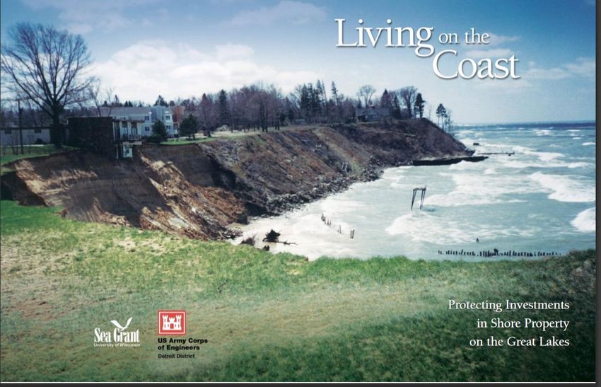
2
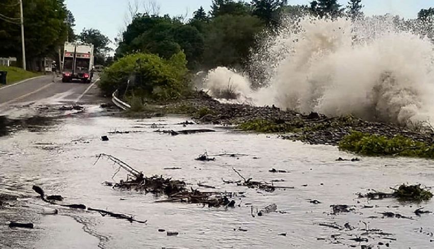
HIGH WATER PHOTOS ACROSS THE GREAT LAKES
Canal Park South Haven, MI
Near Duluth, (NWS)
MN (NWS)
Stony Point, MI
Lake Erie Oswego, NY
(Port of Monroe) (Bill Foley)
The impacts of high water levels have been felt across the basin.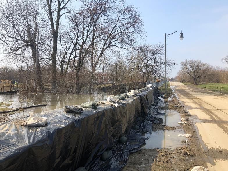
3
NOTES ABOUT GREAT LAKES WATER LEVELS
• Not a depth, but an elevation above sea level, IGLD 1985
• Michigan and Huron = One lake
• Lake-wide daily means Lake-wide monthly means
• Based on still water, not influenced by meteorological forcing
• Based on a network of water level gauges
• Detroit District Corps of Engineers = keeper of official monthly water
level statistics from 1918-2019
• Coordination occurs with Environment and Climate Change Canada
• Primary drivers of water level fluctuations are changing weather
patterns and resulting fluctuations in water supply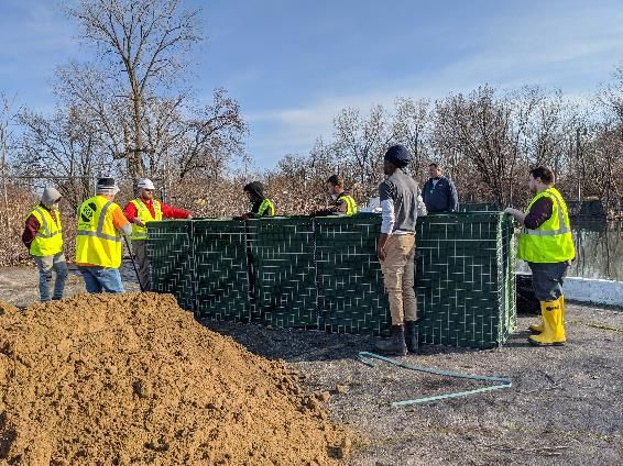
4

     MONITORING GREAT LAKES WATER LEVELS
The Great Lakes Basin
•   14,000 miles of shoreline
•   95,000 square miles of water
•   200,000 square miles of land
•   8 States & 2 Provinces

             Outflow regulation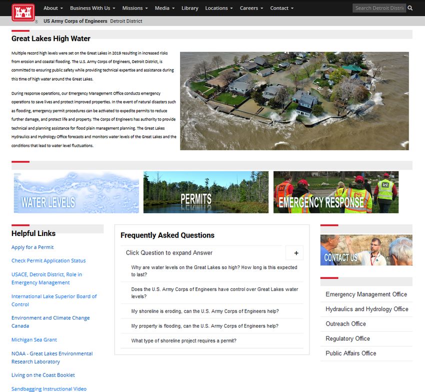
5

MONITORING GREAT LAKES WATER LEVELS

Daily Average Water Levels Based on Lake-Wide Average Network
 •   Lake Superior: Duluth, Marquette, Pt. Iroquois, Thunder Bay, Michipicoten
 •   Lakes Michigan-Huron: Harbor Beach, Ludington, Mackinaw City, Milwaukee, Tobermory, Thessalon
 •   Lake St. Clair: St. Clair Shores, Belle River
 •   Lake Erie: Toledo, Cleveland, Port Stanley, Port Colborne
 •   Lake Ontario: Oswego, Rochester, Toronto, Kingston, Port Weller, Cobourg
6

ANNUAL WATER LEVELS AND THE HYDROLOGIC CYCLE

  WINTER       SPRING       SUMMER            FALL

               Snow melt,    Increased
Snow           rainfall,     sunshine     Increased
accumulation   increased     warms        evaporation
               runoff        lake water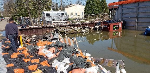
7

  FACTORS IMPACTING WATER LEVELS

                                                       Net Basin
                                                        Supply

                              Precipitation
                Evaporation
Inflow from

                                              Runoff
Upstream Lake

                                                                   Outflow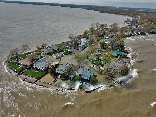
8
Decade plus of
               Record rise and
low water with
record lows
               record highs
9

               WHY ARE LEVELS SO HIGH? – WET PATTERN

                                                                           Last 3 years
                                                                           (2017-2019),
                                                                           exceptionally
                                                                           wet for the
                                                                           Great Lakes
                                                                           Basin.

NOAA National Centers for Environmental information, Climate at a Glance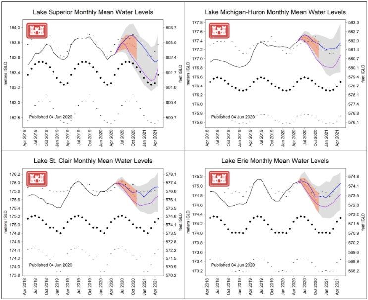
10

                           RECENT SPRING CONDITIONS

• During the spring, drier conditions were felt in the   • Although March was much warmer than normal, April
  Lake Superior and Ontario basins, while the central      and May were cooler than normal, causing the overall
  areas of the GL basin experienced wetter conditions.     spring mean temperature to be near normal.
11
MONTHLY AND SEASONAL OUTLOOKS
TEMPERATURE PRECIPITATION
July
ONE MONTH
OUTLOOK
Jul-Aug-Sep
THREE MONTH
OUTLOOK12
6-MONTH FORECAST (JUNE-NOVEMBER)
• 2019 Records
• 2020 Provisional Record
Projected Levels (dashed
green line):
• In period of seasonal rise
• May 2020 level was 4
inches above the May 2019
level.
• Forecast to be less than 1
inch above record high June
level, 1 to 2 inches below
record highs from July to
Sept., and 7 to 9 inches
below record high levels in
Oct. and Nov.
https://www.lre.usace.army.mil/Missions/Great-Lakes-Information/Great-Lakes-Water-Levels/Water-Level-Forecast/13 June 2020 Forecast
14
June 2020 Forecast
15

THE “WHAT IF” WATER LEVEL OUTLOOK

                              Scenarios driven based on
                              historical supplies from
                              2012-2013 (dry) and 2017-
                              2018 (wet)

                      https://www.lre.usace.army.mil/Missions/Great-Lakes-
                      Information/Great-Lakes-Water-Levels/Water-Level-
                      Forecast/Water-Level-Outlook/
16
KEY POINTS
• Water level fluctuations are primarily driven by weather and hydrologic
conditions.
• Except for Lake Michigan-Huron, all lakes forecast to peak below 2019
levels.
• Regulation of outflows (St. Marys and St. Lawrence) cannot prevent
extreme high or low water levels nor fully control water levels
• Impacts of high water are expected to be felt throughout 202017
LIVING ON THE COAST
https://www.lre.usace.army.mil/Portals/69/docs/GreatLakesInfo/docs/CoastalProgram/Living%20o
n%20the%20Coast%20Booklet.pdf?ver=2016-06-06-105107-683WATER LEVEL RESOURCES 18
19

HTTPS://WWW.LRE.USACE.ARMY.MIL/ABOUT/GREAT-LAKES-HIGH-WATER/

                                     Water Level Contacts
                                     John Allis
                                     313 226 2137
                                     John.t.allis@usace.army.mil

                                     Deanna Apps
                                     313 226 2979
                                     Deanna.Apps@usace.army.mil
2019-2020 GREAT LAKES HIGH WATER EMERGENCY MANAGEMENT SUPPORT U.S. ARMY CORPS OF ENGINEERS DETROIT DISTRICT Krystle Walker Emergency Management Specialist
21

     How can the Army Corps
of Engineers help my community??

   1.   Immediate emergency assistance
          2. Long-term solutions
22
USACE EMERGENCY AUTHORITIES
Authorities provided by Congress:
33 U.S.C. 701n (commonly referred to as Public Law (PL) 84-99):
Localized events
“The Chief of Engineers is authorized to undertake activities, including disaster
$ preparedness, Advance Measures, emergency operations, rehabilitation of flood control works
threatened or destroyed by flood, protection or repair of Federally authorized shore protective
works threatened or damaged by coastal storms, provision of emergency water due to drought or
contaminated source, emergency dredging, and flood-related rescue operations.”
Robert T. Stafford Disaster Relief and Emergency Assistance Act (42 U.S.C. 5121 et seq.) (The
Stafford Act):
Presidentially-declared or major disasters
$ FEMA may direct Federal agencies to use available personnel, supplies, facilities, and
other resources to provide assistance in the event of a major disaster or emergency declaration.23 PUBLIC LAW 84-99 –Authority that allows USACE to provide emergency operations support to communities –Federal assistance is meant to SUPPLEMENT local resources just prior to or during an event. –All resources must be exhausted, or nearly exhausted, by the City, County, and State. –Request is made by the State to USACE.
24

PUBLIC LAW 84-99

 Erosion cannot be addressed by USACE under
       emergency response authorities.
25
TYPES OF EMERGENCY ASSISTANCE – TECHNICAL
Technical assistance consists of providing review and recommendations
in support of state and local efforts, and helping determine feasible
solutions. Some examples of technical assistance are:
1. Providing experienced personnel to give guidance on flood fight
techniques and emergency construction methods.
2. Providing personnel to inspect existing flood protection projects to
identify problem areas and recommend corrective measures.
3. Providing hydraulic analysis, geotechnical evaluations, topography
and stream data, maps, and historic flood or storm information.
No cost to customer26
Types of Assistance
TYPES OF EMERGENCY – Technical
ASSISTANCE – TECHNICAL
District Flood Fight Team
• Made up of trained and dedicated
USACE employees as a collateral
duty.
• Trained in principles of public
communication and flood fight
techniques.
• Bring other expertise such as
geotechnical, structural,
hydrological, and hydraulic
engineering.27 STATUS OF CURRENT EVENT –MI counties receiving technical assistance for 2019-2020 lakeshore flooding: • Allegan • Emmet • Newaygo • Wayne • Bay • Macomb • Ottawa • Charlevoix • Monroe • St. Clair • Cheboygan • Muskegon • Van Buren –Typical technical assistance requests • Sandbagging technique • Sandbag placement
28

FILLING SANDBAGS
29

2019 TECHNICAL ASSISTANCE EFFORTS

                                    29
30
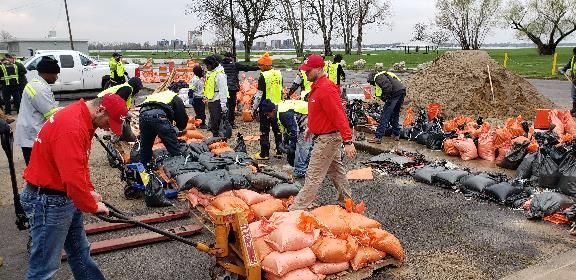
TYPES OF EMERGENCY ASSISTANCE - DIRECT
Supplies and Equipment: Sandbags, plastic sheeting, HESCO
barriers
• To be used for protection of public infrastructure. Not to be used for private
residences or private businesses. Ideally the supplies are used in a
community planned and led effort.
• Supplies that are unused are to be returned to USACE. Supplies that are
used have to be reimbursed at the USACE cost to replace.
***Unless the area receives a Presidential Declaration.
• All supplies need to be picked up by the requesting agency (county officials,
local public works, etc.) from a USACE staging area31 2020 DIRECT ASSISTANCE EFFORTS
32

PUBLIC LAW 84-99

Erosion cannot be addressed by USACE under
      emergency response authorities.

                  BUT…
33 EROSION PROTECTION PROJECT PERMITS It’s important to know that placing structures for erosion protection may require federal, state, county, and/or city permits. USACE is a regulatory agency that has permitting authority for projects along the lakeshore. USACE works in partnership with EGLE for permitting activities in the state of Michigan. To apply for a permit or learn more about the process please visit: https://www.lre.usace.army.mil/Missions/Regulatory-Program-and-Permits/Apply- For-A-Permit/
34

LONG-TERM SOLUTIONS
USACE also has the ability to complete studies or construction to
address erosion and/or other flood mitigation issues under non-
emergency authorities

To learn more about the full catalog of USACE programs please visit:
https://www.lre.usace.army.mil/Missions/Planning/Technical-Planning-Assistance/
35

CONTINUING AUTHORITIES PROGRAM (CAP) SUMMARY
36

SECTION 205 – FLOOD RISK MANAGEMENT

 Authority: Flood Control Act of 1948 (PL 80-858), as amended.

 Cost Share: 65% Federal, 35% Local. $10M Federal limit.

 Types of Assistance: Work under this authority provides for local
 protection from flooding by the construction or improvement of
 structural flood damage reduction features such as levees,
 channels, and dams. Non-structural alternatives are also to be
 considered, and may include measures such as installation of
 flood warning systems, raising and/or flood proofing of structures,
 and relocation of flood prone facilities.

 Timeline: 2-10 years, if approved and funded
37

FLOOD PLAIN MANAGEMENT SERVICES
PROGRAM (FPMS)
  Authority: The program’s authority stems from Section 206 of the 1960 Flood Control Act (PL 86-645),
  as amended.

  Cost Share: 100% Federal, typically for smaller studies, approximately 75,000.

  Purpose: People who live and work in the flood plain need to know about the flood hazard and the
  actions they can take to reduce property damage and prevent the loss of life caused by flooding.

  Types of Assistance:
  Technical Assistance - program develops or interprets site-specific data on obstructions to flood flows,
  flood formation and timing; and the extent, duration, and frequency of flooding. It also provides
  information on natural and cultural flood plain resources of note, and flood loss potentials before and
  after the use of flood plain management measures.

  Planning Assistance - provides assistance and guidance in the form of "Special Studies" on all aspects
  of flood plain management planning. Typical studies include: Flood Plain Delineation/Flood Hazard
  Evaluation, Flood Warning/Preparedness, Flood Damage Reduction, Urbanization Impact, Stormwater
  Management Studies, Flood Proofing Studies, Inventory of Flood Prone Structures

  Timeline: 1-2 years, if approved and funded
38

KEY TAKEAWAYS

1. 2020 will see a continued pattern of record or near-record lake
   levels. What will 2021 bring?
2. USACE is partnered with the Michigan State Police EMHSD and
   your county emergency management programs. If you have
   any questions or concerns, be sure to contact your city or
   county emergency management point of contact.
3. Be sure that you are aware which permits are needed when
   placing erosion protection structures.
4. There are several USACE programs that can be used to
   address flooding and erosion issues, but these will take time to
   implement, if approved.
39

     LIVING ON THE COAST
https://www.lre.usace.army.mil/Portals/69/docs/GreatLakesInfo/docs/CoastalProgram/Living%20o
n%20the%20Coast%20Booklet.pdf?ver=2016-06-06-105107-683
40
WHO CAN I CONTACT?
HTTPS://WWW.LRE.USACE.ARMY.MIL/ABOUT/
GREAT-LAKES-HIGH-WATER/
Hint: Search Detroit District High Water in your favorite
search engine
Questions about lake levels?
Deanna Apps
(313) 226-2979
Deanna.Apps@usace.army.mil
Questions about emergency
management or technical assistance?
1. Call your local emergency management
agency
2. Detroit District Emergency Management:
CELRE-EOC@usace.army.milYou can also read