Greenwich Park Geotrail - Devised by the London Geodiversity Partnership
←
→
Page content transcription
If your browser does not render page correctly, please read the page content below
Greenwich Park Geotrail
     Devised by the London Geodiversity Partnership

         http://londongeopartnership.org.uk

                                 1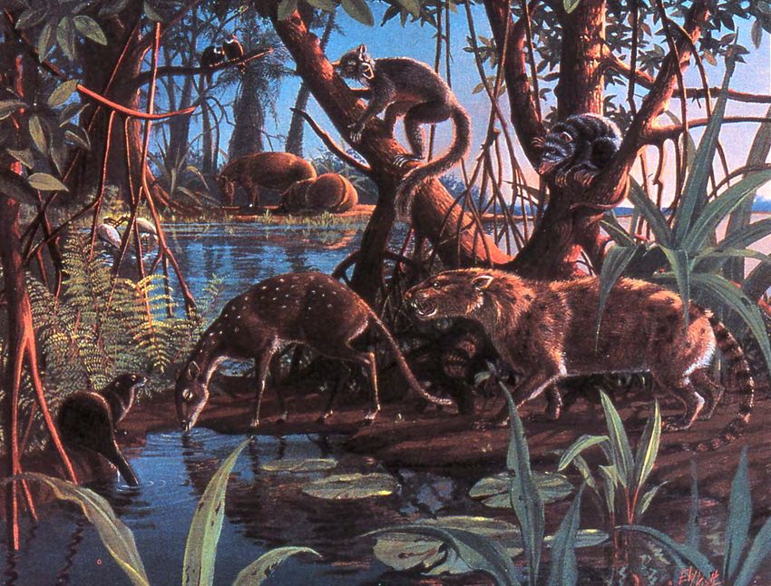
Greenwich Park Geotrail
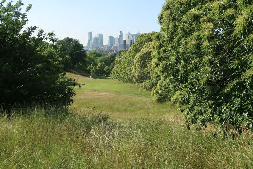
Greenwich Park is the oldest enclosed Royal Park covering 73 hectares with views across the River
Thames to the Docklands and the City of London. It lies in one of the most interesting geologically
areas of Greater London as nearly all the different rock types to be found are in the close vicinity,
several under the Park itself. This 5km long geotrail has been designed to demonstrate the effect of
the geology on the landscape. Greenwich Park is part of Maritime Greenwich World Heritage site.
The walk starts from the Thames Path at Greenwich foot tunnel and then, through the Old Royal
Naval College (formerly Royal Hospital for Seamen) and past Queen’s House (part of the National
Maritime Museum) to enter Greenwich Park at Jubilee Gate. It finishes back on the Thames Path.
The Pavilion Tea House makes a good halfway stopping off point and is conveniently placed near the
famous Greenwich Meridian. The geotrail is mostly on metalled paths; there are some steep slopes.
The nearest station is Cutty Sark for Maritime Greenwich on the DLR, 20 minutes from Central
London. The Cutty Sark is a short walk from Greenwich and Maze Hill railway stations. The nearest
Underground station is North Greenwich on the Jubilee line, then bus 129 to Greenwich town
centre. Several bus routes have stops close by: 188, 199, 129, 177, 180, 286 and 386. Access by
riverboat to Greenwich Pier is from Westminster, Embankment or Tower Piers. There are nearby
toilet facilities in Cutty Sark Gardens, King William Walk. Cost 50p, disabled free. Also, free toilet
facilities in the Tourist Information Centre in Cutty Sark Gardens, open 10.00-19.00.
Overview of the geology
Greenwich Park is geologically interesting as more than four different geological strata underlie the
Park. The differences between them are responsible for the spectacular views from the higher
ground across the Thames to the hills on the far side. The high ground of the Blackheath plateau
falls steeply away by about 25m to the low ground adjacent to the Thames, affording views right
along the length of the escarpment. The geology is also responsible for the numerous springs that
rise along the steep slope, one of which has cut back into the plateau that extends onto Blackheath
at the southern end.
Stop 1: Thames Path at the Greenwich Foot Tunnel entrance (TQ 382 779)
This entrance is on the south side of the river, in sight of the Cutty Sark.
Greenwich Foot Tunnel, opened 1902
There is a display board outside the foot tunnel which gives the history of the tunnel and some
geological information. Unfortunately, it contains a number of misleading statements relevant to
the geology. Although it states that the tunnel was dug through chalk, it appears mainly to have
been cut in the very variable sands and clays of the Lambeth Group and perhaps partly in Thanet
Sand. It was excavated by hand but under compressed air. The top of the Chalk in the tunnel area is
at about 33m below sea level (14m below the base of the tunnel).
The Docklands Light Railway tunnels beneath, opened in 1999, were mainly excavated in the very
variable Lambeth Group but at their deepest (about -26m below sea level) penetrate the Thanet
Sand.
2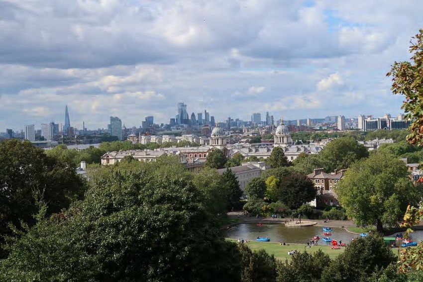
It is worth pointing out that the Meridian Estate blocks of flats immediately to the west are clearly
built on a ground level perhaps 2 m lower than those of the Footway Tunnel cupola, Greenwich Pier
and the Royal Naval College. The higher level is that of the lowest river terrace and the lower level
that of the Thames flood plain. Building on the floodplain requires the construction of river
embankments to keep out the highest river and tidal floods.

The younger sediments
The Thames floodplain is underlain by Alluvium – a mix of clays, sands and pebbles eroded from
older rocks and deposited over the last 10,000 years once the most recent of the ice ages had fully
melted. A few steps south from the tunnel, the underlying stratum is the Kempton Park Gravel, the
youngest exposed of the Thames Terraces laid down between 100,000 and 50,000 years ago. Both
these young sediments are just a few metres deep and either at or near the surface, overlying the
deeper rocks that are encountered in the tunnel and to be found underfoot within Greenwich Park.
There is a time gap of about 50 million years between the younger rocks and the older rocks of the
Eocene (see stratigraphic column on next page).

                                                 3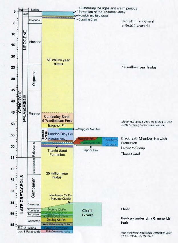
Stratigraphic column of the strata beneath London. Those in Greenwich Park are indicated and
others outside the park are labelled appropriately (after Mortimore in GA Guide 68, 2010)
                                              4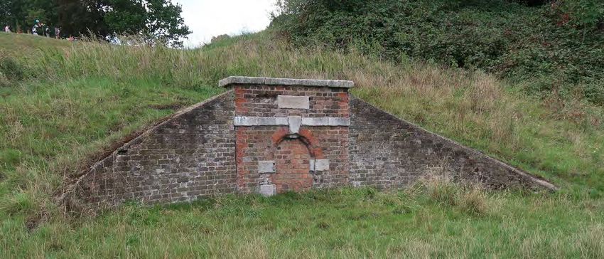
Geology map of the area with the route of the Geotrail shown in blue.

Head east along the Thames Path and then turn right through the Water Gate and walk between
the two symmetrical domes of Royal Naval College. Turn right at the fence to cross Romney Road
at the pedestrian crossing. Enter the Maritime Museum grounds and walk around the left side of
the museum building, past Queen’s House to enter Greenwich Park at the Jubilee Gate, walk along
Jubilee Footpath, branching right to cross The Avenue and grass towards Stop 2.

Stop 2: Conduit House (TQ 386 772)

Springs in the Park
The Conduit House, otherwise known as the Standard Reservoir, is an obvious landmark to help
explain how the many springs in the Park have been put to good use over the centuries, providing
water to the neighbourhood. Water was an important factor in the siting of the former Military
Hospital for Seamen. Water collected via lead pipes from springs in the slope behind the Conduit
House was then channelled in brick-built conduits, tall enough to walk through, both to the Hospital
and to the Hyde Vale Conduit, outside the Park to the west.

                                                 5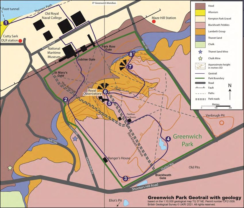
S                                                                                               N

                                 The slope towards Conduit House

                                      Conduit House in 2017
                                   Photo: Theresa Ball, April 2017

The Standard Reservoir Conduit House forms part of the water supply system, which was built in the
late 17th century or early 18th century. It covers a reservoir and is attributed to the architect
Nicholas Hawksmoor, Clerk of Works at Greenwich between 1698 and 1735. The geology is key to
the listed building’s functional role in delivering water from springs to the former Royal Hospital for
Seamen (now Old Royal Naval College) at the bottom of the hill.

The geology and topography of the park dictates the position of the springs. Water falling on the
plateau of Blackheath pebbles percolates through gravel and sand and is forced to the surface when

                                                  6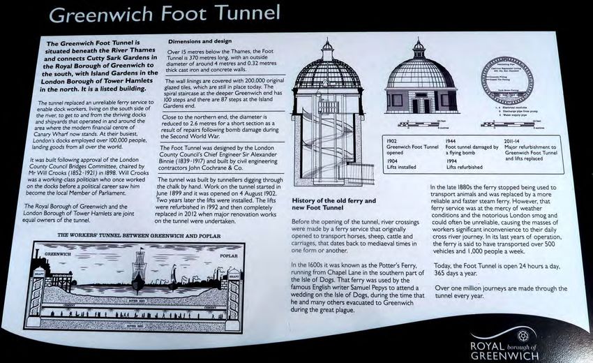
it meets a layer of clay, about 15m below the top of the slope. Some water penetrates the denser
sand of the Woolwich beds (part of the Lambeth Group) below to emerge as a second spring line
lower down the hill. There is a spring just behind the Conduit House which can be examined by
clambering up the slope.

                                                    Mr Strutt’s photograph of the brick-lined
                                                    conduit in about 1900.

                                                    From the Subterranean Greenwich website
                                                    (see reference at the end of this geotrail).

 Cross section of Greenwich Park extended north under the Thames showing location of springs on
 the steep slope. They occur when pebbles or sand meets less permeable rock types (mostly clays).
                                    Drawn by Paul Rainey 2017
                                                7
Head uphill bearing right past Queen Caroline’s Bath. Approaching the Dell, bear left and enter
the Dell opposite a tall tree stump. On the route up the steep slope from the National Maritime
Museum you will have climbed up the succession from the Thanet Sand to the Lambeth Group
(junction at the Conduit House), then up the successive sands and clays that make up the Lambeth
Group (Upnor Formation Sand at the base, with probably some Reading Formation sands and
mottled clays and the Woolwich Formation with its shell beds between various sand and clay
layers). Finally, you will arrive at the plateau which is underlain by gravel of the Blackheath beds.
Apart from tell-tale spring lines you are unlikely to be able to see the junctions and certainly not
the rock strata unless there are temporary excavations. However, these can be seen close by at
Gilbert’s Pit, Charlton – see details on the London Geodiversity Partnership website.

Stop 3: Old gravel pit, known as The Dell (TQ 390 767)

      Black rounded Blackheath pebbles can usually be found on the bare slopes of the Dell
                                 Photo Ann Davidson, 2017

                                                 8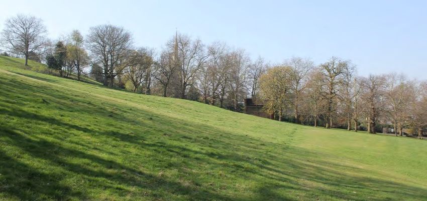
Blackheath pebble beds (Blackheath Member of the Harwich Formation)
The Dell was once a small gravel pit quarrying the rounded black pebbles known informally as
Blackheath pebble beds. There were many such quarries, both within Greenwich Park and beyond
on Blackheath. Most were back-filled with war-time rubble but some became ponds (as in
                                                      Greenwich Park) and three have remained as
                                                      pits: The Dell here and Vanbrugh Pit just to the
                                                      east of the perimeter wall, and Eliot’s Pit on
                                                      Blackheath in the southwest corner. It is the
                                                      nature of the pebbles that gave rise first to the
                                                      name of the plateau and then to the name of the
                                                      village. Usually it is the other way round with the
                                                      place where the stratum was first described that
                                                      gives it the name used by geologists (as in
                                                      Woolwich Formation). Contrary to local myth,
                                                      the name ‘Blackheath’ has nothing to do with
                                                      the Black Death. The pits were probably
                                                      primarily dug for road-mending. Search around
Pebbles of the Blackheath beds                        on bare slopes for the pebbles. They are all
made of flint that had its origin as layers within the White Chalk. After weathering out of cliffs they
must have been transported for a long time to become so evenly rounded, probably by the sea, but
with no input from new material. Sometimes little white pits can be detected where the pebbles
were touching when deposited.

  Portion of 1863-7 OS map showing position of pits within Greenwich Park and on Blackheath

The size of the pebbles implies they were deposited by high-energy currents and it is thought that
in places this has channelled through the underlying strata to form thick sequences. Fossils found
within the sequence inform us that the Blackheath pebble beds were laid down under the sea. The
average thickness on Blackheath and at the top of Greenwich Park is up to 10m but at Abbey Wood
further east it reaches nearly 30m in places. The top surface is always at much the same height, 40-
45m and forms a plateau that extends from Blackheath to Erith, some 13km away. On old maps the
                                                   9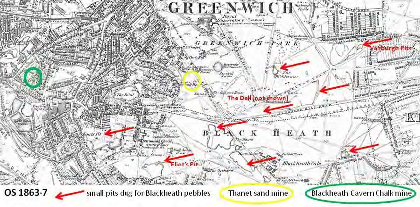
Blackheath beds are shown as the London Clay bottom bed and they are still associated with the
London Clay at the base of the Thames Group. This ‘bottom bed’ equates from strata of a similar
age stretching from Harwich to Reading and has been termed the Harwich Formation – an extremely
variable suite of rocks which includes ash bands in the Harwich area, dating from a time, 55 million
years ago when America was beginning to split away from Europe. Volcanoes on the west coast of
Scotland deposited their ash in Essex and Suffolk where about 30 separate ash layers have been
identified. Elsewhere the Harwich Formation consists of sands and clays, mostly including fossils as
well as the rounded black pebbles we find here.

                            Reconstruction of an Early Eocene Forest.
                    From ‘The Book of Life’ Ed. S.J. Gould 1993. Random House

From the shelly sands of the Lessness Shell Bed at the base of the Blackheath beds at Abbey Wood
further east we learn much about life on land 55 million years ago. Most of the sea shells within the
sands are marine but some our estuarine, similar to the slightly older Woolwich beds in this area.
Sharks teeth are common and much collected but what makes the site important is the small
number of mammal fragments (Hooker, 2010). These are occasionally found when the site is opened
up each year, indicating a close proximity to land and several bear no resemblance to mammals
living today. Others, like the ‘Dawn horse’ are ancestors of groups with which we are more familiar.
There are ape-like animals and early deer, and they lived in a land that was hotter than today with
                                                 10
temperatures similar to Malaysia but fossil seeds indicate there was some seasonality. At that time
Britain lay at the same latitude as Barcelona is today.
Head across Blackheath Avenue past Blackheath Gate to the Lake in the Flower Garden
Stop 4: Lake in former gravel pit (TQ 392 770)
The depression made by a former gravel pit has been put to good use by creating a lake. The
Blackheath pebbles quarried from the pit are discussed at Stop 3 but it is worth mentioning that
other strata in the neighbourhood were considered sufficiently valuable to warrant mining in times
gone past. These are shown on the map accompanying Stop 3.
The nearest is the Thanet Sand, which was mined adjacent to the west perimeter wall of Greenwich
Park more or less in line with the Reservoir shown on the map. A description can be found on the
Subterranean Greenwich website when cavers entered the mine. Access is in Hyde Vale, with stairs
descending about 20 feet to a passageway varying between 4 and 8 feet high and extending about
280 feet (85m). Old descriptions mention a maze of tunnels but none were found when visited by
Subterranean Greenwich. The existing mine was rediscovered in 1986. Nearby at Gilbert’s Pit,
Charlton, Thanet Sand was used for foundry sand in the Woolwich Arsenal and for glass making but
there is no evidence of how the sand from this mine was used.
Investigating the sand mines Image of the Blackheath Chalk Caverns
Source: Subterranean Greenwich website (see reference at end)
A natural exposure of Chalk occurs in the Valley of the Ravensbourne slightly further west. Again,
Subterranean Greenwich can supply some details of chalk mining in the area. Mines were cut back
into Maidenhead Hill and Trinity Grove, known as Blackheath Cavern Chalk mines. Subsidence seems
to have been an on-going problem in the area since their closure. Chalk was used as a lime fertiliser
11on sandy soils and many ancient mines and Dene Holes in the area were used for this purpose. A
map dated 1770 with the purpose of selling land for building states in two places: Digging Chalk x
Burning lime so presumably that was the use to that point. During the 17th and 18th centuries chalk
was needed to mix with London Clay to stop shrinkage in brick-making. It would be nice to think that
the chalk was used for this purpose as it is difficult to track where the chalk that was imported to
north London to mix with London Clay there came from. This is undoubtedly the nearest exposure
and its proximity to the Thames will have eased the cost of transport but there is so far no evidence
to support its export and it seems that this site at least was scheduled for building from an early age.
There is evidence that in the mid-19th century the caverns were no longer operating and had been
turned into pleasure pursuits with a Ballroom and bar. They were forced to close for building
purposes in 1841 and never re-opened.
Head across Bower Avenue with the Bandstand on your right to the Pavilion Tea House
Pavilion Tea House (TQ 390 772)
This is a good stopping off point with large seating area inside and out. Refreshments include hot
food, sandwiches and salads.
The Pavilion Tea House
Continue across Blackheath Avenue towards Observatory entrance and look for the plaque to
Flamsteed’s Well.
12Stop 5: Flamsteed’s Well telescope ‘1676’ (TQ 388 773)
A plaque at the well site, next to the
Observatory, shows an engraving of the well
telescope by Francis Place dated 1676.
It is not known exactly when Flamsteed’s
well was dug but descriptions variously put
the well at 100, 124 or 130 feet deep (40m).
The engraving shows a brick lining about 80
ft deep which seems likely to be penetrating
the Blackheath pebbles and the variable
sands and clays of the Lambeth Group
through to reach the Chalk, which did not
need lining. It is interesting that the image
of Flamsteed lying on his back at the bottom
of the shaft implies that the bottom is dry.
13On returning to Blackheath Avenue, turn left towards the viewpoint with Wolfe’s statue and the
Greenwich Meridian (Stop 6).
Stop 6: Greenwich Meridian (TQ 388 773)
Greenwich is known all over the world as home of the Prime Meridian. But why was Greenwich
chosen for this distinction? The Observatory here was built in 1675 but it took almost a century of
observations and calculations until Neville Maskelyne, the fifth Astronomer Royal, was able to
publish first the Nautical Almanac, from which navigators anywhere in the world could use
observations of the Moon to work out what time it was at Greenwich. This enabled them to get their
Longitude, and it was in use by over 70% of the world’s shipping by 1884 when this Meridian and
Greenwich Mean Time were adopted as international standards. As measurement accuracy
improved with atomic clocks and Earth satellites, it was discovered that the Earth is not a stable
unchanging body. The rotation rate fluctuates, the poles wander and the continental plates drift, all
by measurable amounts. So, a new measurement system had to be devised in the 1960s, the
International Terrestrial Reference Frame, which is defined by the centre of the Earth and the
average positions of all the continental plates. The result is that the ITRF Meridian no longer
coincides precisely with that marked in the Observatory, but is currently 102 metres to the east.
Similarly, Universal Time is allowed to vary by up to 1 second from GMT. These are small differences,
however, and Greenwich is still the home of time and location for reasons of historical continuity.
Head east past the Queen Elizabeth Oak, the fountain at the end of the conduits and another
quarry pit, and up towards One Tree Hill avoiding steps
Stop 7: One Tree Hill (TQ 390 775)
Overview of the geology from this view point
This is a good view point to recap on the local geology and also to look beyond the Park to younger,
higher, strata. The view point is on the edge of the Blackheath Plateau which is here about 2 m thick.
Below, the ground falls steeply away through the variable soft sands and clays of the Lambeth Group
with a break of slope where the junction with the Thanet Sand is met. With such a steep slope it is
not surprising that it has failed from time to time leaving a tumble of mixed material, termed Head
covering much of the Thanet Sand. This has been accumulating for about 20,000 years as the land
warmed up after the most recent ice age. As discussed at Stop 1, close to the Thames the solid strata
are overlain by the Kempton Park Gravel. What is surprising is that the Kempton Park Gravel is
directly overlying Chalk in places (see geology map, Stop 1). In north London Chalk is only
encountered at depth, beneath the deepest of the infra-structure. Here it is brought to the surface
by a fault, or more likely a series of faults to create the Greenwich Anticline whereby rocks have
been pushed up, then eroded, leaving the oldest rocks exposed in the centre of the upfold. The fault-
line runs along the edge of the Park in front but luckily for the iconic buildings behind it there seems
to have been no recent movement. This is why it was possible to mine Chalk close to the surface in
the Greenwich area (see Stop 4).
14View from One Tree Hill towards central London and Hampstead Ridge
Photo: Laurie Baker, September 2020
Current transport projects under London have revealed many more faults than were previously
realised and the ground investigation boreholes have added greatly to what is known about the
structure beneath London. Movement on the faults is the result of Africa colliding with Europe.
Gradually the Mediterranean Sea is closing as the Alps are pushed upwards but the push extends to
Britain and is responsible for the uplift of the Weald to the south of London and the downfold of the
London Basin. Small anticlines such as the ones at Greenwich, Purfleet and Streatham are all
perturbations within this overall downfold.
The far distant hills on the other side of the Thames on a good day, are higher than Greenwich Park
and display younger solid geology. The Blackheath pebble bed beneath your feet at this point
underlies the London Clay which is the surface rock under much of London. On the highest of the
hills the full depth of the London Clay is present, including the sandy layer at the top known as the
Claygate Beds, a maximum of 110m. All of this has been eroded from Greenwich but can be found
not far away on Shooters Hill. The youngest rocks of the solid geology, the Bagshot sands (about 40
million years old) cap the highest of the hills, Hampstead Heath and Harrow-on-the-Hill in the west
and Epping Forest in the east. It is not found on Shooters Hill or Sydenham Hill in south London. It
probably once covered the whole area but over millions of years has been mostly eroded.
15Formation of the Weald Anticline and the London Basin Syncline
After Friend 2008, Fig. 10
It was during the 50-million-year time gap between the deposition of the Bagshot Sands and the
laying down of a series of gravel terraces on either side of the Thames that the earth movements
that caused the present structures happened. During this time Britain ceased to be under the sea
and became land, initially joined to Europe but probably severed by the English Channel at the end
of the most extensive ice age by a vast lake of water that built up from the Thames and the Rhine
with nowhere to go. Eventually the remaining neck of land was broken through and water cascaded
down the English Channel to the Atlantic. The ice sheet reached as far as North London and lakes
built up at the margins. As the ice melted about 400,000 years ago these too burst their banks and
forced the Thames into more or less its current position.
Diversion of the River Thames by the Anglian ice sheet
After Bridgland and Gibbons, 1997
16Head down the steps past a Conduit Head below One Tree Hill and Stop 8
Conduit Head at One Tree Hill, which formed part of Greenwich Park’s water supply network
Photo: Laurie Baker, September 2020
The conduit head is another part of the water supply system which channelled natural groundwater
from the high ground of the Greenwich escarpment, northwards to the buildings of the Royal
Hospital for Seamen (the Old Royal Naval College).
It again dates from the late-17th or early-18th century, and is tentatively attributed to the renowned
architect Nicholas Hawksmoor, Clerk of the Works at Greenwich between 1698 and 1735.
Stop 8: East Coombe (TQ 391 776)
Even though the great Anglian ice sheet did not reach south London, its effects were felt. All the
land in front of the ice sheet would have been frozen permafrost and as it melted a vast amount of
water would have been released. East Coombe in front of you would have been formed in this way.
Since the Anglian ice advance, at its height 450,000 years ago there have been five subsequent
glaciations, but none of the ice sheets reached as far as London. Nevertheless, the same process of
permafrost and melt water would have chiselled away areas where water was flowing, creating the
coombs, or ‘bites in the landscape’ that we see today. With each glaciation the Thames deposited
floodplain sands and gravels which became terraces as the river then down cut further. The one
adjacent to the Thames in Greenwich is the Kempton Park Gravel laid down between 100,000 and
50,000 years ago.
17View from top of east combe towards the Thames showing the effect of past water flows
Photo by Laurie Baker, June 2019
Idealised section through the Thames terrace staircase, with the oldest deposited gravels at the
top. The Kempton Park (Floodplain) Gravel (MIS 5) underlies the National Maritime Museum and
Queen’s House. During each cold period the ground was completely frozen.
18To return to the Thames Path, exit the park by the Park Row Gate and follow the route down Park
Row. Or, for transport connections listed at the beginning, exit via the St. Mary’s Gate at the north-
west corner of the park.
__________________________________________________________
This Geotrail was compiled by Diana Clements, Ann Davidson, Theresa Ball, Paul Rainey, Laurie Baker
and Alister Hayes, June 2019.
References
Bridgland, D.R. & Gibbard, P.L., 1997: Quaternary River Diversion in the London Basin and the
Eastern English Channel. Géographie physique et Quaternaire 51: 337-346.
British Geological Survey 1:50,000 South London Map 270
Clements, D., 2010. The Geology of London, Geologists’ Association Guide No 68 ISBN 978 0900717
90 1
Ellison, R. A., 2004. Geology of London, A special memoir for 1:50,000 Geological sheets 256, 257,
270 and 271. British Geological Survey ISBN 085272478-0
Friend, P., 2008. Southern England: Looking at the Natural Landscapes. Collins New Naturalist
Library ISBN 978-0-00-724743-1 (PB) 978-0-00-724742-4 (HB)
Gould, S.J. 1993. (editor) The Book of Life. Random House
Hooker, Jerry J. 2010. The mammal fauna of the Early Eocene Blackheath Formation of Abbey Wood,
London. Monograph of the Palaeontographical Society, London (Publ. No. 634, in Vol 165): 1-162
Laurie P.S. 1956. Flamsteed’s Well. The Observatory 76:24-5
London Geodiversity Partnership website re GLA 1 (Abbey Wood), GLA 14 (Gilbert’s Pit, Charlton)
and GLA 73 (Greenwich Park): www.londongeopartnership.org.uk/londonguidesites.html
Ordnance Survey 1:2500 map of Greenwich 1893-4. Published by Alan Godfrey Maps sheets 92 and
105 (reprinted by courtesy of The Trustees of the National Library of Scotland).
Schreve, D.C., 2004. The Quaternary mammals of southern and eastern England. Field Guide for
EuroMam UK 2004. London. Quaternary Research Association.
Subterranean Greenwich: The authors have deleted the website but some material can be found if
you put “Subterranean Greenwich” into a search engine such as Google. The Irriplan report of 2009
into the Hyde Vale Conduit, the Underground Reservoir and Conduit House can be found at:
https://www.whatdotheyknow.com/request/subterranean_features_under_greenwich Park, with
the plans at: https://www.whatdotheyknow.com/request/greenwich_park_subterranean_plan
Sugiyama et al.1999. Observations of Ground Movements during Tunnel Construction by Slurry
Shield Method at the Docklands Light Railway Lewisham Extension – East London. Soils and
Foundations 39 No 3. Japanese Geotechnical Society.
Willmot, F. 1969. Flamsteed’s Well, Greenwich. Lewisham Natural History Society. The Kent
Archaeological Review.
19You can also read