GROWING FORWARD - 37 St. GLENDALE ROSSCARROCK WESTGATE - Rosscarrock Community Association
←
→
Page content transcription
If your browser does not render page correctly, please read the page content below

GROWING FORWARD

     Ostap Fedynets                        Taylor Felt   Edward Spink
     Planner                                Planner           Planner
                                               10 Ave

                                 37 St.
                                          GLENDALE
                                                                        Ostap Fedynets
                      FEDYNETS
                                          ROSSCARROCK                       Taylor Felt
                                                                         Edward Spink
                                          WESTGATE
                      FELT

                      SPINK
                      PLANNING + DESIGN
TABLE OF CONTENT
                         Table of Contents

                    2

    Meet our Team                                Community Change

                                             4                                                8

                         Our Process                                     History and People

2
                    10                                              12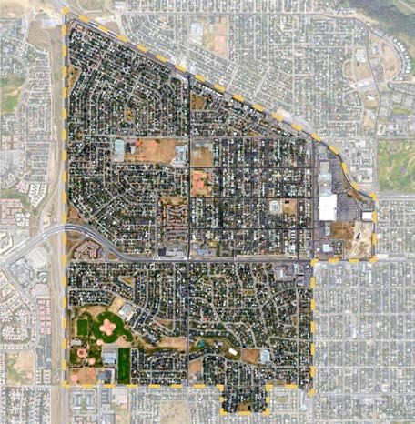
Public Feedback                                   Parks and Open Space

               16                                                 20

Laneway Housing                                     Land Use and Zoning

                                       32                                                34

                        Mobility and Connectivity                         Public Transportation

               54                                                 60

Active Transportation                               References

                                       64                                                76       3
A REGIONAL PERSPECTIVE
    MEET OUR TEAM        FOR COMMUNITY
                         GROWTH
                         Data and experience driven community design.

                         FFS Planning + Design is           With a strong foundation
                         disrupting the planning and        in greenfield and regional
                         design space within Calgary        planning, our boutique firm has
                         by offering clients something      championed innovative design
                         unique: a form-based approach to   solutions for central Calgary’s
                         community and regional planning.   Pumphouse Park, the Spyhill

                    01
                                                            Master Planned community in
                                                            north Calgary, and advised the
                                                            Calgary Metropolitan Regional
                                                            Board in the development of
                                                            a long range regional growth
                                                            management plan. We’re excited
                                                            to leverage that experience
                                                            towards a new community plan.

4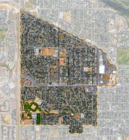
Ostap Fedynets, Planner                                    Taylor Felt, Planner                                    Edward Spink, Planner

Ostap is a second year Master of Planning      Taylor is a second year Master of Planning    Edward is a second year Master of Planning
student at the University of Calgary. With a   student at the University of Calgary. His     student at the University of Calgary. With an
Bachelor in Arts in Philosophy and Human       Bachelor of Arts in Political Science and     undergraduate degree in Biological Scienc-
Geography, he has an interest in planning      Business has created an interest in public    es and Sociology, he is interested in the
environmental interventions from a systems     engagement, policy and planning law. Taylor   intersection between public health, urban
perspective. Ostap brings experience           recently completed a 4-month internship       design, affordable housing, and mobility. As
hand-drawn graphics and planning               with Sustainable Calgary, where he con-       the Environmental Design Students’ Asso-
implementation. In his volunteer work with     ducted a morphological analysis of how to     ciation president, Edward has experience
the Spruce Cliff and Bowness Community         enhance active transportation networks in     with project management and stakeholder
Associations, Ostap has experienced            low-income communities.                       engagement.
managing and commenting on new
developments in established communities,
as well as two forms of the Main Streets
project.                                                                                                                                     5
02
    ABOUT THE
    PROCESS.

6
GLENDALE
ROSSCARROCK     EXPERIENCE CALGARY AS IT
WESTGATE        SHOULD BE.
                                        BO
                                           W
                                               TRA
                                                  IL

                         SARCEE TRAIL
COMPLETE      CONNECTED                  CALCULATED

                                                       45 ST
                                                               7 17 A
                                                                Best
                                                               Great
                                                               Good
                                                                 Fair
                                                                Poor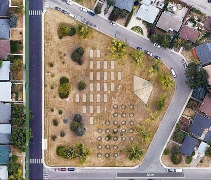
Initial Buildout.
                 12000
                                                        declining population.                     time to choose:
                                                                                                                     WHY DO COMMUNITIES
                                                                                                                     CHANGE?
                 11000
                 10000
                  9000
                  8000
                 7000
                 6000                                                                                                It’s time for the neighbourhood to make a choice: stay the
                 5000                                                                                                course or revitalize.
    population

                 4000
                 3000
                 2000
                                                                                                                      This is a model for the way         dwindle.
                 1000
                                                                                                                      communities rise, fall and
                     1948          1958   1968          1978         1988    1998          2008    2018     2028      revitalize which has been
                                                                                                                    2038
                                                                                                                                                          The businesses begin to struggle
                            sum total     Glendale             westgate      rosscarrock
                            -2465 - 21%   -1156 - 30%          -1150 - 27%   -159   - 4%                              supported by both real world        as their customer base shrinks.
                                                                                                                      cases and the literature.           A choice has to be made.

                                                                                                                     “As the initial stages of a new      Option 1: Stay the Course
                                                                                                                     development near completion,         The first sign of decline is
                                                                                                                     the first buyers begin to move in.   when the school shuts down.
                                                                                                                     Typically, these first residents     With enrollment dropping, the
                                                                                                                     are young families or young          neighborhood kids are diverted
                                                                                                                     couples planning to start a          into a new school in one of the
                                                                                                                     family. Over the first twelve        nearby communities.
                                                                                                                     years the houses and streets
                                                                                                                     begin to take shape and the          Option 2: Revitalize
                                                                                                                     first children begin to grow up.     The first sign of change is when
                                                                                                                     The neighborhood will reach its      a couple of residents subdivide
                                                                                                                     peak population at the end of its    their lots. Developers buy a
                                                                                                                     second decade. Over the next         number of lots and convert
                                                                                                                     sixteen years, the neighborhood      them to row houses. The streets
                                                                                                                     kids start to trickle out.           come alive, the schools fill back
                                                                                                                                                          up, and businesses once again
                                                                                                                     With the kids gone, and no           thrive” (City of Edmonton, Infill
                                                                                                                     new homes available for young        Roadmap 2018).
8                                                                                                                    families to take their place, the
                                                                                                                     numbers in the schools start to
DRIVERS OF CHANGE
                    Time                         Lifecycle                    Finance

                    After a lengthy engagement the City has determined that 50% of
                    future population growth should be housed in the existing Calgary
                    footprint, with most this in already established areas. This is
                    partially due to the constraints placed upon municipal finance by
                    increasing low density development to the exterior. These modes of
                    development simply do not generate enough tax revenue to pay for
                    themselves and must currently be subsidized by the downtown core.

                    LRT                        Engagement               Demographics

                    The massive investment of the LRT demands an increase in
                    ridership and is very attractive to downtown workers, triggering
                    redevelopment pressure. The diverse populations demands a variety    9
                    of housing and transportation options.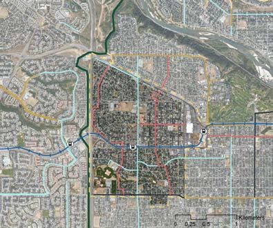
THE COMMUNITY
     DESIGN PROCESS.
     The Stages and Steps of Established Area Planning

     This section illustrates an         Next, we explore the natural
     abbreviated explanation of our      and historical context of the
     Community Design process. Our       three communities, tracking
     firm sees these phases as vital     environmental data, growth rates
     components of any successful        and housing change.
     plan. It should be noted that
     this process is not necessarily     We explore stakeholder opinions
     linear - the design stage reveals   on growth and change in order
     information gaps which then         to shape the initial design, and
     demand further analysis.            display a draft design for review
                                         and feedback.
     A review of the legal framework
     will provide constraints for the    Finally, we provide our
     design and ensure that the          completed community
     project aligns with the hierarchy   recommendations via
     of plans.                           presentation and report.

10
1 2 3 4 Community Associations City of Calgary Businesses Current and Future Residents As our project involves The City has a vested interest Businesses in the area would like Current residents are a diverse partnering with the Federation in seeing a more financially to see a larger customer base, group, a range in median of Calgary Communities, the and socially sustainable form better access to their locations income, housing tenure, age, community associations of of development, and more via active transportation and less ethnicity and occupation. The Glendale, Rrosscarrock and ridership for the two area LRT restrictive City land regulations. plan will address current needs 11 Westgate are the main client. Stations. and respond to the future.
03
              COMMUNITY
              CONTEXT.

     1911                                1949                               1964                            1966

     Rosscarrock - the Tregillus ranch   West Calgary “ Country Resident”   The #8 Killarney trolley bus    Westbrook Mall opens (1964),
12   house, located at 37th Ave. and     prior to annexation for future     reached 45th St. SW and 17th.   including a branch of the Calgary
     Bow Trail.                          community development.             Ave.                            Public Library.
THE HISTORY
OF PEOPLE AND PLACE
“Calgarians . . . would fail ignominiously in their
duty did they not look at least a hundred years
ahead.”
William John Tregillus in the Morning Albertan (1911)
1982 2007 2012 2019
7th Ave. Drive-In transitions Ernest Manning School Calgary’s first underground LRT Area sees infrastructure im-
to Westgate Heritage Manor demolished and construction of Station is complete. provements along 17th Ave, 37 13
Housing Coop Ltd, development Westbrook Station begins. St. and a new pedestrian over-
increases along 17th Ave. pass across Bow Trail.The majority of Westgate rest, the difference in form is
DEMOGRAPHIC and Glendale’s housing stock
is still from the 1950s while
unsurprising. While Glendale
and Westgate are mostly
Rosscarrock has significantly Bungalows, Rosscarrock has a
ANALYSIS renewed. The age of housing is
closely related to the population
variety of housing types and a
large amount of 1.5 storey up-
fall. This map also highlights a down duplexes. As expected,
few potentially historic homes this redevelopment has not
in the area. Given this age gap resulted in lowered property
Ageing homes on high value land.
between Rosscarrock and the value.
Building Age Property Value
0 - 1919
1920 - 1929
1930 - 1939
1940 - 1949
1950 - 1959
1960 - 1969
1970 - 1979
1980 - 1989
1990 - 1999
2000 - 2009
2010 - 2018
No Data
$74 500 - $399 999
$400 000 - $699 999
$700 000 - $899 999
$900 000+
14 0 0.125 0.25
KM
0.5 KM
0 0.125 0.25 0.5g value e change
llin 598K alu +30%
3 COMMUNITIES. we g v
d
glendale glendale
lin
an
dwel
551K +29%
Medi
3 DIFFERENT rosscarrock rosscarrock
2011-2016
2016
550k +28%
westgate
STORIES.
westgate
450K +7%
Calgary calgary
k
oc
rr
Westgate and Glendale are largely homogeneous in form and s
ca
22
.4
population. Rosscarrock is younger, poorer and has less families. Age and Income
s
gl
ro
en
ld
da
e eho
Unsurprisingly, the communities account for the younger age.
le
32
siz ous
20 016
11
2
experiencing most of the popu- Calgary, which is on average When looked at more closely,
h
3
2
.6
we
. 4
lation drop are the oldest. Also only two years older - earns $35 the lowest earners seem to be
st
t 2
.6
connected to age are median 000 more. All communities have . leaving the communities. It’s
ga
26
incomes. The younger crowd in experienced serious income likely that the second highest
y
e
yc
Rosscarrock has a significantly growth in the last 8 years. This wage group is moving farther
lower income, even if we do has not kept pace with housing out where they can get more
cost rise. square footage for their money
old income n Age - while the top income owner
eh come growth Media population is growing.
us 107K in +28% y 39
t
glendale Westgate
o
uni
Westgate
old
On the age side we see a
nh
100K 39
comm
househ
+23%
Media
huge rise in millenials, which
Calgary calgary Glendale
corresponds to the large
37
2016
98k +18% increase in rental distribution.
2016
016
westgate scarrock calgary And the population of kids is
2011-2
ros
65K +16% 35 only rising in Rosscarrock, again
showing that it’s attracting
rosscarrock Glendale rosscarrock young executive couples. 15COMMUNITY
04
FEEDBACK.
16ENGAGEMENT PROCESS
AND TIMELINE.
An inclusive and responsive planning process.
Public engagement is a vital way for residents to share their
portion of any community day to day experiences with the
planning process. Residents, team.
business owners and developers
have unique knowledge of the It also isn’t a commandment
areas strengths, weaknesses, or proclamation. At FSS we
threats and opportunities. allow our team to use their
This information provides education and unique planning
our planners with additional experiences to make evidence-
considerations they have to take based choices and designs.
into account in order to create a Community residents will be
successful plan. heard and their concerns will be
noted. Should the plan need to
At FFS Planning + Design, move in a another direction, this
engagement is not a check-the- change will be explained.
box activity. It is a meaningful
PHASE 1 PHASE 2 PHASE 3 PHASE 4 PHASE 5 PHASE 6
Background Analysis Engagement Design Design Review Final Report
Engagement! Engagement! Engagement!
Focus Groups
Jan. 28
Workshop
March 2
Open House
April 13 17COMMUNITY IDENTIFIED denser streets
amenities
access
westbrook Mall
Shared use Path
proximity
mass transit
parking
OPPORTUNITY
amenities
18
cycling routesCOMMUNITY IDENTIFIED affordability
perception
housing stock
rec centres
infrastructure
park ‘n ride
barriers
safety
CONSTRAINT
Schools
traffic volume 19ENVIRONMENT
Outdoor Rink, Glendale Community Association, Calgary
ENVIRONMENT, PARKS &
05
OPEN SPACE
Re-imagining connected parks and open spaces that are exciting
destinations for everyone in the community.
Glendale, Rosscarrock, and now is the time to enhance these
Westgate, are situated at the green spaces, improved active
center of a triangulation of parks transportation connections,
and open space. This includes and invest in diversifying and
regional parks, Optimist Athletic improving the urban forest
Park, and neighborhood parks. for the current and futures
20 Douglas Fir Trail, Edworthy Park, Calgary As pressure for redevelopment residents who will call these
increases in the communities, communities their home.1 2 3 4
Open Space Plan Developed Areas Guidebook Tree Protection Plan Urban Forest Managment
The Open Space Plan is a non- One of three guidebooks The purpose of the Tree The City of Calgary provides a
statutory policy document that that are part of the Municipal Protection Plan is to prevent comprehensive database of geo-
outlines the general framework Development Plan, the DAG sets damage to public trees caused referenced public and private
and broad policies regarding a broad policies to be followed by development work on, near, tree species that make up the
open space in the City of when creating high quality, or crossing City property. city’s urban forest: https://maps.
Calgary. connected, parks and open calgary.ca/TreeSchedule/ 21
spaces in Local Area Plans.CONNECTING PARKS AND
EDWORTHY
PARK
GREEN SPACE.
LOWERY
GARDENS
Tying into an area well serviced by regional parks and open space.
The Mattamy Greenway is a The communities are serviced
multi-use pathway running by many regional, community,
parallel to Sarcee Trail on neighborhood, special purpose SHAGANAPPI
the west side of Glendale (such as Optimist Athletic Park POINT GOLF
and Westgate. The Greenway and Shaganappi Point Golf
COURSE
provides a connection to Course), and subneighbourhood
Edworthy Park, a regional parks (referred to as ‘pocket
destination for families to parks’ by the communities).
OPTIMIST
recreate, the Bow River Pathway Through our engagement
and the Lowery Gardens. The session and observations
PARK
Bow River Pathway runs along within the community, we
the south bank of the Bow found that many of these parks
River and ultimately connects are disconnected and often
to downtown Calgary. Many underutilized. The objective
members of the communities of FFS Planning and Design
consider the pathway as a safe is twofold, to first create a
and efficient way to cycle to connected parks and open space Q. What are the outside
work. The Lowery Gardens are concept through a network of
connected by the ecologically green corridors that encourages resources and amenities your
significant Douglas Fir Trail to
Shaganappi Point Golf Course.
active transportation (walking
and cycling) and secondly to community should connect to?
Despite being a public golf program these spaces in a
course, owned and operated by way that draws people back to
the City of Calgary, Shaganappi these places, all year round. By A. Edworthy Park and Shaganappi
Point is a popular destination for addressing these two issues we
community members to enjoy can create active and vibrant Golf Course!
22 free access to cross-country parks for all Calgarians to enjoy.
skiing in the winter.THE URBAN FORREST.
FILLING THE GAPS.
2
The urban forest does not just GIS, a spatial analysis tool, we were
contribute aesthetic value to able to generate a map determining
1 the urban landscape, but also where there are gaps (trees more
provides other countless benefits than 6m apart) within the urban
and ecological services. Trees forest to direct tree planting
improve air quality, offer visual initiatives. The City of Calgary
and auditory screening, retain recommends planting street trees
storm water, provide shade, no closer than 6M apart to ensure
and create safer pedestrian and a tree’s roots are not overcrowded
cycling environments within the and competing for resources.
community. Our strategy is to On the following page, (1) 40th
connect the parks and open spaces Street SW., has a low number
across the communities through a of public street trees, an overall
network of green corridors. comment on the density of trees in
Rosscarrock. Our team has curated
Our initial analysis examined the a list of species that are resilient
existing tree coverage across to Calgary’s short and dry growing
the three communities. In doing conditions, that are not impacted
Trees 6m this, we found that Rosscarrock by chinooks, and are tolerant to the
currently has less than half the hardy conditions of urban street
number of trees as Glendale. Using life, such as salt and pollution.
23SHADE
Brandon Elm Dropmore Linden Balsam Poplar Trembling Aspen Birch 1
Ulmus americana Tilia x flavescens Populus balsamifera Populus Tremuloides Betula papyrifera
‘Brandon” ‘Dropmore’
FLOWERING
FRUIT AND
40th Street SW., Calgary,
Crabapple Ussurian Pear Mayday Princess Kay Plum
Malus Pyrus ussuriensis Prunus pradus var Prunus nigra ‘Princess Kay’
commutata 2
CONIFEROUS
7th Ave. SW., Rosscarrock, Calgary,
Tamarack Norway Colorado
Latrix laricina Spruce Spruce
Green spaces need to be more
diverse and higher quality -
SHRUBS
not just grass but also trees,
Meye’s Dwarf Lilac Prickly Rose Saskatoon Potentilla
Syringa meyerii “Palibin” Rosa acicularis Amelanchier alnifolia Potentilla food trees, shrubs, furniture
and interesting landscaping.
- member of the community
GRASSES
(March 4th, 2019, community workshop)
Moor Grass Blue Fescue Rough Fescue
Molina caerulea Festuca ovina glauca Festuca campestris
https://www.calgaryplants.com/collections/trees
INVASIVE
24
SPECIES
https://www.calgarytrees.ca
http://www.insideeducation.ca/wp-content/uploads/2014/10/TreeShrub.pdf
https://www1.calgary.ca/CSPS/Parks/Documents/Planning-and-Operations/Tree-Management/landscape-specs-trees.
Creeping Bellflower Yellow Cematis Wild Caraway pdf
Syringa meyerii “Palibin” Clematis tangutica Carum carviGREEN
CORRIDORS.
Connecting green spaces with active green corridors.
In conjunction with the coupled with a designated bike
recommended street tree lane. Spanning the entire length
replanting initiative, FFS of the communities, connecting
is proposing greening the Optimist Athletic Park and the
communities through a series Glendale Community Centre,
of connected green corridors. to the 45 Street Station LRT,
These corridors would seek the Rosscarrock Community
Bike Fa- to layer high-quality active Association, and three school
Protected Bike Lane transportation infrastructure sites, 45th Street will act as
Painted Bike Lane with a targeted street tree the main arterial for the green
Shared Bike Lane planting program along 45th corridor network. With 13th
Mattamy Greenway street, 8th avenue, 13th avenue, Avenue, 8th Avenue, and
Green Corridors Westwood Drive, and Spruce Westwood drive, feeding into 45
Drive (located outside the focus Street, the network will provide
communities) to complete a greater and safer access to the
connected parks and open space communities’ parks and open
network. The selected corridors spaces.
will be planted with species from
the recommended tree palette,
45th Street kissing canopy 25
Urban Tree Canopy - 8th Street NE. Calgary, AB.ENHANCE THE PARKS
AND OPEN SPACE
THROUGH ACTIVE
PROGRAMING.
Drawing the People Back to the Parks.
Our team created a palette (right) to aid the
communities in implementing improvements to their
parks and open spaces with the intention of drawing
people back outside and building community. Each
number on the adjacent map correlates with an
improvement item on the palette. Overall, many of the
pocket parks require basic urban furniture to provide
visitors with a place to rest and dispose of their waste.
Additionally, FFS prioritized programming and activating
the parks connected to the proposed 45th Avenue green
26 corridor. The following pages we will illustrate our firm’s
vision for the 3 selected parks outlines in red.PARKS PROGRAMING
PALETTE.
1 2 3 4
Urban Furniture
LED Lighting - University of Waste & Recycling Receptacles - Seating - Brooklyn Bridge Park, Bike storage - Cleveland, OH
Calgary Bryan Park, NY
5 6 7
Vegetation
Community Gardens - Parkdale, Xeriscaping - Osgood Public Urban Forest - 9the Ave. NE,
Calgary, AB Garden, ON Calgary, AB
8 9 10 11 12
Activities
Outdoor Fitness Pavillion - Rice Accessible Play - Shouldice Natural Playground - Mills Park, Spray Park - Shrewbury, UK Outdoor Curling Rink - Beltline,
University, Houston, TX Park, Calgary, AB Calgary, AB Calgary, AB
13 14 15 16 17
Special
Community Oven Pavillion - Pump Park - Edson, AB Dog Park, Agility Course - East Artisan Gallery - Bow Valley Disc Golf - Brundage Mountain,
27
Vermilion, AB Village, Calgary, AB Ranche, Calgary, AB1
2
Community Oven
Apple Orchard 3
4
Bus Shelter Community Gardens North Productive Park
Bring the community together
with food! This park was re-
imagined with raised garden
28 boxes, an apple orchard, and a
7 6 5 community oven.Agility Course Splash Pad Fenced Dog Run Central Bark Park
Currently, the communities are not serviced
by a dog park. The nearest designated dog
parks are located at the Edworthy Off Leash
Park and the Strathcona Park Off Leash
1 3 5 Area. From our analysis, observations, and
feedback gathered from the community, the
desire for a space that owners can recreate
with dogs was clear. Our proposal suggests
incorporating an urban dog park in the
space directly north of the West Heritage
Manor Housing Coop. The park will feature
an agility course, an off leash run, splash
2 4 6 pad, and spaces for owners to rest and relax.
Seating Area
7
Rest Area 8
29Movie in the Park 1
Seated Lookout
2
Disc Golf 3
Multi-use Pathway
30
4Turtle Hill Improvements
To enhance connectivity, FFS recommends removing the
chain-link fence on the west end of the park bordering
Optimist Athletic Park and connecting the area with a
multi-use pathway. Programming the space with low
impact activities such as a disc golf course will draw
more activity to the park.
Curling 5
Bioswale 6
31
7BO
LANEWAY HOUSING.
W
ROAD
SARCEE
ROAD
0m 4m
80
LANE
LANE
Amenity Space: the minimum Parking: At a minimum, there
17 AVE allowable distance between must be 1 parking stall for the
the primary dwelling and the LWH and 1 parking stall for the
BYS must be no less than main dwelling. We recommend
37 ST
4m. Upper level decks should directing parking to the rear of
0m orient towards the laneway the property and do not encour-
80
and include a visual screen to age on street parking.
residential lane protect neighbours privacy.
26 AVE
LRT
ROAD
Our vision is to offer diverse and affordable housing choices in the ROAD
communities through a backyard suite (BYS) strategy. Our vision
is influence by the MCDA (pictured above) that indicated the most
suitable land for redevelopment is within 800m of an LRT station.
This also offers an opportunity to live a convenient and accessible
lifestyle without a car. In supporting incremental change and gentle LANE
LANE
density throughout the communities, FFS recommends that BYS be
a permitted use in RC-1, R-C2, R-C1s, and R-CG designations, within
800m of LRT stations. Outside the 800m radius of an LRT station, Height & Massing: the BYS must Access: the BYS must abide by
FFS recommends BYS be a discretionary use. Backyard suites within not be taller than the primary the minimum setbacks assigned
800m of an LRT station will not be required to meet the parking dwelling. Upper levels must not to the main dwelling: 1.2m from
minimum of 1 designated stall per BYS. Suites must have direct exceed 60% of the footprint of the side property lines, and
access to a back lane or back lane and side street. There must not the BYS. Suites must include a 1.2m from the rear property
32 be more than one suite located on a property. The following page main living space (living room line. This provides a pathway in
outlines our recommendations for backyard suites guidelines. and/or kitchen) on the ground the event of a fire.
floor.1. Lighting 2. Vegetation 3. Amenity Space
Sides of the suite facing the lane must include Owners should preserve existing trees on their lots Suites should include outdoor amenity space in the
exterior lighting, such as a porch light. To prevent when considering a BYS. At a minimum, 1 of the backyard and/or an upper level deck. Upper level
light pollution, lighting should be directed downward. following must be included in the BYS landscaping: decks must face the rear lane and include a screen or
Consider ground lighting and LED solar garden lights a shrub, tree, hanging baskets or garden boxes. blind to protect neighbours privacy.
as a way to illuminate the lane and increase safety at Vegetation adds character and creates a vibrant
night. laneway. Take this as an opportunity to transform the
laneway into an attractive place.
4. Parking 5. ‘Lane’scaping 5. Overlook
1 parking space must be provided for the primary Including landscaping and additional lighting into your Main floors must include at least one window facing
dwelling and 1 for the BYS, for a total of two parking laneway home can transform the lane into an inviting the lane. The bottom of additional windows located
spaces on the property. Suites that are located within and activated space. Consider permeable paving along the sides of the suite must be located 2 meters
800m of an LRT station do not require a parking space where possible. from the ground, this will allow sunlight in and protect
for the backyard suite. Living in close proximity to neighbours privacy. 33
primary transit offers an affordable alternative to
owning and maintaining a car.Initial Buildout. declining population. time to choose:
12000
11000
10000
9000
8000
7000
6000
5000
population
4000
3000
2000
1000
1948 1958 1968 1978 1988 1998 2008 2018 2028 2038
sum total Glendale westgate rosscarrock
LAND USE
-2465 - 21% -1156 - 30% -1150 - 27% -159 - 4%
WHY CHANGE
ANYTHING AT ALL?
06
Established communities are a dynamic landscape.
Glendale, Rosscarrock and These factors, coupled with the
Westgate began their initial build close proximity to downtown,
out in the mid to late 1950s. has resulted in significant
Since then their population has redevelopment pressure.
risen, and as young families Redevelopment is a complex
turn to empty nesters, has process. Unlike greenfield
declined. While the housing forms development there are multiple
reflect the original residents, existing stakeholders that need
changing national and municipal to be balanced and an existing
34 demographics no longer policy landscape that needs to be
accurately mirror the community. analyzed and responded to.amended december 2005
Developed Areas
Guidebook
pOlicy Guidelines
Westbrook Village Area Redevelopment Plan
TransiT OrienTed
Municipal Development Plan: Volume 2, Part 3
develOpmenT
call 3-1-1
calgary.ca
MUNICIPAL DEVELOPED TRANSIT-ORIENTED WESTBROOK VILLAGE
DEVELOPMENT AREAS DEVELOPMENT REDEVELOPMENT
PLAN GUIDEBOOK GUIDELINES PLAN
Policy Considerations for Glendale, Rosscarrock and Westgate:
The Municipal Development This document outlines the goals TOD is a regional solution Westbrook Station, as the only
Plan is Calgary’s long term for filling in Calgary’s established addressing the financial, social underground LRT station in
vision for growth. It sets a 50/50 communities. 17th Ave. and and environmental problems Calgary in an established, high
split between new and existing 37th St. fall into it the Corridor of increasingly spread out amenity area, represents the
communities as a response to classification as designated Main urban development. These are highest potential TOD site in
population growth. Some of this Streets and are therefore required guidelines for housing types and Calgary. This ARP plans for a high
growth will be accommodated by to intensify as part of the overall commercial uses around LRT rise urban form just south of the
urban corridor intensification. municipal strategy. stations. LRT with TOD conditions. 35CURRENT ZONING
WHERE DO WE DIRECT
BO
W
TR A
REDEVELOPMENT
IL
PRESSURE?
SARCEE TRAIL
Policy provides the direction while data directs outcomes.
45 ST
After exploring the relevant community redevelopment
policy documents, our team Suitbaility Map.
decided to undergo a more
quantifiable community design This map then goesC-COR1
on to shape
process. While organic planning our proposed residential and
C-COR2
! is strong in terms of flexibility, commercial zoning changes,
! it was deccided that data driven C-N1in
our policy considerations
17 AVE
design would allow for a clearer terms of parking relaxations
C-O and
connection between site analysis community amenity bonusing,
and proposed solutions. as well as our laneway DC
housing
strategy. R-C1
For this process, our team
leveraged its spatial analysis R-C1s
experience in ArcMap software C-COR1 R-C2
and conducted a Multi-Criteria
Decision Analysis. This results
C-COR2 R-CG
26 AVE
in a map which combines the C-N1 M-CG
assigned considerations into one C-O M-C1
values map, generally showing a
N
spatial hierarchy. We combined DC M-C2
KM current community planning R-C1 MU-1
36 0 0.125 0.25 0.5
best practices and current
municipal policy to create a R-C1s MU-2
R-C2 S-CS
R-CG S-R
M-CG S-SPR
M-C1 S-CRIDEVELOPMENT SUITABILITY 01 BO
W
TRA
IL 02
BO
SARCEE TRAIL
W
10 min
min
10
TRA 10 min
7 min
IL
45 ST
Current Zoning
5 min
7 min
LRT Proximity
5 min
Westbrook LRT
!
! ! 45 Street LRT
! !
17 AVE
SARCEE TRAIL
26 AVE
N
KM
0 0.125 0.25 0.5 KM
0 0.125 0.25 0.5
Current Zoning (5%) and LRT Proximity (45%)
Land use amendments are an expensive and sometimes contentious
process. Zoning however is generally flexible so this category
received the lowest weighting. LRT proximity received the highest as
proximity to this resource is a major factor influencing use, form and
density, and response to policy.
45 ST
03 04 BO
W
TRA
IL
17 AVE
Property Value
Corridor Proximity
37 ST
Best !
Great !
!
17 AVE
Good $75K - $399K
$400K - $699K
$700K - $899K
Fair $900K+
Poor
KM
0 0.125 0.25 0.5 KM
0 0.125 0.25 0.5
Property Value (35%) and Corridor Proximity (15%)
26 AVE
In accounting for property value, the MCDA accounts for the
difficulty of land acquisition in development, and acts as a proxy for
parcel size. Larger parcels are more attractive for redevelopment. As
designated Main Streets 37th St. and 17th Ave SW are targetted by 37
policy documents for increased density and public realm investment.PROPOSED REZONING
R-C1
BO
W
TRA
WHAT URBAN FORM DO
WE WANT?
R-C1 IL
SARCEE TRAIL
R-C2
Growing up, not out.
45 ST
R-C1
As the MCDA identifies the buildings on the outskirts of the
greatest development potential communities.
within a 5 minute walk of the
! LRT Stations in theC-COR1
communities, Residents also maintained that
as well as along 17th and 37th, heights of 3-5 stories were
C-COR2
! these are the areas which will acceptable in these areas.
! C-N1
need to accept the majority From a complete community
17 AVE
of the density increases.
C-OThis perspective, these responses
is also echoed throughout delegate an urban form that
our public enagagement, DC provides a mix of uses, housing
37 ST
R-C1
where current resdients
R-C1noted and transportation choice
much more support for taller in close proximity to the LRT
R-C1s Stations.
R-C2
C-COR1 R-C2
For this purpose, zoning these
C-COR2 R-CG sites MU-2, MU-1 and MC-2
C-N1 M-CG largely achieves an urban form
C-O that responds to policy, public
M-C1
feedback, demographic analysis.
R-C1 R-C2
N DC M-C2 This would result in mixed use
R-C1 MU-1 buildings of 4-6 storeys directly
38
KM
0 0.125 0.25 0.5 beside the 45 Street LRT Station,
R-C1s MU-2 and taller beside Westbrook.
R-C2 S-CS
R-CG S-R
M-CG S-SPR
M-C1 S-CRIR-C1 R-C1 R-C1
BO BO BO
W W W
TRA TRA TRA
R-C1 IL R-C1 IL R-C1 IL
SARCEE TRAIL
SARCEE TRAIL
SARCEE TRAIL
R-C2 R-C2 R-C2
min
10
45 ST
45 ST
45 ST
R-C1 R-C1 R-C1
7 mi
n
5m
in
! ! !
! ! !
! ! !
17 AVE 17 AVE 17 AVE
37 ST
37 ST
37 ST
R-C1 R-C1 R-C1
R-C2 R-C2 R-C2
26 AVE 26 AVE 26 AVE
N R-C1 R-C2
N N
R-C1 R-C2 R-C1 R-C2
KM KM KM
0 0.125 0.25 0.5 0 0.125 0.25 0.5 0 0.125 0.25 0.5
1 2 3 4
Low Density Residential Neighbourhood Station Area Town Center Station Area Laneway Housing Overlay
In order to keep the To create a vibrant, complete We aim to create a more transit Increasing the population
suburban character of these community and capitalize on supporting community around can also be done through
neighbourhoods alive, the the LRT, a smaller scale TOD has Uptown at Westbrook. The goal encouraging more backyard
majority of the new zoning been zoned around 45th Street is to add to its consumer base suites. This allows existing
maintains the existing RC-1 LRT Station. This precinct also and contribute to LRT system owners to age in place and 39
designation in the community extends along 17th Ave. ridership. capitalize on value increases.
interior.Low Density Residential Housing Typology
Currently housing in the communities is largely 1960s era 1.5 storey
Bungalows or new skinny infill homes. This low variety does not
accurately respond to area demands or demographics. An increased
supply of fourplexes and row houses will move new options from the
$800k+ pricepoint to $450k+. This matches median incomes.
rc-1 rc-2 rC-G
RC-1 RC-2
Neighbourhood Station Area Housing Typology
Mc-G mc-1 mc-2 rc-1 rc-2 rC-G
Moving from the automobile supported low density typologies, these
medium density forms are currently poorly connected and scarce.
Closely connected to transit by active transportation infrastructure,
they’ll include purpose built rental to mitigate gentrification and
allow some residents to age in place.
Mc-G mc-1 mc-2
40 MC-1 CCOR-2DC
Mu-1 mu-2Mc-G mc-1 mc-2 Town Center Station Area Housing Typology
This area represents a novelty in Calgary. In accordance with the
aggressive TOD conditions attached, the Uptown at Westbrook
concept is focused on maximal transit use. Major parking minimum
relxatations and confirmed active transportation investments along
37th will support a lively mixed use live, work, play precinct.
Mu-1 mu-2 DC
DC MU-2
Laneway Housing
While our land use strategy does place most of the higher density redevelopment along Main Streets and in close proximity to the LRT,
the interiors of the 3 communities will also need modest intensification strategies that will allow for expanded housing options. Lane-way
housing, also known as garden and backyard suites accomplishes this purpose and mitigates the parking concerns that come with basement
secondary suites. Our team has developed a comprehensive guideline which covers design, form and distribution.
41R-C1
LOW DENSITY
BO
W
TR A
RESIDENTIAL
PRECINCT
R-C1 IL
SARCEE TRAIL
R-C2
Maintaining community character while providing more options.
45 ST
R-C1
While additional density has experiencing significant
largely been moved to the redevelopment pressure at
exterior, community interiors its northern edge, with a large
! require specific strategies in number of RC-1 toC-COR1
RC-2 re-
order to create a complete designations.
community. C-COR2
!
! The block structure ofC-N1
17 AVE This precinct allows for the Rosscarrock allows for
C-O
maintenance of a low density much easier redevelopment
housing pattern, but expands integration, and is whereDC
the
37 ST
the housing options available. most intense redevelopment
R-C1 is
R-C1
This will likely have positive currently taking place.
affordability and community R-C1s
R-C2 renewal benefits, and further C-COR1 R-C2
improve the consumer base
for businesses. While low C-COR2 R-CG
26 AVE school enrollment is a current C-N1 M-CG
challenge, these housing forms
C-O M-C1
are attractive to families and
R-C1 R-C2
N are therefore a response to that DC M-C2
challenge. R-C1 MU-1
42 0 0.125 0.25
KM
0.5
Currently, Westgate is R-C1s MU-2
R-C2 S-CS
R-CG S-R
M-CG S-SPR
M-C1R-C1
R-C1
01 02 BO
W
BO TR A
W R-C1 IL
TRA
R-C1 R-C1 IL
SARCEE TRAIL
R-C2
1
SARCEE TRAIL
R-C1 R-C2
2
BO
W
TRA 8 AVE
R-C1 IL
45 ST
R-C1
BO
1
SARCEE TRAIL
R-C2
W
45 ST
R-C1
TR A
R-C1 IL R-C1
BO
Double Trouble and Row House Row W
TRA !
R-C1 IL
2
SARCEE TRAIL
R-C2
!
45 ST
SARCEE TRAIL
R-C2
! !
17 AVE
R-C1 Our plan recommends rezoning Westgate north of 8th Ave and west
of 45th St to RC-2 as currently 40% of parcels have already been
3 !
rezoned from RC-1. We envision
! a Row House lined8 AVE corridor for 8th
37 ST
Ave given its proximity to schools,
R-C1
greenspace and use for17 AVE
cycling.
45 ST
R-C1
!
45 ST
R-C2
03 04
37 ST
R-C1
! R-C1
!
! 26 AVE
17 AVE
3 !
!
R-C2
4 R-C1 R-C2 17 AVEN
37 ST
R-C1 26 AVE 4 0 0.125 0.25 0
!
37 ST
R-C1
R-C2
R-C1 R-C2
N R-C
!
! KM
26 AVE 17 AVE 0
Around the Corner and Main Street Transition 26 AVE
0.125 0.25 0.5
R-C1 R-C2
N
R-C1 R-C2
N The pedestrian scaled blocks in Rosscarrock should allow for more
37 ST
affordable density, and permit row houses on all corner parcels. To 0 0.125 0.25
R-C1 0 0.125 0.25
KM
0.5 buffer the density of 17th Ave, 3 storey fourplexes and row houses 43
would create a gradient from the 4 storey multifamily homes.
R-C2POLICY:
LOW DENSITY Parking and Commercial Uses
RESIDENTIAL 8. Where highlighted within the
Low Density Residential Precinct
Map, commercial land uses shall
have no parking minimum in
order to encourage community
pedestrian use.
9. Neighborhood scale
The aim of these policies is to provide more housing options, the front facade of the house. commercial uses shall have a
modestly increase density and preserve character. sales area not greater than 1800
4. In the Row House Row Area, square feet and shall provide
1. Land use re-designations must 2. In no case where a parcel has front setbacks shall be limited to an indoor or outdoor non-sales
be consistent with the zoning lane-way access shall a front a maximum of 2 meters in order area of no less than 400 square
classifications identified on the drive garage be permitted. to create a closer street wall. feet.
Low Density Residential Precinct
Map. 3. In no case shall a front drive 5. Where a building with an 10. If an RC-G parcel is within
garage extend beyond the front existing front driveway is being 400m (as the crow flys) of an
facade of the house. front redeveloped, the driveway shall LRT Station Entrance or 200m
not be retained on lots with rear of a shared use or protected
lane access. cycling path, the parcel shall
be provided a 50% parking
6. Any parcel zoned RC-2 with relaxation.
two existing up-down units shall
have Row Houses as a permitted 11. 10. If an RC-G parcel is within
use, provided the parcel has rear 800m (as the crow flys) of an
lane access. LRT Station Entrance or 400m
of a shared use or protected
7. Main Street Transition cycling path, the parcel shall
shall provide landscaped be provided a 25% parking
44 underground parking access relaxation.
through the lane.45
R-C1
NEIGHBOURHOOD
BO
W
TR A
STATION AREA
PRECINCT
R-C1 IL
SARCEE TRAIL
R-C2
min
10
A smaller scale Transit Oriented Development.
45 ST
R-C1
7 mi
n
This area represents the largest surrounded by MC-G and
change from the existing RC-G zoning, which will likely
5m
in community condition, and result in 3 storey buildings. As
! arguably the greatest challenge Rosscarrock is already building
C-COR1
for the area. The LRT functions up to 2-3 storey single family
as a considerably barrier. dwellings, they do C-COR2
not require as
!
! long a transition. C-N1
17 AVE The solution is a more
permeable, active transportation
C-O
Glendale’s non-grid structure
serviced mixed use node with DC
requires a smoother transition
37 ST
higher residential densities zone with interventions beyond
R-C1
R-C1
around the LRT. Given this just land use.
areas current issue with traffic R-C1s
R-C2 and shortcutting, these higher C-COR1 R-C2
intensity uses must be offered
non-private automobile options. C-COR2 R-CG
26 AVE The train accomplishes this, as C-N1 M-CG
does the shared use path along
17th Ave.
C-O M-C1
R-C1 R-C2
N DC M-C2
In order to create a smoother R-C1 MU-1
46 0 0.125 0.25
KM
0.5 transition to the surrounding
community the node is R-C1s MU-2
R-C2 S-CS
R-CG S-R
M-CG S-SPR
M-C1R-C1
5m
in
BO
W
01 TR A
R-C1 IL
R-C1
1
SARCEE TRAIL
! R-C2
BO
W
TRA
!
IL
2
R-C1
SARCEE TRAIL
R-C2
45 ST
Mixed Use Station Area
R-C1
7 mi
n
45 ST
R-C1
7 mi This is the primary location for transit supporting commercial uses
n
R-C1 and residences. A 6-7 storey landmark building is envisioned for the
current AMA site, surrounded by 4-5 storey5 m mixed use. 3-4 storey
5m in
in multifamily residential connects to the surrounding communities.
!
1 02
!
!
2
17 AVE !
!
17
2
37 ST
R-C1
26 AVE
37 ST
R-C2
R-C1
26 AVE 17th Ave SW Main Street Residential
R-C1 R-C2
R-C1 R-C2
N Medium density residential surrounds the mixed use node at the 45
Street LRT Station. As these heights are north of Glendale and would
0 0.125 0.25
KM
0.5 face the street, negative shadowing and privacy is mitigated. 47
26 AVE
R-C1 R-C2POLICY:
NEIGHBOURHOOD Community Amenity Bonusing
STATION AREA Each participating community
association is asked to submit
a list of 5 desired and rank
ordered amenities. These
may include public art, park
infrastructure, tree planting,
street furniture, etc.
The intent of this policy is to create a urban form which allows 5. Front parking is prohibited in Development which falls within
the equal opportunity use of various modes of transport. new developments on 17th Ave. the 400m parking relaxation
Parking should be underground zone may elect to provide either
1. In order to improve the public 3. New buildings on 17th Ave, and accessible from the lane- in part of in whole, any of the
realm and active transportation should be built to the front prop- way. listed amenities. If this proposal
potential of 17th Ave, new drive- erty line. Exceptions granted for is ratified by the Community
way curb cuts are prohibited. patio space. 6. Buildings labeled MU-1 or Association, the development is
MU-2 on the precinct map shall eligible for 1 additional FAR to a
2. Large automobile oriented 4. Parcels across the LRT Station provide lane-way access to limit of 2 FAR.
sign-age is prohibited. must provide a mix of uses. parking.
Development which falls within
a) a 75% relaxation to the the 800m parking relaxation
parking minimum specified by zone may elect to provide either
the LUB is permitted: in part of in whole, any of the
listed amenities. If this proposal
i) if the parcel or parcels is ratified by the Community
touch a 200m (as the crow Association, the development is
flys) radius drawn from an LRT eligible for 0.5 additional FAR to
Station Entrance. a limit of 1 FAR.
i) and the parcel is zoned
for MU-1 or MU-2. Selected Amenities should be in
48 the Best, Great, Good areas of
the MCDA Map.17 aVE
rc-1 LRT
proposed section
21m
18m
14m 17 aVE 11m
10m
rc-1 mc-1 Mu-1 Mu-2 Mc-1 rc-G rc-1
17th Avenue represents
existing section a considerable challenge.
The Right of Way from
the LRT represents a
barrier to cross 17th
Ave from the north and
south. As a designated
main street, single storey
bungalows across from
17 aVE an LRT station represent
an inappropriate use of
high-value land.
rc-1 LRT
49
proposed sectionR-C1
TOWN CENTER
BO
W
TR A
STATION AREA
PRECINCT
R-C1 IL
SARCEE TRAIL
R-C2
Calgary’s first large scale Transit Oriented Development.
45 ST
R-C1
While some argue that the and Tim Hortons is, would allow
intensification of Rosscarrock for more residential in closer
and 37th Street may be proximity to Westbrook station.
! prolonging the life of the aging C-COR1
The block structure here allows
Westbrook Mall, it is likely that for a strong MC-GC-COR2
transition to
a large increase in land value Glendale.
! C-N1
! connected to surrounding
17 AVE redevelopment will entice the As the highest potential TOD
C-O
ownership to either renew or site in Calgary, the Rosscarrock
redevelop. DC
transition zone will require
37 ST
aggressive development R-C1friendly
R-C1
The Uptown at Westbrook policy.
porject by Matco Development R-C1s
R-C2 envisions a 8-12 storey mixed C-COR1 R-C2
use village with limited parking
and ample private public space. C-COR2 R-CG
26 AVE While the time-line for this may C-N1 M-CG
be in the next 5 years, it is a M-C1
C-O
critical development to respond
R-C1 R-C2
N to. DC M-C2
R-C1 MU-1
50 0 0.125 0.25
KM
0.5 A mixed use node, where a
current Shoppers Drug Mart R-C1s MU-2
R-C2 S-CS
R-CG S-R
M-CG S-SPR
M-C1 S-CRITR A
R-C1 IL
R-C1
SARCEE TRAIL
R-C2
BO
W
01 TR
45 ST
R-C1 AI
R-C1 L
R-C1
INTERVENTIONS
37 ST
SARCEE TRAIL
1 R-C2
BO !
W
TRA Section
R-C1 IL
!
!
SARCEE TRAIL
R-C2 17 AVE
R-C1
45 ST
Town Center Transition 3
37 ST
R-C1
R-C1 BO
W
45 ST
TRA
R-C1 IL
R-C1 The block structure of Rosscarrock allows for a smoother density R-C2
transition from the R-C2
Mall redevelopment. This area will be largely
SARCEE TRAIL
1 4-6 storey multifamily residences relying on a mix of transportation
37 ST
options. 26 AVE
!
2 !
02 03
45 ST
R-C1 R-C2
N
! R-C1
! KM
17 AVE
! 0 0.125 0.25 0.5
!
3 17 AVE
3
37 ST
!
R-C1 2
!
!
R-C2 17 AVE
37 ST
R-C1
26 AVE 3
37 ST
Uptown at Westbrook (2) and Mixed Use Node (3)
R-C1
N R-C2
R-C1 R-C2 Matco Developments visionR-C2
for Westbrook mall is a transit oriented
8-12 storey mixed use village. Our plan would extend this form, with
0
26 AVE
0.125 0.25
KM
0.5 lower heights, across the corner to the current strip mall site. 51
26 AVE
R-C1 R-C2
N
KM
0 0.125 0.25 0.5
NPOLICY:
TOWN CENTER Parking Minimums
STATION AREA 7. New stand-alone retail and
commercial developments are
prohibited along 37th Street and
the Mixed Use Node.
8. In the Precinct Area, Parking
must be provided on-site, and
calculated in accordance with
In this area policy is intended to prioritize medium density non 3. New automobile service the requirements of the Land
automobile-oriented residential and commercial uses. centers, drive-through Use By-law.
businesses and service
1. Land use re-designations 2. Land Use variance is Stations are not allowed within Permitted relaxations include:
must be consistent with the permitted along 37 Street SW: the Town Center Precinct Area.
zoning classifications identified a) from MC-1 or MC-2 to MU-1 a) a 75% relaxation to the
on the Town Center Precinct b) from MC-1 to MC-2 if: 4. Stand-alone parking lots parking minimum specified by
Zoning Map, unless variance is i) heights do not exceed and parking structures are the LUB if the parcel or parcels
permitted. 5 storeys, including prohibited touch a 400m (as the crow
bonusing. throughout the Town Center flys) radius drawn from an LRT
Precinct Area, unless required Station Entrance.
for an approved temporary use.
b) a 50% relaxation to the
5. Temporary uses include any parking minimum specified by
uses not requiring permanent the LUB if the parcel or parcels
structures. There is no parking touch an 800m (as the crow
minimum for temporary uses. flys) radius drawn from an LRT
Station Entrance.
6. Office only development
10 Ave shall not be permitted within
this area. All office shall include
52 37 St. pedestrian-friendly ground floor
retail.existing section
existing section
39 st.
39 st. 38 st.
38 st. 37 st.
37 st.
rc-g
rc-g mc-1
mc-1 mc-1
mc-1 mc-2
mc-2 mC-2
mC-2 DC
DC DC
DC
Currently 2.5 storey 6-plexes front onto 37th Street. They are rapidly aging, and with average rents lower than $1000 a month, present a low
quality building to street interface. An increase in heights would achieve a more pedestrian friendly street wall and minimize the visual width
of 37th Street.
proposed section
proposed section
30m
30m
18m
18m
14m 16m
16m
11m
11m
39 st.
39 st. 14m 38 st.
38 st. 37 st.
37 st.
53
rc-g
rc-g mc-1
mc-1 mc-1
mc-1 mc-2
mc-2 mu-2
mu-2 DC
DC DC
DCHOW SHOULD THE
COMMUNITY MOVE?
CONNECTIVITY Examining road, transit, cycling and pedestrian connectivity and
mobility.
MOBILITY &
This section will align with the Transportation Sustainability Triangle
from the Calgary Municipal Development Plan, and propose
solutions to increase multi-modal, non-automobile modes of
transportation. The Main Streets project is underway for 37th Street
and 17th Avenue. As the project is underway but not yet completed,
consideration will be given to the design proposals.
Walking
07
Cycling
Sustainability1
Degree of
Public Transit
Carpooling
(HOV)
Automobiles
(SOV)
54POLICY CONSIDERATIONS
1 2 3 4
Developed Areas Guidebook Calgary Transportation Plan Complete Streets Policy Cycling Strategy
One of three guidebooks Works with the Municipal Provides design guidelines for Sets out strategies for increasing
that are part of the Municipal Development Plan to guide multi-modal streets in Calgary to active transit in the form of
Development Plan. Similar long-term planning for different increase non-vehicle travel.3 cycling in the City of Calgary.4
mobility policies found across methods of transportation,
local area plans concerning spanning from automobiles,
established communities are transit, cycling, and walking.2 55
consolidated in here.1ROAD NETWORK
Road Hierarchy Traffic Volume Speed Limits
Bow Tr. Bow Tr.
45 St.
45 St.
37 St.
37 St.
Spruce Dr.
Spruce Dr.
Sarcee Tr.
Sarcee Tr.
Bow Tr. Bow Tr.
17 Ave. 17 Ave. 17 Ave. 17 Ave.
33 St.
33 St.
51 St.
45 St.
37 St.
51 St.
45 St.
37 St.
Design Capacity
Road Type (vehicles/day) Current Capacity (%) Speed Limits
Skeletal 35,000+ >100 80 km/h
75-100 60 km/h
Arterial 20,000-35,000
50-75 50 km/h
Neighborhood
12,500-22,500 30 km/h
56 Boulevard
Collector 2,000-8,000Stoney Trail and Bow Trail
Analysis
Old Banff Coach Rd.
Sarcee Tr.
Bow Trail Widening
Future West Stoney Trail
The road hierarchy features a Skeletal road
in Sarcee Trail, which runs up the West side
of the area. It effectively cuts off access to
the West side of Westgate and Glendale.
The higher orders roads are approaching, or
are at design capacity. There is a high East-
West volume along Bow Trail, likely due to
commuters heading towards downtown.
This volume will no doubt increase as the Shorcutting Entrances What We Heard
construction of the West Ring Road portion
of Stoney Trail, and the widening of Bow Trail
nears completion56. This could lead to future
“I will not allow
widening of Bow Trail between Sarcee Trail
and 37th Street.
my kids to play in
As traffic volume increases, residents of this
the front yard as
area, or people with destinations in the area,
will seek quicker entry into the communities,
cars zoom by.”
leading to shortcutting.
What We Heard
The community confirmed this potential for
shortcutting, noting that most shortcutting
produced speeding, and occurred during
rush hours towards schools, as parents drop
off and pick-up their kids. Schools are seen
as traffic magnets, with concerns of safety
around school areas, and speeding down
roads leading to schools. Specific roads
pointed out include Warwick Dr., Gateway Dr.,
and Georgia St.
57Intervention Areas
TRAFFIC CALMING High Priority
Goals Mid Priority
BO
WT
Traffic calming goals include: RA Low Priority
IL
• Using traffic calming interventions to create 4 3 3
a safe environment for pedestrians 1
• Prioritize intersections around schools, and
shortcutting entrances leading to schools 2 1 4
• Improve existing traffic calming
interventions 1
1,2
SARCEE TRAIL
Strategy
Per the City of Calgary Traffic Calming 1 4 5 1,2 1
Policy, the following strategies
recommended in this area fall into 1 2
these categories7:
• Horizontal deflection (roundabout)
• Narrow road right-of-way (curb
extension, bike lanes)
• Vertical deflection (speed bumps, 3 3 4
1
raised crosswalks) 2
37 STREET
1 5
• Signage (4-way stops) 1,2
1
Policy 1
1
• Traffic calming methods shall be 1 1 1
implemented according to the strategy and 5 1
location as indicated on the “Intervention 1
Areas” map. 1 4 1 1
• Traffic calming shall be implemented at
locations indicated as “High Priority”. 26 AVE
• Traffic calming should be implemented at
58 locations indicated as “Medium Priority” and
“Low Priority”.Curb Extension 4-Way Bike Lanes
Stop
2 4
Curb extensions narrow the road right-of- Bike lanes
way by taking up part of a parking lane, 4-Way narrow
slowing vehicles. They increase the visibility Stops the right
of pedestrians, and shortens the crossing require of way for
distance. drivers to travel lanes,
come to a slowing
Temporary curb extensions can be achieved complete down
through paint and flexi-posts, although stop before vehicles.
permanent concrete curb extensions are proceed-
recommended, and provide an opportunity for ing.
bio-swales.
Speed Round-
1 Bumps,
3 about 5
Raised
Crosswalks Vehicles
slow down
Speed when
bumps navigating
and raised around
crosswalks a round-
slow vehi- about. The
cles down overall flow
by providing of vehicles
an elevation is not im-
in the road. peded.
59
Temporary Curb Extension, Bridgeland, Calgary Raised Crosswalk, Calgary Roundabout, RosscarrockTRANSIT NETWORK
Transit Routes - Local Circulation Transit Routes - Greater Circulation
70
111
93
University
Foothills of Calgary
70 Medical
111
Centre SAIT
Downtown
9
70
9
Westbrook Mall
6, 9, 93
94, 111, 306 Manchester
2 Industrial
93 6, 9, Chinook
94, 306 Centre
Mount Royal
94 University
6
Rockyview
9 General
306 Hospital
km km
0 0.5 1 0 4 8
Bus Routes Rapid Transit
94: Stratchona/
2: Mt. Pleasant/ 9: Dalhousie-Chinook 306: MAX Teal BRT
Westbrook
Killarney 17 Ave. 70: Valley Ridge Express Blue Line C-Train
60 93: Coach Hill/ Westbrook
111: Old Banff
C-Train Stop
6: Killarney 26 Ave. Coach RoadAnalysis service area was generated using the transit We see that servicing extends to most major
schedules, both bus and train, on any given employment and post-secondary education
Local transit servicing features a transit hub at Monday at 8:15 am. The starting points are the destinations due to the rapid transit network
Westbrook Mall. The area is also serviced by geographic center of each community. This lines. However, servicing to the north is
two rapid transit network lines in the C-Train method factors in walking from a residence to impacted by the river and lack of crossing
and BRT Max Teal. Looking at transit routes a transit stop, and the ability to transfer transit points.
is one thing, but we also have to look at the routes.
effectiveness of these routes. The transit
Transit Service Area Bus Stop Walkshed C-Train Station Walkshed
University
Foothills of Calgary
Medical
Centre SAIT
Downtown
Manchester
Industrial
Mount Royal
University Chinook
Centre
Rockyview
General
Hospital
km km km
0 4 8 0 0.5 1 0 0.5 1
Commute Time Walking Time Walkshed Coverage Walking Time Walkshed Coverage
5 Minutes 5 Minutes Westgate 68% Westgate Rosscarrock Glendale
10 Minutes Rosscarrock 85% 5 Minutes 9% 16% 13%
15 Minutes Glendale 87% 10 Minutes 38% 63% 49% 61
Total: 80% 15 Minutes 60% 92% 88%Transit accessibility on a local scale can be
measured by walkshed coverage to transit Proposed Routes - North Proposed Routes - Local
stations. Rosscarrock and Glendale are well
serviced by transit, while Westgate has the
lowest coverage due to a recent removal of a
transit route that serviced North Westgate.
University
What We Heard of Calgary
Concerns around the decrease in accessibility
to transit for residents in Westgate were
raised. This has had the greatest impacted on Foothills
Medical
people with reduced mobility as the current Centre
situation for seniors requires too much
walking on their behalf.
BETTER BUS SERVICE
Goals
Our transit goals are to:
• Increase transit accessibility to residents.
Existing Route Existing Route
• Decrease the commute time to local
amenities, major employment centers and Proposed Express Route Proposed Local Route
post-secondary education institutions, 9 (Dalhousie-Chinook)
making transit a viable alternate to driving. Bus Stop Walkshed with Proposed Route
Policy
Strategy
• An express bus route should be
• Introduce a new express route, or convert implemented according to the “Proposed
the 9 (Dalhousie-Chinook) into an express Routes – North” map, either creating a new
route to increase serviceability to the North. route, or following the 9 (Dalhousie-Chinook)
• Introduce a local route to circulate route from the stretch between Westbrook
the communities and Westbrook Mall, Mall and the University of Calgary.
reintroducing bus service to Westgate. • A local bus route shall be implemented
according to the “Proposed Routes – Local”
62 map.
5 Minute Walking TimeYou can also read