Guidelines for the Use of Unmanned Aerial Systems in Flood Emergency Response - MDPI
←
→
Page content transcription
If your browser does not render page correctly, please read the page content below
water
Article
Guidelines for the Use of Unmanned Aerial Systems
in Flood Emergency Response
Gloria Salmoral 1 , Monica Rivas Casado 1, * , Manoranjan Muthusamy 1 , David Butler 2 ,
Prathyush P. Menon 3 and Paul Leinster 1
 1   School of Water, Energy and Environment, Cranfield University, College Road, Cranfield MK430AL, UK;
     gloria.salmoral@cranfield.ac.uk (G.S.); Manoranjan.Muthusamy@cranfield.ac.uk (M.M.);
     Paul.Leinster@cranfield.ac.uk (P.L.)
 2   Centre for Water Systems, College of Engineering, Mathematics and Physical Sciences, University of Exeter,
     Harrison Building, Streatham Campus, North Park Road, Exeter EX4 4QF, UK; D.Butler@exeter.ac.uk
 3   Centre for Systems Dynamics and Control, College of Engineering, Mathematics and Physical Sciences,
     University of Exeter, Harrison Building, Streatham Campus, North Park Road, Exeter EX4 4QF, UK;
     P.M.Prathyush@exeter.ac.uk
 *   Correspondence: m.rivas-casado@cranfield.ac.uk; Tel.: +44(0)1234750111 (ext. 4433)

 Received: 15 December 2019; Accepted: 8 February 2020; Published: 13 February 2020

 Abstract: There is increasing interest in using Unmanned Aircraft Systems (UAS) in flood risk
 management activities including in response to flood events. However, there is little evidence that
 they are used in a structured and strategic manner to best effect. An effective response to flooding
 is essential if lives are to be saved and suffering alleviated. This study evaluates how UAS can be
 used in the preparation for and response to flood emergencies and develops guidelines for their
 deployment before, during and after a flood event. A comprehensive literature review and interviews,
 with people with practical experience of flood risk management, compared the current organizational
 and operational structures for flood emergency response in both England and India, and developed
 a deployment analysis matrix of existing UAS applications. An online survey was carried out in
 England to assess how the technology could be further developed to meet flood emergency response
 needs. The deployment analysis matrix has the potential to be translated into an Indian context and
 other countries. Those organizations responsible for overseeing flood risk management activities
 including the response to flooding events will have to keep abreast of the rapid technological advances
 in UAS if they are to be used to best effect.

 Keywords: drone applications; deployment time; monitoring; flood modelling; evacuation;
 rescue; resilience

1. Introduction
     In recent decades, significant flood events have affected many countries around the world
including those caused by Hurricane Katrina (Florida and Louisiana, August 2005), Hurricane Leslie
(France, October 2018) and the 2018 monsoon season in India (Kerala, August 2018). The impacts of
these flood events on people and communities are wide and varied and can be catastrophic. The Katrina
floods resulted in over 1100 deaths in Louisiana [1], with estimated economic losses of $149 billion [2];
the 2018 floods in France resulted in 14 deaths and over $500 million of damage [3]; whilst the 2018
Kerala in India floods resulted in more than 400 deaths, displaced 1.8 million people and caused
an estimated $3 billion worth of damage [4]. The last major flood event in England took place in winter
2015/2016, with December 2015 being the wettest month ever recorded in England. A total of 17,000
properties across the north of England were affected with named storms Desmond, Eva and Frank.
The total economic damages were estimated to be £1.6 billion [5].

Water 2020, 12, 521; doi:10.3390/w12020521                                         www.mdpi.com/journal/water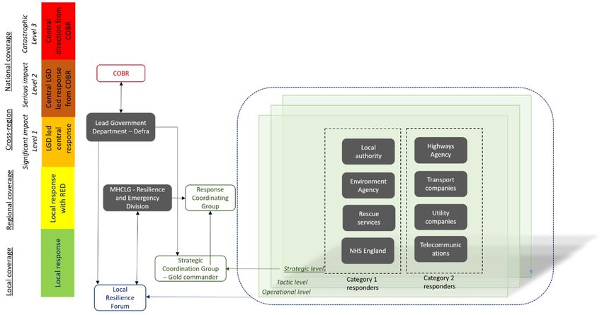
Water 2020, 12, 521                                                                                  2 of 22

      Effective and efficient flood emergency response has a key role in reducing the adverse impacts of
flooding. Coordinating the response—including warning and informing prior to and during events,
evacuation prior to the flooding, the rescue of people and the organization of volunteers [6]—has been
a priority for governments in recent decades. Although there are clearly lessons to be learned from
experiences in other countries, often the detailed arrangements need to be context specific.
      In England, revised flood emergency operational arrangements were put in place building on the
experience to date. These are outlined in the National Flood Emergency Framework [7]. The primary
aims of the emergency response include the protection of human life, the alleviation of suffering and
the restoration of disrupted services (e.g., water, electricity, transport). Within this framework and
based on documented command and control protocols, decisions are taken at the lowest appropriate
level with coordination at the highest necessary level.
      In India, the Central Government has established the National Disaster Management Division
within the Ministry of Home Affairs. This Division has introduced various initiatives and set up
several organizations to deal with disasters, including floods. In 2016, a National Disaster Management
Plan was published to provide the overall direction and national goals. Under the plan, the various
ministries and departments at state and district levels have to develop their own specific management
and response plans, and related operating procedures [8].
      Various emergency response activities rely on the information provided by monitoring, models
and multiple data sources. For example, in India hydrological and flood models are used by the
Central Water Commission for modelling and forecasting purposes [8] to provide water level and
river flow information to the authorities [9] with an online dissemination portal [10]. In England,
there has been a continuing interest in developing flood models for fluvial, pluvial and sea flooding [11],
with different data needs and outcomes [11,12], to help reduce the impacts on people, property and
critical infrastructure [13]. From the response side, emergency responders request and collate a varied
range of information, from aerial imagery to individual eyewitness reports, to support decision-making.
Different information is required pre-, during- and post-events. For instance, during a flood event
real-time or near real-time local information on how many people, buildings, and other infrastructure
are at risk is required [14]; post-event aerial imagery can provide vital and detailed information about
the extent of flooding and damage to properties [15].
      In recent years, emergency responders have used Unmanned Aircraft Systems (UAS) to acquire
core information pre-, during- and post-events [16–18]. UAS are small and light (less than 20 kg)
remotely piloted aircraft generally equipped with a range of sensors for the collection of information.
There are two main types of UAS platforms: fixed wing and vertical take-off and landing (VTOL).
The former relies on wings that generate lift to fly, whereas VTLO rely on rotors. UAS can be equipped
with different sensors [19] from cameras to warning systems. RGB cameras are able to provide high
resolution imagery of up to 2 cm. Emergency responders in various countries have identified the
added benefits of UAS in humanitarian responses in terms of the rapid assessment of damage, such as
collapsed buildings or blocked roads and search and rescue operations [20,21]. In England for example,
during winter 2015/2016, UAS were used by the Environment Agency (EA) to assess smaller scale
flooding incidents in high detail; in particular, UAS were used to provide an up close and detailed live
stream of an inaccessible river breach. This enabled an effective and efficient assessment of the area [22].
However, the rapid uptake and continuous development of the technology have resulted in the ad-hoc
and opportunistic use of UAS over a strategic appraisal of how best to use them and for what purpose
pre-, during- and post-events. Various types of UAS missions have been identified as being used
in flood emergency responses (including strategic situation awareness, inspections, ground search,
water search, debris/flood/damage estimation and tactical situation awareness) with an indication of
the data products (e.g., images, videos, and orthomosaics) generated in the flights [18]). However,
there is not yet a purpose-driven approach defining which UAS products would be of benefit at each
stage of the preparation for and response to a flood event. The need of such logic-based decision
support approach has been identified by multiple research and governmental organizations within the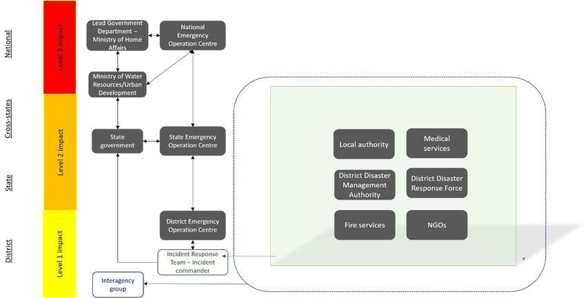
Water 2020, 12, 521                                                                               3 of 22

context of catastrophe response in India and England through two knowledge exchange workshops
organized in Delhi (30 September 2018) and Bangalore (18 September 2019) within the engagement
activities organized by the EPSRC research project ’Emergency flood planning and management
using unmanned aerial systems’ (www.efloodplan.net). To the authors’ knowledge, a purpose-driven
approach detailing how and when UAS with specific embedded sensors should be used to collect data
to assist in flood event responses is not yet documented. It is envisaged that such an approach will be
context-specific and influenced by the nature of the flood events that occur within a particular area,
region or country, the data available from other sources, as well as the airspace regulatory framework
for UAS use.
      Based on these premises, the aim of this study is to develop purpose led guidelines for the
efficient and effective deployment of UAS for flood risk management activities including emergency
response pre-, during- and post-event phases. We demonstrate how a deployment analysis matrix can
be designed and used to assist flood emergency response requirements in the context of catchment
response and the nature of flood events for England and explore its potential to be translated into
an Indian context. This will be achieved through the following four overarching objectives: (1) to map
out the current role of existing organizations involved in emergency response in England and India;
(2) to identify existing UAS applications within the components of a flood risk management system;
(3) to determine context-specific requirements for UAS products to assist in flood risk management
activities; and, (4) to develop an adaptive and transferable matrix analysis framework that can then
be used as the basis for guidelines for the effective deployment of UAS for flood risk management
activities leading to more resilient urban environments and including emergency response before,
during and after a flood event.

2. Materials and Methods

2.1. Flood Emergency Response in England and India and the Potential Use of UAS
     The institutional arrangements for flood emergency response and the current and potential
applications of UAS technology were determined through a literature review and face-to-face interviews
with key personnel with detailed understanding of the flood response arrangements in England and in
India. England and India were selected for this study based on recent flood events occurring in these
areas (Cockermouth, England, 2015 and Kerala, India, 2018). A total of 14 interviews were held in
India (7) and England (7), including participants with experience in flood emergency response from
the national and regional authorities, private sector and Non-governmental organizations (NGOs).
A semi-structured questionnaire based on a set of twenty open questions was used (Supplementary
Materials). This format enabled the interviews to be focused on the research objectives, but with
the flexibility to evaluate responses and explore issues that emerged during interviews. The raw
data products (i.e., those are provided without extra processing or internet connection) and derived
products (i.e., produced by post-processing of the raw data products) produced by UAS applications,
as well as the key factors affecting UAS deployment and flight plan configuration were also identified
in the literature review. Additional information on the main applications and potential use of UAS
was also obtained from a knowledge exchange workshop organized in India within the engagement
process of the EPSRC research project “Emergency flood planning and management using unmanned
aerial systems” (Delhi, 30 May 2018). The UAS applications were grouped into a set of five flood
management components, which included flood warning, flood monitoring and flood risk assessment,
evacuation route identification, damage assessment and rescue.

2.2. Development of an UAS Deployment Analysis Matrix
     This study uses a 3 × 3 matrix to identify potential uses of UAS in flood risk management
activities and as the basis of guidelines on the deployment of UAS for flood risk management activities.
A number of factors were considered for the x and y axes of the matrix when considering UAS
Water 2020, 12, 521 4 of 22
Water 2020, 12, 521 4 of 21
deployment
UAS deployment and flightandplan configurations.
flight The three
plan configurations. main
The threefactors
mainidentified were related
factors identified wereto catchment
related to
size,
catchment size, flood source type, and phase of a flood event (Table 1). Catchment size influences the of
flood source type, and phase of a flood event (Table 1). Catchment size influences the amount
data gathered
amount [23]gathered
of data and the type of UAS
[23] and that is
the type ofrequired
UAS thattoisprovide
requiredthe to spatial
providecoverage [24].
the spatial coverage
Catchment
[24]. flood response was chosen as one of the key factors because this gives an indication
of the time
Catchment flood response was chosen as one of the key factors because this gives an indication in
available to deploy an UAS and the use of particular applications and technologies
a given
of thesituation.
time availableThe catchment
to deploy an flood
UAS response
and the was determined
use of particular based on theand
applications timetechnologies
between theinstarta
of given
a rainfall event The
situation. andcatchment
the potential flood forresponse
the flooding of properties.
was determined Based
based on time
on the climatic and catchment
between the start
of a rainfall
conditions event and the
in England, the flood
potential for thewas
response flooding of properties.
considered Based when
to be ‘slow‘ on climatic and occurs
flooding catchmentmore
conditions
than 8 h afterinthe England,
rain event,the flood response
‘medium’ when was considered
flooding occurs to be ‘slow‘ 3
between when
and flooding occurs
8 h and ‘fast’ morethe
when
thanof8 flooding
onset h after the rain place
takes event,in ‘medium’
less thanwhen flooding
3 h [25,26]. Weoccurs between 3 and
also considered 8 h deployment
in the and ‘fast’ when the
analysis
onset of flooding takes place in less than 3 h [25,26]. We also considered
matrix the phase in which UAS will be deployed in the overall approach to flood risk management in the deployment analysis
matrix the
activities [27]:phase in which‘during-event’
‘pre-event’, UAS will be deployed in the overall
and ‘post-event’ approach
(Figure to flood risk
1). Pre-event management
refers to activities
activities
such as flood [27]: ‘pre-event’,
modelling ‘during-event’
activities, and ‘post-event’
the construction of flood(Figure 1). Pre-event
risk reduction assetsrefers
andto theactivities
planning
such as flood modelling activities, the construction of flood risk reduction assets
that will be needed to respond effectively to a defined flood magnitude (i.e., based on a return period). and the planning
that will be needed to respond effectively to a defined flood magnitude (i.e., based on a return
During-event starts as soon as the first flood warning is issued, whilst post-event refers to the recovery
period). During-event starts as soon as the first flood warning is issued, whilst post-event refers to
and clean-up phase when the water has receded and for example is no longer within people’s houses
the recovery and clean-up phase when the water has receded and for example is no longer within
or blocking transport routes.
people’s houses or blocking transport routes.
Table 1. Key factors identified as relevant for the development of the Unmanned Aircraft Systems
Table 1. Key factors identified as relevant for the development of the Unmanned Aircraft Systems
(UAS) deployment analysis matrix.
(UAS) deployment analysis matrix.
Factor
Factor Description
Description
Catchment size
Catchment size Size of the catchment where
Size of the catchment where the event
thehas taken
event hasplace
taken[23,24]
place [23,24]
Catchment
Catchment Catchment flood Catchment response to flooding after the rain event
Catchment flood responseCatchment response to flooding after the rain event occurs [28,29]
response occurs [28,29]
Flood source type Source of flooding classified
Source of flooding asclassified
groundwater, pluvial and fluvial
as groundwater, pluvial[30]
and
Flood source type
Flood The spatial coverage of the flood event fluvial
and[30]
the associated emergency
Flood
Flood extent The spatial
response coverage (e.g.,coverage of the
single scene, flood event
regional and and
coverage the associated
national
Flood extent emergency response coverage
coverage) [31] (e.g., single scene, regional
Emergency coverage and national coverage) [31]
Response Emergency response phases
Response Pre-event, during-event
Pre-event, and post-event
during-event [27,32] [27,32]
and post-event
response phases
Figure 1. Format of the UAS deployment analysis matrix.
Figure 1. Format of the UAS deployment analysis matrix.Water 2020, 12, 521 5 of 22
Each of the nine cells within the matrix were populated with the UAS applications identified from
the literature review and via a second set of ten one-to-one interviews in England. The interviews
targeted specialists in the use of UAS for monitoring, surveying and incident response within the EA,
Cranfield University, University of Exeter and an independent expert in flood risk management who
had extensive experience of emergency responses at a senior level. During each interview, responders
were presented with a set of cards defining the UAS applications, the processing time required to obtain
the UAS products and the accuracy or resolution of such products. Processing time, accuracy and
resolution were defined based on values reported in the literature. Responders were able to allocate the
UAS applications with a given processing time and accuracy within the context of a recent flood event
in which they were involved. The data gathered in the matrix was analyzed to identify the consistency
between participants in allocating an application to a particular matrix cell. Consistency between
participants was assessed through direct comparison of the number of responses per application
and cell.
A workshop organized in India (Bangalore, 18 September 2019) helped provide insights about the
transferability of the designed deployment analysis to an Indian context. Discussions with experts on
flood risk management activities including emergency response in India were held to determine the
potential transferability of the matrix to other countries.
2.3. Technological Needs for the Use of UAS in Flood Emergency Response
To assess how the technology should be further developed to meet flood emergency response
needs, an extended online survey was also carried out (See Supplementary Materials for details of
the survey). The UAS applications—flood extent, flood depth and flow velocity—were selected as
they are considered to be key for making decisions during a flood event [33,34]. For the three UAS
applications, participants were asked about the current and desired time to process these specific
geomatics products and the associated accuracy requirements. Accuracy refers to the expected error
range in flood extent (m), flood depth (cm) and flow velocity (m s−1 ) in the generated geomatics
product. The survey was built in Qualtrics software and distributed to relevant experts and at two
flood risk management related events: Oasis Conference (London, 18 June 2019) and Flood and Coast
(Telford, UK, 20 June 2019). A total of 25 participants completed the survey. Data collected were
compared using descriptive statistics to assess the current and desired accuracies and time to process
each application. The information gathered enabled an assessment to be made as to whether there are
any knowledge and technology gaps that need to be addressed to achieve a desired time and accuracy
for a given application.
3. Results
3.1. Organizations Involved in Flood Emergency Response: England and India
Results from the literature review and one-to-one interviews highlighted that in England there
are over 17 organizations involved in flood emergency response. This is similar to the number in India,
where 16 key organizations were identified (see Supplementary Materials).
In England, the response to localized flooding is led by the local emergency responders without
any significant involvement from central government [35]. For some flood events, local responders are
supported by central government via Department for Environment, Food and Rural Affairs (Defra) as
the designated Lead Government Department for responding to floods. Defra normally co-ordinates
the cross-government response to lower level national flooding events (level 1) and manage it within
the department. As the extent and impact of the flooding increases, it is likely that there will be
increasing involvement by others in central government with the activation of the Cabinet Office
Briefing Room (COBR), which brings together ministers, seniors government officials, representatives
from national response agencies and organizations impacted by the flood event. Level 2 events (serious
impact) are still coordinated by Defra but through COBR. More serious events (level 3—catastrophic)Water 2020, 12, 521 6 of 22
Water 2020, 12, 521 6 of 21
are fully escalated
Secretariat to central
within COBR co-ordination
[7] (Figure by theand
2). The Army Civil Contingencies
other Secretariat
military forces within COBR
may be requested [7]
to help
(Figure 2). The Army and
in a flood response [36]. other military forces may be requested to help in a flood response [36].
Schematic diagram
Figure 2. Schematic diagram of of flood
flood emergency
emergency response in England showing the main agencies and
groups involved, the levels of emergency responses at the local level (operational, tactical,tactical, strategic),
strategic),
the categories of responding organizations (Category
(Category 1 and Category 2) and the likely government
arrangements (from local response to central direction from COBR) which depends upon flood extent
(local, regional,cross-region
(local, regional, cross-regionandandnational).
national).Category
Category 1 comprises
1 comprises the the organizations
organizations thatthat are
are at theatcore
the
corethe
of of response
the response to most
to most emergencies,
emergencies, whereas
whereas Category2 2responders
Category respondersareare co-operating
co-operating bodies
bodies
involved in
involved in incidents
incidents that
that affect
affect their
their sector. The color
sector. The color schemes
schemes inin the
the government
government arrangements
arrangements
reflect the increasing levels of emergency response (from green to red). COBR:
reflect the increasing levels of emergency response (from green to red). COBR: Cabinet Cabinet Office
Office Briefing
Briefing
Rooms, Defra: Department for Environment, Food and Rural Affairs, MHCLG: Ministry
Rooms, Defra: Department for Environment, Food and Rural Affairs, MHCLG: Ministry of Housing, of Housing,
Communities and
Communities and Local
Local Government,
Government, RED: RED: Resilience
Resilience and
and Emergency
Emergency Division,
Division, and
and LGD:
LGD: LeadLead
Government Department.
Government Department.
At present,
At present, therethereare area number
a number of organizations
of organizations thatthat
maymay use UAS
use UAS during during
a flooda event.
flood These
event.
These include the EA, the Fire and Rescue Service, the Police and
include the EA, the Fire and Rescue Service, the Police and insurance companies as well as private insurance companies as well
as private individuals. As an example, in England, the local or national
individuals. As an example, in England, the local or national incident responders may request the incident responders may
request the deployment
deployment of UAS to the of UAS to theGeomatics
specialist specialist Team Geomatics
of theTeam
EA toof provide
the EA to provide information
information related to
related to flood damage and impacts [37]. The Geomatics
flood damage and impacts [37]. The Geomatics Team will evaluate if UAS are the Team will evaluate if UAS
mostare the most
appropriate
appropriate
means means ofthe
of obtaining obtaining the information.
information. One of theOne of the interviewees
interviewees informed informed
us that us that arrangements
arrangements are in
are in place that allow the EA’s Geomatics Team to deploy UAS
place that allow the EA’s Geomatics Team to deploy UAS in any part of England within in any part of England withinsix
sixhours.
hours.
The UAS images can be sent via a live feed to an EA incident room. The
The UAS images can be sent via a live feed to an EA incident room. The decision as to who will decision as to who will fly UAS
fly
in a particular
UAS situation
in a particular is agreed
situation locally locally
is agreed event byevent event.byTo date, To
event. there is not
date, therean established approach
is not an established
to decide which
approach to decideorganization will fly UAS
which organization willforflywhat
UASpurpose
for whatduring
purpose andduring
after an andevent.
afterThis can result
an event. This
in a duplication of effort or in important information not being gathered during
can result in a duplication of effort or in important information not being gathered during a particular a particular event.
event.India also has a tiered approach to flood emergency response (Figure 3). The national government
develops
Indiapolicies
also has andaprovides advice andtoassistance
tiered approach when there
flood emergency are major(Figure
response events,3).whilst
Thethe States
national
are the responsible
government develops forpolicies
carryingand outprovides
risk assessments
advice and andassistance
planning whenand implementing
there are major mitigation
events,
whilst the States are the responsible for carrying out risk assessments and planningLevel
measures [8]. At the district level, flood events are categorized into three levels of impact [38]: and
1—there are sufficient resources and capacity to respond at the district
implementing mitigation measures [8]. At the district level, flood events are categorized into three level; Level 2—the impact is
beyond
levels ofexisting capacities
impact [38]: Level and1—theresupportare from Stateresources
sufficient agencies and
is needed;
capacity and to Level
respond 3—the impact
at the is
district
beyond the existing capacities of district and state resources and support
level; Level 2—the impact is beyond existing capacities and support from State agencies is needed; from national agencies is
needed
and Level (Figure
3—the 3).impact
If an emergency
is beyond the escalates
existing beyond their of
capacities capabilities,
district and the local
state administration
resources and supportmust
from national agencies is needed (Figure 3). If an emergency escalates beyond their capabilities, the
local administration must seek assistance from the district administration or the State Government.Water 2020, 12, 521 7 of 22
Water 2020, 12, 521 7 of 21
seek assistance from the district administration or the State Government. If the State Government
considers
If the StateitGovernment
necessary, it considers
can seek central assistance
it necessary, [8].seek
it can Thecentral
Ministry of Water[8].
assistance Resources (river of
The Ministry flooding)
Water
and Ministry
Resources of flooding)
(river Urban Development
and Ministry(pluvial
of Urban flooding)
Development function underflooding)
(pluvial the overall guidance
function underof the
the
Ministry of Home Affairs [8,39] when responding to flood events.
overall guidance of the Ministry of Home Affairs [8,39] when responding to flood events.
In India
In India the
the police,
police, navy
navy andand army
army have
have permission
permissionto tofly
fly UAS
UASforforsecurity
securityandandrescue
rescuereason.
reason.
However, as
However, asininEngland,
England, there is not
there an established
is not an establishedsystem to deploy
system UAS inUAS
to deploy floodinemergency response
flood emergency
activities. For example, in the 2013 Uttarakhand floods, the National Disaster
response activities. For example, in the 2013 Uttarakhand floods, the National Disaster Response Response Force (NDRF)
deployed
Force UAS deployed
(NDRF) with technical
UASsupport from research
with technical support institutions [40,41].
from research The Indian[40,41].
institutions securityThe
forces and
Indian
the Indo-Tibetan Border Police also deployed UAS to assist in the relief efforts of
security forces and the Indo-Tibetan Border Police also deployed UAS to assist in the relief efforts of the National Disaster
Response
the NationalForce by helping
Disaster find survivors
Response in remote
Force by helping locations
find [42] in
survivors and in areas
remote cut off by
locations landslides
[42] [43].
and in areas
During
cut the
off by interviews
landslides performed
[43]. During the in Delhi, Indian
interviews participants
performed highlighted
in Delhi, the opportunities
Indian participants to use
highlighted
UAS at the district level by the District Collector, who is responsible for district-level
the opportunities to use UAS at the district level by the District Collector, who is responsible for responses to
a flooding event.
district-level responses to a flooding event.
Figure
Figure 3.
3. Schematic
Schematic diagram
diagram of of flood
flood emergency
emergency response
response in
in India
India showing
showing the
the main
main agencies
agencies and
and
groups
groups involved and the levels of emergency responses (level 1, level 2 and level 3) which depends
involved and the levels of emergency responses (level 1, level 2 and level 3) which depends
upon
upon the
the flood
flood extent
extent (district,
(district, state,
state, cross-states,
cross-states, national).
national).
3.2. The
3.2. ThePotential
PotentialUse
Use of
of UAS
UAS in
in Flood
Flood Emergency
Emergency Response
Response
From the
From the existing
existing scientific
scientific literature,
literature, sixteen
sixteen UAS
UAS applications
applications that
that could
could be
be used
used in in flood
flood risk
risk
management activities were identified. The UAS applications can be assessed in
management activities were identified. The UAS applications can be assessed in terms of their use terms of their use
before an
before an event
event in
in flood risk assessments,
assessments, determining
determining terrain
terrain elevations,
elevations, flood
flood extent
extent modelling,
modelling,
identifying evacuation routes and flood warning. During an event to inform
identifying evacuation routes and flood warning. During an event to inform responders about actualresponders about
actualextents,
flood flood extents, flood sources
flood sources and routes,
and routes, whetherwhether evacuation
evacuation routes remain
routes remain clear, identifying
clear, identifying people
people
in in rescue
need of need ofandrescue and provision
provision of emergencyof emergency relief
relief supply. supply.
Post eventsPost events
as part as partand
of damage of damage
impact
and impact assessments.
assessments. UAS raw
UAS raw products products
included high included
definitionhigh
(HD)definition (HD) video,
video, infrared infrared
imaging, imaging,
Red-Green-
Red-Green-Blue
Blue (RGB) imagery,(RGB)
RGB imagery, RGBvideo
video, RGB video,streaming
RGB video andstreaming and thermal
thermal imaging. imaging.
A total A total
of fourteen of
post-
fourteen post-processing outcomes were identified: those derived from models
processing outcomes were identified: those derived from models (e.g., flood models, evacuation (e.g., flood models,
evacuation
models), models),
bespoke bespoke algorithms
algorithms (e.g., image (e.g., image
feature feature recognition),
recognition), UAS-specific
UAS-specific softwaresoftware (e.g.,
(e.g., terrain
terrain elevation
elevation measurements)
measurements) (Table 2).
(Table 2).Water 2020, 12, 521 8 of 22
Table 2. Detailed list of flood risk management components, with identified applications, UAS raw products and post-processed outcomes from the literature within
the context of flood emergency response. The processing time for outcome generation and the accuracy of the outcome is also indicated. DEM, DTM and DSM stand
for Digital Elevation Model, Digital Terrain Model and Digital Surface Model, respectively.
Flood Management Processed
Applications Examples UAS Raw Product Time Details 3
Component Outcome
UAS with an embedded audible alarm to provide an alert
Flood warning Evacuation warning about an upcoming flood and the need for evacuation N/A N/A Real-time Flight path reach
(Mozambique).
Visualization of Delineation of inundated areas by digitizing the boundaries RGB imagery RGB Flood extent, Real time 0.2 m high resolution
flood extent at the contrasting land surface/water boundary [28]. video Ponding locations (48h 1
Flood extent detection automatically [44,45]. flood extent RGB imagery 4
A spectral difference index is generated from the RGB Orthoimage, Real time 0.2 m high resolution
RGB imagery
photos to map flood water extent [46]. flood extent (Water 2020, 12, 521 9 of 22
Table 2. Cont.
Flood Management Processed
Applications Examples UAS Raw Product Time Details 3
Component Outcome
Flood source Sources of flooding can be identified based on damaged
RGB frames Orthoimage,
identification (fluvial, caused within/outside the fluvial flood extent [15,57] or >48 h 1 m resolution (DEM)
Thermal frames DEM, DTM, DSM
pluvial, groundwater) based on differences in water temperature [58].
Modelling of evacuation routes by using UAS as end Map of
Modelled evacuation devices of M2M architecture [59]. The input model needs RGB imagery evacuation routes, 20–60% trackingWater 2020, 12, 521 10 of 22
3.3. The UAS Deployment Analysis Matrix for England: Pre-, During- and Post-Event
Results (Figure 4) showed that pre-event for all catchment responses, the UAS applications were
primarily concerned with digital elevation models for use in flood models, the condition of flood risk
management assets, identification of safe shelter points and evacuation routes and providing warnings.
During the event applications providing information in real-time were prioritized. A combination
of rapid visualization with high resolution of flood extent and flood depth were chosen. This can be
provided with the current UAS technical capabilities. In fast response catchments, the participants’
preference was for flow velocity with medium accuracy (instead of high accuracy). Additional time
and costs are needed to achieve higher accuracies. Real-time applications relating to rescue activities
(i.e., identification of safe shelter points, detection of stranded people and delivery of ad-hoc supplies)
and damage assessment (i.e., visual detection of affected properties) were also identified as priorities.
Participants stated that applications requiring more than 4 h of processing time to generate products
are unlikely to be of use to responders in many flood events.
With the limitations of current UAS applications, the updating of evacuation routes was identified
as being important only in catchments with a flood response longer than 12 h or where the duration
of flooding in a faster responding catchment persists for more than 12 h. Applications that need
more than 48 h of processing time, such as modelling flood extent and the identification of resilience
and resistance measures, were still identified as being important as the data collected can be used
subsequently to improve flood models and the response for future flood events.
During an event time is the priority, whereas after the event accuracy was most relevant. The focus
in post event data collection was on the provision of more precise information for flood extent, flood
depth and flood source so that flood impact can be estimated more accurately. After an event, there is
also a continuing need for information that will assist with the rescue and recovery activities and the
estimation of property level flood impacts.
3.4. Preferences in England for UAS Applications in Flood Emergency Response
The online survey evaluated the existing and desired processing time and accuracy in UAS
applications for flood emergency response in England, as a way to determine whether technological
development is needed to better inform emergency response. Results from the online survey indicated
that 44% of participants currently have access to flood extent data within 12 h, with accuracies from
2 cm to 50 m. Only 3 of the 25 participants indicated they have access to flood extent data in less than
1 h with accuracies between 1 and 50 m. The preference of 52% of the participants was to have access to
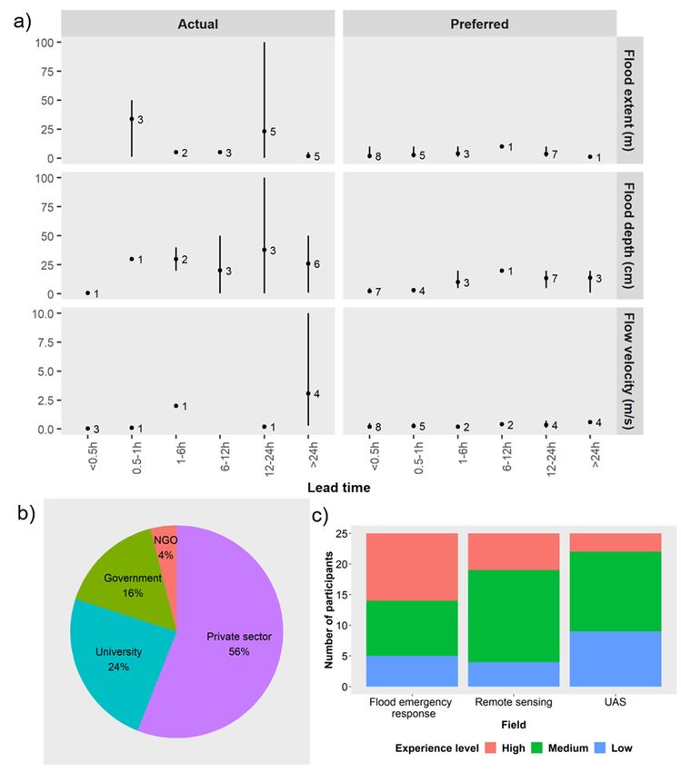
flood extent data within 0.5 h (i.e., near real time) with an accuracy ofWater 2020, 12, 521 11 of 22
Water 2020, 12, 521 11 of 21
- Evacuation warning [48h, 1m resolution] 4 - Flood extent [48h, building level resolution] 7 - Flow velocity [Water 2020, 12, 521 12 of 21
Water 2020, 12, 521 12 of 22
(a) Actual and
Figure5.5. (a)
Figure and preferred
preferredaccuracy
accuracyvalues
valuesand time
and needed
time to process
needed floodflood
to process extent, flood flood
extent, depth
and flow velocity. The marker indicates the average of flood extent, flood depth
depth and flow velocity. The marker indicates the average of flood extent, flood depth and flow and flow velocity,
whereas the
velocity, vertical
whereas lines
the showslines
vertical the minimum
shows the and maximumand
minimum values. The number
maximum values.of participants
The numberwith of
a preferencewith
participants for aagiven combination
preference are indicated
for a given against
combination areeach measure.
indicated (b) Type
against eachofmeasure.
organizations that
(b) Type
ofcompleted the survey.
organizations (c) Participants’
that completed experience
the survey. level in flood
(c) Participants’ emergencylevel
experience response, remote
in flood sensing
emergency
and UAS. Results obtained from 25 participants.
response, remote sensing and UAS. Results obtained from 25 participants.
Forflood
For floodextent
extent13
13participants
participantsconsidered
consideredtime
timemore
moreimportant
importantthan
thanaccuracy
accuracywhen
whengenerating
generating
a product that will assist flood emergency response, whereas 12 participants thought
a product that will assist flood emergency response, whereas 12 participants thought accuracy was accuracy was
moreimportant
more importantthan
thantime.
time.Some
Someparticipants
participantsstated
statedthat
thatthe
themost
mostimportant
importantfactor
factorfor
forthem
themwas
wasthe
the
trustworthiness of the data source. For flood depth (16) and flow velocity (17) participants
trustworthiness of the data source. For flood depth (16) and flow velocity (17) participants were morewere more
interestedin
interested inimproved
improvedaccuracy
accuracythan
thanin
inthe
thetime
timetaken
takentotoobtain
obtain the
the data.
data.Water 2020, 12, 521 13 of 22
4. Discussion
4.1. A Purpose-Driven Approach to UAS Deployment in the Context of Flood Emergency Response
The operational use of UAS in flood emergency response is still limited [69]. A more systematic
analysis of their application and capabilities in relation to their use in flood risk management including
as part of an effective response to an event is, therefore, required if a purpose-driven approach to their
deployment is to be realized.
During Storm Desmond in Cockermouth (Cumbria, England) in December 2015, more than 300 mm
of rain fell over a 24 h period with an estimatedWater 2020, 12, 521 14 of 22
• There is time to produce digital elevation and surface and terrain models which can then be
used within flood models to estimate, for a given return period rainfall event, the likely extent,
depth and velocity of flooding. The information produced can also be used to identify locations
for temporary barriers, shelter points and evacuation routes.
• Flood models can be used to identify the likely fluvial, pluvial and coastal sources (e.g., [15]) and
routes of flooding and can then enable potential evacuation routes to be identified (e.g., [82,83]).
• If flooding has been forecast for a particular area, UAS-based audio systems can be used to provide
audible warnings to those at risk.
During a flood event:
• High levels of accuracy are often not a priority. The timeliness of the information being available
to inform the response activities is paramount.
• Providing information in real-time is key as it enables effective prioritization of emergency
response actions including: to identify where to deploy maintenance crews to deal with blockages
and low spots in defences which are giving rise to unexpected sources of flooding; to identify
whether the flooding is developing in line with modelled predictions in terms of extent and depth;
to determine whether flooding is occurring in areas outside of those predicted by the models;
to assess whether evacuation routes remain clear of flooding; to identify people and properties
impacted by the flooding.
• During an event, typically time is limited to carry out new simulations [14]. During the event
responders potentially identify gaps in the existing flood emergency plan (i.e., location of shelter
points, evacuation routes, knowledge about resistance and resilience measures). However,
in an event that exceeds the planned preparedness plan, it may be necessary to rerun the
evacuation routes models.
• UAS can be used to determine the extent, depth and velocity of the flooding and the properties
impacted. This information can be extremely valuable after the event to calibrate and refine the
models and to determine whether additional flood risk reduction measures are required.
• Many organizations are involved in responding to flood events [81]. The use of UAS should
be discussed well in advance of any need to deploy them including what information will be
collected, how, by whom and for what purpose.
• UAS of the correct specification, including specified sensors and trained pilots will have to be
available for deployment within an agreed standard of service.
After an event:
• UAS can be used to help determine the impact on people, properties and infrastructure, the flood
extents and depths, and in identifying where best to deploy those still involved in rescue activities
and in the recovery operations.
• UAS can be used to collect information that enable the calibration and validation of those models
used pre-event for flood prediction purposes. Data collected at this stage will also look at features
highlighting flood impact (e.g., properties affected). The EA with its strategic overview role for
flood risk management in England would be well placed to develop guidelines for the use and
deployment of UAS in this context and then to oversee their implementation.
4.3. Selecting the Correct UAS Platform
Multiple UAS platforms are available for use. The selection of the most appropriate platform for
a particular application is a complex task. Factors that need to be considered include the capability of
the gimbal to integrate the payload, weather conditions, the extent of the area to be flown, and the
availability of pilots with the rights skills and regulatory permissions. UAS can be classified into
vertical take-off-and-landing (VTOL), fixed wing and hybrids [84]. In Rivas et al. [85], the authorsWater 2020, 12, 521 15 of 22
highlight that VTOL UAS are able to hover over a point and provide high resolution still imagery
whereas fixed wing platforms enable wide area surveying [85,86].
The flooding of large areas, which will most likely occur in catchment areas with a slow response
to floods, will require the use of fixed wing rather than VTOL platforms, as the former have longer
endurance, although they are more difficult to fly and require specific training [87]. However, some fixed
wing platforms do not have the capability of slowing down to speeds that enable them to collect high
resolution imagery. Rivas Casado et al. [85] report 8 h to map the river channel of a 1.4 km reach,
when using a rotor platform (Falcon 8 octocopter, ASCTEC, Krailling, Germany) whereas the same
author reported a coverage of 142 ha within four hours in two flights undertaken with a Sirius Pro fixed
wing [15]. Fixed wing platforms such as the Sirius Pro enable flights of up to 50 min at a cruising speed
of 18 m s−1 [88]. In certain locations, VTOL UAS will also be required to overcome the limitations of
terrain in terms of take-off and landing [19]. VTLOs can hover on site with high location accuracy and,
therefore, take more detailed photographs at locations of interest. Hybrid models are able to combine
the advantages of both fixed wing and VTOL platforms. The WingtraOne PPK VTO is a hybrid rotor
and fixed wing platform able to provide Ground Sampling Distances of 0.7 cm/pixel and map 400 ha in
a single flight [89]. The battery endurance is 55 min. The platform is able to fly under wind conditions
of up to 45 km h−1 in cruise and up to 30 km h−1 for landing.
Battery endurance can also compromise performance. Overall, fixed wing platforms provide better
battery endurance than VTOL platforms. Figure 6 and Table 3 show an alternative classification for UAS
based on battery endurance and work range. Low-cost close range UAS include platforms with a range
of generally up to 5 km and an endurance time of less than 45 min. Examples of such platforms include
standard small VTOL platform such as the DJI Phantom 4 Pro (DJI Technology Co, Shenzhen, China)
which can fly continuously for over 30 min [90] at a maximum speed of 20 m s−1 . Such platforms will
be suitable to cover small catchments or specific areas of medium to large catchments. More expensive
close-range platforms offer a working range of up to 50 km with battery endurance of up to 6 h.
The mdMapper4-3000DµoG VHR VTLO (microdrones) is an example of such a platform able to capture
RGB imagery at a ground sampling distance (GSD) of up to 0.6 cm/pixel [91]. The platform has an
endurance of approximately 40 min when flying at an altitude of 120 m. The UAS can cover between
64 ha (80 mm lens, GSD = 0.6 cm/pixel) and 150 ha (35 mm lens, GSD = 1.3 cm/pixel) at a constant
speed of 5 m s−1 within a single flight. A fixed wing example of a close-range platform is the Sirius Pro
(Topcon Positioning System Inc., Livermore, CA, USA) which has a 50 min flight endurance and is able
to operate under windy conditions (50 km h−1 ) with gusts of up to 65 km h−1 [92]. Another example is
the eBeeX which is able to gather RGB imagery at 1 cm/pixel and cover 220 ha in a single flight when
flying at an altitude of 120 m. Short-range, medium-range and high-endurance platforms all require
runways for their deployment and, although they provide a larger working range and endurance,
are difficult to deploy in urban settings, especially during flood events.
In large flooded areas, there is likely to be a need to coordinate the deployment of multiple UAS
within an affected area. The surveying of large areas will result in larger data sets and this will have
a consequential impact on the time taken to generate products. More stable and perhaps heavier
platforms, such as the microdrone md4-1000 [93], are needed for more extreme wind and rainfall
conditions. Additional advances will enable the miniaturization of sensors, enhance the level of
autonomy, increase battery life and the capability of flying in more extreme weather conditions.50 min flight endurance and is able to operate under windy conditions (50 km h−1) with gusts of up
to 65 km h−1 [92]. Another example is the eBeeX which is able to gather RGB imagery at 1 cm/pixel
and cover 220 ha in a single flight when flying at an altitude of 120 m. Short-range, medium-range
and high-endurance platforms all require runways for their deployment and, although they provide
a larger working range and endurance, are difficult to deploy in urban settings, especially during
Water 2020, 12, 521 16 of 22
flood events.
Figure 6. Simplified classification of UAS platforms based on their work range (km) and battery
Figure 6.time
endurance Simplified classification
(h). The different ofinclude
classes UAS platforms based on their
low-cost close-range (CR), work range(CR),
close-range (km)short-range
and battery
(SR), medium-range (MR) and high-endurance (Endurance) platforms. A full description(CR),
endurance time (h). The different classes include low-cost close-range (CR), close-range short-
of these
range (SR), medium-range
classes is provided in Table 3. (MR) and high-endurance (Endurance) platforms. A full description of
these classes is provided in Table 3.
Table 3. Description of the simplified classification of UAS.
UAS Type Range (km) Endurance Time (h) Remarks
This type includes Micro and Nano air
vehicles, low altitude flying with
Low cost close range 5 1/3—3/4
a maximum altitude of ca. 1000 m,
no need for runways.
Close range 50 1—6 Need runways, altitude up to ca. 1500 m.
Need runways, altitude of a few
Short range 150 8—12
thousand meters.
Mid-range 650 - Need runways, altitude up to 9000 m.
Need runways, altitude of 20,000 m
Endurance 300 36
or more.
4.4. The Deployment Decision Approach to an Indian Context
Our deployment analysis matrix approach for the use of UAS in flood risk management activities
in England has the potential to be transferred to other countries (e.g., India) with different climatic,
topographic and socioeconomic contexts. In India, environmental conditions can be extreme in terms
of the intensity and extent of the rainfall. Transferability of the matrix will need to take into account
the catchment response. In India, some catchments are of a larger scale than those in England and
can be flooded for weeks with a need for recurrent monitoring of large areas. One of the challenges
faced is the need to evacuate large numbers of people over extended areas in a short period [82].
The size of the areas affected will require the deployment of certain types of UAS (Section 4.3) for
particular applications. In India, rural areas can also present access, travel time and maintenance
challenges [82,94] with landslides limiting access to remote areas [95,96].
5. Conclusions
UAS are currently used in a largely ad hoc manner in flood risk management activities with
practice differing significantly even within countries. Even so, their use has proved to be beneficial.
However, if they were to be used in a purpose-driven and strategically coordinated way, they can
provide more coherent and targeted information that will have added value for flood risk management
activities, including during the response to events. The data and information produced by UAS can
be used to improve flood risk management activities, structures, tools and approaches helping to
reduce flooding and its associated impacts on people, properties, infrastructure and the economy.Water 2020, 12, 521 17 of 22
We have identified a range of products that can be delivered by UAS and have developed an analysis
matrix approach to help target their deployment. The UAS deployment matrix forms the basis for
developing guidelines to assist those involved in flood risk management activities, including emergency
responders, in developing a more strategic and targeted approach to the use of UAS before, during
and after flood events. The approaches developed will need to be context specific including who
will use what type of UAS and for what purpose before, during and after an event. The deployment
matrix we have developed for England has the potential to be translated into an Indian context, and in
other countries.
Further research should focus on exploring future technological developments of UAS platforms
and sensors, their potential applications within a flood emergency response context and how these
will feed into the existing deployment guidelines. Technological developments would be particularly
helpful in the miniaturization of sensors, their integration on more stable UAS platforms and increased
flight (i.e., battery) endurance. The fast pace of technological advances within the field of UAS
requires a flexible and adaptive approach, which facilitates operational uptake as soon as advances
are commercially available. The various organizations involved in the use of UAS in flood risk
management will have to keep the deployment guidelines under review if they are to make the best
use of the available and developing technologies to achieve flood management and resilience targets.
Supplementary Materials: The following are available online at http://www.mdpi.com/2073-4441/12/2/521/s1,
Table S1: Organisations involved in the flood emergency response in England and India and their associated role.
Author Contributions: Conceptualization, G.S., P.L., M.R.C., M.M., D.B. and P.P.M.; methodology, G.S., M.R.C.,
P.L. and M.M.; validation, G.S.; formal analysis, G.S. and M.M.; investigation, G.S., M.R.C., P.L. and M.M.;
resources, M.R.C., P.L., D.B. and P.P.M.; data curation, G.S. and M.M.; writing—original draft preparation, G.S.,
M.R.C. and P.L.; writing—review and editing, G.S., P.L., M.R.C., M.M., D.B. and P.P.M.; supervision, M.R.C. and
P.L.; project administration, M.R.C.; funding acquisition, D.B., P.L., P.P.M. and M.R.C. All authors have read and
agree to the published version of the manuscript.
Funding: This research was funded by EPSRC, EP/P02839X/1 “Emergency flood planning and management using
unmanned aerial systems” and EPSRC EP/N010329/1 “BRIM: Building Resilience Into risk Management”. Due to
the ethically sensitivity nature of the research (interviews), supporting data cannot be made available.
Acknowledgments: The authors acknowledge the support from the following institutions and experts from
England and India: Environment Agency, Central Water Commission, National Institute Disaster Management,
International Federation of Red Cross, Goonj, Seeds, R.K. Dave, and Ruchi Saxena.
Conflicts of Interest: The authors declare no conflict of interest.
References
1. U.S. House of Representatives. A Failure of Initiative. Final Report of the Selected Bipartisan Committee to
Investigate the Preparation for and Response to Hurricane Katrina; U.S. House of Representatives: Washington,
DC, USA, 2006.
2. Hallegatte, S. An adaptive regional input-output model and its application to the assessment of the economic
cost of Katrina. Risk Anal. 2008, 28, 779–799. [CrossRef] [PubMed]
3. AON Global Catastrophe Recap: October 2018; AON Empower Results: London, UK, 2018. Available
online: http://thoughtleadership.aonbenfield.com/Documents/20181107-ab-analytics-if-oct-global-recap.pdf
(accessed on 11 February 2020).
4. Venkataraman, A.; Suhasinini, R.; Abi-Habib, M. After Worst Kerala Floods in a Century, India Rejects
Foreign Aid. Available online: https://www.nytimes.com/2018/08/23/world/asia/india-kerala-floods-aid-
united-arab-emirates.html (accessed on 24 November 2019).
5. Environment Agency. Managing Flood and Coastal Erosion Risks in England: 1 April 2011 to 31 March 2017;
Environment Agency: Bristol, UK, 2018. Available online: https://www.gov.uk/government/publications/
flood-and-coastal-risk-management-national-report (accessed on 11 February 2020).
6. Paciarotti, C.; Cesaroni, A.; Bevilacqua, M. The management of spontaneous volunteers: A successful model
from a flood emergency in Italy. Int. J. Dis. Risk Reduct. 2018, 31, 260–274. [CrossRef]
7. Defra the National Flood Emergency Framework for England. December 2014; Department for Environment,
Food and Rural Affairs: London, UK, 2014.Water 2020, 12, 521 18 of 22
8. NDMA National Disaster Management Plan (NDMP); National Disaster Management Authority Government:
New Delhi, India, 2016. Available online: https://ndma.gov.in/images/policyplan/dmplan/National%
20Disaster%20Management%20Plan%20May%202016.pdf (accessed on 11 February 2020).
9. WMO; US NOAA; US NWS; HRC. Proceedings of the USAID/OFDA First Steering Committee Meeting
(SCM 1) of The South Asia Flash Flood Guidance (SAsiaFFG) Project, New Delhi, India, 26–28 April 2016;
p. 29.
10. CWC Flood Forecast. Central Water Commission. Available online: http://14.143.182.4/ffs/ (accessed on 28
October 2019).
11. Oleo, M. Developing Data Standards for Flood Models; Cranfield University: Cranfield, UK, 2018.
12. Neelz, S.; Pender, G. Benchmarking the Latest Generation of 2D Hydraulic Modelling Packages; Environment
Agency: Bristol, UK, 2013; ISBN 0234-1026.
13. Evans, E.P.; Simm, J.D.; Thorne, C.R.; Arnell, N.W.; Ashley, R.M.; Hess, T.M.; Lane, S.N.; Morris, J.;
Nicholls, R.J.; Penning-Rowsell, E.C.; et al. An Update of the Foresight Future Flooding 2004 Qualitative Risk
Analysis; An independent review by Sir Michael Pitt; Cabinet Office: London, UK, 2008.
14. Ward, P.J.; Jongman, B.; Salamon, P.; Simpson, A.; Bates, P.; De Groeve, T.; Muis, S.; De Perez, E.C.; Rudari, R.;
Trigg, M.A.; et al. Usefulness and limitations of global flood risk models. Nat. Clim. Chang. 2015, 5, 712–715.
[CrossRef]
15. Rivas Casado, M.; Irvine, T.; Johnson, S.; Palma, M.; Leinster, P. The use of unmanned aerial vehicles to
estimate direct tangible losses to residential properties from flood events: A case study of Cockermouth
Following the Desmond Storm. Remote Sens. 2018, 10, 1548. [CrossRef]
16. UN-OCHA Unmanned Aerial Vehicles in Humanitarian Response; United Nations Office for the Coordination of
Humanitarian Affairs: New York, NY, USA, 2014.
17. Kim, K.; Davidson, J. Unmanned Aircraft Systems Used for Disaster Management. Transp. Res. Rec. J. Transp.
Res. Board 2015, 2532, 83–90. [CrossRef]
18. Fernandes, O.; Murphy, R.; Adams, J.; Merrick, D. Quantitative Data Analysis: CRASAR Small Unmanned
Aerial Systems at Hurricane Harvey. In Proceedings of the 2018 IEEE International Symposium on Safety,
Security, and Rescue Robotics (SSRR), Philadelphia, PA, USA, 6–8 August 2018; pp. 1–6.
19. Watts, A.C.; Ambrosia, V.G.; Hinkley, E.A. Unmanned aircraft systems in remote sensing and scientific
research: Classification and considerations of use. Remote Sens. 2012, 4, 1671–1692. [CrossRef]
20. Reliefweb. Drones Used for Good-Relief Organisation Uses Drones to Map Typhoon Haiyan Recovery
Efforts. Available online: https://reliefweb.int/report/philippines/drones-used-good-relief-organisation-uses-
drones-map-typhoon-haiyan-recovery (accessed on 25 April 2019).
21. Santos, L.A. In the Philippines, Drones Provide Humanitarian Relief. Available online: https://www.devex.
com/news/in-the-philippines-drones-provide-humanitarian-relief-82512 (accessed on 31 May 2019).
22. Mathew, A. Up, up and very Far away: Remote Sensing in Flood Response. Available online: https://
defradigital.blog.gov.uk/2017/03/30/up-up-and-very-far-away-remote-sensing-in-flood-response/ (accessed
on 18 April 2019).
23. Schumann, G.J.-P.; Muhlhausen, J.; Andreadis, K.M. Rapid Mapping of Small-Scale River-Floodplain
Environments Using UAV SfM Supports Classical Theory. Remote Sens. 2019, 11, 982. [CrossRef]
24. DeBell, L.; Anderson, K.; Brazier, R.E.; King, N.; Jones, L. Water resource management at catchment scales
using lightweight UAVs: Current capabilities and future perspectives. J. Unmanned Veh. Syst. 2016, 4, 7–30.
[CrossRef]
25. Dale, M.; Dempsey, P.; Dent, J. Defra/Environment Agency Flood and Coastal Defence R & D Programme; Extreme
Rainfall Event Recognition Phase 2 Work Package 5: Establishing a user requirement for a decision-support
tool; R & D Technical Report-FD2208; 2005; pp. 1–20.
26. Kjeldsen, T.R. Flood Estimation Handbook Supplementary Report No. 1 the Revitalised FSR/FEH Rainfall-Runoff
Method; Centre for Ecology and Hydrology: Wallingford, UK, 2007.
27. Erdelj, M.; Król, M.; Natalizio, E. Wireless Sensor Networks and Multi-UAV systems for natural disaster
management. Comput. Netw. 2017, 124, 72–86. [CrossRef]
28. Diakakis, M.; Andreadakis, E.; Nikolopoulos, E.I.; Spyrou, N.I.; Gogou, M.E.; Deligiannakis, G.;
Katsetsiadou, N.K.; Antoniadis, Z.; Melaki, M.; Georgakopoulos, A.; et al. An integrated approach
of ground and aerial observations in flash flood disaster investigations. The case of the 2017 Mandra flash
flood in Greece. Int. J. Dis. Risk Reduct. 2018, 33, 290–309. [CrossRef]You can also read