Hawai'i Volcanoes National Park - Geologic Resources Inventory Report Natural Resource Report NPS/NRPC/GRD/NRR-2009/163
←
→
Page content transcription
If your browser does not render page correctly, please read the page content below
National Park Service
U.S. Department of the Interior

Natural Resource Program Center

Hawai‘i Volcanoes National Park
Geologic Resources Inventory Report
Natural Resource Report NPS/NRPC/GRD/NRR—2009/163
THIS PAGE:
Geologists have long been monitoring the volcanoes
of Hawai‘i Volcanoes National Park. Here lava
cascades during the 1969-
                    1969-1971 Mauna Ulu eruption of
Kīlauea Volcano. Note the Mauna Ulu fountain in the
background.

U.S. Geological Survey Photo by J. B. Judd
(12/30/1969).

ON THE COVER:
                                  Kīlauea Volcano
Continuously erupting since 1983, Kī
continues to shape Hawai‘i Volcanoes National Park.

Photo courtesy Lisa Venture/University of Cincinnati.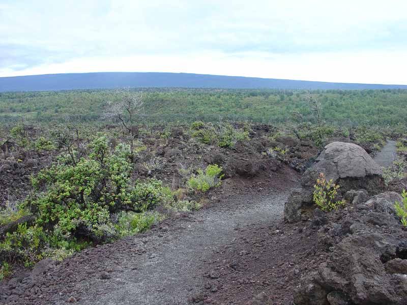
Hawai‘i Volcanoes National Park
Geologic Resources Inventory Report
Natural Resource Report NPS/NRPC/GRD/NRR—2009/163

Geologic Resources Division
Natural Resource Program Center
P.O. Box 25287
Denver, Colorado 80225

December 2009

U.S. Department of the Interior
National Park Service
Natural Resource Program Center
Denver, Colorado
The National Park Service, Natural Resource Program Center publishes a range of reports that
address natural resource topics of interest and applicability to a broad audience in the National
Park Service and others in natural resource management, including scientists, conservation and
environmental constituencies, and the public.

The Natural Resource Report Series is used to disseminate high-priority, current natural
resource management information with managerial application. The series targets a general,
diverse audience, and may contain NPS policy considerations or address sensitive issues of
management applicability.

All manuscripts in the series receive the appropriate level of peer review to ensure that the
information is scientifically credible, technically accurate, appropriately written for the
intended audience, and designed and published in a professional manner. This report received
informal peer review by subject-matter experts who were not directly involved in the
collection, analysis, or reporting of the data.

Views, statements, findings, conclusions, recommendations, and data in this report are those of
the author(s) and do not necessarily reflect views and policies of the National Park Service,
U.S. Department of the Interior. Mention of trade names or commercial products does not
constitute endorsement or recommendation for use by the National Park Service.

Printed copies of this report are produced in a limited quantity and they are only available as
long as the supply lasts. This report is available from the Geologic Resources Inventory website
(http://www.nature.nps.gov/geology/inventory/gre_publications.cfm) and the Natural
Resource Publications Management website (http://www.nature.nps.gov/publications/
NRPM).

Please cite this publication as:

Thornberry-Ehrlich, T. 2009. Hawai‘i Volcanoes National Park Geologic Resources Inventory
Report. Natural Resource Report NPS/NRPC/GRD/NRR—2009/163. National Park Service,
Denver, Colorado.

NPS 124/100623, December 2009
ii NPS Geologic Resources Division
Contents
Figures .......................................................................................................................... iv

Executive Summary ...................................................................................................... v

Introduction ................................................................................................................... 1
  Purpose of the Geologic Resources Inventory ...........................................................................................................1
  Regional Information ..................................................................................................................................................1
  Cultural History and Establishment of Hawai‘i Volcanoes National Park ....................................................................1
  Geologic Setting .........................................................................................................................................................2

Geologic Issues ............................................................................................................. 7
  Volcanism ...................................................................................................................................................................7
  Mass Wasting ........................................................................................................................................................... 10
  Coastal Erosion ........................................................................................................................................................ 10
  Seismicity and Tsunamis .......................................................................................................................................... 11

Geologic Features and Processes ............................................................................. 19
  Mauna Loa and Kīlauea Volcanoes .......................................................................................................................... 19
  Geology and Hawaiian Culture ................................................................................................................................. 22
  Geology and Biology Connections............................................................................................................................ 22

Map Unit Properties .................................................................................................... 28

Geologic History.......................................................................................................... 33
  Pre-Quaternary History of the Pacific Basin ............................................................................................................. 33
  Evolution of the Hawaiian-Emperor Seamount Chain............................................................................................... 33

Glossary ....................................................................................................................... 42

References ................................................................................................................... 45

Appendix A: Geologic Map Graphic .......................................................................... 51

Attachment 1: Geologic Resources Inventory Products CD

                                                                                                          HAVO Geologic Resources Inventory Report                        iii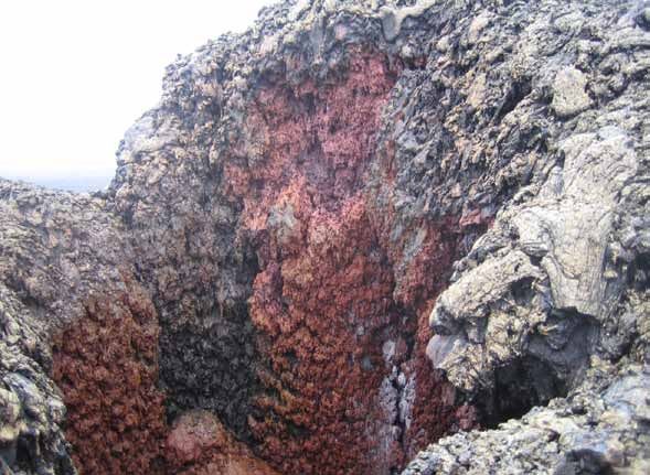
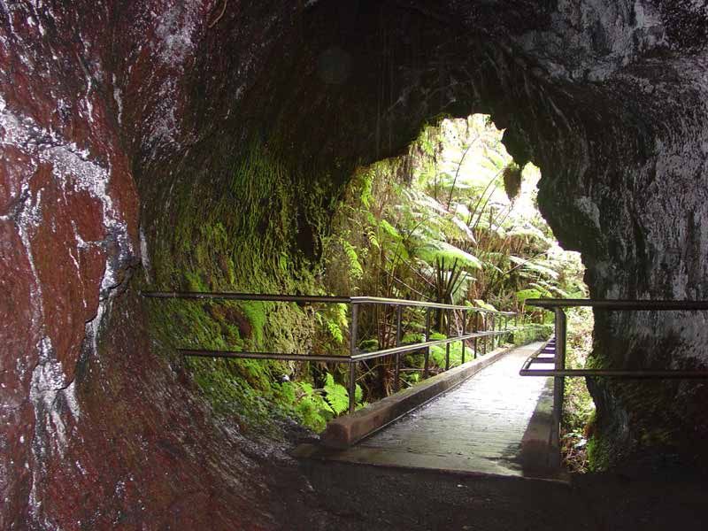
Figures
Figure 1. Map of Hawai‘i Volcanoes National Park ........................................................................................................3
Figure 2. Map of Kīlauea Caldera Area ..........................................................................................................................4
Figure 3. Map of the Island of Hawai‘i and surrounding ocean floor...............................................................................5
Figure 4. Aerial imagery of the northern Pacific Ocean basin ........................................................................................6
Figure 5. View of the Pu‘u ‘Ō‘ō cone of Kīlauea Volcano ............................................................................................. 13
Figure 6. Maps showing volcanic-hazard zones for Mauna Loa and Kīlauea .............................................................. 14
Figure 7. Map showing part of the Puna District near the Pu‘u Ō‘ō vent ...................................................................... 15
Figure 8. View southwest toward ground fissures that emit steam along a trail near Steaming Bluff ........................... 16
Figure 9. View west toward talus cones that mantle the crater wall of Halema‘uma‘u, at Kīlauea Volcano ................. 17
Figure 10. Bathymetric map of the south coast of Hawai‘i showing the locations of the Hilina and Punalu‘u slumps .. 18
Figure 11. Map showing earthquake-hazard zones for the major Hawaiian Islands .................................................... 18
Figure 12. View of Mauna Loa from the Ka‘ū Desert Trail............................................................................................ 23
Figure 13. Aerial oblique view north toward newly created land at Hawai‘i Volcanoes National Park .......................... 24
Figure 14. Aerial oblique view northeast toward new land of an active lava bench...................................................... 24
Figure 15. Solidified lava spatter from fountaining in Hawai‘i Volcanoes National Park ............................................... 25
Figure 16. Molten lava lake within the Pu‘u ‘Ō‘ō vent at Hawai‘i Volcanoes National Park .......................................... 25
Figure 17. Pāhoehoe lava flow that buried the Chain of Craters Road in 1972............................................................ 26
Figure 18. Ropy-textured pāhoehoe and adjacent blocky-textured ‘a‘ā lava flows ....................................................... 26
Figure 19. Secondary mineralization present as delicate sulfur crystals within a surficial cavity of a lava flow ............ 27
Figure 20. View out of the entrance to Thurston Lava Tube ........................................................................................ 27
Figure 21. Geologic time scale ..................................................................................................................................... 36
Figure 22. Geologic time scale of events affecting the Hawaiian Islands throughout the Cenozoic Era ...................... 37
Figure 23. Generalized arrangement of plates in the Pacific Ocean basin during the middle Cretaceous ................... 38
Figure 24. Map of the current tectonic plates ............................................................................................................... 38
Figure 25. Evolution of a chain of islands over a stationary hotspot in Earth’s crust .................................................... 39
Figure 26. Location of hotspots across the South Pacific............................................................................................. 40
Figure 27. Simplified stages of Hawaiian hotspot island volcanism ............................................................................. 41

iv    NPS Geologic Resources Division

Executive Summary
This report accompanies the digital geologic map for Hawai‘i Volcanoes National Park in
Hawai‘i, which the Geologic Resources Division produced in collaboration with its
partners. It contains information relevant to resource management and scientific research.
This document incorporates preexisting geologic information and does not include new data
or additional fieldwork.
Hawai‘i Volcanoes National Park is truly a place to             Relative sea level rise is locally high because of crustal
experience geology first hand. Dynamic geologic                 loading from the active volcanic masses and relatively
processes of volcanism, mass wasting, and seismicity are        little removal of material by erosional processes.
changing the landscape on a dramatically short time           • Seismicity and tsunamis.
scale. Native Hawaiians’ oral traditions demonstrate a          Seismicity is a concern throughout the Pacific Ocean
reverence for, and understanding of, the natural world.         basin. Earthquakes occur frequently on Hawai‘i as a
The geology on display at the park forms the foundation         result of magma movement accompanying volcanism,
for myriad ecosystems and provides invaluable research          as well as crustal stresses arising from areas of
opportunities in scientific fields such as volcanology,         structural weakness and crustal loading by the volcanic
seismology, and speleology. The park strives to protect         mass. Seismic activity has caused fatalities, ground
and preserve its unique environment while educating             rupture, localized uplift or subsidence, liquefaction,
and providing safe access to more than a million visitors       ground settling, and extensive damage to roads,
each year.                                                      buildings and homes, and it has triggered tsunamis.
                                                                The coastal areas of Hawai‘i are susceptible to
Geology is fundamental to the management of the scenic,         inundation during tsunamis. Interagency cooperators
natural, and cultural resources of the park. Geology            work to predict and warn populated areas of potential
contributes to climate, natural hazards, hydrology, and         tsunami threats. Tsunami modeling considers all
topography. Geology also strongly influenced the Native         seismic events, bathymetry, storms, wind, and rain.
Hawaiian and early establishment history at the park.
Geologic issues of particular significance for resource
management at Hawai‘i Volcanoes National Park                 The scenic and cultural resources of the park are closely
include:                                                      linked to its geologic features and processes. This theme
                                                              is a potential interpretive topic. Kīlauea and Mauna Loa,
• Volcanism.                                                  with their volcanically active summits and rift zones, are
  Kīlauea and Mauna Loa volcanoes crown Hawai‘i               the primary geologic features of the park. The ongoing
  Volcanoes National Park. These volcanoes are among          eruption of Kīlauea is providing invaluable insights into
  the most active in the world. Volcanic hazards include      lava-flow mechanics, hazard-zone assessment, and
  lava-flow inundation, forest fires, pyroclastic ejection,   volcanic evolution of a Hawaiian island. Eruptions
  noxious gases, and lava-tube collapse. Scientists in        pumping lava downslope in lava tubes are adding new
  cooperative networks are working to understand and          land to the island at rates of 4–70 ha/year (hectares)
  predict volcanic activity to best protect park resources    (10–170 acres). The vast network of lava tubes on the
  and human safety. The process of active volcanism at        flanks of Mauna Loa and Kīlauea are a treasure for
  Kīlauea Volcano creates hazy “vog” that comprises           speleologists. Many new and transient lava tubes and
  acidic aerosols, unreacted sulfur gases, and volcanic       other flow features are type localities at the park. Other
  ash and other fine particulate matter. This vog             features and processes of interest at Hawai‘i Volcanoes
  periodically obscures the vistas at the park.               National Park include connections with biology and
• Mass wasting.                                               Hawaiian culture.
  Steep slopes, ground water and surface water flow,
  and frequent seismic activity create a setting prone to     Knowing the physical properties of the different geologic
  mass wasting. Mass wasting threatens visitor safety         units mapped at Hawai‘i Volcanoes National Park is
  and buries local habitat, increases erosion, and            important to managing the natural and cultural resources
  disrupts the hydrologic system. There is a continuum        throughout the park. The table of map unit properties
  between two main types of slope failures at the park:       includes characteristics such as erosion resistance,
  large, slow-moving slumps, and narrow, fast-moving          suitability for infrastructure development, geologic
  debris avalanches. The Hilina slump covers most of          significance, recreation potential, and associated cultural
  the southern flank of Kīlauea Volcano. The largest          and mineral resources for each mapped geologic unit. In
  slides, which extend offshore, could cause local            addition to their physical properties, the rock units and
  tsunamis.                                                   active geologic processes at Hawai‘i Volcanoes National
                                                              Park provide information related to the evolution of
• Coastal erosion.
                                                              volcanic islands and the geologic history of the
  Coastal erosion affects the shoreline at the park,
                                                              Hawaiian-Emperor volcanic island and seamount chain
  causing potential loss of natural and cultural resources.
                                                              in the Pacific Ocean basin.
  Coastal erosion is a function of numerous factors.

                                                                         HAVO Geologic Resources Inventory Report v
Introduction
The following section briefly describes the National Park Service Geologic Resources
Inventory and the regional geologic setting of Hawai‘i Volcanoes National Park.
Purpose of the Geologic Resources Inventory                   Regional Information
The Geologic Resources Inventory (GRI) is one of 12           Located on the southern end of the Island of Hawai‘i, the
                                                                                                                   2
inventories funded under the National Park Service            Hawai‘i Volcanoes National Park covers 1,348 km
                                                                      2
(NPS) Natural Resource Challenge designed to enhance          (520 mi ), an expanse that includes the 2003 acquisition
                                                                                          2
baseline information available to park managers. The          of Kahuku Ranch (469 km , 115,788 acres) (figs. 1 and 2)
                                                                                                                        2
program carries out the geologic component of the             (National Park Service 2009). Of the total area, 530 km
                                                                      2
inventory effort. The Geologic Resources Division of the      (205 mi ) is in wilderness status (National Park Service
Natural Resource Program Center administers this              2009). The Island of Hawai‘i covers an area of about
                                                                         2          2
program. The GRI team relies heavily on partnerships          10,432 km (4,028 mi ) and is the largest and youngest of
with the U.S. Geological Survey, Colorado State               the seven main Hawaiian Islands (fig. 3). The Hawaiian
University, state geologic surveys, and others in             archipelago contains 18 islands, reefs, shoals, atolls, and
developing GRI products.                                      pinnacles, the smallest of which, Gardner Pinnacle, is
                                                              only about 1 ha (hectare) (2.5 acres). Hawai‘i lies
The goal of the GRI is to increase understanding of the       southeast of the neighboring Island of Maui, separated
geologic processes at work in parks and provide sound         by the 48-km- (30-mi-) wide ‘Alenuihāhā Channel, and is
geologic information for use in park decision making.         the southeasternmost landmass of the Hawaiian island
Sound park stewardship relies on understanding natural        chain. Hawai‘i is more than 3,500 km (2,200 mi) from the
resources and their role in the ecosystem. Geology is the     nearest continent, North America.
foundation of park ecosystems. The compilation and use
of natural resource information by park managers is           The Island of Hawai‘i is split geographically and
called for in section 204 of the National Parks Omnibus       ecologically into many areas and contains three
Management Act of 1998 and in NPS-75, Natural                 volcanoes that have erupted in the past 200 years:
Resources Inventory and Monitoring Guideline.                 Kīlauea, Mauna Loa, and Hualālai. The highest point on
                                                              the island is the summit of Mauna Kea volcano, 4,205 m
To realize this goal, the GRI team is systematically          (13,797 ft) in elevation.
conducting a scoping meeting for each of the identified
270 natural area parks and providing a park-specific          Cultural History and Establishment of Hawai‘i
digital geologic map and geologic report. These products      Volcanoes National Park
support the stewardship of park resources and are             The climate at Hawai‘i Volcanoes is diverse, from the
designed for nongeoscientists. Scoping meetings bring         dry, high-elevation crater summit areas to the temperate
together park staff and geologic experts to review            western slopes and to the wet, tropical eastern slopes.
available geologic maps and discuss specific geologic         The earliest human inhabitants took advantage of this
issues, features, and processes.                              varied environment, and evidence of their presence dots
                                                              the landscape at Hawai‘i Volcanoes National Park. Lava-
The GRI mapping team converts the geologic maps               tube caves served as habitation sites, shelters in times of
identified for park use at the scoping meeting into digital   war, storage places for food, and work areas. Ritual sites
geologic data in accordance with their Geographic             were an integral part of a highly advanced religious
Information Systems (GIS) Data Model. These digital           society. Facets of this religion were defined in the kapu
data sets bring an interactive dimension to traditional       (laws of conduct). In old Hawai‘i, kapu governed all
paper maps by providing geologic data for use in a park       aspects of society. Penalties were severe and quick. After
GIS and facilitating the incorporation of geologic            1819, Hawaiians discontinued the kapu system and old
considerations into a wide range of resource                  religions. Hawai‘i Volcanoes National Park strives to
management applications. The newest maps come                 demonstrate the intimate balance and spiritual
complete with interactive help files. This geologic report    connections between the early Hawaiians and their
aids in the use of the map and provides park managers         surrounding natural environment.
with an overview of park geology and geologic resource
management issues.                                            Hawai‘i Volcanoes National Park protects a variety of
                                                              ecosystems, including tropical rainforest on the
For additional information regarding the content of this      windward northern and eastern slopes, protected niches
report and current GRI contact information please refer       within old craters, arid desert on the leeward southern
to the Geologic Resources Inventory Web site                  and western slopes, and subalpine to alpine
(http://www.nature.nps.gov/geology/inventory/).               environments at higher altitudes. Each ecosystem hosts
                                                              flora and fauna uniquely suited to that area, and ancient
                                                              Hawaiians found ways to use every environment.

                                                                         HAVO Geologic Resources Inventory Report 1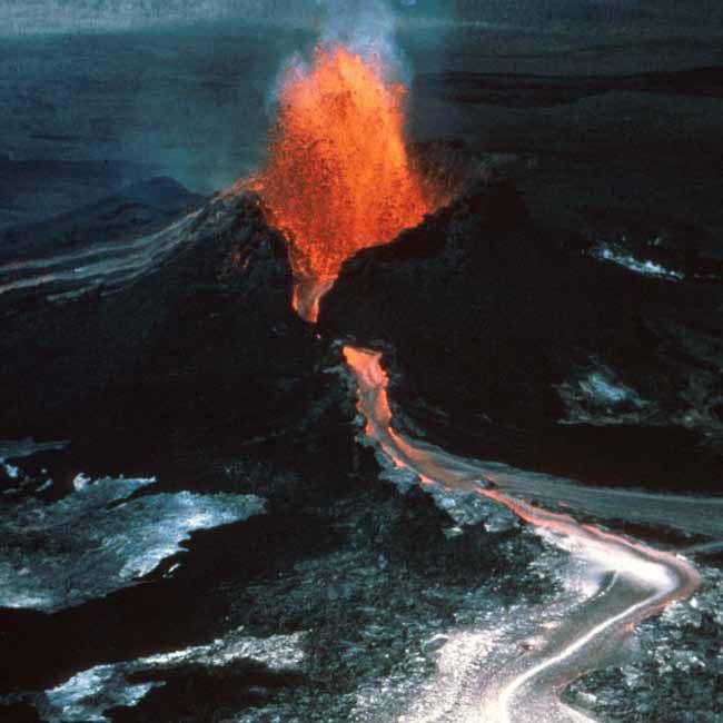
Hawai‘i Volcanoes National Park, when first established        From east to west, the Hawaiian Islands increase in age,
on August 1, 1916, was part of Hawai‘i National Park.          degree of erosion, and subsidence into the sea.
The establishment of the park followed years of
pioneering, road building, exploring by early settlers and     Several of the islands are built by more than one
visitors to the area beginning in the mid-1800s and the        volcano.The Island of Hawai‘i encompasses five major
evolution of Volcano House Hotel. In 1903, one of these        shield volcanoes: Kohala, Mauna Kea, Hualālai, Mauna
visitors, William R. Castle, noted that the U.S.               Loa, and Kīlauea (fig. 3). The latter two are among the
Government should reserve the region from Mauna Loa            most active volcanoes in the world. Hawai‘i Volcanoes
to Puna. The original Hawai‘i National Park was divided        National Park includes the summits of Mauna Loa and
and renamed on September 22, 1961, with its parts              Kīlauea, the active eruption area (Pu‘u ‘Ō‘ō vent), stark
becoming Hawai‘i Volcanoes and Haleakalā national              volcanic flow fields, and numerous small craters. The
parks. The wilderness within Hawai‘i Volcanoes                 majority of lava flows and vent deposits in the park are
National Park was designated on November 10, 1978,             younger than 750 years, and volcanic rocks dominate the
and the park was recognized as a Biosphere Reserve in          geology of the park. Kīlauea has been erupting almost
1980. Hawai‘i Volcanoes National Park preserves a              nonstop since January 3, 1983.
variety of landforms, from erupting volcanic vents to
seashores to the volcanic summit, fragile native Hawaiian      The landscape within Hawai‘i Volcanoes National Park
ecosystems, and prehistoric cultural sites.                    consists of the relatively stark, rugged fresh lava flow
                                                               areas, Kīlauea Crater, Mauna Loa’s gentle slopes, and
Additional park information may be found at                    coastal areas where basalt flows form broad, sloping
http://www.nps.gov/havo, the Hawai‘i Volcanoes                 benches or terraces separating sheltered coves along the
National Park Web site.                                        shore several meters below. Sparse beach areas include
                                                               intertidal to supratidal accumulations of black sand,
Geologic Setting                                               olivine green sand, and some coralline sediment from
Hawai‘i is just one volcanic island among the many             storms and marine highstands throughout the Holocene,
subaerial islands and submarine seamounts of the               as well as eolian deposits of fine sand. Natural features
Hawaiian-Emperor volcanic chain (fig. 4). The chain            include barren, lava-inundated landscapes, ephemeral
stretches over 5,800 km (3,600 mi) from the Aleutian           streams cutting narrow gorges, fresh volcanic deposits,
trench in the northwest Pacific Ocean basin to Lō‘ihi          cinder cones and craters, broad vegetated slopes, and a
seamount, which is approximately 35 km (22 mi) off the         variety of unique and native Hawaiian ecosystems. Soil
southeast coast of the Island of Hawai‘i (fig. 3). The chain   development is stunted at the higher elevations or where
formed due to the movement of the Pacific tectonic plate       there have been recent eruptions.
over an essentially stationary hotspot of volcanic activity.

2 NPS Geologic Resources Division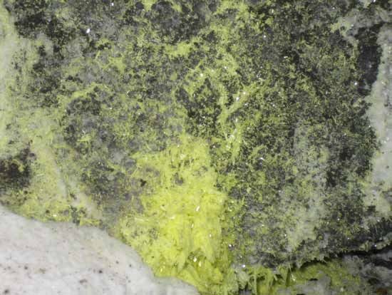
Area of
figure
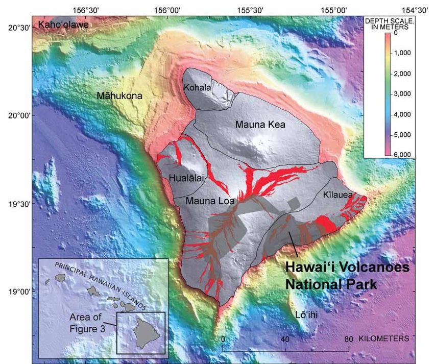
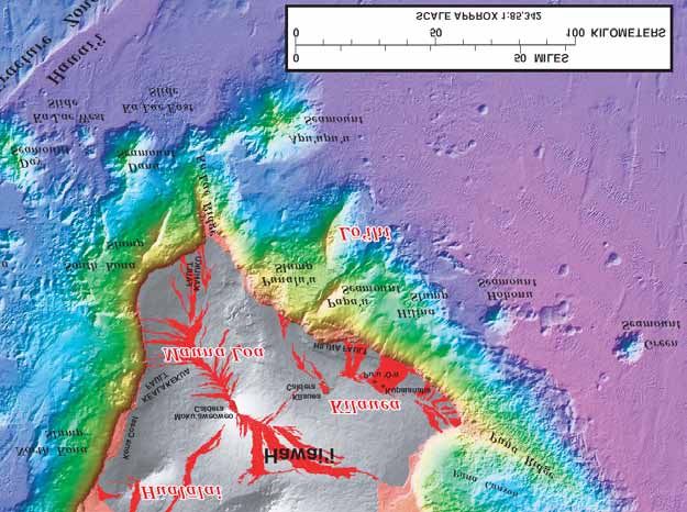
Figure 3. Map of the Island of Hawai‘i and surrounding ocean floor. Note locations of the five volcanic centers on the island as well as
benthic (sea floor) morphology. Gray areas are exposed land; red areas are historical lava flows. USGS graphic excerpted from map by
Eakins and others (2003).
HAVO Geologic Resources Inventory Report 5Figure 4. Aerial imagery of the northern Pacific Ocean basin, with deeper areas appearing dark blue to black and the Hawaiian-Emperor volcanic chain (and other relatively shallow areas) visible as lighter blue areas. The white box encloses the Hawaiian Islands. The white arrow indicates present motion of the Pacific plate at 95 mm/year (3.74 inches/year). Compiled by Jason Kenworthy (NPS Geologic Resources Division) from ESRI Arc Image Service, USA Prime Imagery with information from Eakins and others (2003). 6 NPS Geologic Resources Division
Geologic Issues
The National Park Service held a Geologic Resources Inventory scoping session for
Hawai‘i Volcanoes National Park on March 20, 2003, to discuss geologic resources,
address the status of geologic mapping, and assess resource management issues and
needs. This section synthesizes the scoping results, in particular those issues that may
require attention from resource managers.
The primary resource management emphasis at Hawai‘i            thermal heating. Heliker (1990) presents a thorough
Volcanoes National Park is preserving and protecting a         overview of hazards associated with volcanism and
variety of ecosystems and unique volcanic features on          seismicity, including abundant photographs, in detail
Mauna Loa and Kīlauea, as well as protecting and               that is beyond the scope of this report. Additionally, Hon
ensuring access for visitors. Natural resource                 and others (2008) prepared a field interpretation of
management goals at Hawai‘i Volcanoes National Park            active volcanoes intended as a handbook for viewing lava
include better understanding of volcanic processes and         that could provide a useful reference for resource
reducing the impact of park activities on the                  managers at Hawai‘i Volcanoes National Park.
environment while providing educational access for
visitors and complementing the preservation of cultural        Due to the dynamic nature of the landscape on active
landscape.                                                     volcanoes, conditions or events are unpredictable and
                                                               can change on a daily basis (Hon et al. 2008). In general,
Hawai‘i is the only state in the United States that is         Hawaiian lava flows are considered among the most
subject to earthquakes, volcanism, tsunamis, and               approachable in the world; however, molten lava is
hurricanes. The dynamic nature of the geomorphic               extremely dangerous material—hot and moving (Hon et
processes at work on the Hawaiian landscape, including         al. 2008). Flows from Mauna Loa have reached distances
coastal erosion, rise in sea level, seasonal high waves, and   of 50 km (30 mi) or more. While lava generally flows
stream erosion (Richmond et al. 2001), increases the           slowly enough to allow people and animals to escape,
importance of sound knowledge of the physical world            anything remaining in the path of a flow (such as rare
underlying the tropical ecosystem. This section discusses      rainforest, historical sites, or communities) will be
the management of natural resources, focusing on the           damaged or destroyed by burial, crushing, or ignition
most important geologic issues at the park.                    (Rutherford and Kaye 2006). The ejection of pyroclastic
                                                               materials (cinder or spatter cones) has a similar impact,
Many natural phenomena pose threats to populated               but the spatial extent of the effect is limited to near the
areas of the Hawaiian Islands. Among these hazards are         vent.
volcanism, mass wasting, coastal erosion, seismic activity,
and tsunami inundation. Local slopes and geologic              Eruptions are usually preceded and accompanied by
settings must be taken into account to accurately              seismic and volcanic unrest, as well as by the appearance
determine potential hazards for a specific area, such as       of cracks in the ground (Crandell 1983). This unrest is
Hawai‘i Volcanoes National Park (Richmond et al. 2001).        expressed by earthquakes and by variations in the
Important tools in hazard assessment include records of        geophysical and gas-geochemical state of the volcanic
past events and their magnitude, in addition to accurate       system. Analysis of 52 historic eruptions supports an
inventorying and regular monitoring of current                 intriguing idea that stresses caused by fortnightly earth
conditions. Detailed geologic mapping provides an              tides play a significant role in triggering volcanic activity
additional tool, linking underlying geology to specific        at Kīlauea Volcano. Since 1832, nearly twice as many
hazards.                                                       eruptions have occurred near the tidal maximum than
                                                               near the minimum. Stresses induced by fortnightly earth
Volcanism                                                      tides acting in concert with volcanic and tectonic stresses
Hawai‘i Volcanoes National Park contains two of the            along preexisting zones of weakness could trigger these.
most active volcanoes on Earth: Kīlauea (erupting since        The same correlation was not found as definitively for
January 3, 1983) and Mauna Loa (last erupted March             Mauna Loa volcano, possibly due to differences in
1984, with a recurrence interval of approximately 5 years      structure and internal plumbing (Dzurisin 1980).
since 1843) (Lockwood and Lipman 1987; U.S.
Geological Survey 2006, 2009a). During the past 25 years,      When Kīlauea Volcano began erupting in 1983, the
volcanism at Kīlauea has been an almost-daily                  activity soon settled at a single vent to form the Pu‘u ‘Ō‘ō
occurrence in the park, pumping lava downslope in lava         cone (fig. 5). Flows from this vent inundated the Royal
tubes and adding new land to the island at rates of            Gardens subdivision, destroying 16 residences. The
4–70 ha/year (10–170 acres/year) (Heliker and Mattox           eruptive center then shifted downrift, and a tube system
2003). Associated with active volcanism are several areas      developed, transporting lava to the sea. By the end of
of concern: lava eruption and destruction associated           1990, the Kalapana community was completely overrun
with flows, ejection of pyroclastic material, collapse of      and more than 100 residences were destroyed (Heliker
lava tubes, corrosive volcanic gases, and subsurface           and Wright 1992). The park’s Wahaula Visitor Center

                                                                          HAVO Geologic Resources Inventory Report 7
was overrun and destroyed in 1989. Lava continues to both risk and hazard. This has applications for land-use
claim abandoned homes in Royal Gardens, including one planning because more accurate predictions of direction
in July 2009 (Honolulu Star-Bulletin 2009). and advance rate of lava flows are made possible in the
form of maps of lava sheds and preferred-gravitational-
The U.S. Geological Survey's Hawaiian Volcano flow paths (Kauahikaua et al. 2003).
Observatory (HVO) has, for the islands of Hawai‘i and
Maui, an extensive monitoring system for surface and Lava-flow hazard zones, mapped on the basis of location
subsurface deformation, seismicity, and volcanic of eruptive vents, past lava coverage, and topography,
emissions. Since its inception, HVO has been indicate that most of Hawai‘i Volcanoes National Park
instrumental in short-term forecasting of eruptive lies within a very hazardous area (Wright et al. 1992).
activity at Kīlauea, and its role in park management is Areas most likely to be inundated by lava include those
vital (Gebhart 1983). The HVO is part of a cooperative near active rift zones, downslope areas within the lava
effort with the Center for the Study of Active Volcanoes sheds (analogous to watersheds) of rift zones, and areas
(CSAV) and with institutions such as the University of where lava is channeled by topographic features (fig. 6).
Hawai‘i and Stanford University to understand volcanic Topographic obstructions also define areas at low risk of
processes and attempt to lessen their potential threats to being inundated by lava flows, and large-scale mapping is
society (Rutherford and Kaye 2006). The HVO works necessary to delineate these sheltered areas. On Kīlauea
carefully with the Hawai‘i County Civil Defense Agency Volcano, population density has increased in the lower
and Hawai‘i Volcanoes National Park to provide timely east rift zone. Should vent activity shift farther down the
information on location and movement of lava flows to rift, future eruptions could pose hazards for these
guide decisions regarding road closures, evacuations, populations. Since 1960, the population in high hazard
safe tourist viewing, and mitigation attempts (Heliker et zones on Kīlauea’s flanks has more than quadrupled
al. 1986; Heliker and Wright 1992). Given the nearly (Heliker and Wright 1992).
continuous nature of lava eruption at Kīlauea, site-
specific studies of lava-flow dynamics, thermal lava-flux As volcanic activity evolves and shifts on the flanks of
monitoring, and lava-flow and lava-tube mapping are Kīlauea and Mauna Loa, park resource managers must
improving lava-flow hazard assessments and mitigation be prepared to address potential hazards within the park
tools (Kauahikaua et al. 2003). and perhaps participate in cooperative efforts to assess
hazards from lava flowing into surrounding areas. Since
Though no two eruptions begin in exactly the same way, volcanic activity began in 1983, eruption sites have
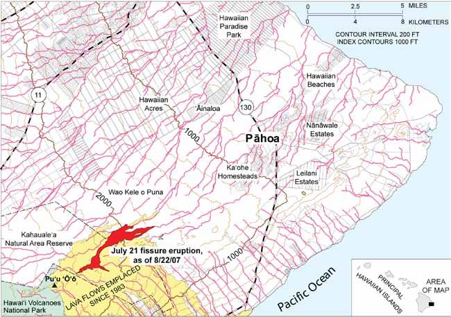
the most reliable precursors to eruptions in Hawai‘i have shifted along the east rift zone (Heliker et al. 2003).
been seismic activity and ground deformation as magma Sporadically, eruptions from the Pu‘u ‘Ō‘ō–Kupaianaha
enters the summit reservoir and is discharged at the vents have flowed north of the east rift zone, most
summit or along one of the rift zones. Seismic swarms recently in 2007 (fig. 7). Changes in eruptive behavior
often migrate ahead of the intruding magma (Heliker could cause future flows to advance downrift and impact
1988). The observatory has real-time GPS receivers communities in the Puna district that have thus far been
throughout the park, and HVO staff periodically unaffected by lava flows of the Pu‘u ‘Ō‘ō–Kupaianaha
conducts leveling, electronic distance measurement, and eruption. However, several of these communities were
dry tilt surveys (Rutherford and Kaye 2006). These impacted by previous eruptions in the 1960s (D. Sherrod,
measurements, as well as infrared imagery from the U.S. Geological Survey, written communication 2009).
geosynchronous-orbiting environmental satellite As of 2007, lava flows posed no immediate threats to any
(GOES), Landsat imagery, and telemetered video, are communities (Kauahikaua 2007). Potential lava-flow
useful to determine lava-flow spread (Kauahikaua et al. paths are estimated by calculating the path of steepest
2003). descent from a digital elevation model for the area in
question (fig. 7). Since lava flows change local
The frequent monitoring of the long-lived eruptive topography, the paths of steepest descent are always
activity provides basis for comparison with previous changing over the course of an eruption. The potential
conditions and an invaluable record of ground for inundation by a lava flow warrants increased public
deformation patterns associated with active volcanism. awareness and enhanced monitoring (Kauahikaua 2007).
Further techniques are being discussed and developed to Wright and others (1992) assessed long-term lava-flow
monitor the lava output from Pu‘u ‘Ō‘ō. These hazards for the Puna district, and their work is still
techniques and data sets include (1) topographic considered a useful tool in predicting the locations at risk
(elevation) data over the entire flow field, (2) passive of inundation during lava eruptions.
seismic listening or active ultrasound probing, (3)
combining short-range remote sensing (hand-held Open Cracks and Fragile Ground
multispectral imagers or interferometric radar) with Ground movement frequently accompanies volcanism
ground-based observations, (4) real-time telemetered due to shallow underground movement of magma. This
information from tube-flux monitors, microphones, and movement may result in large cracks across roads, trails,
stationary video monitors with infrared sensors, and (5) and other park infrastructure, and can compromise
time-lapse videography from oblique angles (Kauahikaua building foundations and road subgrades (fig. 8; Heliker
et al. 2003). 1990; D. Sherrod, U.S. Geological Survey, written
communication 2009). Cracks and settling tend to occur
Understanding eruptive mechanics helps mitigate future in close proximity to active or recently active volcanic
volcanic hazards by supporting more precise estimates of
8 NPS Geologic Resources Divisionvents, and cracking may be due to seismic activity or may throughout the island attest to even larger explosive
precede an eruption at a new site as magma is forcefully eruptions in prehistoric times (Heliker 1990)
injected into the subsurface (Heliker 1990; Hon et al.
2008). Prior to eruptions in the Kapoho area on Kīlauea’s Nearly ubiquitous with active volcanism is the emission
lower east rift zone in 1924, 1955, and 1960, ground of volcanic gases and steam. A gas plume rising from an
cracks as much as 2 m (7 ft) wide and more than 1.6 km active vent on Kīlauea consists of approximately 80%
(2 mi) long rapidly formed (Heliker 1990). Because of water vapor; lesser amounts of sulfur dioxide, carbon
their rapid and unpredictable formation, and the fact dioxide, and hydrogen; and minute amounts (less than
that they can be obscured by heavy vegetation, ground 1% by volume) of carbon monoxide, hydrogen sulfide,
cracks pose a significant threat to visitor safety at Hawai‘i and hydrogen fluoride (Heliker 1990). Part of Kīlauea
Volcanoes National Park (Heliker 1990; Hon et al. 2008; Crater was closed briefly in the early to middle 2000s
D. Sherrod, U.S. Geological Survey, written because of concern about toxic accumulations of carbon
communication 2009). dioxide (CO2) (D. Sherrod, U.S. Geological Survey,
written communication 2009). In many areas accessible
Fragile ground associated with the existence of shallow along the Crater Rim Drive of Kīlauea Volcano, steam
lava tubes and shelly pāhoehoe (characterized by fragile vents pose a burn hazard for visitors (D. Sherrod, U.S.
gas cavities, small tubes, and buckled fragments of Geological Survey, written communication 2009).
surface crust [Swanson 1973]) poses threats to the
integrity and safety of roads and trails (D. Sherrod, U.S. Emitting roughly 1,500 tons of toxic sulfur dioxide gas
Geological Survey, written communication 2009). (SO2) each day (Elias and Sutton 2002), Kīlauea Volcano
Shallow tubes can collapse, and cavities with thin upper is the largest stationary source of SO2 in the United States
crusts or shells can break, creating sharp edges and fall (fig. 9). The Environmental Protection Agency’s
hazards for visitors. Kīlauea is underlain mostly by guideline for industrial pollution is 0.25 tons of SO2
hummocky, tube-fed pāhoehoe. Surface crusts can be emitted per day (Gibson 2001). Taken weekly with a
less than 5 cm (2 in.) thick and cannot support much correlation spectrometer, SO2 emission rate
weight, so they are treacherous underfoot (Swanson measurements at Hawai‘i Volcanoes National Park date
1973). Studied during the Mauna Ulu eruptions of the back to 1979—an unusually complete data set.
1970s, shelly pāhoehoe occurs where gas-charged (or Carbon/sulfur ratios are also monitored on a weekly
inflated) lava wells out of the source fissure with little or basis at the park (Rutherford and Kaye 2006). Air quality
no accompanying fountaining (Swanson 1973). The is continuously monitored, with information accessible
pressure of expanding gas within the flow lobes during on a National Park Service Air Resources Division Web
cooling is sufficient to expand the plastic crust upward site: http://www.nature.nps.gov/air/webcams/parks/
like a balloon (Swanson 1973). Knowing under what havoso2alert/havoalert.cfm (accessed December, 2009).
conditions this type of flow develops can help prevent
accidents for park visitors. Sulfur dioxide may combine with acid aerosols and fine
particulates that form when volcanic and trace species
Airborne Hazards and Steam react and become oxidized in the air. The result is a hazy
Although lava flows are the most common hazards atmosphere known as “vog” (Elias and Sutton 2002). Vog
directly associated with volcanic activity and pose the (“volcanic smog”) can affect spatial and temporal trends
greatest threat to property, another issue associated with in precipitation and surface temperatures (Gibson 2001).
active volcanism in the vicinity of Hawai‘i Volcanoes Sulfate aerosols have a surficial cooling effect locally due
National Park is airborne volcanic emissions of ash, to the scattering of incoming radiation, and vog acts as
gases, and steam (condensed water vapor) (Heliker nuclei for condensation in the formation of clouds. The
1990). Ejection of airborne “tephra” (particles of ash), presence of heavy vog correlates locally with reduced
cinder, and fragile strands of volcanic glass (called rainfall (Gibson 2001). Rainfall in turn has the potential
“Pele’s hair”) accompanies most Hawaiian eruptions and to reduce sulfur species in the air, for example reducing
can cause irritation for people with respiratory problems SO2 30%–80% (Michaud et al. 2007).
and clog rainwater catchment systems (Heliker 1990).
Tephra is usually a hazard only in the immediate vicinity Depending on wind conditions, vog from Kīlauea can be
of an erupting vent, but high lava fountains combined problematic all across southern Hawai‘i. During
with strong prevailing winds have carried tephra great particularly active eruptive periods and in the absence of
distances. Kona winds (high winds associated with rain prevailing winds, vog can stretch as far as O‘ahu, some
and storms, blowing the opposite direction of the trade 350 km (220 mi) northwest of Kīlauea. Elevated SO2
winds) during fountaining episodes at the Pu‘u ‘Ō‘ō vent levels at Hawai‘i Volcanoes National Park tend to occur
from 1984 to 1986 deposited tephra on the town of Hilo during the daytime between November and March
some 35 km (22 mi) away (Heliker 1990). Rarer explosive (Michaud et al. 2007), when prevailing northeasterly
eruptions have the potential to produce pyroclastic trade winds subside and southerly winds periodically
surges, which are highly destructive, turbulent gas clouds blow the fume inland (D. Sherrod, U.S. Geological
that flow rapidly along the ground and contain mixtures Survey, written communication 2009). Volcanic
of hot ash and rock fragments (Heliker 1990). An emissions can destroy surrounding vegetation through
explosive eruption in 1790 caused 80 fatalities from a large amounts of emitted carbon dioxide, sulfur dioxide,
pyroclastic surge, and thick ash deposits exposed and hydrochloric and hydrofluoric acids (Rutherford
and Kaye 2006; Michaud et al. 2007). These emissions
acidify soils, lower rainfall pH (forming acid rain), and
HAVO Geologic Resources Inventory Report 9increase the proportion of heavy metals in soils and Hilina slump covers most of the southern flank of
surface water (Heliker 1990; Gibson 2001). Acid rain in Kīlauea Volcano, and the Punalu‘u slump stretches over
turn can leach lead from roof flashings, nails, and solder a broad area of Mauna Loa’s southern flank (Clague and
connections, and pose additional hazards for Denlinger 1993; Lipman et al. 2000). These slides extend
contamination of drinking water and soils (Heliker offshore to great depths and could fail to such an extent
1990). as to cause local tsunamis (fig. 10).
During particularly fume-rich periods, closures of Another type of mass wasting found at Hawai‘i
certain facilities of Hawai‘i Volcanoes National Park are Volcanoes National Park is debris avalanche (also called
necessary to protect visitors from noxious gases. The “volcanic landslides”). Debris avalanches are gravity-
major components of vog can have adverse effects on driven, fast-moving mixtures of soil and bedrock that
human respiratory and pulmonary function. The Island originate when slumps accelerate downslope,
of Hawai‘i leads the state in asthma death rate, one of the disaggregate, and transform to chaotic mixtures (Wright
highest asthma death rates in the United States. The U.S. and Pierson 1992; D. Sherrod, U.S. Geological Survey,
Geological Survey and the National Park Service written communication 2009). They can occur in
cooperate in monitoring the volcanic emissions and air association with eruptions, heavy rainfall, or a large
quality to inform park managers through a color-coded earthquake (Wright and Pierson 1992). The resulting
advisory system of appropriate times to limit access or to deposits, which extend downslope from well-defined
close facilities completely (Elias and Sutton 2002). Refer amphitheaters at their headwalls, typically are long,
to the Air Resources Division Web site for near real-time narrow (0.5–2.0 km, or 0.3–1.24 mi), and hummocky
air quality data (http://www.nature.nps.gov/air/ (lumpy) in the lower lobe. Famous Hawaiian examples of
webcams/parks/havoso2alert/havoalert.cfm, accessed debris avalanches occur on the Island of Moloka‘i.
December 2009).
Mass wasting can occur as topples in coastal areas where
Mass Wasting the cliffs literally tip over (D. Sherrod, U.S. Geological
Mass wasting is a significant resource management issue Survey, written communication 2009). In coastal areas
at Hawai‘i Volcanoes National Park due to the dynamic where the growing edge of a lava bench covers a pile of
environment there. Relatively little information on fragmented lava to form a type of delta, an illusion of
erosion and mass wasting exists for Hawai‘i. Locally stability is created. This situation is exacerbated by
steep slopes, combined with flow of ground and surface violent and dangerous steam-driven explosions where
water and frequent seismic episodes, create a setting molten lava interacts with cold sea water. Also, bubble
prone to mass wasting by processes such as landsliding, bursts can occur inland of the leading edge of the new
mud flows, or slope creep (Rutherford and Kaye 2006). land if the delta subsides and allows sea water to infiltrate
Affected areas include edges of volcanic craters and pits, the lava-tube system (Hon et al. 2008). When wave action
some of which are near visitor facilities (fig. 8). Talus erodes the fragmented material beneath the new land,
cones (fig. 9) and slope collapses occur in pit craters and the pile becomes over-steepened and can collapse
caldera walls (D. Sherrod, U.S. Geological Survey, catastrophically (Hon et al. 2008). If the event is large
written communication 2009). enough, it can become a submarine landslide (Hon et al.
2008).
The nearly constant threat of seismic activity only
increases the likelihood of rockfall and other mass Coastal Erosion
wasting. During a 1983 earthquake, segments of park According to the 2004 mapped boundary, Hawai‘i
roads were lost into Kīlauea Iki. However, some mass- Volcanoes National Park protects some 52 km (32 mi) of
wasting processes are more continuous in nature. The coastal environment on the southern side of the Island of
Chain of Craters road was relocated in the late 1990s Hawai‘i (D. Sherrod, U.S. Geological Survey, written
because the walls of an adjacent pit crater were slowly communication 2009). The coastline at the park is almost
expanding outward by piecemeal collapse and entirely a low cliff carved into lava flows, with shifting
encroaching on the roadway (D. Sherrod, U.S. narrow sand or boulder beaches at the cliff foot.
Geological Survey, written communication 2009). Mass
wasting buries local habitat, increases erosion, disrupts Erosion of the coast may lead to loss of cultural
the hydrologic system, and, if the event is large enough, resources and instability of lava benches, inundation,
can cause tsunamis. damage to benthic habitats (such as shallow coral reefs),
and increased sediment load. Average erosion rates in
In Hawai‘i, there is a continuum between two main types the Hawaiian Islands are approximately 15-30 cm/year
of slope failures: slumps and debris avalanches. Slumps (0.5-1 ft/year) (Richmond et al. 2001). Many factors are
(also called “slides”) can be very large in area (as much as involved in coastal evolution and vulnerability to
40 km, or 25 mi, wide and 10 km, or 6 mi, deep) and have erosion, including tidal range, wave height, coastal slope,
internal transverse ridges and steep toes. Slumps can historic rates of shoreline change, geomorphic features,
occur abruptly or over a long time span (D. Sherrod, U.S. and relative change in sea level. Tidal range and wave
Geological Survey, written communication 2009). Some height are linked to inundation hazards. Tsunamis, a
of these slides are marked by headwall cliffs (pali), such significant hazard in the Hawaiian Islands, can—in one
as the Hilina Pali at Hawai‘i Volcanoes National Park. As disastrous event—erode the coastline, damage reefs, and
described under “Seismicity and Tsunamis,” the active inundate nearshore habitats with salt water.
10 NPS Geologic Resources DivisionWhen deep-water ocean swells encounter a shallow area, Seismicity and Tsunamis
such as an island margin or seamount, they rise to great The Island of Hawai‘i is the most seismically active place
heights because friction along the shallower seafloor in the United States, with thousands of detectable
causes their crests to pile upon their more slowly moving tremors beneath Hawai‘i each year. This frequency
bottoms. In the Hawaiian Islands, this effect is makes earthquakes a significant geologic hazard at
exacerbated by the steepness of the gradient between Hawai‘i Volcanoes National Park (fig. 11) (Richmond et
deep water and the shallow margins. Surface waves can al. 2001). Earthquakes tend to cluster at different depths
grow abruptly and substantially over a short distance as a function of the triggering forces responsible.
(City and County of Honolulu 2003). The swell effects Hawaiian seismicity is closely linked with volcanism and
vary seasonally. Sudden high waves and seasonal swells dike intrusions because small earthquakes and micro-
are among the most consistent and predictable coastal earthquake swarms tend to accompany eruptions and
hazards in Hawai‘i (Richmond et al. 2001). subsurface magma movement within the currently active
volcanoes at depths shallower than 5 km (3 mi) (Klein
The slope along the coastline directly determines the and Koyanagi 1989; Okubo et al. 1996). Earthquakes
amount of land exposed to erosion processes (Richmond having hypocenters between 5 and 13 km (3 and 8 mi)
et al. 2001), which is linked to inundation and to the rates deep typically occur adjacent to rift zones and other
of shoreline advance or retreat. Geomorphology localized fault zones, such as the Ka‘ōiki fault system
influences the relative erodability of a specific section of between Kīlauea and Mauna Loa, in response to lateral
shoreline. Relative change in sea level corresponds to stresses generated by rift zone expansion (Klein and
global (eustatic) fluctuations in sea level and local vertical Koyanagi 1989).
land motion (uplift or subsidence). Volcanic loading in
Hawai‘i depresses the lithosphere and causes a relative Though less frequently, earthquakes also result from
rise in sea level. Each island has a localized rate of relative plate tectonic processes, such as stresses imposed by the
rise in sea level due to its isostatic response (Rutherford location of the great volcanic mass of Hawai‘i atop the
and Kaye 2006). The crustal structure beneath Mauna mantle or melting and depletion of the asthenosphere
Loa Volcano has a maximum vertical deflection below the island. This seismic activity occurs chiefly in
(depression) of the base of the crust of about 9 km (6 mi) areas of structural weakness, commonly deep within
(Zucca et al. 1982). On average, the rate of relative rise in Earth’s crust along faults, vertical magma conduits, and
sea level is 3.9 mm/year (1.5 in./decade) for the Island of the Hawaiian hotspot (Klein and Koyanagi 1989).
Hawai‘i, and the loading effect lessens with distance Suspected faults surround the Island of Hawai‘i
northwest from there (Richmond et al. 2001). (Richmond et al. 2001). Seismic refraction surveys can
yield valuable data as to the hypocenters and focal
Human activity, particularly through the emission of mechanisms of earthquakes occurring within the active
greenhouse gases, is accelerating the rate of climate volcanoes and aid understanding of the nature of the
change and global rise in sea level. Predictions are crust beneath and surrounding the volcanic masses
variable, but many forecasts indicate that carbon dioxide (Zucca et al. 1982).
in the atmosphere will double by 2050, and sea level will
rise 50 cm (20 in.) by 2100, with a range of uncertainty of Large earthquakes have occurred locally (magnitude 7.9
20–86 cm (8–34 in.) (Warrick et al. 1996; Richmond et al. in 1868, 6.9 in 1951, 7.2 in 1975, and 6.9 in 2006) (Clague
2001; Rutherford and Kaye 2006). Increased variability in and Denlinger 1993; Walker 1999; Lipman et al. 2000).
climate will, in turn, increase the frequency and intensity Over the past 150 years, some of the larger Hawaiian
of storms. For low-lying coastal areas in Hawai‘i earthquakes (magnitudes from 6 to 8) were tectonic in
Volcanoes National Park, a rise in sea level will cause nature and caused loss of life and extensive damage to
increased encroachment by salt water, coastal erosion, buildings, roads, and homes (Rutherford and Kaye 2006).
and inundation (Rutherford and Kaye 2006). On November 16, 1983, a magnitude-6.6 earthquake
occurred in the Ka‘ōiki fault system. Numerous
Nearly one-quarter of the beaches throughout Hawai‘i aftershocks followed the initial earthquake. Earthquakes
have been significantly eroded over the last 50 years along the Ka‘ōiki system demonstrate how tectonic
(Richmond et al. 2001). The causes of this erosion are processes are coupled with volcanic processes, in this
generally not well understood or quantified, but may case a series of magmatic dike intrusions (Okubo and
include reduced sediment supply, major storms, and Nakata 2003). On October 15, 2006, a magnitude-6.7
manmade shoreline-armoring structures and other earthquake shook the Island of Hawaii, damaging more
development (Richmond et al. 2001; Rutherford and than 1,100 structures, initiating landslides, and causing a
Kaye 2006). Shoreline structures often exacerbate coastal 10 cm (4 in.) tsunami as measured at Kawaihae Harbor
erosion (Richmond et al. 2001). Flooding of coastal on the northwestern coast of the Island of Hawai‘i (U.S.
streams from intense rainfall, causing beach loss or Geological Survey 2009b). The earthquake occurred 15
narrowing, are nearly annual events throughout Hawai‘i km (9 mi) north-northwest of Kailua Kona and moderate
(Richmond et al. 2001). A complete set of aerial to strong shaking was felt along the southeast coast of the
videography of the Hawaiian coastal/beach zone, island (U.S. Geological Survey 2009b).
collected from an altitude of 90–150 m (300–500 ft)
(Richmond et al. 2001), would be useful to inventory Large earthquakes have triggered several enormous
current conditions. landslides on the Island of Hawai‘i, including the Hilina,
and possibly the Punalu‘u, slumps in 1868 (Clague and
HAVO Geologic Resources Inventory Report 11You can also read