Hawke's Bay Regional Council 30 Year Infrastructure Strategy 2018 - 2048 - audit ...
←
→
Page content transcription
If your browser does not render page correctly, please read the page content below
Hawke’s Bay Regional Council
30 Year Infrastructure Strategy
          2018 - 2048
ISBN 978-0-947499-09-9
Hawke’s Bay Regional Council:
30 Year Infrastructure Management Strategy
2018 - 2048
Prepared by:
David Carruth: Team Leader/Principal Engineer (Design)
Reviewed by:
Ir. Gary Clode: Regional Assets Manager
Approved:
Graeme Hansen, Group Manager – Asset Management
Reviewed:
October 2017
HBRC Publication Number 4960
© Copyright: Hawke’s Bay Regional Council
230 Year Infrastructure Strategy
Contents
EXECUTIVE SUMMARY 2
1.0 INTRODUCTION 3
2.0 OUR REGION, INFRASTRUCTURE AND ASSETS 4
2.1 Our Region and Schemes 4
2.2 Critical Assets 5
2.3 Current Asset Condition and Reliability 6
2.4 Other Assets 7
3.0 STRATEGIC ISSUES, TRENDS AND RELATED IMPACTS 8
3.1 Demographic Changes 8
3.2 Iwi Representation 9
3.3 Economic Trends and Affordability 9
3.4 Natural Hazards 10
3.5 Climate Change Context 11
3.6 Legislation and Guidance 11
3.7 Changes in Community values 11
4.0 SIGNIFICANT INFRASTRUCTURE ISSUES 13
5.0 MANAGEMENT APPROACH 19
5.1 Maintenance Approach 19
5.2 Scheme funding 21
5.3 Renewal approach 22
5.4 Projected Capital Works covering enhancements and increased level of service 24
5.5 Resilience 27
5.6 Risk Management 27
6.0 MAJOR PROJECT SUMMARIES – THE BIG FIVE 29
7.0 SIGNIFICANT ASSUMPTIONS 30
APPENDIX 1: MAJOR PROJECT DETAIL 1
MAJOR PROJECT DETAIL 2
1EXECUTIVE SUMMARY
The Local Government Act (LGA) 2002 Amendment 2014 now sets out requirements for Council’s in
regard to infrastructure strategies and asset management planning.
The Act requires identification of issues that may impact on infrastructure management over the coming
30 year period and strategies that are to be put in place to address those issues.
In regard to the management of the Haweks Bay Regional Council’s flood protection infrastructure
assets, the following issues have been identified:
• Aging assets
• Levels of Service
• Climate change
• Managing risks of natural hazards
• Residual risk
• Economic conditions
• Growth and development.
Strategies and actions have been identified in relation to these issues some involving the continuance
of present asset management practice and policy, others requiring specific steps to be taken, or new
initiatives.
This 30 Year Infrastructure Strategy needs also to be considered in the context of other council
documents and processes including Financial Strategy, Long Term Plan and Council’s Asset
Management Plans.
230 Year Infrastructure Strategy
1.0 INTRODUCTION
This is Hawke’s Bay Regional Council’s first review of its Infrastructure Strategy document, originally
established in 2015. It has been prepared from Council’s 2017 suite of Asset Management Plans, Asset
Databases and the 2018 – 2028 Long Term Plan of which it forms part.
The requirements for an infrastructure Strategy are described within the Local Government Act 2002
Amendment Bill Section 101B – Infrastructure Strategy, which states:
(1) A local authority must prepare and adopt, as part of its long term plan, an infrastructure
strategy for a period of at least 30 consecutive financial years
And
(6) In this section, infrastructure assets includes-
a. existing or proposed assets to be used to provide services by or on behalf of the local
authority in relation to the following groups of activities:
iv) flood protection and control works:
b. any other assets that the local authority, in its discretion, wishes to include in the
strategy.”
The purpose of the strategy is to determine significant infrastructure issues arising within the next 30
years in the Hawkes Bay Region, describe options for managing them and identify the implications
associated with applying those options.
This strategy recognises the current level of knowledge, complexity and challenges within the
infrastructure environment. Issues associated with water quality and quantity, climate change,
environmental degradation and natural hazards are all significant issues impacting infrastructure
management decisions. Infrastructure plays an important part in a much wider integrated approach to
catchment and regional management of issues, with other regional initiatives relating to afforestation,
environmental improvements, land use change and regulation also forming a critical component to
management of issues within the region.
When formulating these management options HBRC have taken the following into consideration;
• How best to manage renewal or replacement of assets over their intended lifespan
• How to respond to growth or decline in demand
• Planned increases or decrease in levels of service
• Safeguarding the community and improving the environment
• Address risk associated with natural hazards in terms of providing resilience and ensuring
sufficient financial provision
This Strategy covers the following infrastructure assets;
• Flood Protection and River Management
• Pathways
• Regional Parks
• Coastal
There are a suite of documents that support and have relevance to this 30 Year Infrastructure Strategy*
document, including;
• Asset Management Policy*;
• Scheme Asset Registers;
• Scheme Asset Management Plans*;
• Scheme Maintenance Contracts;
• Various Scheme Review reports, economic assessment reports and annual audits.
* These Asset Management documents are publicly available on the HBRC website (www.hbrc.govt.nz).
32.0 OUR REGION, INFRASTRUCTURE AND ASSETS
2.1 Our Region and Schemes
The Hawke's Bay region on the central east coast of the North Island has a total land area of 1.42 million
hectares. It is bounded in the west by the Kaweka and Ruahine Ranges. The area comprises the local
authority districts of Wairoa in the north, Hastings, Napier and Central Hawke's Bay, together with small
areas of Rangitikei and Taupo districts.
The current Hawkes Bay population of 161,500 is expected to increase by 12,800 people (8%) during
the life of this strategy. Population is predicted to increase in Napier City and Hastings District (9.7 and
12.5% respectively) and reduce in Wairoa (24%) and Central Hawke’s Bay (4.2%). The recent increase
in skilled immigration coupled with a number of initiatives within the region focussing on the freshwater,
coastal management and marine ecology space, may increase these population growth forecasts.
Hawke’s Bay contains 24 river catchments comprising 7 major rivers (the Wairoa, Mohaka, Esk,
Tutaekuri, Ngaruroro, Tukituki and Waipawa) and numerous smaller rivers and streams. Between the
mountain ranges and the coast lie flat river plains (Heretaunga, Ruataniwha and Wairoa) containing rich
alluvial soils which provide the basis for the important Hawke's Bay rural economy and horticultural
sector.
Historically, where frequent flooding or poor drainage have been an issue for local land owners, the
Hawke’s Bay Regional Council or its predecessor organisation, the Hawke’s Bay Catchment Board,
have worked with them to establish a flood control and/or drainage schemes. This then enabled the land
owners to use their land with reduced risk of flooding and associated improvements to drainage,
provided they have been willing to meet a significant portion of both the capital and ongoing maintenance
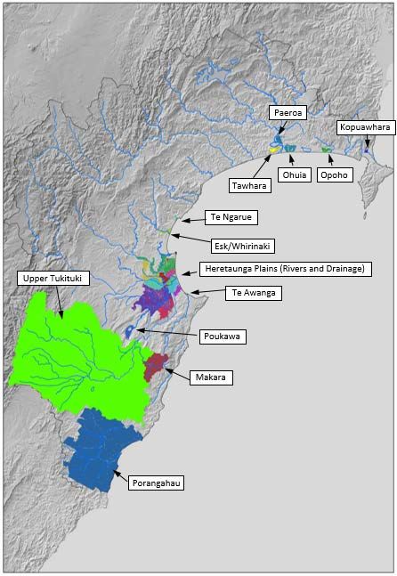
and operating cost for the scheme. HBRC now administers 25 flood control and drainage schemes
throughout the region shown in Figure 2-1 below. It is the assets associated with these Schemes that
form the significant infrastructure managed by HBRC.
Figure 2-1: Our Regions Flood Protection schemes
430 Year Infrastructure Strategy
The largest Scheme is the Heretaunga Plains Flood Control and Drainage Scheme which protects the
cities of Napier and Hastings and highly productive lands in their vicinity.
The schemes have enabled areas benefiting from them to improve the productivity from the land, with
resulting benefits to the economy and resilience of the region. To reflect this wider benefit HBRC sources
the majority of funds to meet the ongoing operation, maintenance and improvement cost of the scheme
from targeted rates levied on properties benefiting from the Schemes, and a minority portion from
general funding sources on a calculated private/public good split basis. General funds are sourced from
general rates levied on all properties across the region and from dividends and interest from HBRC
investments. HBRC believes that the current level of funding for each of the Schemes is adequate to
fund maintenance necessary to maintain Scheme assets such that they continue to deliver the level of
service they were designed to provide, however ongoing Scheme reviews consider both the current
levels of service and increasing demand for potential higher levels of protection, resulting from land
intensification and climate change predictions. A review of any one of the Schemes could result in a
proposal to increase the level of service and maintenance, and or improvement expenditure.
In recent years HBRC has acknowledged the significant potential for the corridors associated with rivers
and streams as habitat and refuge for regional biodiversity, as well as being an integral part of the social
and cultural fabric of the region. Significant work has been done to quantify those values and a number
of projects are now funded through scheme funds to enhance those biodiversity, environmental, cultural,
recreational and social values. Approx 95km of cycleways associated with HB Trails have been
constructed on land and assets associated with HBRC infrastructure. These together with other
recreational uses of river berm land provide significant opportunities for public health and wellbeing.
HBRC is also seeking to reduce, or where possible, eliminate any adverse environmental effects of
activities associated with the operation or maintenance of the Schemes. Recent studies completed
relative to this are The Environmental Code of Practice for River Control and Waterway Works (2017)
and The Hawkes Bay Riverbed Gravel Management Plan (2017), adopted and approved by HBRC in
mid 2017 and Ecological Management and Enhancement Plans developed and operational for the main
river systems.
2.2 Critical Assets
A significant portion of HBRC infrastructure assets is associated with flood control and drainage
schemes that have been established under the Soil Conservation and Rivers Control Act 1941 to provide
benefit to defined areas within the region.
All Schemes have the primary purpose of reducing flood risk and/or the time taken to drain stormwater
runoff from the land following a major rainstorm event. The Schemes also allow increased productivity
from the land by utilising existing small streams along with a network of man-made drains, together with
low level pumps which enable the natural near surface water table to be lowered to a manageable level.
The most significant of these Schemes services the Heretaunga Plains. The Heretaunga Plains Flood
Control and Drainage Scheme includes significant stopbanking and river control works on the three
major rivers (Tutaekuri, Ngaruroro, and Tukituki) crossing the Heretaunga Plains and a network of small
streams, drains and pumping stations under 9 internal catchment drainage areas. The Heretaunga
Plains Flood Control and Drainage Scheme is divided into 10 separate catchments for management and
funding purposes. (Rivers and 9 separate drainage catchment areas).
The Upper Tukituki Flood Control Scheme is the second largest Scheme. This Scheme includes
significant stopbanks and river control works on the Tukituki, Waipawa, and Tukipo Rivers and a number
of their tributaries across the Ruataniwha and Takapau Plains.
The remaining Schemes cover small catchments with minor infrastructure, and are each considered
small compared to the above Schemes.
The integrity of the Heretaunga Plains and Upper Tukituki flood Control Scheme assets are critical to
the Hawke’s Bay economy as they protect a large percentage of the urban Hawke’s Bay population and
significant areas of horticultural and agricultural infrastructure. Stopbanks and associated river control
assets on the three major rivers crossing the Heretaunga Plains are considered critical assets.
5Details of the infrastructure assets are tabled below.
Average
Annual
Physical
Replacement operations and
Asset description dimension/ Level of service summary
value maintenance
number*
budget
(2018-28)
Stopbanks 157km Currently the design Level of
Service (LOS) (1%AEP
River channels and capacity) is provided on the
129km major rivers, however HBRC
edge protection
has committed to increasing the
Drainage channels 447km LOS to convey flood water with
a 0.2% chance of occurrence in
Pumping stations 18 any one year.
Heretaunga Current assessment is that the
Plains Flood River control assets provide
Control and $138,758,848 $4,799,018 100% effectiveness for 1% AEP
Drainage capacity and is at no more than
Scheme a low risk of failure.
Structures and A Level of Service (LOS) review
217
culverts for the drainage network is
underway and scheduled for
completion in the next three
years.
Stopbanks 76km Currently the design LOS
(1%AEP capacity) is provided
River channels and over 95% of the stopbanked
206km reaches.
edge protection
Upper The remaining 5% of reaches
Tukituki Drainage channels 12km $31,637,715 $927,552 remain with reduced
Scheme free board (distance between
design flood level and
Structures and the top of the stopbank).
44
culverts
Stopbanks 15km Current Levels of Service are
being achieved across most the
River channels and 31km smaller schemes. Levels of
edge protection Service vary across the
Small schemes, depending on their
Drainage channels 85km $14,476,397 $805,948
Schemes purpose. Estimated to be
Pumping stations 4 operating at 95% or higher after
allowing for periodic flood
Structures and 37 damage.
culverts
Total replacement value $184,872,960
* as at October 2017
2.3 Current Asset Condition and Reliability
The current approach to determining scheme asset condition and reliability is detailed in each of the
respective Asset Management Plans (Section 8.4 & 8.5 of HPFCS AMP, Section 7.3 & 7.4 of UTTFCS
AMP). Assets are separated into component categories within the asset registers relative to their
function and significance.
A condition matrix is applied to relevant scheme assets that provides a condition scoring, taking account
of criteria such as asset conformance to design specifications, physical condition of the asset, level of
establishment for tree plantings and plant quality, as examples.
630 Year Infrastructure Strategy
Annual audits and inspections of components of the scheme are undertaken by a Professional Engineer
with the production of an annual report, which is used to record overall asset condition and performance
and also to advise any remedial work required as a result of the inspection process.
Critical assets have a current average condition rating score of 4 and 5 for stopbanks, where a score of
1 is very poor condition with defects to 5 which is an asset in excellent condition.
2.4 Other Assets
Pathways
HBRC manages approximately 105 km of pathways which have been constructed on land it owns or
administers. The majority of the pathways form a portion of the NZ Great rides known as HB Trails, and
are constructed along stopbanks and berm areas which are assets of the flood protection schemes.
While HB cycle trails are not significant infrastructure assets, the cost of constructing these has been
met in part by the regional ratepayers and in part by central government through their NZ Cycle Trails
initiative. The replacement value of the pathways is $2,512,514. HBRC therefore has an ongoing
obligation for the management and maintenance of these pathways in accordance with the agreement
HBRC entered into with the then Ministry of Economic Development (22 Nov 2011) which states that
“Under this agreement HBRC is required to brand the Hawke's Bay Trail as forming part of the Nga
Haerenga, New Zealand Cycle Trail, and has agreed to comply with such reasonable conditions as
required by the Ministry, including that the Hawke's Bay Trail be managed and maintained in a
manner that is consistent with the objectives of Nga Haerenga, New Zealand Cycle Trail.”
Regional Parks
HBRC also manages and administers a Regional Park network including:
• Pakowhai Regional Park
• Pekapeka Regional Park
• Waitangi Regional Park
• Tutira Regional Park
• Waipatiki Reserve and contribute towards the management of Te Mata Park.
Prior to 2014, the narrower term Wetlands was used to describe what are now known as Regional Parks.
Within these parks are various recreational facilities, pathways, observation points etc.
It is acknowledged that the pathways and these parks are important community assets. HBRC has
made financial provision in its long term plan for ongoing management and maintenance of these assets,
and for their development and improvement. The replacement value of the regional parks assets is
$2,186,663 (exclusive of land value).
Coastal Assets
HBRC currently has a small number of coastal assets it has constructed and maintains, and at present
funding for these assets is covered by financial provisions within the flood protection schemes. HBRC
began a coastal hazards strategy in 2016 with community representatives and is currently progressing
the detail and outcomes of the strategy through 2017 with the intention for any proposed works to be
considered in the 2018 – 2028 LTP. Further direction for the Coastal Project is dependant on the
outcome of the LTP process and any special consultative processes that may be required with the
community and other Territorial Local Authorities.
The current strategy work, identified as the Clifton to Tangoio Coastal Hazards Strategy 2120, includes
the Hawkes Bay Regional Council, Napier City Council and Hastings District Council as partner
contributing councils. While this area is the focus of the project at this time the project needs to ensure
coastal issues are considered in a regional context and have flexibility to incorporate future potential
coastal issues within the timeline of the 30 year strategy. This will enable areas within Wairoa District
Council and Central Hawkes Bay District Council to be considered as and when issues arise.
Due to the potential significant size, complexity and scale of the Coastal Hazards Strategy, likely
covering all Council areas within the Hawke’s Bay region, it will be structured into its own project
structure for funding, delivery and management, with any assets separately indentified.
73.0 STRATEGIC ISSUES, TRENDS AND RELATED IMPACTS
The task of building, operating and maintaining these infrastructure assets in an affordable manner is
becoming increasingly challenging. This section highlights the projected changes in demographics,
economy, policy, cultural trends and geography that have the potential to impact our management
approach in future. Being aware of the potential for change, will allow us to adapt our approach
accordingly.
The following key strategic issues have been identified;
• Demographic Changes
• Economic Trends
• Natural Hazards
• Legislation and Guidance
• Changes in Community Values
• Iwi Representation
3.1 Demographic Changes
The table and graph below show predicted population changes in the Hawke’s Bay region and each of
the districts that make up the region. The analysis set out below is based on recent updates to the
projections first compiled in 2013, following the national census. These latest figures take into account
the recent influx of skilled migration to our region, a trait which is echoed on a national basis.
The Statistics NZ most optimistic or ‘High’ population growth figure for HB in Year 2043 is 195,900
compared to the Medium or Status Quo figure of 170,710. The Upper Tukituki Scheme is likely to remain
unaffected by any changes in the local population in Central Hawkes Bay, so this position needs to be
considered when the Levels of Service review of the current 1% design standard are carried out.
The potential for population growth on the Heretaunga Plains will be taken into account in the levels of
service reviews for the individual drainage catchment areas programmed to be undertaken over the
coming years.
HBRC manages a number of Schemes in the Wairoa area. It is essential that the Schemes remain
affordable to their benefiting community. As the majority of the Schemes service rural areas, this means
that farming operations must be able to remain profitable and the cost of maintaining Schemes continues
to be exceeded by the value of the benefit provided.
While little population growth is expected to occur within Hawke’s Bay, the average number of people
occupying each house is reducing and is expected to continue to reduce. Drainage catchment areas
servicing urban and peri-urban areas need to accommodate this trend. This will be considered in the
programmed reviews of these areas.
Year Wairoa District Napier City Hastings District CHB District Hawkes Bay
2013 8300 59600 76700 13250 157850
2018 8140 62100 80000 13850 164090
2023 7890 63400 82100 13900 167290
2028 7610 64400 83900 13800 169710
2033 7250 65100 85200 13550 171100
2038 6810 65300 86000 13150 171260
2043 6310 65400 86300 12700 170710
Note: Statistics NZ records for forecast population figures only extend to 2043 from the 2013 census.
The 2018 census will further extend this range.
830 Year Infrastructure Strategy
3.2 Iwi Representation
Iwi relationships form a significant component of Councils responsibilities and obligations. Cultural
significance and awareness are paramount to achieving Councils objectives and policies, with particular
relevance to managing water, protecting the land, environmental enhancement and ensuring protection
for future generations.
Treaty of Waitangi settlements will facilitate increased kaitiakitanga over the rivers and their environs by
Maori and therefore increase HBRC’s involvement with Maori. Cultural values impacted by activities
associated with the ongoing operation, maintenance and improvement of flood control and drainage
Schemes and their environment will be of greater importance. As financial settlements and redress occur
in Hawkes Bay Iwi will be more empowered and better positioned to provide shared input into scheme
management.
HBRC has a Joint Planning Committee with both elected and Tangata Whenua representatives involved
in environmental decision making.
3.3 Economic Trends and Affordability
The most recent figures indicate Hawkes Bay’s regional GDP had an annual growth of 2.8% and it
continues to grow above the national average of 2%. This is driven by a combination of factors, though
most relevant to this strategy are transport, manufacture and agriculture.
Our assets are fundamental to the continuing economic prosperity of our region. In particular, the
Heretaunga Plains Flood Control Scheme (HPFCS) is the economic ‘engine room’ of the Hawke’s Bay
region, accounting for approximately 85% of the regional economy across different indicators. The
catchment comprises the majority part of the Hawke's Bay primary production/processing and related
servicing base. It is an important component of the national fruit and horticultural sector in particular and
forms the main part of the Napier-Hastings urban area which is itself the fifth largest urban centre in
New Zealand.
The HPFCS currently protects a very significant level of residential and business assets, investment and
community infrastructure. Further significant demographic, economic, rural production and other
industry growth is forecast for the catchment area over the longer-term.
9The economic impact losses of three major flooding stop bank breach scenarios were modelled as part
of an ecomomic study which will feed into the Level of Service Reviews. These were breaches at Roys
Hill on the Ngaruroro River, Taradale and Moteo on the Tutaekuri River within the Heretaunga Plains.
The associated direct industry production losses for these areas were $468.3 million, $356.2 million and
$24.4 million respectively. Regional economic impact modelling of these figures indicated resulting total
Hawke’s Bay-wide GDP/Value Added economic impact losses, including direct and flow-on backward
and forward linkage multiplier impacts, of $526.0 million, $317.2 million and $31.7 million respectively.
The Net Present Value/discounted annualised value of these impacts over a 100-year (return flood
event) timeframe is the Roys Hill breach $39.5 million, Taradale breach $23.8 million and Moteo $2.4
million.
These figures highlight the critical part our flood protection assets play for our economy.
3.4 Natural Hazards
Hawkes Bay experiences a number of natural hazards which have the potential to impact our critical
assets. These include;
• Flooding
• Earthquakes
• Tsunami
• Landslides
• Coastal Erosion and Inundation
Severe weather events drive a large number of these hazards and therefore understanding these
hazards, both now and in the future as a result of climate change is vital to managing risk. The levels of
service review currently underway will identify the risk posed to flood protection assets on our rivers
within the HPFCS relative to climate change guidelines published by the Ministry for the Environment.
Floods and the potential impacts these can have under current conditions is well understood by HBRC.
Flood Forecasting and the potential for overtopping of stopbanks can be assessed quickly and our
models are tied into our monoitoring networks which provide real time data to validate our forecasting
models.
Regular risk and condition assessments of our assets also ensure any potential risk of stopbank failure
is understood and maintenance works are performed in a timely manner.
Coastal Communities around New Zealand, and the world, are becoming increasingly aware of coastal
hazards, such as coastal inundation (flooding by the sea), coastal erosion and tsunami.
In Hawke's Bay we have faced these hazards in the past and understand some of the concerns. We
can use this knowledge to look ahead to ensure we are prepared to deal with the challenges of coastal
hazards in the future, creating more resilient communities. All work being considered in the coastal
space will be aligned with the New Zealand Coastal Policy Statement and the need to consider 100 year
time horizons.
Coastal Erosion maps have been compiled and can be accessed online at the HB Coast website. Layers
of probability (likely, possible, very unlikely and highly unlikely) that coastal erosion will affect land in the
present day, at 2065 and at 2120.
Similarly, the extent of coastal inundation (flooding by sea water) possible in a 1% storm event (i.e. there
is 1% chance of a storm of that magnitude happening every year) in the present day, at 2065 and at
2120 has been mapped and is available on the HB Coast website.
The impacts of Tsunami, including maps identifying evacuation zones are also available and HBRC
have developed methods to forecast wave heights relative to different magnitude earthquakes occurring
from both local and distant source. These forecasts, together with those provided by GNS are used by
CDEM to manage disaster risk in our region.
1030 Year Infrastructure Strategy
3.5 Climate Change Context
The Hawkes Bay Regional Council Strategic Plan recognises that provision needs to be made for the
effects of climate change in natural hazard risk assessment. It promotes strategic planning for future
coastal erosion and sea level rise with our Territorial Local Authority partners. Work currently being
undertaken in the Clifton to Tangoio Coastal Hazards Strategy 2120 is considering a range of soft and
hard engineering solutions for the short to medium term, up to 50 years and possible options of managed
retreat or retreat the line options for the long term, 100 years. This adaptive approach is being used in
an attempt to ensure any response options being considered provide the maximum amount of flexibility
and adaptibility to climate change impacts and the significant variability of current predictions. The
community are playing a significant part in developments in this area.
3.6 Legislation and Guidance
Legislation, regulations, new policy and our Regional Resoure Management Plan (RRMP) are significant
part of HBRC’s investement programme. Key regulation include;
• Local Government Act (2002)
• Resource Management Act (1991)
• Soil Conservation and Rivers Control Act (1941)
• National Statement for Freshwater Policy (2014)
• New Zealand Coastal Policy Statement (2010)
• Hawkes Bay RRMP
• Health and Safety at Work Act (2015)
The way land and water resources are managed in the greater Heretaunga and Ahuriri area is under
review. The area encompasses the Tutaekuri, Ahuriri, Ngaruroro and Karamu catchments ('TANK'),
plus the Heretaunga Plains aquifer system. The focus is on water quality, quantity, flows and allocations
in the four catchments, including for wetlands and estuaries.
The whole community across the plains has a stake in the outcome of the TANK project and there are
a number of opportunities for people to have a say in this process – both informally and formally.
This catchment-wide approach to managing water and land will lead to Regional Resource Management
Plan (RRMP) changes that may impact scheme levels of service obligations. Subject to the impact of
any changes, HBRC will need to consider how this is accommodated and managed within the schemes.
3.7 Changes in Community values
The flood control and drainage schemes administered by Council were designed at various times over
the past 50+ years and reflect the knowledge and understanding of that time. These schemes have
modified the natural environment to varying degrees relevant to practices of the time, eg; drainage, tree
clearing, watercourse modifications. The community values and climate impacts with respect to the
natural environment have changed and continue to change at a significant rate. Legislation such as the
Resource Management Act 1991, that requires that any adverse effects of future modifications to the
natural environment are avoided or mitigated are pivotal elements of law driving parts of this change.
More recent impacts, such as climate change and the prediction of more extreme weather events is
influencing community thinking and direction as these experiences are felt in Hawkes Bay.
Public increasingly seek multiple values in addition to the original single purpose of flood protection or
drainage at the time many of the Schemes were established. There are significant opportunities within
scheme areas, particularly where they include river and stream corridors, for these to be enhanced for
aquatic and terrestrial biodiversity, and for public recreation.
The flood control Schemes have substantially reduced the incidence of major flooding in Hawke’s Bay.
As a result many of the Hawke’s Bay public and businesses have little or no knowledge of the potential
impact of a major flood on them and are not well prepared for the consequences should a significant
flood occur.
The National Policy for Fresh water increases the focus on water quality in the region’s rivers. HBRC
leases for grazing the major flood channels of the Heretaunga Plains Flood Control and Drainage
11Scheme and has established fencing where necessary to prevent cattle entering water. Grazing is a
cost effective way of maintaining a short dense grass sward over the berm areas and stopbanks to
reduce the risk of localised scour in a flood event and to minimise fire risk. However there is now an
increasing expectation that stock will be excluded from the vicinity of waterways. The presence of fences
(especially electric) on the river berms is resented by a portion of the community. In the long term there
is likely to be an expectation that significant areas of Scheme land currently grazed are managed
through other approaches. This will result in increased costs as alternative means of maintaining
appropriate vegetative cover on these areas will need to be found.
These issues form part of a current programme of work for HBRC to consider the whole river berm use
for the schemes as part of this LTP round.
Hawke’s Bay rivers, particularly the Ngaruroro, Tukituki and Waipawa are noted as important braided
rivers that provide essential habitat for many endangered bird species and fish including gamefish. As
such, braided rivers are popular with anglers. It is important that the braided nature of the rivers is
allowed to form and not be choked up with unwanted trees such as willow and lupin. Future river
management will most likely require extending the flood protection scheme upstream boundary together
with additional funding to allow for the ongoing removal of unwanted tree species from the braided river
bed. It is essential that the gravel be transported through the river system to the lower reaches and coast
to maintain both channel capacity and the braided channels.
Community consultation and awareness is dealt with in a number of ways, dependent on the size of the
scheme and scale and significance of the issue at hand. Scheme ratepayers are able to engage in the
wider consultation process as part of the development of Long Term Plans and Annual Plans processes,
which typically deal with any new initiatives, review of scheme maintenance costs, inflation
considerations and any minor adjustments proposed for the schemes.
Issues of a more substantial nature, such as major level of service reviews, or significant capital works
are dealt with through targeted meetings such as Liaison Committees where they are established for
the scheme or in focussed ratepayer meetings in the area where the issue has relevance, such as
specific drainage areas in the Heretaunga Plains drainage catchments. Consenting processes, where
they are required for substantial assets, provided another forum for public and ratepayer input and
influence. All members of the public have direct access to Council and scheme managers via websites
or direct contact.
1230 Year Infrastructure Strategy
4.0 SIGNIFICANT INFRASTRUCTURE ISSUES
There are a number of significant infrastructure issues that are expected to be addressed over the life
of this Strategy. These have been identified in the Scheme asset management plans. These issues will
be managed and where possible mitigated as part of scheme levels of service reviews.
A level of service review will include a wide range of actions, such as consideration of;
• National and international advice on climate change predictions;
• Experience and learnings from other schemes nationally;
• Community expectations for appropriate levels of flood protection;
• Community expectations of environmental and ecological standards;
• Appropriate social and cultural involvement and commitment within scheme reviews;
• Affordability and willingness to pay.
There are a number of options available to achieve improved levels of service, particularly where climate
change predictions provide adequate lead time, in some cases decades. This allows time to undertake
a rigorous level of service review and consider longer timeframes for rating implications,
intergenerational funding opportunities and loan funding. For shorter timeframes issues such as
reprioritising and greater innovation around methods and techniques will be required.
The requirement for informing and educating scheme ratepayers to possible impacts and threats to
schemes and scheme assets is a challenging area. Recent experiences within New Zealand, such as
the Canterbury and Kaikoura earthquakes and Edgecumbe floods reinforce the changing climate and
provide a level of tangible evidence and proof that levels of services and past approaches to
management need to adapt and be flexible to a changing environment. This is particularly relevant to
Hawkes Bay.
There is a clearer and greater level of certainty around future impacts on schemes meaning there are a
greater number of challenging issues for Schemes, Scheme Managers, Councils and ratepayers to
confront, with doing nothing becoming less of an acceptable option. With early intervention and
commitment of Councils and Scheme Managers to addressing and educating scheme ratepayers on
predictions and possible alternative solutions, a number of the challenging issues confronting schemes
can be planned, programmed and implemented in an affordable manner.
Refer to Section 5.4 for more specific review detail.
A brief explanation of the most significant of these and options for addressing these are set out below.
Significant
Principal Management Implications of
Infrastructure Description
Options Management Options
Issue
Prediction is for Hawke’s Provision for the impacts The potential impacts of
Bay to be drier but with the of climate change on flood climate change are being
potential for increased flows and sea level rise considered as part of
storminess. Severe will be considered when proposed levels of service
storms are predicted to the levels of service reviews.
bring more intense rainfall provided by schemes are Public consultation will be
Climate which will result in reviewed. part of these reviews. If
change increased flood flows. The impacts of increased preferred option(s) are for
Sea level rise will also drought risk on retention of existing levels
affect assets in the vicinity environmental and river of service, or increased
of the coast. control plantings will be level of service, a capital
considered as an works programme to
operational matter. increase current capacity
13Significant
Principal Management Implications of
Infrastructure Description
Options Management Options
Issue
The implications on of Schemes is expected to
maintaining the status quo be required.
will be increasing
exposure of the schemes Issues such as greater
to more extreme rainfall freeboard allowances for
and flood events and more stopbanks, greater
challenging growing capacity within stopbanks
conditions due to and more resilient plant
extended drier summer species will be considered
conditions. as part of scheme reviews.
Doing nothing will see a
steady decline in levels of
service or a more
intensive response
required for flood events
and damage caused by
more extreme events, as
climate change predictions
take effect.
1430 Year Infrastructure Strategy
Significant
Principal Management Implications of
Infrastructure Description
Options Management Options
Issue
Land use change and There are a number of If the current levels of
climate change are options for improvement to service are to be
predicted to result in current levels of service. maintained or improved,
increased runoff from the These are being explored improvements are
land into the waterways through the level of required to the Scheme
The service currently service review process infrastructure. If no work
provided by the Schemes which will include is undertaken then the
to the Hawke’s Bay public consultation with level of service will decline
includes benefiting communities over time.
• The conveyance of flood and/or land owners. Generally enhanced
water in the major rivers Improvements over time in riverine environment,
safely to the sea up to a environmental, cultural, biodiversity and
flow with a 1% chance of aesthetic values of the recreational opportunities
occurrence in any one environs of waterways are expected to be
year. under schemes on public required in addition to an
• The drainage of flood land as measured by the increased level of
water from the Stream Environmental protection against flood
Heretaunga Plains Valuation (SEV) risk.
without significant methodology.
ponding for rain storm
Levels of events that have a 20%
Service chance of occurrence in
reviews any one year.
• A reduction in the
frequency of flooding in
areas serviced by
smaller schemes
managed by HBRC to
levels defined in their
asset management
plans.
Over the next 15 – 20
years HBRC has
committed (through its
2012/22 LTP) to
increasing the level of
protection provided by the
Heretaunga Plains
Scheme – Rivers
infrastructure to convey
flood water with a 0.2%
chance of occurrence in
any one year.
15Significant
Principal Management Implications of
Infrastructure Description
Options Management Options
Issue
There are a number of Reviews of all of the The potential for increased
potential changes to land Schemes will be runoff through land use
use that can impact on the undertaken over time. change associated with
amount of water running This process will take at urban areas may be
off the land and into least 10 years, however managed to some extent
waterways during heavy reviews of some of the through regulation in
rainfall events. Climate larger schemes are Regional and District
change is predicted to programmed to be Plans. The impacts on
result in increased undertaken within the next runoff through land use
storminess and increased 5 years. change in rural areas will
severity of rainfall events. be considered as part of
A 5% increase in peak the Scheme reviews and
rainfall falling in an event appropriate provision
Land Use with a 1% chance of made in improvement
Change occurrence in any one options that flow from the
year, may result in an reviews.
increase peak flow in a
waterway of up to 25%.
Improvements to urban
stormwater systems,
increased building and/or
urban expansion, changes
in crops grown on the land
– particularly forestry, can
all result in changes to the
speed and quantity of
runoff from the land.
A range of river The gravel management
management practices are review process has
in place to manage this enabled the establishment
risk. These include river of a management regime
Significant quantities of bed beach raking and that will ensure a
sediment are carried by commercial silt and gravel sustainable and resilient
the major rivers. While extraction. gravel (& sediment)
soil conservation initiatives Tree (eg unwanted willows management process.
may reduce the amount of and lupin) removal from
sediment finding its way the braided riverbed within
into rivers over time, New River management will
and outside the current need to extend outside the
Zealand’s geology is scheme areas.
young in geological terms current scheme areas to
Flood channel and erosion will continue A significant gravel protect the braided rivers,
capacity to occur in heavy rain management review and encourage transport
management events for many centuries programme (7 years) was of sediment through the
even with the best soil been completed in 2017 system.
conservation efforts in and provides the basis for
place. The flood carrying managing gravel The implications of this
capacity of waterways will riverbeds. can largely be managed
be compromised by within existing budgets
aggradation of sediment and programmes as the
unless appropriate physical efforts will be
measures are put in place redirected from the areas
to manage that risk. within the schemes, where
flood capacity is at
manageable levels, to
peripheral areas that
would benefit the schemes
1630 Year Infrastructure Strategy
Significant
Principal Management Implications of
Infrastructure Description
Options Management Options
Issue
from more intensive
management.
There are a wide range of Inclusion of a wide range
management options of environmental
available for enhancement initiatives
environmental within scheme budgets will
enhancement. These ensure long term
include riparian retirement improvements to water
and planting, removing quality, development of
stock from waterways and more natural channel
berm areas and fencing, forms and native planting
modifying water courses to resulting in habitat
more natural forms, enhancements.
The majority of the improving water quality by
schemes were developed shading, community and The financial commitment
and constructed in an era Iwi engagement in involved in achieving
when economic growth improvement initiatives. A better ecological outcomes
and development were the number of these initiatives is modest alongside
primary focus of the time. are included in sections of scheme maintenance
Drainage, flood protection a number of the schemes. budgets and typically
and land clearance involves refocusing
enabled farm land and existing budgets to
agricultural initiatives to alternative species
develop and prosper and planting and lessening
Environmental
generate the wealth intensive maintenance
and Ecological
needed to support the activities such as
Management
schemes. Some of this weedboating once shading
&
development has occurred efforts take effect.
Enhancement
at the expense of the
natural environment with
Ratepayer and community
significant impacts on
involvement can offset the
wetlands and rivers and
cost of these initiatives.
the surrounding habitat.
Initiatives are now
included in appropriate Doing nothing is not
areas of the schemes to considered an acceptable
reinstate, enhance or option due to the high
offset environmental and expectation of scheme
ecological opportunities. ratepayers for the
schemes to deal with
water quality and
ecological issues,
particularly in proximity to
urban areas.
This initiative is also
consistent with Councils
refocussed commitment to
improving environmental
and ecological outcomes.
Our coast is eroding and The Clifton to Tangoio If the results of the multi-
Coastal Asset in particular the coastal 2120 Strategy is being criteria analysis being
Management communities from Clifton developed to understand undertaken as part of the
to Tangoio are at most coastal hazards risks and strategy indicate
17Significant
Principal Management Implications of
Infrastructure Description
Options Management Options
Issue
significant risk. With sea the management options intervention is needed in
level rise, the northern and for this key part of the terms of hard engineering
southern coastal Hawke’s Bay coastline. It solutions for safeguarding
settlements will face has begun with the priority our coastline, then major
increasing risk of erosion areas between Clifton and construction works would
and inundation. Tangoio, but will move to commence in the lifetime
focus on other coastal of this strategy.
areas in the future.
The next phase of the
To date the Strategy has project will determine the
identified the areas that cost of the various options,
will be affected by various timing and funding options
coastal hazards over the between the partner
next 100 years to 2120 Councils. This is likely to
and the risks to public and be determined through a
private property, cultural special consultative
sites and areas, process, with costs in the
recreational use and order of $150 – 200m for
infrastructure services. A the 100 year life of the
multi-criteria analysis has strategy.
been carried out with a
pathways approach The cost of doing nothing
determined by the is estimated to run into
community 100’s of millions of dollars.
representatives to best
deal with the future
hazards.
1830 Year Infrastructure Strategy
5.0 MANAGEMENT APPROACH
Our management approach takes into consideration the entirety of an assets lifecycle, from build,
through to operation and maintenance and finally renewals. We tailor our asset management to fit the
needs of our community and local businesses, providing infrastructure to an agreed level of service with
the associated risks being well understood and more importantly well communicated.
The four key areas are the focus for decision making around key infrastructure investment;
• Maintenance of exsiting assets (operation and maintenance)
• Improvements to existing assets (levels of service)
• Replacement of existing assets (renewals)
• Providing new assets to allow for community growth (capital works)
5.1 Maintenance Approach
An annual maintenance programme for all infrastructure assets is prepared prior to the commencement
of each financial year. Maintenance work is largely undertaken by HBRC’s own internal contractor
(HBRC Works Group) under an annual negotiated maintenance contract.
The annual programme of maintenance is designed to ensure that the infrastructure assets continue to
be maintained in accordance with the Scheme asset management plans such that the Scheme
continues to deliver its designed level of service.
Inspections of sections of representative assets are undertaken as part of the annual programme of
works, with all assets inspected over a 5 yearly interval. The annual audit of the Schemes is undertaken
by a Registered Engineer with experience in river and drainage control works and reported to Council.
Cost effective delivery of services
In terms of section 10 (Purpose of local government) there is a clear requirement to meet the current
and future needs of communities for good-quality local infrastructure, local public services, in a way that
is most cost-effective for households and businesses.
(2) In this Act, good-quality, in relation to local infrastructure, local public services, and performance of
regulatory functions, means infrastructure, services, and performance that are—
(a) efficient; and
(b) effective; and
(c) appropriate to present and anticipated future circumstances
The HBRC Works Group operates a fleet of specialist plant and equipment that is specifically designed
to deliver the maintenance contracts efficiently and effectively. In addition the Group undertakes other
less-specialist work utilising local contractors. The Works Group also tenders for work within their area
of expertise from other organisations allowing them to test their competitiveness in the open market.
Any surpluses made by the Works Group on these maintenance contracts are returned to the respective
Scheme at the end of each financial year.
The maintenance activities are defined for each of the respective schemes, with the majority of the
activities defined and established over a considerable period of time. Issues such as seasonal
influences, effectiveness of the maintenance regime and consideration of new techniques and
technologies are considered by Scheme Managers on a regular basis, with programmes modified as
necessary. A typical example of the scheme maintenance regime is tabled below.
19Heretaunga Plains and Upper Tukituki Scheme Maintenance Plan Table
Maintenance Regime
Asset Group
Activity Frequency
Mowing 2-6 times/year
Spraying 20km/year (as required)
Stopbanks Fertiliser 20km/year
Misc. repairs As required
Inspections Rotating monthly
Spraying Annually
Lopping As required
Berms and Buffers Mowing 2-6 times/year
Grazing On-going
Misc. repairs As required
Beach raking Annually
Active Channel
Spraying Annually where required
Survey 3-yearly (gravel extraction reaches)
6-yearly (non-gravel extraction reaches)
Gravel extraction As required, where directed
Inspections Annually (minimum)
Drainage Structures
Misc. repairs As required
Replacement As scheduled (approx. every 50 years)
Groynes Inspections After significant flood events
Annual contractual maintenance expenditure is in the order of;
• HPFCS – Rivers $875,000
• HPFCS – Drainage $1.33m
• UTTFCS – Rivers $625,000
• Small Schemes (Total) $670,000
Figure 5-1 below sets out the predicted ongoing maintenance costs. Section 7.0 of this Strategy sets
out the assumptions under which these estimates have been developed.
Infrastructure Forecast: Operations and Maintenance Expenditure
$12
$10
$8
Millions
$6
$4
$2
$0
Small HPFCS_Drains AREA 9 - PUNINGA HPFCS_Drains AREA 8 - TUTAEKURI-WAIMATE/MOTEO
HPFCS_Drains AREA 7 - RAUPARE/TWYFORD HPFCS_Drains AREA 6 - KARAMU & TRIBUTARIES HPFCS_Drains AREA 5 - HAUMOANA
HPFCS_Drains AREA 4 - MUDDY CREEK HPFCS_Drains AREA 3 - PAKOWHAI HPFCS_Drains AREA 2 - BROOKFIELDS/AWATOTO
HPFCS_Drains AREA 1 - NAPIER/MEEANEE/PUKETAPU HPFCS_Rivers UTTFCS
Figure 5-1: Projected Operational Expenditure – Infrastructure Assets
2030 Year Infrastructure Strategy
5.2 Scheme funding
A separate operating account is held for each specific scheme. All Scheme funds (targeted rates,
general funding allocated to the Scheme, other Scheme income and interest on accumulated funds) are
credited to the operating account. Scheme costs (operating, maintenance, and improvement costs, rate
collection costs, depreciation, and interest on Scheme deficits) are debited from the account. Any
balance remaining in the account (credit or debit) is carried forward from one financial year to the next
as a reserve balance.
The major beneficiaries of the Schemes are the owners of land within the scheme areas that are able
to use their land more productively. These beneficiaries pay the majority of the cost of operating and
improving each scheme through a rating classification approach using targeted rates. However HBRC
recognises that there are wider benefits to the region from land being used more productively, continued
access to major urban areas and critical infrastructure and accordingly a portion of the Scheme costs
are funded from HBRC’s general funding sources, i.e. general rates and interest and dividends from
HBRC investments.
The table below sets out the funding sources for each Scheme.
Economic assessments of the wider benefit to the Hawke’s Bay Region have assisted HBRC in
establishing the proportion of direct benefit vs region wide benefit for the major schemes.
This work showed that the Heretaunga Plains Flood Control and Drainage Scheme – Rivers provided
an environment within which significantly increased economic activity was able to occur across the
whole region resulting in increased population and facilities to support that population. Accordingly 30%
of the cost of the Scheme is met by HBRC general funding.
The Schemes covering the individual catchment areas on the Heretaunga Plains have resulted in
improved productivity from the land which is assessed as justifying 10% of the cost of those Schemes
being met from general funding sources.
Similarly the Upper Tukituki Scheme provides approximately half the benefit attributable to the
Heretaunga Plains Flood Control and Drainage Scheme – Rivers to the whole region, but the cost of
maintaining this Scheme is exacerbated by gravel flowing from the Ruahine Ranges. This is deemed
to warrant an additional 2.5% of general funding input.
The principles used for the small schemes are as follows.
• Schemes that provide protection to a State Highway receive 12.5% general funding contribution
• Schemes that provide protection to local roading networks receive 10% general funding
contribution
• Other Schemes receive 5% general funding contribution.
21Targeted General
rate funding
Scheme portion portion
(Private) (Public)
Heretaunga Plains Flood Control and Drainage Scheme
• Rivers 70% 30%
Drainage catchment Schemes
• Napier/ Meeanee
90% 10%
• Awatoto/ Brookfields
90% 10%
• Pakowhai
90% 10%
• Muddy Creek 90% 10%
• Haumoana 90% 10%
• Karamu and tributaries 90% 10%
• Raupare/ Twyford 90% 10%
• Tutaekuri -Waimate 90% 10%
• Puninga 90% 10%
Upper Tukituki Scheme 82.5% 17.5%
Small Schemes
• Upper Makara 90% 10%
• Paeroa 87.5% 12.5%
• Porangahau 90% 10%
• Poukawa 95% 5%
• Ohuia – Whakaki 95% 5%
• Esk 87.5% 12.5%
• Whirinaki 87.5% 12.5%
• Te Awanga 90% 10%
• Te Ngarue 90% 10%
• Kopuawhara 90% 10%
• Kairakau 90% 10%
• Opoho 90% 10%
• Wairoa Rivers and Streams 87.5% 12.5%
• Central and Southern Area Rivers & Streams 87.5% 12.5%
The Hawkes Bay Regional Council established public/private good benefit allocations for the various
schemes many years ago. A variety of rationale was used to initially establish the splits such as
economic performance, population areas and access to urban areas and State highways and roading
networks. These have generally been reviewed as part of LTP deliberations or as part of significant
scheme reviews, such as Level of Service reviews. The most recent review was completed by Sean
Bevin of Economic Solutions Ltd in October 2010.
Information from that review indicated that private benefit proportions for other New Zealand schemes
similar to those in Hawkes Bay ranged from 50 – 100%, with an average benefit proportion of around
80%. While every scheme has their own peculiarities and nuances the report concluded that the
approach of using capital valuation for the rating basis, along with specific rationale applied to each
respective scheme to develop the above public/private good rating splits was a reasonable balance of
all these parameters within the Hawkes Bay Schemes.
5.3 Renewal approach
The effective life of each asset (and in some cases components of an asset) have been identified,
assessed and recorded as part of the HBRC Infrastructure Asset Database. Some examples are set
out in the table below
22You can also read