Caltrans TMC Coordination
←
→
Page content transcription
If your browser does not render page correctly, please read the page content below

Caltrans TMC Coordination

            The William and Barbara Leonard
            University Transportation Center

       California State University San Bernardino

  Prime Award No. 65A0244, Subaward No. GT 70771
Awarding Agency: California Department of Transportation

                  Jeff Gerfen, B.S, M.S.
                      Neil Hockaday

 California Polytechnic State University, San Luis Obispo
            Advanced Technology Laboratories
                San Luis Obispo, CA 93407

                    September 2009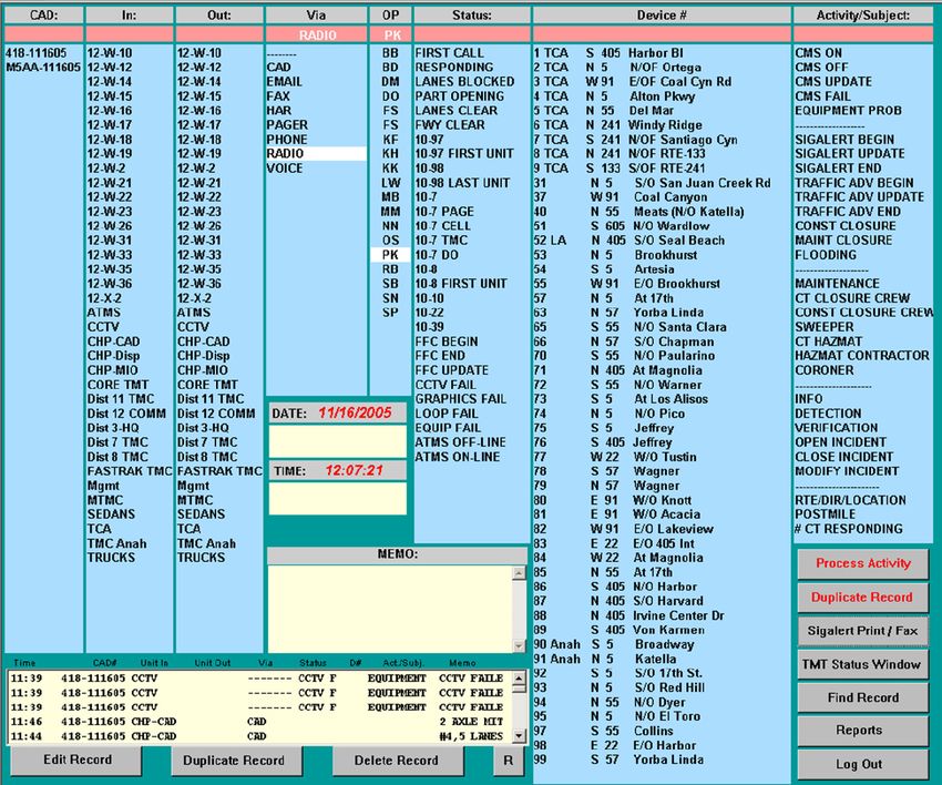
DISCLAIMER
This project was funded in its entirety under contract to the California Department of
Transportation.

The contents of this report reflect the views of the authors, who are responsible for the facts
and the accuracy of the information presented herein. This document is disseminated under
the sponsorship of the U.S. Department of Transportation, The William and Barbara Leonard
University Transportation Center (UTC), California State University San Bernardino, and
California Department of Transportation in the interest of information exchange. The U.S.
Government and California Department of Transportation assume no liability for the contents
or use thereof. The contents do not necessarily reflect the official views or policies of the State
of California or the Department of Transportation. This report does not constitute a standard,
specification, or regulation.

                                                 i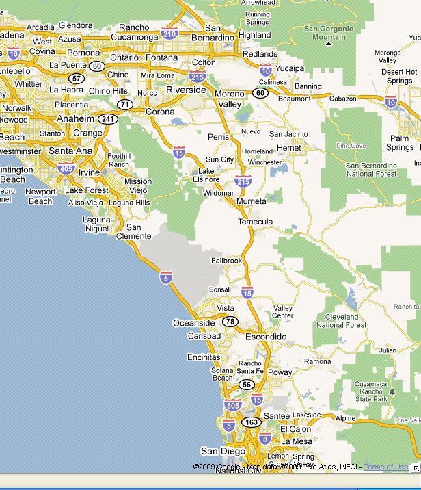
ACKNOWLEDGMENTS
The authors wish to acknowledge and thank the agencies and associated TMC management
staff that have provided information and / or contributed to this report:

    − Mike Jenkinson, Caltrans Headquarters, TMC Operations

    − Markus Heiman, Caltrans District 3 TMC

    − Ramin Bolourchian, Caltrans District 4 TMC

    − Jacques Van Zeventer, Caltrans District 5 TMC

    − Sergio Venegas, Caltrans District 6 TMC

    − David Lau, Caltrans District 7 TMC

    − Alan Kirst, Caltrans District 8 TMC

    − Lima Kopitch, Caltrans District 11 TMC

    − Paul King, Caltrans District 12 TMC

                                                ii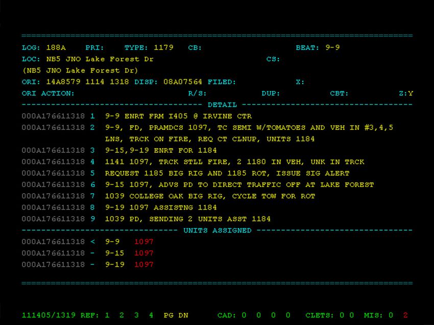
ABSTRACT
Caltrans Transportation Management Centers (TMCs) are tasked with the management of the
statewide transportation system to reduce congestion and provide for the safe movement of
people, goods, and information. They must work with neighboring TMCs to ensure the
continued efficient operation of that system, and coordinate to manage larger‐scale incidents
and regional emergencies. This report focuses on coordination in metropolitan areas of
California and summarizes the methods utilized for coordination statewide through interviews
with operations managers from eight Caltrans TMCs. It identifies the major tools utilized in
TMC traffic management, specific examples of TMC coordination, and potential areas for
improvement in coordination including methods of sharing collected data between districts.

                                              iii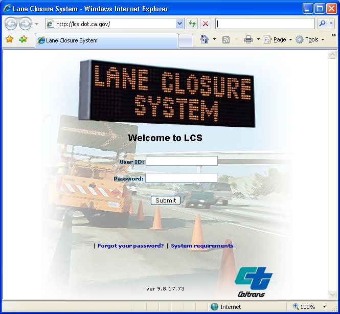
EXECUTIVE SUMMARY
The first Traffic Management Center in California was constructed in 1971 in Los Angeles,
providing management of the Santa Monica, San Diego, and Harbor freeways. TMCs today
operate under a mandate to aggressively manage the statewide transportation system to
reduce congestion and provide for the safe and efficient movement of people, goods, and
information. They must respond to unique and dynamic traffic conditions and incidents, which
can arise without warning, change rapidly and unpredictably, and create both congestion and
potentially dangerous conditions for travelers.

California is divided into 12 Caltrans districts, covering a wide geographical area and having
varied traffic management and coordination requirements. These districts are comprised of
more than 50,000 miles of highway and freeway lanes, supporting in excess of 150 billion
vehicle miles traveled per year. Caltrans TMCs use a variety of tools to manage this traffic, with
significant traffic management tool commonality between districts. The telephone is the
primary means of coordination between Caltrans TMCs. CHP Computer Aided Dispatch (CHP
CAD) and maintenance radios are also sometimes utilized to assist in coordination. Changeable
message signs are commonly used to organize coordinated traffic diversions. Surveillance video
and field equipment are sometimes also shared during the process of coordination.
Additionally, some inter‐district coordination occurs through statewide TMC manager meetings
and the development of standard operating procedures to aid in coordinating a well thought
out response to predictable, yet significant traffic disturbances.

Effective coordination between four Caltrans districts was demonstrated during a large oil
tanker fire in Southern California in 2002. The telephone was used to create CMS‐based
diversions, which were central to the management of the incident. This incident affected traffic
over a wide geographical area. Southern California TMCs have also demonstrated effective
coordination for closures of Interstate 5 on the Grapevine during winter storms; well thought
out standard operating standard operating procedures help TMC operators and Caltrans
personnel in the field respond methodically and properly to the predictable closures of this
stretch of freeway, minimizing delays and dangerous conditions for motorists. Other incidents
in Central California illustrated the need for better preparation and more eyes in the field.
California TMC training has been modified to help TMCs be better prepared to manage large
incidents.

Traffic management capabilities can be leveraged through coordination. Quick and reliable
inter‐district communications, even if it is simply a telephone conversation, can assist in
reducing the effects of an incident in one district on conditions in a neighboring district through
the use of CMSs to reduce or mitigate the effects of upstream traffic upon an incident. The
concept of interoperable equipment should be fully explored to determine feasibility. Data and
video sharing between jurisdictions, regardless of government level, e.g. city, county, or state,
should be seamlessly integrated into future ATMS implementations.

                                                 iv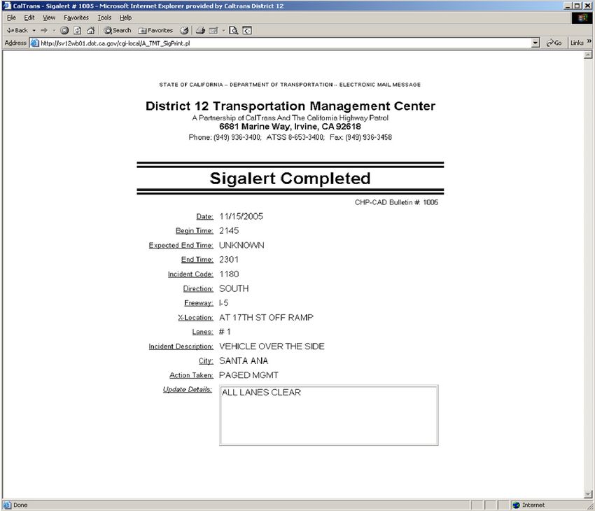
Inter‐district collaboration and preparation develops the skills and capabilities required to
effectively handle large incidents. The development of standard operating procedures provide
an excellent opportunity to both explore methods of handling incidents and for district
personnel to establish working relationships which can be called upon during the handling of
major incidents. CHP CAD is an unsung hero of traffic management due to its reliability and
consistency of use throughout the state. CHP CAD demonstrates many attributes which are
desirable in traffic management systems; it is trusted, comprehensive, timely, and ubiquitous
within California. The design of future transportation management tools should consider these
key characteristics of CHP CAD which have contributed to its success.

                                              v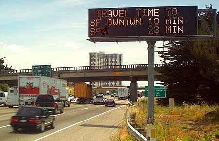
COMMONLY USED TERMS AND ACRONYMS
ATMS       Advanced Traffic Management System

Caltrans   California Department of Transportation

CCTV       Closed‐circuit television. Used by TMC operators to monitor traffic flow, and
           respond to incidents.

CHIN       Caltrans Highway Information Network. A system to provide the public with
           current highway condition information.

CHP CAD    California Highway Patrol Computer‐Aided Dispatch.

CMS        Changeable Message Sign. An electronic traffic sign used to convey travel
           advisories and other information or warnings to motorists.

D[x]       Caltrans District number (e.g. D5). Highway operation and maintenance
           responsibilities throughout California are broken up into districts. A district map
           included in this document, and can also be found online at
           http://www.dot.ca.gov/districtmap.htm.

DHS        Department of Homeland Security

EOC        Emergency Operation Center. Central command and control facility to perform
           strategic level management in the event of an emergency situation.

FHWA       Federal Highway Administration

HAR        Highway Advisory Radio. Low‐powered radio stations that provide traffic hazard
           and travel advisory information.

ICS        Incident Command System. A system utilized by CHP to manage incidents.

MAIT       Multidisciplinary Accident Investigation Team or Major Accident Investigation
           Team. Responsible for intensive incident investigations in order to determine all
           of the causative factors leading up to the collision and any injuries or fatalities.

MPO        Metropolitan Planning Organization. Policy‐making organization comprised of
           representatives from local government and transportation authorities.

NIMS       National Incident Command System. Consists a set of principles, doctrines, and
           terminology to provide a systematic and proactive approach to preventing,
           responding to, and mitigating the effects of incidents.

                                             vi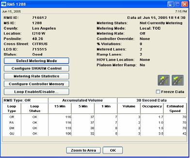
PeMS    Freeway Performance Measurement System. Collects real‐time and historical
        freeway data to compute freeway performance measures.

SOP     Standard Operating Procedure

TMC     Transportation Management Center

TMCAD   Traffic Management Center Activity Database

TMCAL   Traffic Management Center Activity Log

TMT     Traffic Management Team

                                       vii
TABLE OF CONTENTS
Disclaimer i
Acknowledgments ii
Abstract iii
Executive Summary iv
Commonly Used Terms and Acronyms vi
1. Introduction 1
2. Caltrans Traffic Management 2
2.1 Caltrans Districts 2
2.2 California Traffic Management Tools 3
2.2.1 Advanced Transportation Management System (ATMS) 3
2.2.2 Video Surveillance 4
2.2.3 California Highway Patrol Computer‐Aided Dispatch (CHP CAD) 5
2.2.4 Incident Logging 6
2.2.5 TMCAL 8
2.2.6 Ramp Meter Control 9
2.2.7 Changeable Message Signs and Highway Advisory Radio 10
2.2.8 Lane Closure System (LCS) 10
2.2.9 Freeway Performance Management System (PeMS) 11
3. Existing TMC Coordination in California 13
3.1 Coordination Methods 13
3.1.1 Telephone 13
3.1.2 CHP CAD 14
3.1.3 Changeable Message Signs & Coordinated Diversions 16
3.1.4 Shared Surveillance Video 16
3.1.5 Field Units and Equipment 16
3.1.6 Inter‐District TMC Management Meetings 17
3.1.7 Standard Operating Procedure (SOP) 17
3.1.8 Freeway Performance Management System (PeMS) 17
3.1.9 Regional ITS Element Integration 18
3.2 TMC Coordination Examples 19
3.2.1 Tanker Fire on Interstate 5 in Southern California 19
3.2.2 Operation Snowflake – Closure of Interstate 5 North of Los Angeles 20
3.2.3 Lane Closures on Highway 17 South of San Francisco 23
3.2.4 Closure of Interstate 5 in Central California with Diversions to Local Arterials 24
viii4. Discussion, Conclusions, and Recommendations 26
4.1 Coordination Fundamentals 26
4.1.1 Leverage Local Traffic Management Capabilities with Coordination 26
4.1.2 Share Video Comprehensively to Support Public and Private Use 26
4.1.3 Different Districts Use Different Methods 27
4.1.4 Telephone and Incident Logging 28
4.1.5 Deploy New Systems to Retain Existing Capabilities 28
4.2 Prepare to Manage Traffic 28
4.2.1 Inter‐District Collaboration and Preparation Develops Coordination Muscle 28
4.2.2 Standard Operating Procedures – Thought Provoking and Extremely Useful 29
4.2.3 Ensure Coordination Ability by Covering the Basics 29
4.3 CHP CAD Achievements & Lessons 30
4.3.1 Trusted, Comprehensive, Timely, and Ubiquitous 30
4.3.2 A Traffic Management Success Story and a Role Model for Future Systems 30
4.3.3 Lessons in Sharing Data Across Jurisdictional Boundaries 31
References 32
ixTABLE OF FIGURES
Figure 1: California Department of Transportation District Map................................................... 2
Figure 2: Delcan Advanced Traffic Management System ............................................................... 4
Figure 3: CHP Computer‐Aided Dispatch ....................................................................................... 5
Figure 4: District 12 Activity Log and Sigalert notification ............................................................. 7
Figure 5: Delcan System Wide Adaptive Ramp Metering system .................................................. 9
Figure 6: Changeable message sign displaying estimated travel times ....................................... 10
Figure 7: Caltrans Lane Closure System ....................................................................................... 11
Figure 8: Freeway Performance Measurement System web site ................................................ 12
Figure 9: Telephone Coordination................................................................................................ 13
Figure 10: CHP Division and Caltrans District overlap in Southern California ............................. 14
Figure 11: D8 and D11 I‐15 / I‐215 Corridor with Caltrans District & CHP Division boundaries . 15
Figure 12: Tanker fire on Interstate 5 in Southern California near Oceanside............................. 19
Figure 13: District 12 CMS diversion message deployment for Interstate 5 South closure ........ 20
Figure 14: Interstate 5 with snow closure area and diversion routes shown .............................. 21
Figure 15: Operation Snowflake operational phases and planned diversions ............................ 22
Figure 16: Hwy. 17 maintenance area with approximate Caltrans district boundaries shown ... 23
Figure 17: Typical inter‐district information path between maintenance personnel .................. 25
x1. INTRODUCTION The National Interstate and Defense Highways Act, or Federal‐Aid Highway Act of 1956 initiated one of the largest public works projects in American history – to construct approximately 41,000 miles of interstate highway. While a primary goal of this effort was one of national defense, a direct result was the subsidy of roadway infrastructure that permitted easy travel of both personal and commercial traffic between urban centers, contributing to the suburbanization of the nation. By the early 1990’s, the focus on managing highway congestion, both nationally and within the state of California, was shifting from that of continued highway build‐out to an approach of improving the efficiency of existing roadways. The first major direction at the federal level came in the form of the Intermodal Surface Transportation Efficiency Act of 1991 (ISTEA) which pushed an intermodal approach to highway funding, promoting the intelligent management of infrastructure. ISTEA spawned the concept of Intelligent Vehicle Highway Systems (IVHS), which grew into Intelligent Transportation Systems (ITS), which is defined as “the application of computers, communications, and sensor technology to surface transportation”. The first Traffic Management Center in California was constructed in 1971 in Los Angeles, providing management of the Santa Monica, San Diego, and Harbor freeways through the use of technologies such as loop detectors and ramp metering. Today, TMCs have become an accepted tool for managing traffic incidents and congestion at the state and local levels, both within and outside of California. They must respond to unique and dynamic traffic conditions and incidents, which can arise without warning, change rapidly and unpredictably, and create both congestion and potentially dangerous conditions for travelers. This report provides an overview of TMC coordination within the state of California and is based on interviews with TMC managers from the Southern, Central, and Northern regions. Due to the modest nature of this project not all TMC managers were interviewed, rather a subset from major urban areas of California were queried for information to paint a representative picture of the whole. As such, this report will focus on traffic coordination in metropolitan areas of California. Although this report focuses on TMC coordination, the general concepts related to traffic and incident management tools and techniques utilized in California are explored, as their use is directly applicable to coordination of traffic management, both at a state‐to‐state and a state‐to‐local level.
2. CALTRANS TRAFFIC MANAGEMENT

2.1 Caltrans Districts
California is divided into 12 Caltrans districts, covering a wide geographical area and having
varied traffic management and coordination requirements. These districts include both major
metropolitan and rural areas. Figure 1 below shows the different Caltrans districts within
California. Major metropolitan areas in California include the San Francisco Bay Area, Los
Angeles, the Inland Empire, San Diego, and the Stockton/Sacramento area. Caltrans manages
more than 50,000 miles of highway and freeway lanes across these districts, in both rural and
metropolitan areas, supporting in excess of 150 billion vehicle miles traveled per year.

Figure 1: California Department of Transportation District Map

                                               2
2.2 California Traffic Management Tools
The mission of a Caltrans TMC is to “efficiently manage the region’s transportation system to
reduce congestion and provide the safe and efficient movement of people, goods, services, and
information”. Key TMC tools, which are used to support both normal TMC and coordinated
TMC operations, are discussed in the following sections.
2.2.1 Advanced Transportation Management System (ATMS)
The Advanced Transportation Management System provides a high level management interface
to real‐time data sources to monitor highway traffic flow. With it, operators are able to utilize
technologies such as vehicle detector stations (VDS), ramp‐metering stations (RMS), closed‐
circuit television cameras (CCTV), and changeable message signs (CMS) to improve highway
safety, swiftly react to highway and regional incidents, and reduce congestion. Examples of
vehicle detector stations include in‐roadway inductive loops, camera‐based video detectors, and
microwave wireless stations. These stations provide vehicle counts, speed information, and
lane occupancy.
The most commonly used ATMS system in California is the Delcan ATMS, currently installed in
the Southern California and Inland Empire districts (D7, D8, D11, and D12) and installed or being
implemented in northern California (D3, D4). Roadway speed information is readily viewable on
the ATMS display as green, yellow, or red icons depicting flow conditions. Operators can click on
these icons to learn more information about a particular segment of roadway. If an incident
occurs it is often visible as a series of red icons on the roadway where traffic has begun to
significantly slow or stop. Operators can quickly assess the situation using integrated CCTV
access and respond appropriately. The public can be advised using integrated CMS messaging
tools within the ATMS.
While the Delcan ATMS is the dominant traffic management system in California, it is not
without its flaws. Despite similar architectures, ATMS software installations in each Caltrans
district require extensive customization, configuration, and modification efforts to function
within the installation device network. This results in a highly specialized installed system that
cannot easily be linked to display data from outside of the host district nor readily permit
replication for transplant installation in another district. There is desire within the Caltrans
ranks for a next‐generation ATMS implementation that would allow easy extension and
modification in a non‐proprietary implementation, but as of this writing no significant progress
has been made towards this approach.
3Figure 2: Delcan Advanced Traffic Management System
2.2.2 Video Surveillance
Closed‐circuit television systems have been a consistent mainstay of traffic management. While
it is not a new technology, in terms of usage CCTV is an extremely useful tool available to TMC
operators. The capability to view real‐time or near real‐time roadway traffic conditions gives
operators the ability to analyze traffic and assist in providing effective incident and emergency
response through visual assessment of an incident scene. Innovative methods of CCTV
implementation have emerged in recent years, enabling the installation of cameras in locations
where it previously would have been too costly or otherwise technically impractical. At the time
of this writing, Caltrans has approximately 1,300 cameras monitoring freeways, highways, and
related infrastructure in the state of California. Some of these cameras have pan, tilt, and zoom
capabilities allowing the operator to better focus on objects within range of the device, and gain
a better understanding of unfolding events.
In many districts video feeds are also made available for use outside of the TMC. Of these feeds,
only a subset are typically made available to the public and to the media via the Internet. More
than half of Caltrans districts have their own individual Web pages that list cameras available for
viewing on their district web site. Caltrans also maintains a consolidated set of links to public
video feeds at http://video.dot.ca.gov. Additional non‐public video feeds are available to TMC
personnel via the Caltrans intranet.
4While these public video feeds provide a valuable service to many interested parties such as
news aggregators, media outlets, and the motoring public, Caltrans must balance the desire for
openness with the concern for privacy. Organizations such as the ACLU have voiced civil‐liberty
concerns regarding the increasing use of CCTV cameras on highways, and the potential for their
use in law‐enforcement roles. To alleviate such concerns, Caltrans does not routinely record or
archive video data as part of normal operations. Additionally, cameras are only used in law‐
enforcement roles when installed in toll‐based locations such as bridges for the ticketing of non‐
paying vehicles. Districts also have the ability to disable any or all of their public video feeds to
prevent the viewing of sensitive or disturbing imagery by the public on an as‐needed basis.
2.2.3 California Highway Patrol Computer‐Aided Dispatch (CHP CAD)
The CHP CAD is a secure system used by the CHP to support dispatch and response functions. It
links all dispatcher workstations, provides reliable and accurate incident information, and both
standardizes operational procedures and decreases incident response times through elimination
previously used manual processes. Although not a Caltrans system nor originally intended for
Caltrans use, CHP CAD is today one of the primary methods for the dissemination of incident
information within TMCs. TMC operators in many districts now rely on this system as it is often
the point of first notification for an incident, and provides regular updates as the situation
progresses.
Figure 3: CHP Computer‐Aided Dispatch
5The CHP CAD is now considered a legacy system due to its specialized dedicated hardware
requirements, and a project is currently underway to develop its replacement.
2.2.4 Incident Logging
The Federal Highway Administration (FHWA) defines a traffic incident as “any non‐recurring
event that causes a reduction of roadway capacity or an abnormal increase in demand” or “an
emergency road user occurrence, a natural disaster, or other nonrecurring or unplanned event
that affects or impedes the normal flow of traffic”. Traffic Management Centers handle a
significant number of traffic incidents daily, up to several hundred per day in urban areas.
Maintaining a record of the management of incidents facilitates the handling and clearing of
incidents and provides a record of activities undertaken. Such a record can be crucial in
providing accurate incident reporting both during an incident for the purposes of intra and
inter‐agency notifications, and for after‐action analysis and accounting to both state and federal
agencies.
While standardization is desired, currently no statewide standard system exists in California for
the provision of incident logging. As a result many districts have created their own
implementation for recording incident management activities. For example, District 12 in
Orange County, has implemented an Internet browser‐based system that easily enables
operators to create new incident logs and update them as needed with simple click‐lists that
walk them through adding an entry. Incident and notification reports such as Sigalerts are easily
generated from within this interface.
Another incident logging system utilized by Caltrans is TMCAD, developed and implemented by
the District 6 TMC in Fresno. TMCAD is a Microsoft Windows‐based application that provides
linkages for the management of field devices, and can provide ready access to contact
information and standard operating procedures. Two other districts (D5 and D10) are currently
also using the Fresno TMCAD logging system.
6Figure 4: District 12 Activity Log and Sigalert notification
72.2.5 TMCAL
Due to the lack of a standardized statewide logging system, Caltrans is currently investigating
options for developing such a system. The designation for this new logging system is the Traffic
Management Center Activity Log, or TMCAL. TMCAL will incorporate many of the features
found in the custom logging systems installed throughout the state, and provide a centralized
source of incident information with a uniform interface and standardized operation for use
throughout California.
In addition to the provision of centralized logging, it is envisioned that TMCAL will provide post
incident reports and performance measurement and reporting for Traffic Management Center
operations, and simplify data archiving and retrieval. It will include linkages to the Satellite
Operation Center Command System (SOCCS) and Advance Transportation Management System
(ATMS) in each district, as well as updates to the California Integrated Information Network
(Calnet II). In addition, the creation of a standardized statewide system would provide for
automatic notification of incidents and closures to both the California 511 webpage servers and
to the Caltrans Headquarters Communication Center, which operates the California Highway
Information Network (CHIN) and provides the department’s notification and reporting of
incidents to the Governor’s office.
A core requirement of TMCAL is the provision of a centralized interface to the CHP’s Computer
Added Dispatch (CAD) System. As the CHP moves towards implementation of their next‐
generation computer‐aided dispatch system, the capability for direct communication between
the two systems to synchronize incident logging is a high priority. Such a communications
capability will enable both Caltrans and CHP to be aware of the activities undertaken by each
other and eliminate redundant log entries on either side. The integration of TMCAL as the
primary information bridge between the two organizations would also likely result in the
elimination of direct CHP CAD terminal access for TMC personnel, thus eliminating a long‐time
security issue for both CHP and Caltrans alike due to the U.S. Department of Justice security
clearance certifications required to use and view CHP CAD.
The stated objectives for the TMCAL project as defined by Caltrans are:
− Reduce twelve (12) independent systems to one statewide system to perform
incident response logging.
− Improve capture, archive and reporting of incident data and activities performed by
TMC operations.
− Generate performance measurement reports.
− Provide an interface to the CHP CAD system.
− Increase the efficiency and timely reporting of the Calnet II data.
− Replace the existing process of notification by telephone and fax between TMCs and
the executive branch; to a single data file provided through a statewide system of
8information used for the Department’s Executive Notification and reporting of
incidents.
− Replace the existing system using telephones for coordination between TMCs with a
centralized database.
2.2.6 Ramp Meter Control
Freeway on‐ramp metering is one of the primary dynamic methods available to Caltrans to aid
in maintaining efficient travel on the highway system. By managing the rate at which vehicles
enter the freeway system, overall travel and highway speed is maintained and provides greater
efficiency over the length of a corridor. Safety is also improved as the numbers of incidents are
reduced in the area of the metered onramp. Ramp‐metering is a relatively inexpensive tool
which provides visible improvement in traffic flow. Caltrans is committed to ramp‐metering
systems, and considers them an integral part of their Traffic Operations Program Strategic Plan.
While much of the control for these systems are automated and run at scheduled times of peak
traffic flow, some districts utilize dynamic ramp metering systems. Dynamic metering systems
adjust metering rates based on real‐time traffic flow data from Caltrans vehicle detection
stations. For example, District 7 in Los Angeles implemented a Delcan System Wide Adaptive
Ramp Metering (SWARM) system, which in addition to providing TMC operators with a
centralized platform for control of the ramp‐metering is also capable of forecasting traffic
conditions, and adapting metering rates system‐wide to compensate for anticipated traffic flow
issues.
Figure 5: Delcan System Wide Adaptive Ramp Metering system
92.2.7 Changeable Message Signs and Highway Advisory Radio
Changeable Message Signs and Highway Advisory Radio are two of the primary tools utilized by
TMC operators to advise and inform the motoring public to traffic advisories, delays, and
emergency conditions. For districts with ATMS installations, CMS control is typically performed
through the ATMS application, allowing the operator to use a map‐based display to view which
signs have been activated within their district and what messages are displayed. Additionally,
automated CMS systems are utilized on various routes in both northern and southern California
to provide estimated travel times to commuters.
Highway Advisory Radio systems broadcast a prerecorded loop of information on a low‐power
radio stations. These radio bulletins are usually announced via activation of CMSs to notify
motorists to tune to the broadcast. While some districts HAR installations still require voiceover
of the recorded message to be broadcast by a practiced TMC operator, these systems have
largely been replaced in favor of text‐to‐speech voice synthesis systems. Text‐to‐speech voice
systems provide message uniformity throughout the HAR network and permit the ready‐
activation of pre‐formed messages that are vetted against both Caltrans district and
Headquarters communications policies.
Figure 6: Changeable message sign displaying estimated travel times
2.2.8 Lane Closure System (LCS)
The Lane Closure System (LCS) provides reporting capabilities which allow traffic managers to
track lane, ramp, and road closures due to incidents, construction, and maintenance. Caltrans
currently maintains a statewide LCS that tracks active closures as well as all planned closures for
10the next seven days from any given day. District TMCs can utilize this information to monitor
both their own closures as well as those planned on highways in adjacent districts, and also
coordinate closures with their neighbors. This system is utilized by all districts save District 7 in
Los Angeles, which employs its own implementation and provides notification of planned
closures via its Web site.
Figure 7: Caltrans Lane Closure System
2.2.9 Freeway Performance Management System (PeMS)
The Freeway Performance Measurement System is a cooperative project between Caltrans and
the U.C. Berkeley Partners for Advanced Transit and Highways (PATH) to collect real‐time
highway data and provide both live and historical perspectives on freeway performance. While
PeMS is more actively utilized in some districts than others, it is one of the only means of inter‐
district traffic data sharing. Real time roadway information and charting is available to the
public via the PeMS web site (https://pems.eecs.berkeley.edu), and historical data is accessible
via login.
11Figure 8: Freeway Performance Measurement System web site
123. EXISTING TMC COORDINATION IN CALIFORNIA
Coordination between Caltrans TMCs in California is extremely varied, ranging from electronic
sharing of data for control of ramp metering rates in some districts to using the telephone to
coordinate activities in others. This section first provides an overview of tools which are used to
support TMC coordination and then provides examples of TMC coordination in California.
3.1 Coordination Methods
3.1.1 Telephone
The telephone is the cornerstone of TMC coordination; TMCs routinely call each other to work
out how to handle non‐recurring congestion which is crossing district boundaries. Every district
interviewed utilizes the telephone for coordination with entities outside their boundaries. For
example, Caltrans District 7 (Los Angeles and Ventura Counties) indicated that TMC‐to‐TMC lines
of communication are always open and that one district can always call another to solve a
problem. District 7 also indicated that they coordinate via telephone with local cities regarding
signal timing on arterials.
Figure 9: Telephone Coordination
Although it might seem obvious that telephone is central to inter‐district communications, its
importance should not be understated due to its prevalent use – the telephone provides a
critical link between Caltrans TMCs.
133.1.2 CHP CAD
CHP CAD is a workhorse of traffic management and is often used to support coordination
between districts. CHP Divisions and Caltrans Districts do not follow the same boundary lines,
as shown in Figure 9. These overlapping district/division boundaries provide TMC traffic
managers with the opportunity to peer into a neighboring district when the CHP division which
includes their district also includes part of a neighboring district. TMC managers can use the
information gained in this process to better understand the details and implications of an
incident in a neighboring district, hence helping to understand the potential impact on traffic in
their own district. Additionally, Caltrans TMCs may request CHP CAD logs for neighboring
districts to better aid in their understanding of traffic conditions in specific areas of interest.
For example, the CHP Border Division in Southern California encompasses all of Caltrans District
11 (San Diego and Imperial Counties), Caltrans District 12 (Orange County), and most of
Riverside County, which is in Caltrans District 8. TMC personnel in any of these areas may use
the CHP CAD to gain information regarding incidents in neighboring TMC districts which are
within the CHP Border Division. Caltrans District 6 and District 10 also utilize their overlap
within the CHP Central Division to aid in understanding conditions in each other’s districts.
Additionally, Caltrans District 5 utilizes CHP CAD Coastal Division CAD to better understand
conditions within Ventura County, which is part of Caltrans District 7.
CHP Caltrans
Divisions Districts
Figure 10: CHP Division and Caltrans District overlap in Southern California
14Caltrans Districts 8 and 11 are linked by Interstate 15, which traverses an extended section of
sparsely inhabited terrain. There is a large gap in roadway sensor data between San Diego and
San Bernardino, roughly between the cities of Murrieta and Escondido along Interstate 15, as
shown in Figure 11 below. Note that significant parts of Caltrans Districts 8, 11, and 12 are
contained within the CHP Border Division. CHP CAD helps to bridge this information gap. San
Bernardino typically utilizes CHP Border Division media CAD to attain incident information for
the Interstate 215/15 link between Highway 79 and Highway 74, which assists in coordinating
with District 11. District 8 TMC staff utilizes this with a variety of other data sources to provide
themselves with a complete and accurate view of traffic conditions along this corridor.
Figure 11: D8 and D11 I‐15 / I‐215 Corridor with Caltrans District & CHP Division boundaries
153.1.3 Changeable Message Signs & Coordinated Diversions
Districts often arrange for CMS messages to be posted in neighboring districts when they have
an incident in their own district which will cause traffic to queue into the neighboring district.
An example scenario would be an accident on Interstate 10 West in Los Angeles inside District 7,
causing traffic to back up into District 8 (San Bernardino and Riverside Counties). District 7 TMC
operators would place a telephone call to the District 8 TMC to apprise them of the situation,
allowing them to deploy traffic management strategies as they see fit. A similar telephone call
would be made in the event of an accident deeper in District 7 which still has the potential to
affect District 8 roadways. Please see section 3.2 below for additional examples of coordinated
diversions using CMS messages.
3.1.4 Shared Surveillance Video
Surveillance video and imagery are typically shared among Caltrans districts through the
Caltrans public Web interface; a district will determine which cameras it is willing to share and
then make the video feed available for Headquarters to link to on the Caltrans web site. Any
district or member of the public may then view the data. Some districts also post their own
links to this shared video.
District 7 (Los Angeles and Ventura Counties) sends a preselected set of video feeds to Caltrans
headquarters for posting to the Web. District 11 (San Diego and Imperial Counties) has
approximately 60% of their freeway surveillance video available on the Web. District 11 staff
takes steps to ensure that cameras are always kept to a zoom level which is suitable for traffic
management functions and not zoomed to a level which can potentially reduce privacy. District
6 (Counties in the Southern San Joaquin Valley) does not currently share video on the Web, but
is planning to put video on the Internet via the Caltrans Web site. District 6 traffic managers
indicated that they would like the ability to display relevant video feeds from neighboring
districts during major incidents and Department of Homeland Security (DHS) events at some
point in the future. District 12 (Orange County) utilizes District 8 imagery from the Caltrans
public website during operations which involve both districts. District 3 (Sacramento and
surrounding counties) also provides various video links for viewing on the Web.
3.1.5 Field Units and Equipment
TMTs, maintenance equipment, and portable devices such as CMSs are sometime shared across
district boundaries during large incidents. For example, District 11 (Orange County) crews can
work and communicate with crews from other districts. While they can work independently,
responses are generally prompted by their managing TMC with arrangements for their use
made between TMCs via telephone. District 5 (Central Coast) will coordinate its TMT crews to
travel to other districts when assistance is requested for major incidents, but generally they
remain within District 5 boundaries for most incidents. Neighboring districts do not always have
compatible radio channels, so communications must be made through some other medium
16such as cell phones. District 5 would like to improve coordination with neighboring districts on
Highways 9, 17, 101, and 152, and would like to see improved interoperability for TMS units on
these shared corridors to aid in coordination efforts.
District 6 field crews often work in coordination with District 10 due to the fuzzy borders in
outlying rural areas between these two districts. The crews and offices in both Districts 6 and
10 have a cooperative relationship and hence share information and coordinate responsibilities.
In contrast, District 3 field crews generally don’t fall under the management of other districts
but rather are given short‐term transfers to the district where they are needed.
Lastly, District 7 does not find incidents at district boundaries which require sharing of crews to
be a common occurrence, and thus does not see much of a requirement for being able to share
field crews.
3.1.6 Inter‐District TMC Management Meetings
TMC managers from various districts and associated CHP personnel periodically meet to discuss
traffic issues affecting their districts and divisions. These meetings range from highly focused
meetings between neighboring districts and CHP from a specific geographic area to more
generalized statewide TMC manager meetings.
For example, District 6 TMC management meet with Districts 3 and 10 quarterly at a CHP
facility to discuss operations, coordination strategies, and the handling of large incidents to
determine what went right and what went wrong, and how to do better next time. Biannual
statewide TMC meetings allow TMC managers from throughout California to meet on various
topics, including discussion of new or modified operation policies and their implementation,
and planning for statewide emergency preparedness events such as Golden Guardian.
3.1.7 Standard Operating Procedure (SOP)
Standard Operating Procedures are utilized to articulate traffic management strategies for areas
and situations where non‐recurring traffic congestion is expected or predictable to some extent.
SOPs are generally written for traffic conditions which can result from a variety of factors,
including weather, maintenance, and accidents. For example Districts 5, 6, and 7 utilize an SOP
titled “Operation Snowflake” as a detailed operational plan for winter highway closures on
Interstate 5 and Highways 58, 166, and 101, which when combined together will isolate
Southern California from much of the rest of the state.
3.1.8 Freeway Performance Management System (PeMS)
While PeMS is used in many districts to understand both real‐time and historical traffic data,
PeMS is does not seem to be used too much in a coordination role for districts seeking to look
outside of their boundaries. Various districts interviewed indicated that they would rather have
17experts from a neighboring district interpret that district’s traffic data rather than use PeMS and
attempt to understand the traffic data from the other district themselves.
3.1.9 Regional ITS Element Integration
Regional integration of ITS elements is advancing in various parts of California, allowing various
municipalities and governmental entities at different levels to coordinate. District 6 is currently
creating a fiber hub, sharing the cost with the city of Fresno. This hub will be utilized for video
transport and controlling of CMSs and other field elements. District 3 in Sacramento
coordinates with the city of Elk Grove regarding signal timing on three main arterials which
travel between Interstate 5 and Highway 99. D3 has been working with local governments in
the Sacramento area to implement STARNET, which allows the sharing and use of video system
controls and incident logs. STARNET has been in planning and development for over 10 years
and began operation in 2008.
District 7 coordinates with the city of Los Angeles via telephone, and would like to be able to
coordinate more effectively with both the city and other local agencies regarding diverting
traffic to local streets during lane closures and other freeway incidents. While District 7 and the
city of Los Angeles do not share any camera or data feeds, they are working together on a 511
system that will be driven by the Regional Integration of ITS Elements (RITS) system, an
information portal for sharing traffic speed data and other information. RITS is expected to help
D7 coordinate with the City of Los Angeles, Los Angeles Metro, and several other local agencies.
District 11 is working with their Metropolitan Planning Organization (MPO) and the San Diego
Association of Governments (SANDAG) to implement a Regional Transit Management System
(RTMS), which will allow the local cities and Caltrans to share transportation data and video.
District 11 staff looks forward to being able to view video of arterials near freeway ramps within
their TMC, which will aid in coordination with city traffic operations.
183.2 TMC Coordination Examples
3.2.1 Tanker Fire on Interstate 5 in Southern California
Interstate 5 is a critical link between Northern, Central, and Southern California, and is part of
the Strategic Highway Network. An oil tanker truck fire on Interstate 5 near Camp
Pendleton/Oceanside in 2002 blocked all southbound lanes for over 8 hours due to the intense
heat resulting from the blaze, forcing large traffic diversions in Districts 7, 8, and 12. Initially
District 11 TMC operators called District 12 operators since both southbound Interstate 5 and
Interstate 405 are upstream of the incident and would be most directly affected. District 11 also
requested and received TMT assistance from District 12 to manage the incident. Please see
Figure 12 for a map showing the location of the incident and roadways affected by traffic
diversions.
Figure 12: Tanker fire on Interstate 5 in Southern California near Oceanside
19TMC staff from Districts 11 and 12 conferred via telephone to determine an appropriate traffic
diversion strategy, which included recommending that traffic use Interstate 10 East, State Route
91 East, and Highway 60 East, all of which fed to Interstate 15 South, leading traffic to northern
San Diego County, where they could then continue on to their destinations. Once the diversion
plan was determined, the District 11 and District 12 TMCs then communicated via telephone
with both Districts 7 and 8 to implement the agreed upon diversion strategy. Districts 7, 8, and
12 posted CMS messages to guide traffic towards Interstate 15 South. Figure 13 below shows a
screen shot of the District 12 ATMS display, with changeable message signs activated during this
incident. Districts 7 and 8 also had compatible CMS message deployments. Additionally,
District 12 utilized District 11 traffic data available on the Internet to monitor the queue and
traffic conditions close to the site of the incident.
The end result of this four‐district extended incident and associated coordination effort was that
traffic was successfully diverted over a long‐distance detour from as far upstream as possible;
truck and automobile traffic were provided with information regarding closure to Interstate 5 at
the earliest possible locations.
Figure 13: District 12 CMS diversion message deployment for Interstate 5 South closure
3.2.2 Operation Snowflake – Closure of Interstate 5 North of Los Angeles
Higher elevations of Interstate 5 between Bakersfield and Los Angeles (also known as the
20Grapevine) are subject to snow closures during the winter months. Please see Figure 14 for a
map of this region with areas subject foul weather closures annotated. Closures of Interstate 5
in this area have a dramatic effect on traffic as this roadway is a critical link into and out of
Southern California. Traffic is rerouted during these Interstate 5 closures to either Highway 58
or the combination if Highways 101 and 166 if possible.
Districts 5, 6, and 7, and the CHP have collaborated to develop a standard operating procedure
(SOP) titled Operation Snowflake to handle this situation. Operation Snowflake provides a
detailed operational plan for diverting traffic around a closed Interstate 5. Operation Snowflake
utilizes a phased approach to understanding roadway conditions and hence determining when
to proceed to the next operational phase. Each operational phase describes actions to be taken
with resources in the field based on weather conditions on the highway. The phases of
Operation Snowflake are shown below in Figure 15, which describes highway conditions in
unambiguous terms.
Figure 14: Interstate 5 with snow closure area and diversion routes shown
Each phase of Operation Snowflake is broken into a set of traffic management tasks, which spell
out a set of detailed actions in step‐by‐step format. These tasks include things such as:
− Deploying CMS and HAR messages
− Calling specific TMCs
− Calling the command center
21− Calling the CHP
− Sending group pages to relevant traffic managers
− Sending updates to the media via fax
− Logging actions into TMCAD
Operation Snowflake’s detailed SOP helps to ensure that the response to this traffic situation is
implemented consistently and as it was intended.
Operational Summary Notes
Phase
Phase 1 REPORTS OF SNOW FALLING ON Snow is actually falling but may not be
THE GRAPEVINE sticking to the roadway. Caltrans
Maintenance is not on the scene. CHP is
not pacing or escorting convoys.
Phase 2 COORDINATION CENTER FULLY Snow is falling and sticking to the
OPERATIONAL highway. The CHP is pacing or escorting
convoys. The Lebec Coordination Center
is fully operational.
Phase 3A I‐5 CLOSED ‐ HWY 58 AND HWY 166 The CHP has closed southbound I‐5 at
OPEN the Grapevine interchange. Detours to
Southern California are possible using SR
58 and SR 166‐except for truck traffic
using SR 33 from SR 166 to Ojai.
Phase 3B I‐5 AND HWY 58 CLOSED ‐ HWY 166 The CHP has closed southbound I‐5 at
OPEN the Grapevine interchange. Detours to
Southern California are possible using SR
166‐except for truck traffic at using SR 33
from SR 166 SR 166 to Ojai
Phase 3C I‐5 AND HWY 58 AND HWY 166 The CHP has closed southbound I‐5 at
CLOSED the Grapevine interchange. Detours to
Southern California are possible using SR
46 and SR 41 to highway 101.
Phase 3D I‐5 AND HWY 58 AND HWY 166 The CHP has closed southbound I‐5 at
AND HWY 101 CLOSED the Grapevine interchange. No detours
are available to Southern California.
Figure 15: Operation Snowflake operational phases and planned diversions
223.2.3 Lane Closures on Highway 17 South of San Francisco
Highway 17 is a busy and critical link for commuters and weekend travelers between the towns
of Santa Cruz and Scotts Valley, which are in District 5, and the San Jose/Silicon Valley area,
which is in District 4. Please see Figure 16 for a map of this area.
Figure 16: Hwy. 17 maintenance area with approximate Caltrans district boundaries shown
Highway 17 traverses rugged terrain and is subject to fairly frequent maintenance closures,
which can greatly affect travelers. The District 4 TMC, which is responsible for the Bay Area, is
open 24/7. The District 5 TMC, whose northernmost area of responsibility is Santa Cruz County,
is only open on weekdays. Districts 4 and 5 communicate via phone and email, and conduct
23periodic meetings to coordinate activities on sections of Highway 17 which reside in District 5.
District 4 performs traffic management functions for this highway while District 5 performs
maintenance. This shared role in the maintenance and operation of Highway 17 requires an
effective coordination strategy.
A common situation where coordination is useful is when District 5 maintenance personnel are
working on Highway 17 and the District 4 TMC determines that a closure should occur at a
different time of the day. In general, the two districts work together to determine the best
times to plan closures for maintenance. District 5 will perform the maintenance, and District 4
will perform management functions such as releasing information to the public, controlling
CMSs, and working with the CHP on traffic controls.
District 4 will also utilize their TMC CHP officer, who is assigned to the CHP Golden Gate
Division, to make enquiries with the CHP Monterey Division regarding roadway conditions on
Highway 17 within District 7. Lastly, these two districts also utilize a liaison at Caltrans
Headquarters in their coordination efforts.
3.2.4 Closure of Interstate 5 in Central California with Diversions to Local Arterials
A tanker trailer crashed on Interstate 5, near Shields, California. As the location of this incident
was near the intersection of Merced and Madera counties, it was near the boundary between
Districts 6 and 10. This incident completely closed Interstate 5 and required detours onto local
arterials. This incident lasted for over a day, requiring personnel from both of the two districts
to be in the field for longer than normal periods of time. Keeping critical field operations, such
as detour flagging, TMT drivers, and maintenance positions staffed continuously turned out to
be difficult due to some district personnel not being accustomed to extended hours in the field.
This problem was exacerbated by the fact that work shifts ended during the middle of the
incident.
Caltrans District 6 TMC staff discovered that they had some incorrect contact information for
other agencies which they needed to work with during this incident. The TMC also had some
difficulty selecting appropriate detours due to a lack of “eyes” in the field to help choose
appropriate detour paths. Caltrans TMC operators also had limitations in their knowledge of
the Incident Command System (ICS), hindering their ability to coordinate with CHP.
Communications between D6 and D10 were handled via telephone and radio. A typical inter‐
district message between Caltrans field personnel could require several “hops” as it traveled
from Caltrans maintenance in one district to Caltrans maintenance in the other district, as
shown in Figure 17.
24Figure 17: Typical inter‐district information path between maintenance personnel
254. DISCUSSION, CONCLUSIONS, AND RECOMMENDATIONS
4.1 Coordination Fundamentals
4.1.1 Leverage Local Traffic Management Capabilities with Coordination
Managing incidents and reducing their impact, whether they are contained within a district or
cross district boundaries, is best accomplished by influencing and controlling the flow of traffic
upstream of the incident and providing the motoring public with sufficient warning to navigate
around the incident if they so desire. This is accomplished by implementing two critical actions
upstream of the incident: modifying ramp metering parameters to make them more restrictive,
and rapid deployment of CMSs to advise motorists to seek out alternate routes. CMSs are a
tried and true tool for diverting traffic in various recurring and nonrecurring traffic conditions.
The benefits from these systems can be leveraged through coordination. Quick and reliable
inter‐district communications, even if it is simply a telephone conversation, can assist in
reducing the effects of an incident in one district on traffic in a neighboring district. Having one
district post CMS messages within their own district regarding incidents at district boundaries or
in another district can be useful to TMCs and the general management of traffic. This is
because the messages are based on the local knowledge from within that specific district rather
than being posted by a person from a different TMC who may only possess limited knowledge of
the other district, and hence could be making decisions on an incomplete set of data or with
incorrect assumptions. Local knowledge of traffic operations and available information sources
is vital to traffic management decision making.
Various districts could coordinate more effectively if they were to have interoperable field
equipment. The concept of interoperable equipment should be fully explored to determine
feasibility. Use of shared interoperable equipment on common routes between districts
enhances coordinated management activities, and has the potential to permit personnel and
equipment to be maximally utilized in boundary areas.
4.1.2 Share Video Comprehensively to Support Public and Private Use
Although making video from districts easily available to other districts sound would seem like a
“no brainer” due to the relative technical ease with which it can be accomplished, it should be
noted that many TMC managers find limited used for this video access. Most traffic managers
interviewed preferred to have a reliable and accurate assessment of traffic conditions in another
district made by experts from that district, rather than attempt to interpret traffic conditions
from various video and data information sources. Despite this, having video from other districts
might be considered a “bonus” feature and has utility in permitting TMC operators to
corroborate and or supplement other sources of information.
26Data and video sharing between jurisdictions, regardless of government level, e.g. city, county,
or state, should be seamlessly integrated into future ATMS implementations. Data and video
should be made available to the public to the maximum extent possible to facilitate
independent decision making by drivers to reroute around incidents and enhance travel plans.
Existing broadband Internet connectivity and advanced hand‐held devices, e.g. smartphones
such as the Blackberry and iPhone, can provide the opportunity for shared data to be well
utilized. Making traffic data and video seamlessly available to the public can enhance incident
management, both within a jurisdiction and across jurisdictional boundaries, as drivers will use
this information to avoid incidents, hence reducing congestion. Also, making traffic data and
video ubiquitous to the public may lead to future unforeseen private sector inventions and
products which aid drivers in making good driving decisions, regardless of jurisdiction.
Sharing of video with the public is seen as a generally good thing among interviewed TMC
managers as it allows the public and the media to use this information independently. A
percentage of Caltrans traffic surveillance video is available on the Internet. One district posts
60% of their video in this manner. Another district posts all of their video on the Internet, which
provides a simple mechanism for managers from one district to see into another district.
When traffic video is made available on the Internet, traffic managers must be cautious to
ensure that detailed information, especially graphic accident footage, is not placed in the public
domain. Several districts have detailed policies regarding camera usage to avoid potential
distribution and associated liability of accidentally releasing sensitive information. Care should
be taken to ensure that the zoom level of surveillance video made available to the public does
not reveal too much detail, hence protecting motorist privacy. It may be desirable to
implement controls which allow video to be blocked on a case by case basis as dictated by the
status of an in incident. Controls which allow cameras to be selectively deactivated from public
access should be available for all video made public, allowing Caltrans and other traffic
managers the ability to fully utilize the zoom levels of Traffic surveillance video posted on the
Web.
4.1.3 Different Districts Use Different Methods
TMC managers within their own district are best at interpreting their own traffic data and
determining a best course of action in response to an incident. The existing network of TMCs
defined by County boundaries appears to be a good fit to some extent for traffic management
operations. It seems that the most important aspect of TMCs working together is not detailed
sharing of data with each other, but rather TMCs collaborating to coordinate a response based
on each interpreting their own traffic data. TMC managers have a variety of opinions and
approaches, as would be expected given the variation of management styles and policies
amongst Caltrans districts as well as the traffic conditions within them.
This is borne out in the application of ramp metering. Different districts have different ramp
metering policies, and this can pose some difficulty if a district with limited metering control is
upstream of an incident and hence can’t use metering to assist in reducing demand at the
27You can also read