BLENHEIM ESTATE LTD. FOREST MANAGEMENT PLAN - For and on behalf of Blenheim Estate Ltd
←
→
Page content transcription
If your browser does not render page correctly, please read the page content below
BLENHEIM ESTATE LTD.
FOREST MANAGEMENT PLAN
                    For and on behalf of Blenheim Estate Ltd

Document review period            Bi-Annual
Last review                       June 2019
By                                Technical Forester
1

Contents
Contents .......................................................................................................................................... 1
1   Management Plan Introduction ................................................................................................ 2
        Management Objectives .................................................................................................... 2
2   Related Documents and Systems ............................................................................................ 2
3   Forest Description .................................................................................................................... 3
        Forest statistics .................................................................................................................. 3
        Forest Layout ..................................................................................................................... 3
        Socio Economic Conditions ............................................................................................... 4
        Profile of Adjoining Lands .................................................................................................. 4
4   Environmental Management .................................................................................................... 5
        Environmental limitations ................................................................................................... 5
        The Environment and Forestry Activities ............................................................................ 6
        Compliance........................................................................................................................ 6
5   Maintenance and Enhancement of Forest Services ............................................................... 10
        Biodiversity ...................................................................................................................... 10
        Waterways and Soil conservation .................................................................................... 11
        Social benefits ................................................................................................................. 11
6   Forest Management & Operations ......................................................................................... 12
        Introduction ...................................................................................................................... 12
        Species Selection ............................................................................................................ 13
        Establishment and Silviculture ......................................................................................... 13
        Establishment .................................................................................................................. 14
        Silviculture ....................................................................................................................... 14
        Pests and disease ........................................................................................................... 15
        Monitoring of Silvicultural Systems................................................................................... 15
        Harvesting ....................................................................................................................... 16
        Rate of Harvest ................................................................................................................ 16
            Extraction Techniques .................................................................................................. 17
            Conventional Harvesting .............................................................................................. 18
            Harvesting and Slope Decisions ................................................................................... 18
7   Monitoring Plan ...................................................................................................................... 19
        Monitoring Forest Growth and Dynamics ......................................................................... 19
        Social impact assessments .............................................................................................. 20
8   Spatial Information and Decision Support Systems ................................................................ 21
9   Forest Protection ................................................................................................................... 22
        Fire Management............................................................................................................. 22
        Security............................................................................................................................ 22
        Forest Communications ................................................................................................... 23
10 High Conservation Value (HCV)............................................................................................. 24
            High Conservation Values ............................................................................................ 24
            Endemic Species.......................................................................................................... 29
            Other Conservation Reserve Areas .............................................................................. 30
11 Culturally and Historically Significant Sites............................................................................. 31

                                                                                                                                                     1
June 2019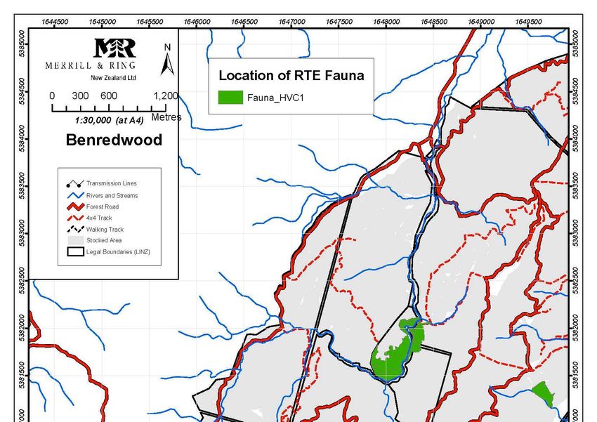
2
1 Management Plan Introduction
This management plan has been produced in accordance with our commitment to international
environmental standards. It contains Merrill and Ring’s general approach to forest management
applied to certified forests under our management. Our management of Blenheim Estate is covered
in this plan.
Management Objectives
The primary management objective of Blenheim Estate is to maximise investment returns by
increasing the net present value of the estate. This will be achieved by progressing the following
secondary objectives:
Optimising biological growth to maximise value,
Optimising tree crop expenses to maximise value,
Maximising residual stumpage,
Managing legal, commercial, and physical risks,
Ensuring that the forest asset is accurately described and modelled,
Operating in a sustainable and ethically responsible manner.
2 Related Documents and Systems
1. Integrated Pest and Weed Management Strategy
2. M&R Environmental Manual
3. M&R Health and Safety Manual
4. M&R Emergency Plan
5. Monitoring Plan
6. High Conservation Value Assessment and Management Plan
7. The Reserves Management Plan
8. Complaints and disputes process
9. Chain of Custody Procedure – Blenheim Estate Ltd.
10. Contracts and Prescriptions
11. Geographic Information System (GIS)
12. Stand Records System (Geomaster)
13. Tigermoth
14. Forest stewardship council / Merrill and Ring policies and procedures.
2
June 2019
3
3 Forest Description
Forest statistics
The Blenheim Estate of 4,752 hectares consists of 7 Forests, located in New Zealand’s Marlborough
region. Of that total, 4,067 hectares are occupied by standing crop or are in the process of being
replanted following harvest, and together are classed as the actual productive forest area. 534
hectares is indigenous vegetation (ranging from stream side reserves, native scrub to tall forest)
managed for conservation purposes. The balance is considered unstocked (unplanted gaps in stands
including skids, firebreaks, etc.) or unplantable (roads, water bodies, transmission corridors, etc.)
and land that is due to be subdivided.
Some 99 % of the planted area is established in radiata pine, with Douglas fir and macrocarpa
making up the balance. After almost a hundred years of trial planting, radiata has proven to be the
species that grows most economically in the soil and conditions of New Zealand.
Forest Name Ownership (ha) Predominant
Joint Freehold Forestry Species
Vent Right
ure
Branch River 579 P. rad
The Terraces 249 P. rad
Hidden Valley 158 P. rad
Benredwood 2,107 P. rad
Chestnut Valley 9 788 541 P. rad
Waihopai Flats 121 P. rad
Koromiko 157 43 P. rad
Total 287 3,922 540
Forest Layout
The forest estate is comprised of 7 small to mid-sized tracts of land. The majority of the forests are
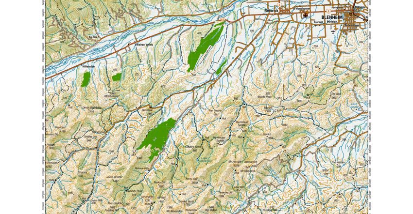
on the Southbank of the Wairau River, a location map of the production forests is in Appendix 2.
3
June 2019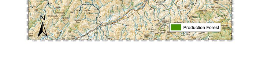
4

      Socio Economic Conditions

Over the last few decades the Marlborough region has faced a dramatic change. Historically the
rural landscape comprised of sheep and beef farming on the flats with forestry in the hills, now the
poor gravely soils lend themselves to viticulture. The Marlborough wine industry accounts for 2,350
direct jobs and an 2,500 indirect jobs to support the industry. Overall the Wine sector provides 10%
of emplyment to the region1. In contrast it is estimated that the NZ forest industry as a whole
provides 9,500 jobs nationally, with up to 300 jobs in the Marlborough region2.

71,084 ha of New Zealand’s production forests are located within the Marlborough region with a
combined Nelson / Marlborough region of 166,230 ha3. This equates to 9.7% of New Zealand’s
production forests. Forestry is an important industry to the New Zealand economy, with expected
export earnings of $5.66 billon with an increase to $6.27 billion in 2021. With 8% of the total cubic
metres shipped from Picton and Nelson.

In contrast the viticulture industry has a combined area of 24,000 ha of intensively farmed annual
grape crop, which equates to 75% of the wine produced in New Zealand4. At the last census the
population of Marlborough was 43,400, or 1% of New Zealand. The majority of the population is
made up those claiming European ethnicity (89.2%) followed by Maori (11.5%), this is lower than
the New Zealand average (14.9%).
With a relatively low population and industry vying for workers, contractors find it is difficult to
attract employees and retain them, this falls in line with an unemployment rate of 4.4%, which is
lower than the national average of 7.1%. The unemployment rate for Maori is also lower in
Marlborough than for the national average, 11.1% versus 15.6%.

Tourism is an important part of the Marlborough economy with visitors enjoying the Marlborough
sounds, fine sunny weather and the wineries playing a key role in bringing tourists to the area, with
annual spend of $387 million5.

      Profile of Adjoining Lands

Merrill and Ring manages forests predominantly on private land within Marlborough. Land
adjoining the FMU is used for a broad range of purposes, including reserves, agriculture, residential,
recreational uses and forestry.

1
  http://www.wine-marlborough.co.nz/about-marlborough/regional-overview-presentation/
2
  https://www.nzfoa.org.nz/resources/file-libraries-resources/discussion-papers/602-nzierreport-2017/file
3
  National Exotic Forest Description as at 1 April 2017 – Published by MPI
4
  http://www.wine-marlborough.co.nz/about-marlborough/key-statistics/
5
          http://www.mbie.govt.nz/info-services/sectors-industries/tourism/tourism-research-data/monthly-regional-
tourism-estimates

                                                                                                                     4
June 2019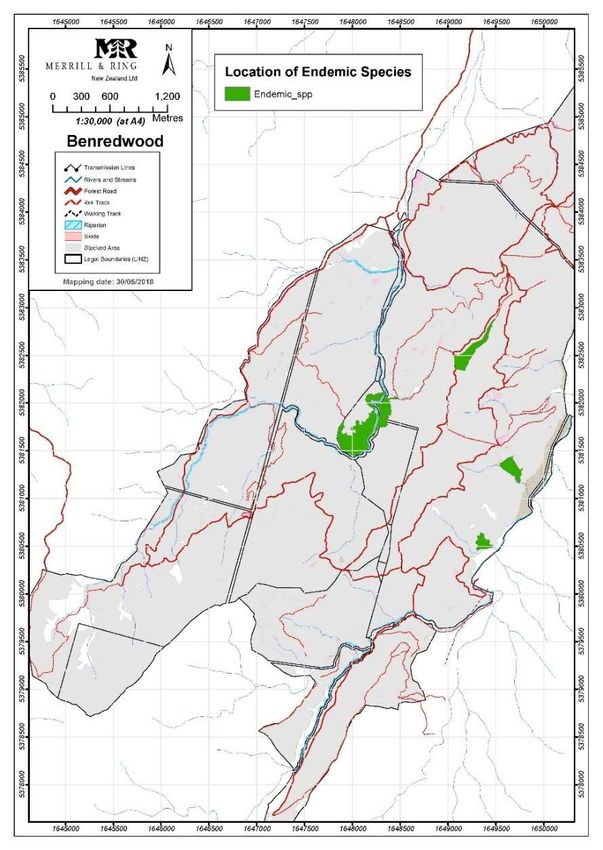
5

4 Environmental Management

All Merrill and Ring forest operations are undertaken in accordance with the Resource Management
(National Environmental Standards for Plantation Forestry) Regulations 2017, relevant Regional
Plans and National legislation and other voluntary requirements, including certification obligations
for THE Forest Stewardship Council.

M&R is committed to maintaining a high standard of environmental and social performance
throughout its forest plantation activities. The company recognises the importance of the
environment and society for the future of its business, for the future of its people and for the future
of the communities in which it operates (See Merrill and Ring NZ Environment and Social Policy).
M&R operates an environmental management system primarily designed to comply with the
Resource Management Act, NZ Environmental Code of Practice for Plantation Forestry,
Marlborough District Council plans and the National Environmental Standards (NES).

Environmental management also includes the identification and management of important values
such as rare, threatened and endangered species, protection of reserve areas and waterways,
carbon management and the control of pests and weeds. The social perspective includes ensuring
that contractors and their workers adhere to health and safety standards, and that engagement
and consultation with neighbours and stakeholders in respect of operations on the forest is
undertaken. The cultural perspective includes consultation with the appropriate iwi and ensuring
that cultural and historic sites and values are identified and protected. The economic perspective
refers to the selection of a species, management and harvesting regime, which provides an
adequate return on investment while minimising the risks of investment.

      Environmental limitations

There are a number of environmental limitations to plantation forestry within the Marlborough
region but most are related to the steep slopes and rugged nature of the topography. The soils
within the region vary with some being more erodible than others. Under the NES most sites within
Blenheim Estate include areas designated high under the erosion susceptibility classification.
These sites provide a challenge to harvesting operations, requiring tracks to be end-hauled and
close supervision of water controls to manage sedimentation.
Permanently flowing streams limit stream crossing constructions dependant on fish spawning and
so careful harvest planning needs be done to ensure operations are not occurring within certain
time constraints.
North-westerly winds are a common feature to Marlborough and can cause significant windthrow
within forests. With large windthrow areas in Chestnut forest, the harvest schedule can be
determined by salvage operations as opposed to harvest age.

                                                                                                          5
June 2019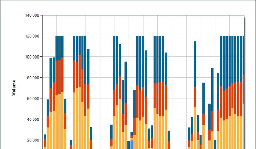
6
The Environment and Forestry Activities
Forestry activities encompassing silvicultural and harvesting operations can have both beneficial
and adverse impacts on the environment, depending on the quality of environmental and
operational management. Well-managed forests can:
Enhance water quality
Stabilise and conserve soil
Provide a buffer against flood flows during storms,
Shade waterways for fish life
Contribute to biodiversity and wildlife habitats
Manage carbon appropriately
Provide recreational, economic and social benefits to the community.
On the other hand, poorly managed forestry activities can have harmful impacts. M&R aims to
identify the potential adverse impacts that its activities may have, and to institute environmental
safeguards to prevent or to minimise the adverse impact from its operations.
In general our approach to environmental management falls into two inter-connected categories:
1. Compliance where M&R work to ensure rules are met and values are protected from our
operations.
2. Active management of environmental values, specifically:
a. Biodiversity, including of:
i. Rare and threatened species management
ii. Management of conservation areas
iii. Integrated pest management
b. Waterways and land
c. Carbon
d. Herbicide management
e. Cultural and historical sites.
Compliance
Compliance is focused on meeting District Council rules and industry best practices. Operational
compliance is managed by the relevant M&R staff member and contractor from planning through
to post operation remediation. Compliance is then audited by an M&R staff member and territorial
authorities. The Technical Forester provides an overview of operational environmental
management and in particular plans audits for high risk operations and council resource consent
conditions.
6
June 2019
7
M&R also operate a system to identify any site specific environmental risks such as streams,
adjacent natural vegetation, archaeological sites, etc., which may not be covered by following the
generic BEPs. Depending on the operation this is completed in the harvest planning stage and
requires the Harvest Co-ordinator to identify environmental or social risks and then implement
measures to minimise potential adverse effects. For establishment operations this is completed as
part of the site assessment. Furthermore, there are safeguards should an environmental risk be
discovered during the operation such as archaeological sites.
4.3.1 Risk Management When Planning and Undertaking Operations
At the beginning of the planning phase of operations staff determine what values may be at risk
from an activity. This is undertaken through our Harvest Planning Checklist or Establishment Plan
where the operation planner considers if the following values may be affected and if so how
management can take these into account:
If a Resource consent required
Archaeological sites present
Adjacent to Native areas - Rare species are present.
Adjacent to (within 10m – i.e. the Riparian Zone) a perennial stream, river, lake or wetland.
Harvesting undertaken by hauler.
Adjacent land owners.
Public utilities such as powerlines, public roads, etc.
Registered easements
Maori or cultural issues.
People are likely to be adversely affected by the proposed operation.
Landscape sensitivity or other restriction indicated in the GIS.
Covenants or easements.
The consequent action will depend on the values and risks identified and may include engagement
with affected stakeholders, a change of operation or approach, protection measures, monitoring or
following one of our Best Management Practices.
A Prescription is developed prior to the commencement of operations which details the work
requirements and standards to operators. Any conditions for the activity, details about the site
terrain, stand data, a description of the job, specific environmental, health and safety requirements,
as well as any specific reporting requirements are incorporated into the prescription. Reference is
also made, where necessary, to the company’s Geographic Information System (GIS) or other key
document or procedure. Environmental hazard identification is completed, and control measures
are documented and communicated to the operator along with the Prescription.
7
June 2019
8

During operations, operators are required to follow the Prescription. Where there is potential for
soil loss or sediment discharge onto sensitive environmental sites, the operator is required to
implement correct water control procedures.

4.3.2 Environmental Impacts and Safeguards

In order to manage Environmental impacts Merrill and Ring undertakes environmental assessments
at the landscape level and on a site or operational specific basis. It is recognised that environmental
components such as soil, water and underlying geomorphology are an essential part of the forest
and broader ecosystem and need sensitive management and safeguarding.

Environmental safeguards have been developed into management prescriptions and operational
procedures, based on a combination of company assessments, external assessments and
operational experience. Each operation is individually assessed and a plan produced detailing site
specific management prescriptions.
Compliance with legal and other regulatory frameworks is monitored both internally and externally
through Council Compliance Officers.

The FMU has numerous operational constraints that arise from environmental compliance. Merrill
and Ring maintains a Geographic Information System (GIS) which records spatially information
relevant to the protection and maintenance of production, environmental and cultural values. The
GIS delineates exclusion and reserve areas and contains environmental information such as known
localities of threatened species and additional biodiversity values, Erosion Susceptibility
Classification, stream catchments, stream widths and visual landscape features. Areas of productive
plantations are also incorporated into the coverage. This information is used during operational
planning primarily in the development of site specific operational management prescriptions.

Sedimentation is a key component that forest operations must manage and limitations around
operations are directed by the Erosion Susceptibility Classification, which is legislated under the
Resource Management (National Environmental Standards for Plantation Forestry) Regulations
2017. This legislation also sets out key requirements forest managers must meet when managing
operations during fish spawning and nesting periods for protected bids. Working around streams
and various set backs are legislated nationally to ensure stream banks are protected and slash is
removed from waterways to prevent damming.

                                                                                                          8
June 2019
9
Merrill and Ring have developed an Integrated Pest and Weed Management Strategy, and an
Environmental Management Manual (EMM) to protect indigenous species and protect the soil and
water resources within its estate.
The Integrated Pest and weed Management Strategy allows for the containment and control of
unwanted pest species which has a direct effect on the welfare of remaining indigenous resources
within the estate. For example the pro-active control of cats helps to protect indigenous native
birds.
It outlines the types operations where chemicals are used and the mechanisms for recording the
type and quantity of chemicals used in forest operations through the use of a chemical register and
chemical reconciliation system. The Environmental Manual and also provides guidelines and
protocols for the proper use of chemicals and environmental incidents.
M&R concedes that under current best practice, chemical applications are necessary to procure
even and quality tree-crops as well as prevent increment loss through the competitive effects of
weeds and the destructive effects of animal pests such as possums. However M&R will always
actively seek management practices that reduce the amount of chemical entering the environment
in its estate. This is of benefit not only to the environment but also M&R as chemicals are expensive
to procure and apply so reducing these activities would have a substantial financial as well as
environmental benefit to the FMU
The EMM outlines company procedure and policy on best practice guidelines in road construction,
harvesting and maintenance operations that change soil or landscape properties and affect the
quality of water flowing in streams and rivers (as well as the downstream effects).
9
June 201910
5 Maintenance and Enhancement of Forest Services
Forests provide a number of services that enhance our environment and community. These services
are managed in a way that will maintain or enhance them; the services include biodiversity,
waterway management, soil conservation and social and economic benefits.
Biodiversity
5.1.1 Falcon
Falcons thrive in plantation forests and are at risk due to nesting on the ground. Key to ensuring the
safety of these birds are identifying if there are nesting pairs within an operational area and
following the NZ falcon Best practice guidelines. Marlborough is fortunate have the Marlborough
Falcon Conservation Trust, which has a falcon breeding program, treats injured birds and can
retrieve eggs from operational or recreational areas where the nest is at risk from predation or
damage. Blenheim Estate Ltd. contribute funding to the trust as it is an opportunity to work with
the community to improve landscape level outcomes in the region.
Sightings of falcons are recorded in Vault and where any nesting sites occur in harvesting areas,
MFCT are able to safely remove the eggs to hatch in the aviary.
5.1.2 Totara Project
Blenheim Estate has a number of Significant Natural areas located in Branch and Benredwood
forests that harbour a number of species endemic to the Marlborough region. Merrill and Ring are
committed to protecting and enhancing these sites through Pest and Weed control. The
enhancement of this site includes extending the native areas through planting Tōtara, using local
genetic seed sources and is detailed in the Blenheim Estate Reserves Management Plan.
5.1.3 Wilding Control
In response to the proposed Marlborough Regional plan Merrill and Ring NZ do not plant Douglas
fir, which is a high risk wildling spread species in the region. M&R’s are committed to managing the
spread of wildlings into reserve areas. In order to enhance native forests within the estate an annual
wilding control program has been initiated.
Control measures are dependent on the size of the trees involved, but generally involve a
combination of poisoning, thinning or manual plant pulling. Sites are prioritised based on size of the
native area, presence of rare, threatened or endanger species and operational constraints.
10
June 201911
Other wilding species and pest plants are dealt when they occur in reserve areas or in accordance
with Regional Pest Plans.
Waterways and Soil conservation
Our attention to waterways (including hydrological flows) is imbedded in our general practices, in
particular Best Environmental Practices. These take into account regional and National rules and
regulations that cover water quality and yield, erosion, compaction and other mechanisms to
protect land and water values. Some key factors or process M&R use to protect and maintain land
and water values include:
• Retaining a mosaic of well spread age classes that minimise effects of forest operations. This
includes reestablishment.
• Through application of BEPs that, for example, prescribes re-plant setbacks and water
controls for earthworks that relate slope.
• Operational planning where high risk situations are identified and taken into account as
operations are planned.
• Operational audits that focus on soil and water values.
• Engagement with regional authorities to ensure compliance with rules and permitted
standards and advise on appropriate activities in high risk areas.
• Post establishment spraying is minimised, where possible spot spraying is undertaken to
ensure some weed cover is on bare land.
In order to enhance waterways, post-harvest assessments are carried out to identify where greater
setbacks than legislated would benefit streams. This assessment determines if land will be removed
from the productive area and set aside as riparian setbacks and managed accordingly.
Social benefits
The FMU is able to offer some unique benefits to the community, such as Paragliding, which is
managed under a permit system. Hunting and trapping are also offered and outlined under the
Forest Access Policy.
The FMU provides economic benefit to the local community though direct employment of
contractors and indirect employment of industry support services to contractors and employment
of staff at local timber manufacturing, to which logs are supplied.
11
June 201912
6 Forest Management & Operations
Introduction
M&R manages the FMU in the Marlborough region of New Zealand to provide logs for its customers
derived from fast growing, sustainable Pinus radiata forestry plantations. The extent to which the
business will prosper in the future depends greatly on the quality of the natural and physical
resources that provide the foundation for our business. The company is committed to sustaining
the natural resource base, not only for the future of the company, but also for the future of the
communities in which M&R operates.
The forest estates are managed consistent with the forest management policy and to meet the five
Year Plan, in particular to ensure that the management of the forest is sustainable, from an
environmental, social, cultural and economic perspective.
M&R aims to intensively manage the forest estate to supply a range of log products. Intensive
management involves best practice land preparation, planting of tree stocks, risk management,
forest health and thinning.
The evaluation and selection of a silvicultural system for the FMU, is based on recognised forest
practices and guidelines, taking into account management objectives for the specific site. The
primary objectives in selecting a fit for purpose silvicultural system is to maximise the value of wood
products grown and harvested from the land whilst maintaining the long term productivity of the
land and other environmental values.
In determining the appropriate silvicultural system, a number of factors need to be considered.
These include, but are not limited to:
Plantation management objectives;
Species and regime selection;
Rotation length;
Site environmental factors;
Natural and cultural values;
Fire management requirements;
Commercial / marketing factors;
Plantation investment requirements;
Lease agreement terms and conditions;
Operational constraints; and
Community expectations.
12
June 201913
Species Selection
Pinus radiata is the forest species selected over decades of trials in New Zealand and is grown
primarily as a sawn timber resource and provides logs to local mills. It is frost resistant, tolerant of
dry sites and capable of satisfactory rates of growth on less fertile sites. Other minor species can be
grown in the regions and the FMU contains minor areas of Macrocarpa and Douglas fir. However,
under the Marlborough District Plan Douglas Fir is no longer permitted to be planted.
Establishment and Silviculture
The following table outlines the typical establishment and silvicultural regime currently practised in
the FMU. The regime often varies depending on site (terrain, soil, elevation, weeds) and risk
(environmental, community, safety) factors.
Year Operation Description
-1 Land preparation On flat to rolling areas - line rake / windrow slash
-1 Weed control Prior to planting generally with a mix of metsulfuron and glyphosate
by air.
0 Planting 1,000 stems per hectare pinus radiata
1 1st Release Undertaken to release from weed competition and to reduce
frosting. Usually with a mix of hexazinone and terbuthylazine applied
by ground. Where steep terrain makes it unsafe to apply by
knapsack, it is applied aerially.
1 Regen pull Only on areas with high regeneration. Undertaken by hand.
2 2nd Release Only on high weed growth. Undertaken to release from weed
competition. Usually with a mix of hexazinone and Terbuthylazine
applied by aircraft. Other herbicides and application methods used
dependant on weed species and risks.
3 Boron treatment Following foliage sampling, areas identified that are deficient in
boron receive an aerial application of ulexite
6 Prune Determined on a case by case assessment
10 1st Thin to waste 10m mean crop height
All Pest control Generally undertaken by permit.
28 Harvesting Dependant on stand characteristics. See harvesting for more detail.
13
June 201914
Establishment
Each year M&R examines the areas available for establishment to determine land preparation,
which includes cultivation, raking, skid rehabilitation, and weed control, taking into account the
needs of each site.
The establishment phase is crucial to obtaining a quality crop. As such we aim for high seedling
survival and initial growth rates in order to compete with other on-site vegetation. Key objectives
at establishment to ensure a good crop are:
• High quality and healthy tree stock properly handled to the site
• Cultivation of the soil;
• Placing the tree roots in the soil in a position that encourages stability;
• Reducing competition from other vegetation in the first years of growth.
6.4.1 Weed control
Herbicides are used for weed control and are usually confined to the year of planting and the
following year. Successful establishment means that herbicides are only required to be used up to
two times every 25 to 30 years. Applications by aircraft are carried out prior to planting and in
secondary release programs where broom is present. Due to the highly erodible soils in the
Marlborough region spot spraying after planting is typically undertaken in most forests areas. Areas
that pose risks to the health and safety of our contractors are release sprayed aerially.
Herbicides are selected based on their ability to desiccate and/or kill the target weed species at the
same time as being safe to use (i.e. non-toxic to non-target species, such as animals and humans)
and break down quickly in soil and water to a safe organic substance. Application plans include
strategies to protect watercourses, wildlife habitats and areas of native forest.
Silviculture
The basic silviculture regime for radiata pine is thin to a minimum of 500 stems per hectare.
Depending on site productivity pruning maybe undertaken, with these stands thinned to 350 stems
per hectare.
Stands are thinned in order to provide the optimum growing space for selected crop trees enabling
us to maximise their economic return. The aim is to thin out the smaller or poorly formed trees,
leaving the bigger, better formed trees to grow on. Thinning to waste operations results in the
thinned stems being left on the forest floor to decompose. Due to the type of terrain the forests
occupy Production thinning is not a viable option.
14
June 201915
Other species that make up the estate include Douglas fir and Macrocapa. Thinning age differs for
these species, with Douglas fir being thinned at age 15 and the macrocarpa at age 10.
Pests and disease
Currently there are no diseases regularly treated within the forest estate. Merrill and Ring have
commenced independent Annual Forest Health surveys to ensure any disease outbreak is identified
and managed.
Pests in the forest estate include possum, which can attack the growing tips of trees causing stem
malformation and die-back. Furthermore they eat native tree species and predate native wildlife
in conservation reserves and parks. Rabbits and hares can also be a pest in the first two years after
planting, as they can eat the tops of young trees. Due to historical work undertake by the Animal
Health Board possum numbers are quite low, and any additional control is currently undertaking
using traps. Pigs and deer are controlled through hunting.
Monitoring of Silvicultural Systems
The plantation monitoring program, carried out to ensure acceptable stocking, performance, and
quality, involves surveying and assessment of the recently established planted area up until age 3
to ensure successful reforestation has been achieved at these critical early stages of the plantation
life cycle. Monitoring includes:
Site preparation quality control;
Planting quality control;
A survival assessment no more than 12 months post establishment to ensure adequate
stocking levels have been achieved; and
Annual plantation health assessments.
Plantation assessments and monitoring occur throughout the rotation (not simply restricted to the
early operational phases). For example, growth plots, are being measured and assessed as required
to ensure data is collected to validate that sustainable forest management practices are being
implemented.
15
June 201916
Harvesting
M&R use a wood flow program called Tigermoth to determine how and when to harvest the tree
resource. From this a 5 year harvest plan is developed, and then translated into an annual harvest
plan.
Rate of Harvest
M&R endeavours to harvest its forest resource as closely as possible to the optimum tree age for
each stand.
A major determinant on the level of harvest is the age class distribution. Our aim is to harvest close
to optimum tree age rather than maintain a set yield. An uneven age class distribution, (with
different areas of trees in each age class) is a consequence of the amount of forest established in a
given year.
The table below shows the age class distribution,
Age 1- 10 years 20% of the estate
Age 11 – 20 years 40% of the estate
Age above 20 years 40% of the estate
The ability to alter the harvest to respond to market demand fluctuations from year to year does
exist. Harvesting is usually scheduled at 28 for radiata pine and around age 40 for Douglas fir. Actual
timing depends on stand and market conditions.
The rate of harvest can be predicted over the rotation of the forest and the graph below shows the
volume for the next 70 years.
16
June 201917
Figure 1 Predicted harvest for the next 70 years
Extraction Techniques
M&R uses three basic criteria to ensure the right harvesting methods are employed:
1. Health and Safety: the method is the most appropriate for the topography and nature of land so
that the potential for injury is minimised.
2. Environmental: the method, which creates the least impact on the environment.
3. Economic: the method, which is the most cost-effective for the area, taking safety and
environmental considerations into account.
17
June 201918
Conventional Harvesting
Conventional harvesting is characterised by log making on local skid sites. Various methods are
used, including ground based, tethered, swing yarder and hauler tower on steeper areas and
selection of these will depend primarily on the terrain.
Harvesting and Slope Decisions
M&R is committed to adopting harvesting techniques and technology that minimises the impact on
the environment and reduce the risk of accidents and injuries.
To meet these objectives, land is divided into five terrain types and use the appropriate machinery
configurations on each type, which are typically as follows:
1. Flat (FLT 0-20 degrees). A mechanical harvester fells the tree and removes most of the
branches, leaving the residues on the cutover land. Logs are removed with rubber-tyred
skidders fitted with mechanised grapples.
2. Rolling, steep (RST 20-45 degrees). This includes land with areas that are unable to be
harvested easily with rubber tyred skidders, and which therefore requires tracked machines
either to provide tracks on which rubber tyred skidders can work, or to actually extract the
stems. In this type of extraction, traditionally manual (chainsaw) clear-felling was likely to
be used, but has been replaced by self-levelling or tethered (by wire cable) harvesting
machines. Excavators fitted with logging grapples are sometimes used to “shovel” full length
stems to points that the extraction machines are able to work safely.
3. Steep, short (SST 30 degrees or more, but less than 500 metres haul distance). This country
is too steep for skidders or tracked machines to work safely, and consequently haulers are
used in this operation. The predominant hauler used is the “swing yarder”. This is a hauler
with a short tower, and it has the ability to work close to the edge of the slope, swinging the
stems to one side of the machine before they are moved to a skid site (flat open areas within
the forest). The swing yarder is a flexible machine that can be moved and set up relatively
easily, and can use a variety of harvesting techniques to suit any given situation or difficulty
factor. Falling may be by tethered harvester or manual by chainsaw. If Stands have
favourable lower slopes where tracks can be installed for a skidder, then ground based
tethered harvesting as above for Rolling, steep can be used.
4. Steep, long (30 degrees or more but greater than 500 metres haul distance). This country is
also too steep for skidders or tracked machines and requires another type of hauler. Tall
poles or towers to which the haul ropes are attached are used to provide lift, so that stems
are hauled to the landing sites with minimal environmental impact. Falling is generally
manual but tethered machines can sometimes be used.
18
June 201919
Tethered harvesting machines are now utilised on slopes over 20 degrees as a safer means to
undertake tree falling rather than manual use of a chainsaw.
7 Monitoring Plan
The purpose of a monitoring program is to assess the condition of the FMU, yields of forest
products, chain of custody, management activities and any social and environmental impacts. Those
elements to be monitored and the frequency and intensity of the monitoring is set out in the
Monitoring Plan.
Monitoring Forest Growth and Dynamics
A critical component of management planning and continuous improvement is understanding the
available forest resource. A key component of this is through forest measurement and mapping. In
order to accurately determine the area of net stocked area, reserves, infrastructure and riparian’s
these must first be mapped using aerial photography.
Data collected early in the rotation during establishment and silvicultural tending quality control
assessments is captured in Geomaster and provides base data for future operations.
Preharvest inventory is undertaken at around 3-5 years prior to harvest to determine, to a very
detailed level, the predicted yield and product outturn of stands at harvest. This data is then used
post-harvest to reconcile the actual yields to those predicted.
The forest growth and dynamics is monitored at several stages of forest development, including:
• QC Following planting, pruning and thinning
• Survival surveys
• Foliage sampling
• Forest health surveys
• Pre-harvest inventory
• Post-harvest reconciliation.
19
June 201920
Social impact assessments
Merrill and Ring understand that forestry operations we undertake can affect our neighbours in a
variety of ways. The social impacts of Harvesting and cartage operations are assessed during the
harvest planning operation. Due to the small size of the estates managed, Merrill and Ring are able
to communicate directly with those neighbours who have the potential to be affected by
operations. This is done either face to face or verbally over the phone. Harvest prescriptions, cut
cards are updated with any requirements the neighbours have requested, such as calling them
when working close to the boundary or if there are trucking restrictions.
Feedback from neighbours during the harvesting operations is generally by phone or face to face.
Historically most concerns from neighbours area regarding cartage times, dust and working along
boundaries where there are fences or animals present. Any concerns from the neighbours are acted
upon in a timely manner.
Dust: complaints from neighbours regarding the level of dust. We work to a restricted speed limit
along the access road and from time to time this needs to be reinforced with cartage contractors.
Additionally we apply dust suppressant and use a water truck to reduce the level of dust.
Prior to any spray operations Merrill and Ring contact neighbours on the boundary with the affected
forest to notify them of the operation. The Forester will discuss the operation and address any
concerns they may have. Where there are concerns that need to be addressed these will be added
to the prescription. The Forester remains present during the spraying of sensitive boundaries to
ensure Merrill and Ring are present to mitigate any neighbour concerns.
A database of social impacts is kept and details the steps taken to manage the impacts of operations.
20
June 201921
8 Spatial Information and Decision Support Systems
M&R currently has an integrated GIS system that contains detailed spatial and stand information
data layers for all forests in the resource. The current GIS allows M&R to produce a variety of high
quality maps with a large array of necessary information displayed including legal and stand
boundaries, protected areas, land-use capabilities, tenure and related spatial information, such as
contours, hydrology and transportation features, these are stored as an ESRI Spatial database.
The GIS is used to plan harvesting operations, storing locations of landings and planned roads. All
maps and mapping systems are generated from these GIS systems and will continue to be so into
the foreseeable future.
M&R uses the ATLAS Technology Suite (e.g. ATLAS Geomaster) for our stand record system, forestry
and harvesting management systems. Atlas is the leading provider of forestry software within New
Zealand and was developed by Scion Research, formerly known as Forest Research Institute.
Health, safety and environmental auditing is managed with an online mobile system called Vault.
This allows all audits and checklists to be electronic and available without data coverage. Corrective
actions can then be tracked and managed to ensure that compliance is achieved.
21
June 201922
9 Forest Protection
Fire Management
There is a restricted fire season operated within the MDFA region, which normally runs from 1
October until 30 April, but this is contingent on weather conditions. During the restricted fire
season, all fires require a fire permit issued by a Rural Fire Officer.
Security
9.2.1 Access, Permits and Events
M&R maintains tight control of access through a thorough permitting system where applications
are made on a purpose designed form. All drivers and their vehicles must obtain access permits
which are only approved when the following is provided:
1. Valid reason for entry.
2. Valid full drivers licence.
3. Vehicle registration plate number, make and model.
4. Public liability (minimum $5 million), firefighting (minimum $1 million) and vehicle liability
insurance (minimum $5 million).
These processes ensure M&R approves only bona-fide and qualified access and can pass on safety
and behavioural information. Permits enable M&R to determine if the person is appropriate to
enter the forest (i.e.: checking driver license, firearms license, previous history - trespass, etc.) and
to pass on behavioural information such as safety messages, road rules, closed areas (i.e.: where
harvesting activities are happening), hazards etc.
9.2.2 Policy
Recreational access is generally managed through the Access Policy. The policy addresses M&R’s
right to protect the forest and assets through access control.
The key features of the policy are:
• Provides for the public to hunt within specified forests it manages and access fishing rivers by
vehicle, during daylight hours on weekends when the fire danger is low (which includes the
period from May to September).
• M&R recovers some of the costs associated with recreational access through a registration fee
of $50 per person per annum. Once registered, a person can enter as necessary during that year.
- To be valid, the permit holder must sign and accept access and safety conditions.
22
June 201923
Forest Communications
There is cellular coverage across the estate, however there are areas in each forest where the
reception is patchy, therefore communication within the forests is through the M&R Radio
Network. This operates on line of sight, and is key in managing safety within a forest.
When working alone in the forest staff carry personal locators have a check procedure to ensure
safety.
23
June 201924
10 High Conservation Value (HCV)
Whilst M&R protect and manage all conservation areas, in particular those that meet the NZ Forest
Accord we prioritise active management to those with special or particular values. In particular
areas with values that meet high conservation values (HSV). Each site has specific management
aimed at their identified or significant values. M&R will progressively assess new areas adjacent to
harvest sites for HCV values with the objective to protect and enhance these areas using detailed
in the Reserves Management Plan.
The following sections provide definitions of HCV and how they are assessed and managed.
High Conservation Values
Principle 9 of the Forest Stewardship Council deals with High Conservation Values and places
significance on the maintenance and protection of areas identified with these values.
M&R recognises the importance of High Conservation Value areas and are committed to identifying,
protecting and where practical enhancing forest that is recognised as having high conservation
value. High Conservation Value is identified using the definition (below). Native areas are assessed
through reviews of existing relevant assessments, consultation with stakeholders and undertaking
assessments in forest areas that may contain high conservation values.
High Conservation Value (HCV) are areas that possess one or more of the following attributes:
HCV1. Forest areas containing globally, regionally or nationally significant concentrations of
biodiversity values (e.g. endemism, endangered species, refugia).
HCV2. Forest areas containing globally, regionally or nationally significant large landscape level
forests, contained within, or containing the management unit, where viable populations of most if
not all naturally occurring species exist in natural patterns of distribution and abundance.
HCV3. Forest areas that are in or contain rare, threatened or endangered ecosystems
HCV4. Forest areas that provide basic services of nature in critical situations (e.g. watershed
protection, erosion control).
HCV5. Forest areas fundamental to meeting basic needs of local communities (e.g. subsistence,
health).
24
June 201925
HCV6. Forest areas critical to local communities‟ traditional cultural identity (areas of cultural,
ecological, economic or religious significance identified in cooperation with such local
communities).
10.1.1 Indigenous Biodiversity
Within the FMU M&R actively consulted with DOC and the QEII National Trust for the management,
restoration and conservation of Native areas which is detailed in the Blenheim Estate Reserves
Management Plan. Identification of high biodiversity values are determined by analysis of the
following criteria:
They contain rare, endangered or threatened ecosystems.
They contain biodiversity values that are globally, nationally or regionally significant as
described by the NZ National Policy Statement on Biodiversity.
The high biodiversity values are either viable populations or ecosystems.
Are crucial to the survival of category one endangered species.
10.1.2 Significant Natural Resources
Significant natural resources within the forest estate are identified through the relevant regulatory
authority plan as either a municipal water supply catchments or as critical for erosion control.
10.1.3 Community and Cultural Value
Areas of high community or cultural value are identified as having the either of the following
characteristics:
Having high archaeological significance that is of national or regional significance.
Having community values or significance that is essential to the identity of the wider
community in which it exists.
While HCV are determined through this process the identification and management of HCV also
includes engagement.
25
June 201926
10.1.4 Stakeholder Engagement
Should new areas be identified or reviews of plans undertaken, M&R engages and where relevant
inspects, these areas with relevant stakeholders such as (DOC, iwi and local experts) to determine
if the identified values meet the definition of HCV. The following steps shall be taken;
stakeholders with interests in High Conservation Values will be invited to participate in
consultation via email or phone with sufficient notice;
records of these invitations and subsequent consultation will be maintained in a
stakeholder engagement register;
the consultation process will be open to parties claiming an interest in or affected by the
implementation of this plan;
all identified stakeholders will be provided access to sufficient information; and
Stakeholders will be provided copies of the final plan.
M&R will use the discussions with these stakeholders to develop management and
monitoring procedures for any areas that are agreed to have HCV.
10.1.5 HCV Conservations Areas
The QEII trust was engaged to undertake assessment of the native areas within the FMU with the
intent to legally protect them with a covenant. As part of the assessment process, the identification
of native fauna and flora was recorded in a database and the threatened status was determined for
each species. Threatened species are classified under the New Zealand Threat Classification system
and is managed by the Department of Conservation. Under this HCV element, forest areas with
significant concentrations and priority sites for these species are considered HCVF. The table below
details threatened species within the FMU.
The Management Plan needs to be read in conjunction with the High Conservation Value
Assessment and Management Plan and the Reserves Management Plan.
26
June 201927
Table 1 Threatened Fauna
Forest Location Species Common Threatened
Name status
Benredwood Southern Kanuka Forest Petroica australis South At risk -
Musgrave Brook Island declining
Northern Gullies robin
Southern Kanuka Forest Falco Bush At risk -
Jack novaeseelandiae falcon recovering
ferox
27
June 201928
Table 2 Threatened Flora
Forest Location Species Common Threatened status
Name
Benredwood Northern Gullies Celmisia insignis Waihopai At risk – naturally
Summit rocks daisy uncommon
Jack
Summit rocks Coprosma acerosa At risk - declining
Jack Botrychium Parsley At risk – naturally
australe fern uncommon
28
June 201929
Endemic Species
Endemic species are those found in a particular region and nowhere else in the world. Since these
species are often not widespread and may be confined to only one or two areas, they can be of
great conservation priority. Under this HCV element, forest areas with significant concentrations
and priority sites for these species are considered HCVF. The table below details endemic species
to Marlborough within the FMU.
Forest Location Species Common Threatened
Name status
Benredwood Northern Gullies Pachystegia insignis Marlborough Marlborough
Summit rocks rock daisy endemic
Musgrave Brook
29
June 201930
Other Conservation Reserve Areas
Managing conservation areas (natural areas or reserves) is a key component of Environmental
management which is primarily undertaken through the Reserve Management Plan.
In general reserve management is relatively simple where pest control and wilding removal produce
the best biodiversity results. Pest control is mostly achieved through hunting and trapping. Wilding
control will be undertaken within identified reserves.
10.3.1 Management objectives
To maintain and where possible enhance the viability of threatened species populations that occur
within the FMU.
10.3.2 Threats to the High Conservation Values
• Loss of habitat due to operational activity.
• Introduction of weeds, diseases and pests.
10.3.3 Management Strategies
In order to achieve sustainable forest management goals, forest operations comply with the
Resource Management (National Environmental Standards for Plantation Forestry)
Regulations 2017.
Operations that have the greatest potential to affect the environment, such as Harvesting,
earthworks, quarrying and stream crossings, require detailed management plans for
managing environmental risks and preventing damage to native forests.
Undertake training and awareness of staff in the identification and management of
threatened species.
Consultation with the Department of Conservation, Queen Elizabeth II Trust and local
council, as to best undertake restoration operations where required.
Ensure plantation operational activities do not impact on natural forest or other non-
productive areas within the FMU.
Undertake active management works as required and identified through monitoring
activities.
Continue to undertake threatened species management on Blenheim Estate, in consultation
with relevant authorities and experts.
Undertake active management works as required and identified through monitoring
activities.
30
June 201931
Implement measures to ensure protection of HCV areas (Precautionary approach, setbacks,
etc.), where plantation harvesting or management activities are undertaken in close
proximity.
Protecting biodiversity values, retention of natural forest across the landscape; retention of
streamside reserves; management of risks from weeds and diseases.
Comply with plantation operational procedures and identified thresholds, within the
Environmental Manual.
Where applicable and appropriate develop site specific Management Plans for HCV sites.
10.3.4 Monitoring
Monitoring is undertaken by M&R or at times by engaging an expert. The method of monitoring
will depend on the high conservation values and the outcome of consultation with stakeholders.
Monitoring is undertaken by visual inspection, in particular for degradation, pest damage,
unauthorised activity and wilding pine presence.
5 yearly desktop assessments will be carried out to determine the likely presence and distribution
of rare, threatened and endangered species. Marlborough district council monitor the SNA areas
and provide reports. Any areas that are covenanted will also be monitored by the QEII trust every
two years.
Complete monitoring activities throughout the FMU in accordance with Merrill and Rings
commitments to managing wilding pines and weed species in HCVF
Monitor operations to ensure compliance with the requirements specified in Harvest
Management Plan or Earthworks Management plan. Monitoring results are recorded
through the Vault Environmental Checklists for operations.
Where species change category through legislation, Merrill and Ring will ensure any impacts
on the FMU are considered.
Harvesting and Earthworks are subject to external checks by the Regional Council to
demonstrate compliance. Auditing results will be included in Annual Monitoring Report.
Effective monitoring, management, and research of HCVs is collated and summarised
annually within the HCV Monitoring Report.
10.3.5 Responsibility
Operational Foresters
Technical Forester
11 Culturally and Historically Significant Sites
31
June 2019You can also read