Heritage Assessment: Ruapekapeka Pa and Battlefield - Maria Butcher May 2011
←
→
Page content transcription
If your browser does not render page correctly, please read the page content below
Heritage Assessment:
Ruapekapeka Pa and Battlefield

                       Maria Butcher
                            May 2011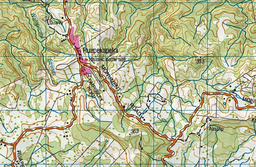
Contents

 Site Overview                                                                               3

 History Description                                                                         3

 Fabric Description                                                                          9

 Cultural Connections                                                                        11

 Significance                                                                                11

 Management Chronology                                                                       13

 Management Recommendations                                                                  14

 Conclusions                                                                                 15

 Sources Consulted                                                                           16

 Appendix A: Aerial photograph of Ruapekapeka Historic Reserve                               18

 Appendix B: Archaeological Plans                                                            19

 Appendix C: Contemporary Maps and Plans                                                     21

 Appendix D: Planting Plan                                                               23

Heritage Assessment: Ruapekapeka Pa and Battlefield
Maria Butcher
Department of Conservation
Whangaeri Area Office
2011
Cover Image: Waharoa at the entrance of the pa carved by Te Warihi Hetaraka (photo credit:
Department of Conservation)
Image this page: Department of Conservation
Peer Reviewed by: Joan Mainguy

                                                                                              2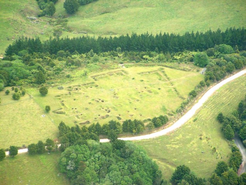
Site Overview
It is difficult to overstate the significance of Ruapekapeka Pa and Battlefield. The battle
in 1845/6 was the culmination of the War of the North, when Maori stood against the
might of the British Empire. It was an armed response to the Treaty of Waitangi,
seeking to prevent the erosion of Maori mana. Ruapekapeka is the best preserved of all
the New Zealand Wars sites, a tangible connection to events which shaped New
Zealand society as it is today. 1

The Ruapekapeka Historic Reserve is accessed by a gravel road off State Highway 1,
about 35 km north of Whangarei. Nine and half hectares in size, the reserve
encompasses the pa itself, the British forward position, and part of the British main
camp. The pa and British forward position are mown on a regular basis, and the reserve
boasts a sealed car park, formed tracks, interpretation signs, and a beautiful carved
waharoa (entranceway).

Figure 1: Location Map

History
At the beginning of 1846, a small army of British soldiers, sailors, and Maori allies set up
a camp in a rugged and isolated spot not far from Kawakawa. The heavy artillery at
their disposal included three massive 32-pounder cannons, which were aimed at the top
of a knoll to the south-east of the camp. The target: Ruapekapeka Pa, a formidable
fortification built by the military genius Te Ruki Kawiti and manned by fierce Ngapuhi
warriors. On January 10, the British focussed all of their firepower on the northwest
corner of the pa:

      When all had been got ready, the soldiers began to fire in earnest – rockets,
      mortars, ship guns, long brass guns – all burst out firing at once. We were almost

1
 D. Green. 2010. Battlefields of the New Zealand Wars: A Visitor Guide. p. 43; J. Gardiner. 1983.
Ruapekapeka Pa Historic Reserve: Management Plan Proposal.

                                                                                              3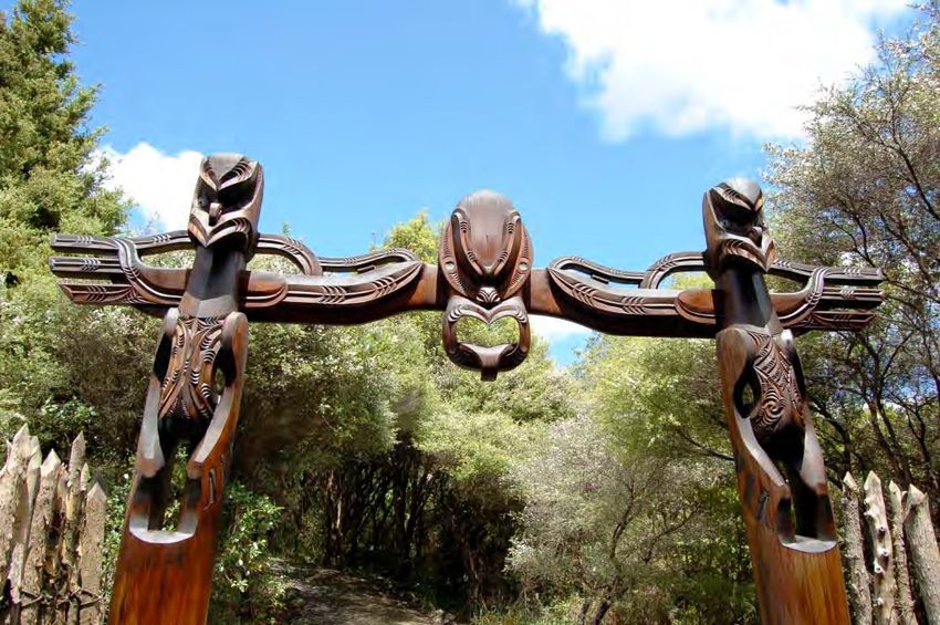
deaf with the noise, and the air was full of cannon balls. The fence of the pa began
      to disappear like a bank of fog before the morning breeze. 2

The roots of the conflict can be traced back to the moment Captain Cook set foot upon
New Zealand shores. Events which triggered outright war relate to the political and
economic situation after the Treaty of Waitangi in 1840. In short, the new colonial
government made decisions which had negative impacts upon the lives of Northland
Maori. Kororareka (Russell) went into decline when the capital was shifted to Auckland:
it was no longer a lively, raucous hub of commercial opportunities for Maori. In
addition, the Chiefs were prohibited from charging anchorage fees, and restrictions
were placed on the felling of certain types of timber. 3 Basically, the British attempted to
impose their own sovereignty without regard for existing chiefly authority. 4 The
influential Chief Hone Heke summarised the situation in an eloquent manner when he
went to visit his distant relative, Te Ruki Kawiti:

      He bought with him a mere 5 smeared with human dung. No explanation was
      needed, the meaning was obvious. Someone had defiled the mana of Ngapuhi and
      such a challenge must be met! 6

The name Hone Heke is synonymous with the War in the North, but Te Ruki Kawiti
played an equally important role. The two men were quite different: Kawiti was of an
older generation, wiser and more experienced. Heke’s character has been described as
a “mingling of passionate patriotism, ambition, bravado, vanity, and … shrewdness”. 7
He was also fair-minded, and at first he sought peaceful solutions to the perceived
problem of government interference. 8

Against a background of growing discontent, Heke directed his attention to the Union
Jack flying atop the flagstaff at Kororareka. He recognised the flagstaff as a symbol of
British sovereignty, and in July 1844 he chopped it down. In March 1845 Heke attacked
the flagstaff for the forth time, and Kawiti lead a co-ordinated attack on the troops
guarding the town. 9 The British were defeated and driven out of the town, despite the
presence of the army and the Royal Navy. 10

The causes of the War in the North cannot, of course, be condensed into a few
sentences. For one thing, it was not a straight forward case of Maori vs. the Crown. A
faction of Nga Puhi led by Tamiti Waka Nene (and others) fought alongside the British,
which remains something of a delicate subject among Northland Maori today. 11
Historian Ralph Johnson emphasises that these men were not “loyalists” to the Crown.
Many of them agreed that the government was not honouring the Treaty of Waitangi
(Te Tiriti). 12 However, they disagreed with Heke’s reaction, believing that cutting down
2
   F. E. Manings, 1862. p. 42.
3
   J. Belich. 1988. The New Zealand Wars. Penguin Books. p. 30-34; J. Cowan. 1922. The New
Zealand Wars and the Pioneering Period (vol. 1). p. 15-16. R. Johnson, 2006. The Northern War
1844-1846. p. 22.
4
   R. Johnson. 1996. p. 22-23.
5
   A mere is a short flat weapon.
6
   T. Kawiti. 1956. Heke’s War in the North. Te Ao Hou 16 p. 38.
7
   J. Cowan. 1922. p. 13.
8
   J. Belich. 1988. p. 30-33.
9
   T. Kawiti. 1956 p. 39-40; Belich, J. 1988. p. 36-41.
10
    J. Belich. 1988. p. 37.
11
   See J. Belich. 1988. p. 30-35.
12
    R. Johnson. 1996. p. 213-220.

                                                                                          4
the flagstaff contravened the tapu surrounding Te Tiriti. 13 There were also grave
concerns that Heke had aspirations of becoming the most powerful Ngapuhi chief. 14

On 8 May 1845 British forces attacked Heke at his incomplete pa at Puketutu,
withdrawing after fierce skirmishes on open ground. 15 A few months later Heke
suffered his first defeat, but it was not at the hands of the British. Te Taohui and Tamiti
Waka Nene attacked Heke’s pa at Te Ahuahu, and Heke was defeated and severely
wounded. 16 Meanwhile, Kawiti focussed his attention on the pa of his ally Peni Taui,
located at Oheawai. Kawiti and Peni Taui united to transform the pa into a formidable
fortress, incorporating many of the defensive features later seen at Ruapekapeka.

The battle at Oheawai was an unmitigated disaster for the British. Their commander
was Colonel Despard who is remembered, perhaps unfairly, as an incompetent
blustering fool. 17 He ordered a frontal assault which was (in retrospect) doomed from
the outset. Oheawai Pa was fortified with two rows of timber palisades with loopholes in
the base for directing musket fire. Projections in the perimeter allowed flanking fire to
be directed at the attackers as they struggled to breach the defences. 18        Within
minutes, 34 members of the storming party were dead and 70 injured. 19 From a
survivor:

      The whole front of the pa flashed fire, and in a moment we were in the one-sided
      fight … Not a single Maori could we see. They were all safely hidden in their
      trenches and pits, poking the muzzles of their guns under the foot of the outer
      palisade. What could we do? 20

Kawiti and his warriors set out to build a new pa at Ruapekapeka. Tools were brought
from Kororareka, and two cannons were brought up the river on canoes and hauled
overland. 21 Kawiti chose a knoll with steep slopes on three sides, surrounded by thick
puriri forest. Ruapekapeka was a “remarkable fortress and a masterpiece of military
engineering.” 22 The outer defences were similar to those at Oheawai: a double-row of
massive puriri palisades and a rifle trench around the perimeter designed to prevent
enfilading fire. 23 The interior defences were even stronger; there were deep holes all
over with bombproof covers of timber and earth, tunnels, breastworks and cross
fences. 24

13
   R. Johnson. 1996. p. 213-221.
14
   R. Johnson. 1996. p. 216.
15
   J. Belich. 1988. p. 41-44.
16
   J. Belich. 1988. p. 45-46.
17
   e.g. J. Cowan. 1922. p. 58; The New Zealander, Saturday 24 January 1846; Manings. F. E. 1862.
History of the War in the North of New Zealand against the Chief Heke in the year 1845. p. 41. For
an alternative viewpoint see J. Belich. 1988. p. 47-54.
18
   There is a detailed description of the pa at Oheawai in J. Cowan. 1922. p. 49-52.
19
   See R. Johnson. 1996. p. 308.
20
   As told by Lieutenant W. Free, quoted in Cowan 1922 p. 61.
21
   T. Kawiti. 1956. p. 42.
22
   R. Johnson. 1996. p. 364.
23
   The rifle trench had earthen banks projecting inwards from alternating sides, leaving a gap big
enough for the defenders to move from one part of the trench to another. This prevented an
attacker from standing at one end of the trench and firing down its entire length.
24
   Diary of C. Bridge, 11 January 1845.

                                                                                                5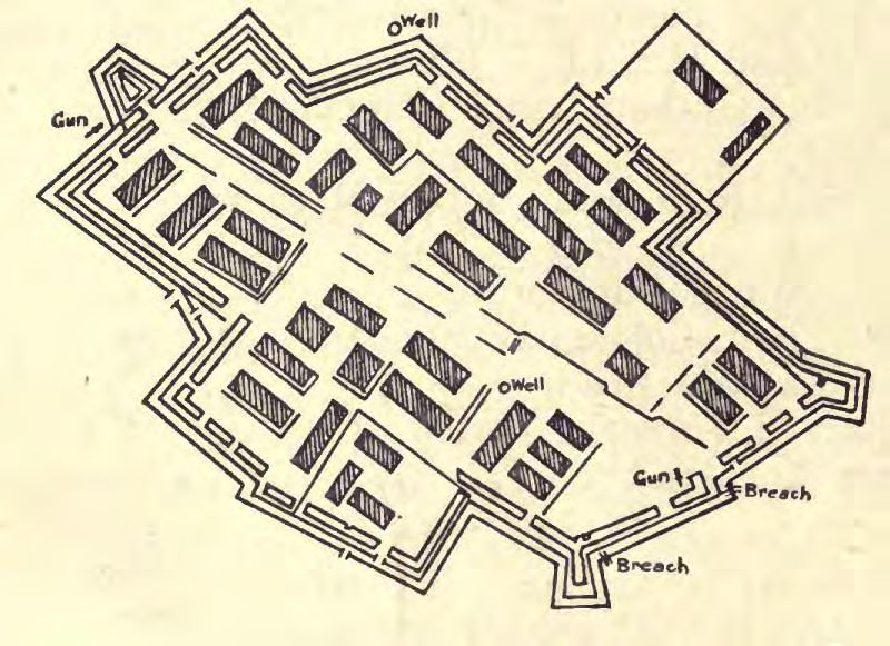
Figure 2: Cross section of the palisades and firing
                                            trenches from Cowan 1922.

Figure 3: Plan of Ruapekapeka from Cowan 1922; note the 2 wells.

Meanwhile, Despard and the newly-appointed Governor Grey began to organise the
third British expedition inland. The purpose: to meet Kawiti at Ruapekapeka. 25 The
force assembled was the largest yet, comprising 800 regulars, 60 volunteers from
Auckland, a naval brigade of nearly 400, and 80 sailors and artillerymen from the East

25
     J. Belich. 1988. p. 58.

                                                                                            6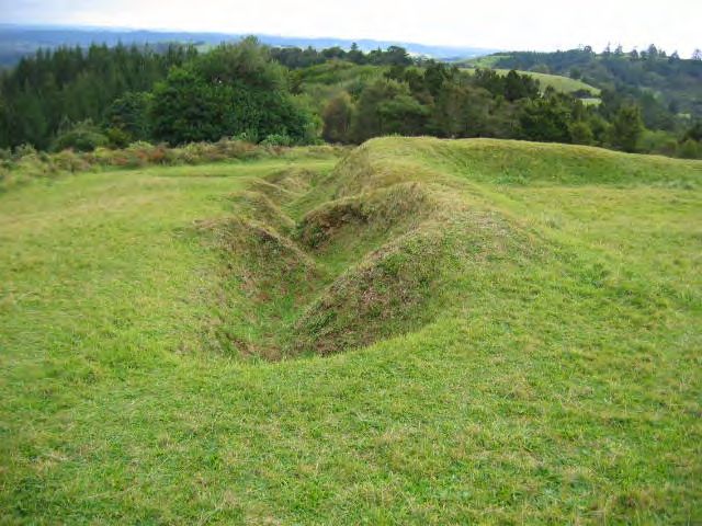
India Company. 26 Tamati Waka Nene bought along about 400 Ngapuhi warriors. 27 In
contrast, the defenders of the pa numbered only 300 to 400. 28

The British assembled an impressive arsenal: three 32-pounders, one eighteen-pounder,
two twelve-pounders, and assorted lighter pieces including mortars. It took three weeks
to get everybody up to the site of the battle:

      Taking the guns up to Ruapekapeka, was a feat not accomplished without difficulty
      and hard work, the landing and getting the thirty-two pounders up a perpendicular
      hill being in itself quite an undertaking. They were afterwards moved fourteen
      miles over the most hilly county it has ever been my fate to travel, without a particle
      of road, and passing thorough a dense wood. 29

Just before Christmas the British began to arrive at Ruapekapeka. They set up camp
and established three firing positions. The first was at the main camp, housing one of
the 32-pounders and two smaller guns. The second battery, which housed two of the 32-
pounders and four mortars, was about 400 yards from the pa and a stockade was built to
defend it. 30 The third battery was in a more advanced position, covering the right flank
of the pa. The British begun to fire upon the pa from their arrival, but it took some days
to get all of the guns into position. On 10 January the work was complete, and Despard
ordered all of the guns and rockets to open fire at once. The outer defences, robust as
they were, could not withstand prolonged and concerted attention from the British
cannons. By the end of the day the British could see a considerable breach in the
defences. 31

On Sunday 11 January the British stormed the breach, but only after scouts had
determined the pa was all-but-deserted. Kawiti’s troops were in the area behind the pa,
accompanied by Heke and his men who had only just arrived. An oft-repeated
explanation has them resting or at prayer (in contrast with the impiety of the attacking
forces). Historian James Belich dismisses the Sunday prayers story. 32 He argues that
Heke and Kawiti intended to lure the attackers through the pa and into an ambush in
the forest behind. Ralph Johnson offers a different explanation: that the pa was in the
process of being evacuated when the British entered, and that the firing positions in the
forest were for protecting the rear of the party during the withdrawal 33 .

26
   J. Belich. 1988. p. 59.
27
   See R. Johnson 1996. p. 362.
28
   R. Johnson 1996. p. 362.
29
   H. F. McKillop. 1849. Reminiscences of twelve months’ services in New Zealand.
30
   Col. Despard’s despatch. 5 Jan 1846.
31
   Diary of Major Cyp. Bridge, 10 January 1846.
32
   James Belich. 1988. p. 62-64.
33
   R. Johnson. 1996. p. 376.

                                                                                          7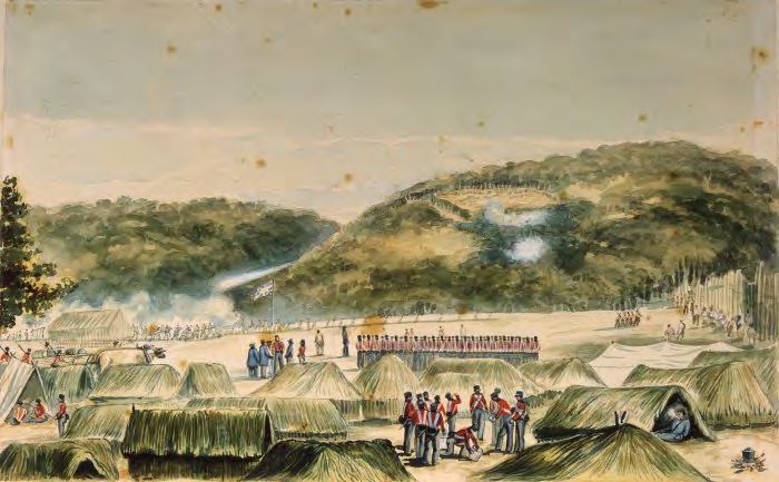
Figure 4: View from the main camp looking towards the pa during the bombardment. [John
Williams, Ruapekapeka. N.Z. January 1846. Watercolour. Alexander Turnbull Library A-070-
030].

Once the attackers were inside the pa, a good number of soldiers and sailors were
unable to resist the urge to rush into the forest. 34 This is where the British suffered
most of their causalities: 12 killed and 29 wounded. An account is presented in
Manning (1862):

      Most of the soldiers remained in the pa firing through loop-holes … A few sailors
      and soldiers, however, went out a little gate at the back of the pa, but were no
      sooner out than they were shot by the people behind the trees. At least some forty
      or fifty soldiers got out, and a fight began outside. 35

After a number of soldiers were killed in the bush, the British pulled back into the
relative safety of the pa. The defenders withdrew to the south, split into smaller groups
and headed to different destinations. 36 Despard lost no time in announcing a great
victory in his dispatches.

Historians have since expended a lot of energy analysing the causes, debating the
course of events, and dissecting the British claim of victory. Ralph Johnson offers a
concise summary:

      The governor amassed a large military force of over one thousand soldiers and
      sailors and attacked Kawiti on a scale not previously seen. Ruapekapeka pa was
      bombarded with a heavy rain of artillery, which inflicted significant casualties
      among the defenders and eventually drove Kawiti and his followers from their pa.
      Although historians have debated how the pa was gained, and the veracity of the
      British claims of victory, the fact remained that Kawiti had been forced from his pa

34
   Diary of Major Cyp. Bridge.
35
   Manings, F. E. 1862. p. 43.
36
   R. Johnson. 1996. p. 374.

                                                                                       8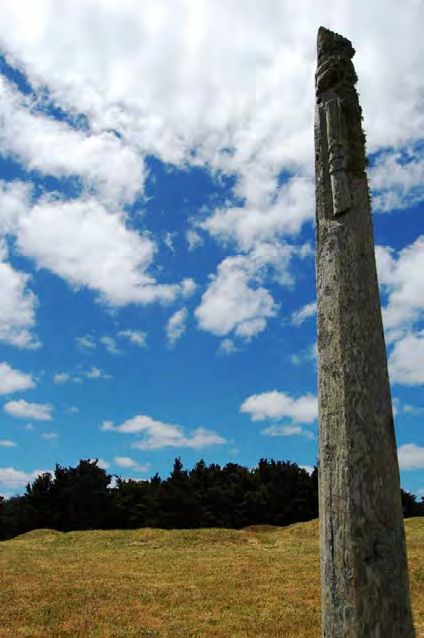
and suffered losses. Ruapekapeka was the scene of a heavy British military assault
      against chiefs who had asked for peace and sought only to maintain chiefly
      authority and their lands both guaranteed to them under the Treaty of Waitangi. 37

Fabric
The Ruapekapeka Historic Reserve encompasses the pa itself, the main British battery,
and part of the British camp. The British troops did an incomplete job of destroying the
pa in 1846. Some of the palisades were still standing in 1899, and cannon balls were
lying about the place. 38 In 1939 James Cowan was able to enter one of the subterranean
shelters, and in 1951 the puriri slabs over the dugouts were intact. 39 It is no longer
possible to enter any of the bomb-proof shelters or connecting tunnels, although some
of the tunnel entrances are visible (see figure 7).

Figure 5: Oblique aerial view of the pa site. The rear of the pa is at the left; the outer defences
were breached at the lower right corner.

The earthworks of the outer defences are largely intact aside from the northern corner
(see archaeological plan in appendix B). The firing trench around the perimeter is
particularly impressive. Visiting the site, it is easy to understand the defensive
principles; you can see how the design allowed a flanking fire to be directed at the
enemy, and how the rifle trenches prevented a similar tactic being used against the
defenders. Plans of Ruapekapeka drawn shortly after the battle show that the pa had
two wells. One of these, just on the outside of the defences, remains open today with a
fence around it for safety reasons.

37
   R. Johnson. 1996. p. 387.
38
   Auckland Weekly News, March 3 1899
39
   See source quoted in J. Gardiner, 1983.

                                                                                                9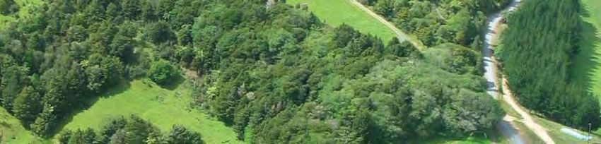
There is an 18-pounder carronade 40 mounted near the centre of the pa.          This is
apparently one of the two pieces of artillery Kawiti had in his possession during the
battle. 41 Until a recent re-assembly project, the carronade was broken apart, possibly
after being hit by a cannon ball during the bombardment. 42

Figure 6: A view of the outer defences, showing the rifle trench partially divided with earthen
banks, and an embankment on the interior side.

The remains of the main British firing position are shown in appendices A and B. The
earthworks show that the stockade was pentagonal in shape with two platforms on the
edge facing the pa. The 32-pounders were mounted on these platforms.

The British camp is located on a flat area about 300 metres north-west of the main firing
position. There is not much to see from the surface, except for a possible ditch.
However, there are archaeological features below the surface, confirmed by the results
of a geophysical survey carried out in 2005. The features were interpreted as drains
around a group of tents, a row of palisades, and part of the original road connecting to
the advanced firing position. 43 The survey revealed that the site of the main camp
extends beyond the boundaries of the historic reserve.

40
   A carronade is a short-barrelled cast iron navy cannon
41
   T. Kawiti. 1956. p. 42.
42
   T. Kawiti. 1956. p. 42 states that the carronade was “rendered useless” due to a direct hit. An
article in the Auckland Weekly News in 1899 states that “some settlers’ sons went the other day
and put a charge of dynamite to it, bursting it into two halves.”
43
   Geometria. 2006. Ruapekapeka Pa Historic Reserve: Report of Geophysical and Topographical
Surveys. Report prepared for the Department of Conservation.

                                                                                              10
Figure 7: An entrance to a tunnel within the pa.
Cultural Connections
Multiple iwi and hapu have strong connections to Ruapekapeka, as tangata whenua of
the area, participants in the battle of 1845/6, or both. These include Ngati Manu, Ngati
Kahukuri (Ngati Hau), Ngati Hine, Te Kapotai and Ngapuhi Nui Tonu. 44
Significance
Ruapekapeka is one of the most significant historic sites in New Zealand, recognised by
its status as one of the Departments’ ICON sites. Ruapekapeka certainly meets the
criteria to be registered as Category I Historic Place under the Historic Places Act. That
it has not been registered is because of a perceived lack of urgency/need owing to its
Historic Reserve status.
History Significance
The Northern War is a singularly important event. Although sometimes viewed as
a limited series of battles, it represents the earliest and clearest example of the
forcible imposition of British colonial power (kawanatanga) over Ngapuhi chiefly
authority (tino rangatiratanga). 45
The history of Ruapekapeaka is entwined with that of the Treaty of Waitangi, a living
document which continues to shape New Zealand society. The very existence of the
Ruapekapeka site counteracts a powerful myth; the idea of racial harmony, that Maori
44
These are the iwi/hapu represented on the Ruapekapeka Pa Management Trust, according to
the Deed of Trust.
45
R. Johnson. 1996: 12
11and Pakeha were miraculously joined as one after the signing of the Treaty of
Waitangi. 46 The fighting in the north was a reaction against that founding document.
The fight continues, although the arena has shifted from battlefield to courtroom. In the
words of R. J. Walker, the War of the North was “a portent of the Maori dynamic of self-
determination that was to find expression in various movements of the next 140
years.” 47
Culture Significance
To iwi, the Battle of Ruapekapeka is not consigned to a distant past. It is a recent event,
the stories told and remembered by successive generations. The underlying causes of
the battle – issues of mana, land, power, and Te Tiriti – have yet to be addressed. Kawiti
and Heke may not have lost the series of battles which we call the War of the North. 48
However, Ngapuhi certainly did loose the bigger struggle to exercise their own chiefly
authority in accordance with Te Tiriti. 49
Figure 8: The pouwhenua erected on the pa
by descendents of Te Ruki Kawiti.
46
J. Belich. 1986.
47
R. J. Walker. 1984. The Genesis of Maori Activism. Journal of the Polynesian Society 93:267-
282.
48
See J. Belich. 1998.
49
Johnson. R. 1996. 413.
12Fabric Significance
Ruapekapeka is the best preserved of all the New Zealand Wars’ sites, and is the only
battlefield of the Northern War where surface features remain. The story of
Ruapekapeka is unique, but at the same time it is a wonderful example of a “gun-fighter”
pa, show-casing the Maori response to muskets and heavy artillery. In 2008 the
Institution of Professional Engineers of New Zealand (IPENZ) acknowledged the
ingenious design of the pa, by way of a bronze plaque installed at the site. The intact
fabric – including the pa itself, the advanced British position, and the subsurface
remains at the main British camp must be ascribed a high degree of significance.
Management Chronology
A summary of the management history of Ruapekapeka pa and battle field can be found
in a report prepared by David Armstrong and others. 50
Early interest in the site of the battle was focussed upon the graves of the fallen soldiers
and sailors. The issue was raised in parliament in 1884 by Mr Hakuene, M.P. for
Northern Maori, who suggested fencing the burial ground to prevent its desecration. 51
Unfortunately, the graves were never fenced and their location has since been forgotten.
In 1889, the pa was in a “fair” state of preservation, although some of the earthworks had
been damaged by cattle. During the decades that followed, local settlers filled in some
of the earthworks, which were a hazard to wandering cattle. Fires and ploughing caused
further damage, and it was apparent that the pa was heading towards obliteration. The
Bay of Islands County Council and certain Members of Parliament began to advocate
for its acquisition and preservation 52 .
In 1914, just over 5 acres (the pa itself) became a scenic and historic reserve under the
Scenery Preservation Act. 53 The Maori owners stipulated that the pa site must be
fenced, cleared of scrub, and kept in good order, and £13 compensation was paid to
them. 54 According to Armstrong et al, that Maori agreed to the alienation of the pa is
evidence of their deep concern for its preservation and maintenance, a time-consuming
and costly exercise.
In the 1920s Ruapekapeka was cleared of vegetation, sewn in pasture, and fenced. A
great number of visitors were attracted to the site; however the well-maintained state
did not last, in part due to lack of on-going funding. In the absence of grazing, weeds
and ferns grew to obscure the earthworks. 55 The vegetation was cleared again in the
late 1930s, but again it was not maintained. 56 The New Zealand Historic Places Trust –
who managed the site from the late 1960s – undertook planning and research, but
achievements on the ground were modest. 57 Archaeologist J. Coster summarised the
50
D. Armstrong, W. O’Malley & B. Stirling. 2008. Northland Land, Culture and Education. Part
Two: Wahi Tapu, Taonga and Te Reo Maori. A Report Commissioned for the Crown Forestry
Rental Trust, p. 272-287.
51
See J. Gardiner. 1983.
52
D. Armstrong et al. 2008, p. 273.
53
D. Armstrong et al. 2008, p. 273.
54
D. Armsrtong et al. 2008, p. 277.
55
D. Armstrong et al. 2008, p. 283.
56
D. Armstrong et al. 2008, p. 284.
57
D. Armstrong et al. 2008, p. 285.
13situation: “The management history of Ruapekapeka up to the mid 1960s was one of not
particularly benign neglect.” 58
In more recent years, the management of Ruapekapeka has been in the hands of the
Department of Lands and Survey, succeeded by the Department of Conservation. The
Ruapekapeka Pa Management Trust (RPMT) was formed in 1994, to represent the
iwi/hapu who defended Ruapekapeka in 1845/6.
The development of Ruapekapeka as a visitor site began in earnest in 2003. A
Development Plan was commissioned, and walking tracks, a new car park, and
interpretation signs were developed. A waharoa (carved gateway) was installed near
the entrance to the pa. Many native seedlings have been planted since the
redevelopment, and the planting programme continues to date. A regular mowing and
vegetation maintenance programme in place.
1914 Ruapekapeka Gazetted as a reserve. 59
1922 £200 granted for fencing, clearing, and emptying of rifle pits. 60 .
1930s – 1960s Site neglected and overgrown with fern and blackberry. 61
1967 Proposal to develop the pa for tourists; artefacts and palisades
removed for safekeeping, pa fenced off and stock removed, additional
land for parking and recreational purposes acquired, however
progress stalled.
1971 Collection of artefacts associated with the battle, held by Mr B.
Timperly, gifted to the Crown. These items include parts of puriri
palisades, a collection of cannon balls and rocket fragments, and part
of the barrel of a cannon. 62
1973 Pa site and advanced British position gazetted as a Historic Reserve.63
1979 The two reserves united by the purchase of the piece of land in
between.
1980 Bay of Island Maritime and Historic Park assumes control.
1983 Extensive research carried out to prepare management plan proposal.
1980s Trial plantings of Metrosideros (creeping rata) begin, to prevent
further erosion of archaeological features
1987 Department of Conservation created; assumes control of
Ruapekapeka Historic Reserve.
1994 Ruapekapeka Pa Management Trust established after a series of hui.
Trustees elected to manage Ruapekapeka in conjunction with the
Department of Conservation.
1998 Land containing part of the Main British Camp purchased and added
to the Historic Reserve.
2003 Tracks and new car park completed, interpretation signs and waharoa
installed.
58
J. Coster. 1985. Ruapekapeka Management Requirements. Internal Department of
Conservation File NP253.
59
J. Gardiner. 1983, p. 10
60
E. C. Clarke. Letter to the Commissioner of Crown Lands. 9 August 1938. Internal Department
of Conservation File NP 253.
61
J. Gardiner. 1983, p. 11.
62
Internal Department of Conservation File N.P. 253. These items are currently held at the
Whangarei Museum.
63
New Zealand Gazette 1973 p. 894.
142003-present Ruapekapeka maintained as a visitor site by the Department of
Conservation, and managed in conjunction with the Ruapekapeka Pa
Management Trust.
Management Recommendations
Vegetation control
Ensure mowing/scrub-barring of archaeological features is continued, and carried out
to the highest standard. At present the Main British Camp is grazed, subject to certain
conditions designed to protect the sub-surface archaeological features. At present,
grazing is the best option for this undeveloped part of the reserve.
Pest control
There is evidence of significant damage caused by rabbits on the pa and at the
advanced British position. Options for rabbit control should be pursued. Plant pests
on the pa include bracken fern, blackberry, and gorse. Spot spraying of these species
should be carried out as required.
Erosion
Erosion of the archaeological features is an on-going problem. Planting creeping rata
has been successful to a certain degree, and more seedlings should be planted as
needed.
Maintaining visitor facilities
Ensure tracks continue to be maintained. Repair or replace damaged interpretation
signs as required.
Amenity planting
Continue to plant seedlings to areas identified in appendix C. New plantings should not
encroach upon existing lawn area. It is preferable to focus upon filling in the gaps in
areas already planted, particularly in zones three, five, six and seven (see appendix D).
NB: flax should not be planted within two metres of any track or lawn area, as it creates
a maintenance problem when the plant matures.
Future development
The future direction of the site depends upon several factors. Management decisions
are made by the Department together with the RPMT. In the short-to-mid term,
attention will focus upon using technology to deliver new and exciting interpretation.
The RPMT is in the process of preparing a plan which outlines their strategic direction
for the Ruapekapeka Pa and battlefield site.
Conclusions
The Department assesses historic heritage value against three broad criteria: history
significance, fabric significance, and cultural significance. By all three criteria, the
historic heritage values of Ruapekapeka are extremely high. In its wider historical
context, it is connected to events which shaped a nation. It is the only Northern Wars’
battle site with features visible on the surface, and it is better preserved than any pa of
the “Land Wars” of the 1860s.
15The story of Ruapekapeka is embedded in the psyche of Northland Maori. The site,
however, is part of a history shared by all New Zealanders. It is no longer a battle field;
it is a place to visit and reflect, to admire the design of the earthworks, and to appreciate
the journey we’ve travelled since 1846. The pou whenua in the middle of the pa is a
subtle reminder that we have yet to reach our destination.
16Bibliography
Published
Belich, J. 1988. The New Zealand Wars. Penguin Books.
Burrows, R. 1888. Extracts for a Diary Kept by the Rev. R. Burrows during Heke’s War in
the North.. Facsimile Edition published in 1998, Kiwi Publishers, Christchurch.
Carleton, Hugh. 1874. The Life of Henry Williams, Archdeacon of Waimate (vol. 2).
Available at www.enzb.auckland.ac.nz
Cowan, James. 1922. The New Zealand Wars and the Pioneering Period (vol. 1). W.A.G.
Skinner, Government Printer. Wellington.
Kawiti, Tawai. Heke’s War in the North. 1956 (October). Te Ao Hou 16:38-46. Available
at teaohou.natlib.natlib.govt.nz
Maning, F. E 1862 (?). History of the War in the North of New Zealand against the Chief
Heke in the year 1845. Told by an old chief of the Ngapuhi Tribe. Reprinted 1999.
McKillop, Lieut. H. F. 1849. Reminiscences of twelve months’ services in New Zealand (as
a midshipman during the late disturbances in that colony). Available at
www.enzb.auckland.ac.nz
Walker, R. J. 1984. The Genesis of Maori Activism. Journal of the Polynesian Society
93:267-282.
Newspaper
Auckland Weekly News, 3 March 1899
The New Zealander, Saturday 21 January 1846.
Unpublished
Armstrong, D., V. O’Malley & B. Stirling. 2008. Northland Language, Culture and
Education. Part Two: Wahi Tapu, Ttaonga and Te Reo Maori. A report commissioned by
the Crown Forestry Rental Trust.
Bridge, Major Cyprian. Journal of Events on Expedition to New Zealand Commencing
4th April, 1845. Unpublished manuscript. Typescript copy held at Whangarei Central
Library.
Gardiner, John. 1983. Ruapekapeka Pa Historic Reserve: Management Plan Proposal.
Report prepared for the Bay of Island Maritime and Historic Park Board.
Geometria. 2006. Ruapekapeka Pa Historic Reserve: Report of Geophysical and
Topographical Surveys. Report prepared for the Department of Conservation.
Johnson, R. 1996. The Northern War 1844-1846. An Overview Report Commissioned by
the Crown Forestry Rental Trust.
17Ruapekapeka Pa and Battlefield: A Development Plan. 2003. Unpublished Report
prepared for the Department of Conservation and the Ruapekapeka Pa Management
Trust.
Department of Conservation Files
Internal Department of Conservation File N.P. 253. Held at Whangarei Area Office.
Evaluation of Sources
There is a wealth of source material available for the Battle of Ruapekapeka. Primary
sources include correspondence and despatches of Colonel Despard and Governor
George Grey, and the diaries of Cyprian Bridge, Alexander Whisker, and Henry
McKillop. A collection of paintings, sketches, maps and plans of the pa and battlefield
were produced during and immediately after the battle.
The body of primary source material reflects the battle from the point of view of the
British. The problem is that there is no publically available source material from a Maori
point of view. The perspective from inside the pa is remembered as oral histories,
passed down through the generations. Some of these oral histories have been recorded,
but are not available to researchers without express permission from individual
kaikorero 64 . The lack of published/available information increases the importance of a
two secondary sources which draw upon Maori accounts of the battle (Kawiti 1956 and
Johnson 2006). The Johnson report, prepared for the Waitangi Tribunal process, is
400 pages long and provides a thorough and balanced overview of the War of the North.
Other important secondary sources include Manning (1862), Cowan (1922) and Belich
(1986). A list of source material for the Battle of Ruapekapeka is held at the Whangarei
Area Office; further references may be found in the bibliography of the Johnson report.
Numerous files held at the Whangarei Area Office generally relate to the management
of Ruapekapeka Historic Reserve.
64
speaker, narrator
18Appendix A
Oblique Aerial Photograph of Ruapekapeka Historic Reserve
Main British battery is in the foreground (mown area); pa in background, corners
indicated by arrows. The cannons were aimed at the bottom left corner of the pa, and
this is where the breach occurred.
19Appendix B: Archaeological Plan of Ruapekapeka Pa and the British
Position (drawn by J. Leatherby and P. Morgan)
20Appendix C: Contemporary maps and plans
Compiled from sketches by Capt. Marlow and others
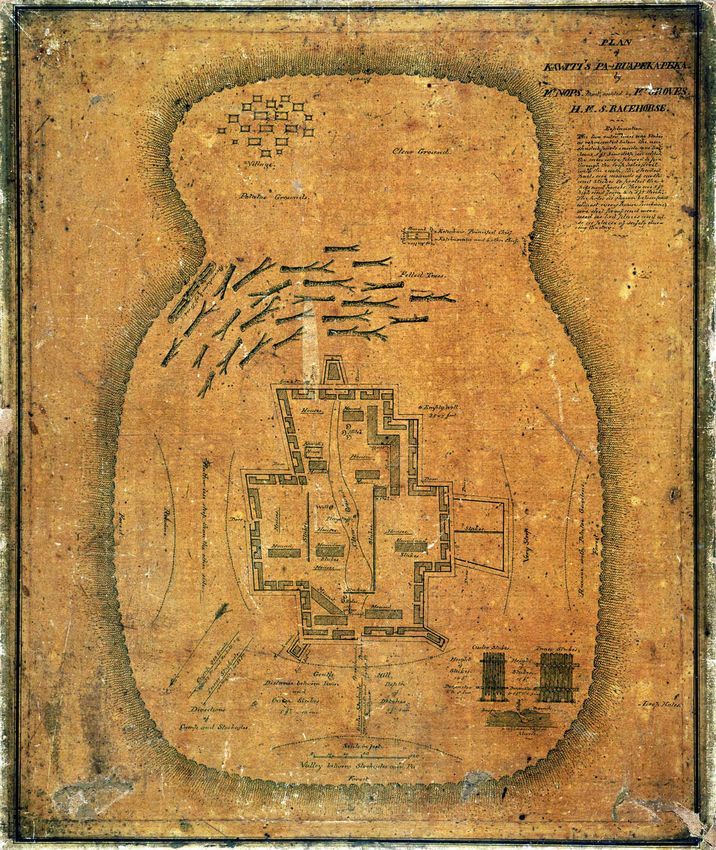
21Plan of Kawiti's Pa at Ruapekpeka by Mr Nops, assisted by Mr Groves, H.M.S.
Racehorse
22Appendix D: Diagram showing planted areas (established forest shown in green; recent plantings in pink)
You can also read