High nature value farmlands: challenges in identification and interpretation using Cyprus as a case study - Nature Conservation
←
→
Page content transcription
If your browser does not render page correctly, please read the page content below

A peer-reviewed open-access journal
Nature Conservation 31: 53–70 (2018)
                High Nature Value farmlands: challenges in identification and interpretation...                                                      53
doi: 10.3897/natureconservation.31.28397                 RESEARCH ARTICLE
http://natureconservation.pensoft.net                                                                    Launched to accelerate biodiversity conservation

High nature value farmlands: challenges in identification
    and interpretation using Cyprus as a case study

               Maria Zomeni1, Angeliki F. Martinou2, Menelaos C. Stavrinides2,
                                 Ioannis N. Vogiatzakis1

1 School of Pure and Applied Sciences, Open University of Cyprus, Cyprus 2 Department of Agricultural Scien-
ces, Cyprus University of Technology, Cyprus

Corresponding author: I.N. Vogiatzakis (ioannis.vogiatzakis@ouc.ac.cy)

Academic editor: Joseph Tzanopoulos | Received 17 July 2018 | Accepted 24 October 2018 | Published 21 December 2018

                                  http://zoobank.org/1F989F72-3EB8-432C-8455-35CF879F0A3C

Citation: Zomeni M, Martinou AF, Stavrinides MC, Vogiatzakis IN (2018) High Nature Value farmlands: challenges in
identification and interpretation using Cyprus as a case study. Nature Conservation 31: 53–70. https://doi.org/10.3897/
natureconservation.31.28397

Abstract
High Nature Value Farmland systems (HNVf ) in Europe are recognised for their importance for biodiver-
sity conservation and their extent is one of the impact indicators in the CAP monitoring and evaluation
framework for the 2014–2020 cycle. Due to differences in farming typologies and data availability between
nations, a common methodology for identifying HNVf does not exist, nor is considered appropriate. In
the current study we use the Mediterranean island of Cyprus as a case study to highlight EU-wide issues
for the identification and mapping of HNVf. We brought together under a common spatial framework
datasets on farming typology, agro-chemical inputs, water use intensity and biodiversity data collected from
public authorities and nature/biodiversity conservation organisations. Using an expert driven approach
informed by a range of stakeholders, we identified and mapped potential HNVf areas employing a 1 km2
mapping grid as the reporting spatial framework under two storylines for defining farmland area within
every grid cell: a liberal with 10% threshold and a conservative with 25% threshold. Areas containing po-
tentially HNVf may extend from 22.5–34.5% of the island, depending on the storyline employed. HNVf
Type I is the more restricted type for both storylines, while Type II is the most extensive. The highest over-
lap was between Type II and Type III for the liberal storyline and between Type I and II for the conservative
storyline. HNVfs cover an area between 30 to 57% of the Natura2000 network on the island depending on
the storyline. With the liberal storyline for farmland definition, the spatial extent of HNVfs together with
the existing Natura2000 sites cover 90% of the study area, while with the conservative storyline this figure
drops to ca.75%. The results confirm the role of HNVfs within and around Natura2000 sites in Cyprus
and their potential for providing connection and site buffering opportunities, particularly in the lowlands,
while they can provide information about policy-making for agri-environmental payments targeting.

Copyright Maria Zomeni et al. This is an open access article distributed under the terms of the Creative Commons Attribution License (CC
BY 4.0), which permits unrestricted use, distribution, and reproduction in any medium, provided the original author and source are credited.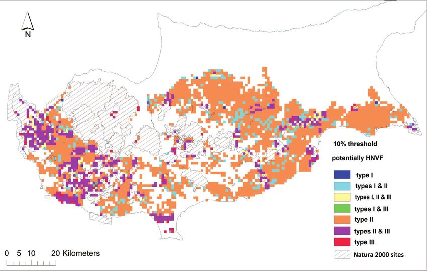
54                   Maria Zomeni et al. / Nature Conservation 31: 53–70 (2018)

Keywords
biodiversity, conservation, Mediterranean island, Natura2000, policy-making

Introduction
Many environmental threats, including climate change, biodiversity loss and degrada-
tion of land and freshwater are attributed to unsustainable agricultural practices (Foley
et al. 2011). Agricultural intensification worldwide has had tremendous impacts on
habitats, biodiversity and ecosystem functions and services (Zhang et al. 2007, Power
2010, Foley et al. 2011). The success of key environmental policy and legislation re-
lated to climate change targets (e.g. Roadmap to 2050) and meeting the 2020 biodi-
versity targets are heavily dependent on agricultural activities. In fact, Target 3 of the
EU 2020 Biodiversity Strategy states explicitly that, by 2020, measures must be taken
to “bring about a measurable improvement in the conservation status of species and
habitats that depend on or are affected by agriculture and in the provision of ecosystem
services as compared to the EU2010 Baseline” (http://www.alter-net.info/).
     Agroecosystems are often considered incompatible with conservation and pro-
tection. However, in Europe the growing recognition that biodiversity conservation
depends on the persistence of low-intensity farming systems catalysed the formation
of the concept of High Nature Value farmland (HNVf ) (Beaufoy and Jones 2012).
HNVfs are parcels of farmland that are expected to support high levels of biodiversity
or species and habitats of conservation concern because of certain features. HNVfs are
classified into three categories, depending on the presence of semi-natural vegetation in
the farmland, the diversity of low input farmland and the presence of species of conser-
vation concern (Table 1) (Paracchini et al. 2008; Beaufoy and Jones 2012).
     HNVfs are present all over Europe and include semi-natural pastures and hay
meadows in Western Europe, Ireland and the UK and traditional cropping and orchard
systems where livestock activities can also be present, such as olive groves, vineyards and
cork oaks in the Mediterranean (Oppermann et al. 2012; Keenleyside et al. 2014). The
largest extent of HNV farmland is found in Southern Europe with Spain having the
highest percentage of HNVfs with respect to its utilised agricultural area (Keenleyside et
al. 2014). HNVfs offer a great range of ecosystem services in addition to food provision,
such as maintenance of crop genetic diversity, biocontrol services, erosion control, pol-
lination and recreation services, while at the same time, they support rural livelihoods
in remote areas (Keenleyside et al. 2014). HNVf landscapes are important for their eco-
logical, cultural and socio-economic role. Some systems, such as the dehesas or monta-
dos in Spain and Portugal or the vineyards producing the sweet wine Commandaria on
the south-western foothills of Cyprus, are historic landscapes. HNVfs have the poten-
tial to offer economic benefits and sustain rural populations as well as create benefits for
the agrotourism industry and the wider public (O’Rourke et al. 2016).
     The percentage of HNVf relative to the total utilised agricultural area (UAA) is ac-
knowledged as an important indicator for monitoring landscape changes at spatial and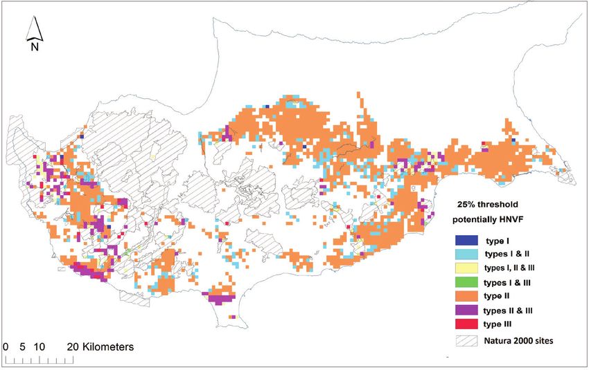
High Nature Value farmlands: challenges in identification and interpretation...   55

temporal scales, as it is sensitive to anthropogenic impacts and it can be easily commu-
nicated in a policy-relevant context. The identification of HNVf in EU member states
(MS) and monitoring its extent and condition is a policy instrument for agriculture and
nature conservation purposes. HNVf is one of the 32 agri-environmental indicators de-
veloped by Eurostat to monitor the effects of agriculture on the environment and one of
the impact indicators in the Common Monitoring and Evaluation Framework of CAP
(http://epp.eurostat.ec.europa.eu/). At the same time, it is also a series of practical meas-
ures for biodiversity conservation (i.e. as habitats) and for providing valuable connections
in the landscape for species movement (Doxa et al. 2012; Sutherland et al. 2010). For
instance, vineyards and carob groves in Cyprus, provide feeding and breeding grounds
to a diverse range of organisms, including many species listed in the Birds and Habitats
Directives, such as the endemic birds, Cyprus warbler (Sylvia melanothorax) and Cyprus
wheateater (Oenanthe cypriaca), as well as raptors, including the kestrel (Falco tinunculus)
and the long-legged buzzard (Buteo rufinus). Along with bird species, many key insect
species such as the critically endangered beetle Propomacrus cypriacus and a diverse range
of pollinators, reside in agricultural fields and their margins (Sparrow and John 2016).
     Regrettably, HNVf systems are currently threatened by two major opposing forces, in-
tensification on the one hand (e.g. high inputs of pesticides or overgrazing) and land aban-
donment on the other. On the Mediterranean island of Cyprus, both forces have been
acting simultaneously on the landscape for the last 50 years. The Utilized Agricultural Area
(UAA) has seen a dramatic decline (Cyprus Statistical Service 2012) with extensive cereal
crops and vineyards experiencing the largest decline. Intensification and land abandon-
ment stem from the farmers’ need to increase their income which is usually a response to
political and economic imperatives. Especially in marginal areas, a farmer’s profit can be
discouragingly low for managing the land in a traditional, sustainable manner. The current
challenge is to identify and apply strategies which will maintain the ecological benefits and
create further socioeconomic turnover for the stewards of the HNV farming land across
Europe. An essential first step towards this goal is defining what constitutes an HNVf
system, describing its particular features and mapping HNVf land for each EU MS.
     The methodology proposed by Andersen et al. (2003), revised by Paracchini et
al. (2006), provides a European HNVf map which is not sufficiently accurate for ap-
plications at national and regional levels. Therefore MS are advised to use this indica-
tive method (Beaufoy and Cooper 2008) and apply at national level, by adapting it
to their specific conditions and contexts (EEA 2016). To this end, there have been
various attempts to HNVf mapping (Hazeu et al. 2014; Halada et al. 2011; Galdenzi
et al. 2012). In the case of Types I and II, two complementary approaches have been
employed. The first is based on the use of land cover maps, which is suited for the
localisation of HNV farmland areas. The second is the farm system typology, which
combines agronomic and economic data derived from farms (e.g. FADN). The meth-
odology employed at various national attempts follows or relies principally on the one
proposed at the European level by Paracchini et al. (2006). Most attempts at national
level use coarse data and therefore only approximate the spatial location of HNVfs. In
a paper by Lomba et al. (2014), the caveats associated with the identification, mapping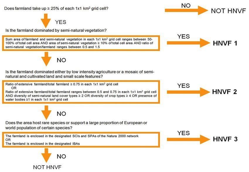
56                Maria Zomeni et al. / Nature Conservation 31: 53–70 (2018)

and monitoring of HNVfs in Europe are discussed, many of which stem from the very
definition and concepts associated with HNVfs. The various attempts so far demon-
strate that the methodology proposed is ‘confusing’ and is interpreted in different ways
when applied (Lomba et al. 2014; Lomba et al. 2015).
     Agriculture in Cyprus is characterised by a mosaic pattern of small plots with a
diversity of permanent and arable crops. Two thirds of the farms in Cyprus are less than
20 ha in size (FSS 2007) while extensive farmlands with olives, carobs and vineyards
have resulted in a diversity of cultural landscapes (Vogiatzakis and Manolaki 2017).
This in turn provides an invaluable habitat to a rich biodiversity and, in particular, avi-
fauna found within and around Natura2000 sites (Hellicar 2012). Yet and despite their
importance for natural and cultural heritage, to date the extent of these High Nature
Value farmlands on the island has not been sufficiently mapped. Therefore the objec-
tives of the paper are to a) characterise and map HNVfs in Cyprus, adapting where
necessary existing methodologies and b) identify potential synergies of HNVfs and the
current spatial configuration of Natura 2000 areas.

Methodology
Study area

Cyprus is the third-largest Mediterranean island and a biodiversity hot-spot with high
levels of endemism (Tsintides et al. 2007). Agricultural fields cover ca. 50% of the land
surface of the island in which the Government of the Republic of Cyprus exercises full
control (CYGCA). Mapping was confined to these areas (CYGCA) since there were
no data available for the northern part of the island.-In the last 40 years, the Utilized
Agricultural Area (UAA) of Cyprus has seen a dramatic decline, from approximately
180,000 ha in 1975 to 115,000 in 2012 (Cyprus Statistical Service 2012). The largest
acreage decrease was observed for cereals and vines, two extensive crops, which could
potentially meet the definition of HNVf. Cereal crops (mostly rain-fed barley) de-
creased from a maximum of 73,000 ha in 2003 to 38,000 ha in 2012, while vineyards
dropped from a maximum of 35,000 ha in 1975 to 7,000 ha in 2012. Carob groves,
another extensive crop and an important feature of the island’s landscapes, have also
seen a dramatic reduction from 7,000 ha in 1985 (earliest available data) to 1,700 ha in
2012. Approximately 10% of the UAA of Cyprus is used for growing intensive crops,
mainly vegetables, potatoes, citrus and other fruits.

Datasets and mapping process
Mapping of HNVfs usually relies on four sets of indicators (Lomba et al. 2014): land-
scape elements, extensive practices, crop diversity and indicator species. We followed
a similar approach and employed high resolution data with experts’ opinion and fine-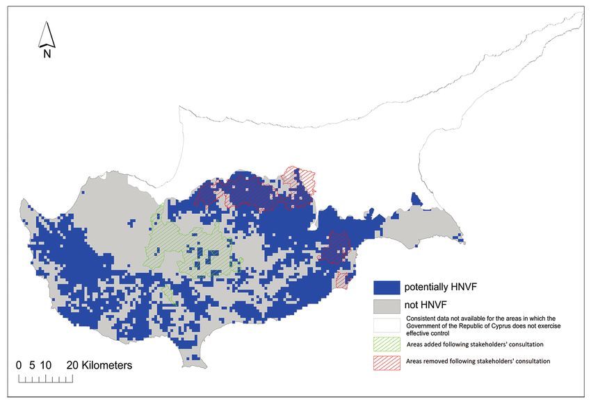
High Nature Value farmlands: challenges in identification and interpretation...             57

Figure 1. Selection rules for mapping the three types of potentially HNVfs in Cyprus using the conserva-
tive storyline (25% threshold). The liberal storyline was applied with identical rules with the exception of
the 10% threshold for % farmland within every 1 km2 grid cell.

tuning according to ground-truthing and local conditions. High resolution spatial data
from the land parcel information system (LPIS) for 2013 (the latest available dataset),
containing the delimited plots at national level, were combined with farm system data
from the Cyprus Agricultural Payments Organization (CAPO). The CAPO dataset
provides information on the type of farm and type of crops cultivated on each plot,
including grasslands. Plots, including non-claimed farmland (no financial support re-
quested), were excluded from the analysis, since such farmland was not eligible for
payment under CAPO and there is no reporting on crop types or on whether they are
active or abandoned. This information along with datasets on farming typology rules,
agro-chemical inputs, water use intensity, Natura2000 sites, water bodies and Impor-
tant Bird Areas (IBAs) were collated in a common spatial framework.
     These data were complemented with CORINE Land Cover 2012 data (1:250,000)
for the distribution of semi-natural vegetation. Seventeen CORINE level three types
were used, namely the categories: 3.1.1, 3.1.2, 3.1.3, 3.2.1, 3.2.2, 3.2.3, 3.2.4, 3.3.1,
3.3.2, 3.3.3, 3.3.4, 4.1.1., 4.2.1, 4.2.2, 4.2.3, 5.1.2, 5.2.2. CORINE land cover data
provided the best proxy information on the distribution pattern of semi-natural veg-
etation, since national data at similar or finer scales do not include all semi-natural
categories and were produced with different schemes and for different purpose (e.g. the
state forests map of the island).
58 Maria Zomeni et al. / Nature Conservation 31: 53–70 (2018)
Table 1. HNVf definitions and mapping: A comparison between JRC’s approach (Paracchini et al. 2008)
and this study.
Definitions JRC’s approach Approach employed herein
Type I: Farmland with a high proportion of semi- Field parcels for cropland; CLC for semi-
CLC cover types
natural vegetation. natural vegetation; Validation by stakeholders
Type II: Farmland with a mosaic of low intensity
CLC cover types; Field parcels for cropland; CLC for semi-
agriculture and natural and structural elements, such
Areas suggested by natural vegetation; Other mapped natural and
as field margins, hedgerows, stone walls, patches of
stakeholders structural elements; Validation by stakeholders
woodland or scrub, small rivers etc.
Field parcels for cropland; CLC for semi-
Type III: Farmland supporting rare species or a high CLC cover types;
natural vegetation; IBAs; Validation by
proportion of European or World populations. IBAs
stakeholders
The spatial datasets were evaluated for the definition and mapping of HNVfs in
Cyprus by combining the specific selection rules applied by JRC for Cyprus (Paracchini
et al. 2008; Table 1) with principles of landscape ecology and field work (Fig. 1). A 1
km2 grid was overlaid on the study area and two scenarios were used for delineating po-
tential areas with HNVf within each grid cell. In the first storyline, farmland occupies
at least 10% of total grid cell area (liberal storyline), while in the second, this threshold
is raised to 25% (conservative storyline). The first threshold was considered reasonable
given the size of agricultural plots on the island (average of ca. 0.5 ha), the fact that not
all farmland is registered with LPIS and also considering that many areas are subject to
agricultural abandonment. The 25% threshold was considered adequate to characterise
grid cells which are predominantly agricultural (i.e. pure agricultural matrix). In each
grid cell, the total area of farmland and semi-natural vegetation were tabulated, as well
as the share of extensive farmland, the presence of water bodies, the diversity of semi-
natural vegetation types (used for Type II) and crop diversity. The mapping rules were
derived using a dichotomous key with a set of decisive questions which were in line
with the definitions of HNVfs while their quantification (threshold setting) was a result
of individual consultation with experts and subsequent fine-tuning (Fig.1).
The potential HNV farmland was delimited by combining the three HNV farm-
land-groups described in the European HNV indicator study of Andersen et al. (2003)
(see Table 1; Fig. 2). The spatial relationship of HNVFs with the Natura2000 network
on the island was assessed using a simple overlay process.
Stakeholders’ involvement
Fourteen organisations were invited to the two workshops. These organisations repre-
sented the major stakeholders in land management in Cyprus, i.e. Government, NGOs,
Universities and farmers’ associations. Twelve organisations attended two workshops held
in Nicosia with the numbers of participants (24 in total with complementary expertise)
shown in brackets: Departments of Environment (3), Agriculture (2), Forests (3), Water
Development (1), the Game and Wildlife Service (2), Birdlife Cyprus (2), Terra Cypria (2),High Nature Value farmlands: challenges in identification and interpretation... 59 Figure 2. Extent of potentially HNVfs proposed by JRC (upper part) and potentially HNVfs according to the 10% threshold (middle part) and 25% thresholds in this study (lower part).
60                  Maria Zomeni et al. / Nature Conservation 31: 53–70 (2018)

Cyprus Federation of Environmental and Ecological Organisations (2), Management Au-
thority for the Cyprus Rural Development Programme (1), Cyprus Agricultural Payments
Organisation - CAPO (2), Cyprus University of Technology - Department of Agricultural
Sciences (2), Open University of Cyprus - Terrestrial Ecosystem Management Lab (2).
     The first workshop brought together, early in the process, stakeholders to discuss the
definition of HNVf and the mapping methodology for the Cypriot context. These peo-
ple, coming from different disciplines and expertise, were introduced for the first time to
the proposed rule-based methodology and engaged in a productive dialogue to improve
the mapping rules. The rules for mapping were explained and the use of various thresh-
olds of farmland coverage within each grid cell was discussed. Important decisions were
made, such as, for example, classifying extensive as opposed to intensive farming activity.
More specifically, one hundred crop types were classified into low and high intensity
types, based largely on irrigation and agrochemical use intensity. In addition it was agreed
that the term farmland was to be used in accordance with other studies (e.g. Plieninger
and Bieling 2013), to denote land suitable or used for all kinds of agricultural activities,
including grazing where data was available. Stakeholders pointed out that all mapped ar-
eas sensitive to nitrate pollution because of intensive fertiliser use / livestock farms, as well
as areas where intensive irrigation takes place (mainly the east part of the island), should
be excluded from mapping. These areas were also corroborated during selected field visits.
     The outcome of the mapping process was presented during the second workshop to
the same stakeholders and supplementary amendments were suggested and taken into
consideration. During the second workshop, stakeholders pointed out that HNVf Types
I and III were underestimated due to the under-representation of grazing lands in the
mapping sources used (in both CORINE and CAPO). Conversely, HNVf II was consid-
ered overestimated for some areas since, according to stakeholders, the relative contribu-
tion of farmlands and natural/structural elements present in the estimation of ‘mosaick-
ness’ should be somehow weighted with more emphasis placed on farmlands’ presence.
In addition, it was proposed that the most agriculturally intensive areas in the east of the
island could be included in HNVf Type III only where there is confirmed presence of
species of European importance (Type III). Stakeholders also commented that known
occurrences of HNVfs in mountainous areas were omitted (i.e. areas with extensive pres-
ence of traditional stonewalls), particularly under the conservative storyline. The map
was updated to reflect the changes proposed by the experts (see Results and Figure 4).

Results
Identification and extent of HNVfs

The areal extent of the two HNVf storylines (25% and 10%) is given in Table 2. Areas
containing potentially HNVf may extend from 22.5–34.5% of the island’s surface,
depending on the threshold employed. HNVf Type II dominates in both scenarios.
HNVf Type I is the more restricted type for the 10% threshold (Fig. 3a), while for
High Nature Value farmlands: challenges in identification and interpretation... 61 a b Figure 3. Potentially HNVf types according to a the 10% threshold and b the 25% threshold, in relation with existing Natura2000 sites. the 25% threshold HNVf Type III becomes the most limited type (Fig. 3b). Type II is the most extensive category while Type III is the more restricted in distribution. With a 10% threshold, ¾ of the study area is under one or more HNVf categories. There were also cases where cells could be assigned to more than one HNVf category (Table
62                     Maria Zomeni et al. / Nature Conservation 31: 53–70 (2018)

Table 2. Extent of the HNVf types in the study area (CYGCA), showing also the extent of overlap be-
tween types.

Liberal storyline 10% Type I Type II        Type III     Type I & II & III   Total     % of island’s surface
       threshold
Type I                  5     233               4               100          342                  3.7
Type II                     233    2312        485              100          3130              33.8
Type III                     4      485         50              100           639               6.9
                                                                                               34.5*
Conservative storyline Type I Type II       Type III     Type I & II & III   Total     % of island’s surface
25% threshold
Type I                   6      239              3              75            323                 3.5
Type II                 239    1553            171              75           2038                 22
Type III                 3      171             30              75            279                  3
                                                                                                 22.5*

*due to HNVf types semantic and therefore mapping representation, overlap

Table 3. HNVf types within the Natura2000 network.

      HNVf         Type I     Type I   Type I, II    Type I    Type II   Type II Type III      Total      % of the
                              and II    and III      and III             and III                         N2K sites*
Area (km2) 10%        0          3        47           3         83       256      39          431          57
Area (km2) 25%        2         21        43           3         76        35      48          228          30

*the extent of terrestrial part of the Natura2000 (N2K) sites on Cyprus (CYGCA) is 752.6 km2

2). The highest overlap was between Type II and Type III for the liberal storyline and
between Type I and II for the conservative storyline (Table 2).
     During the second workshop, there was a general agreement amongst stakehold-
ers that the map based on the 10% threshold better represented HNVf on the island.
However, workshop participants pointed out that some amendments were required
to improve HNVf representation; for instance, the exclusion of intensive agricultural
lands on the east of the island, unless there was confirmed presence of species of Eu-
ropean importance (see Materials and Methods). The incorporation of stakeholders’
comments in the mapping process resulted in changes as explicitly shown in Figure 4.
This resulted in the final map based on the 10% threshold (Fig. 4) which was adopted
by the Ministry for reporting to the EU.

Spatial relation of HNVfs to Natura2000 network
When we applied a 10% threshold for farmland definition within every grid cell, there
is a total of 431 km2 of HNVfs in Cyprus already situated in the Natura2000 network,
almost half belonging to cells characterised as both Type II & III. When we applied a
25% threshold, this figure is reduced to 228, although again half belong to cells char-
acterised as both Type II & III. However, in this storyline, there are 43 cells within
Natura2000 which are characterised as Type I, II and III (Table 3).
High Nature Value farmlands: challenges in identification and interpretation... 63
Figure 4. Final HNVf map (10% threshold) following stakeholders’ consultation.
In the case of the liberal storyline (10% threshold), the spatial extent of HNVfs,
together with the existing Natura2000 sites, cover 90% of the study area (Figure 3)
while, with the conservative storyline (25% threshold), this figure drops to ca. 75% of
the study area (Figure 3). The 10% threshold results in substantial buffering around
lowland Natura2000 sites in the central and east part of the island as, for example, Pota-
mos Panagias Stazousas (CY6000007) – Kosiis Pallourokampou (CY6000009) - Alykes
Larnakas (CY6000002) sites and more physical connections between Natura2000 in the
landscape compared to the 25% threshold (Figure 4). The only exception is the south-
eastern corner of the island where there is no connection or buffer between Cavo Gkreko
(CY3000005), Limni Paralimniou (CY000008) and Fragma Achnas (CY000007). In the
case of 25% threshold, there is no buffering effect around most of the Natura2000 sites of
the central and east part of the island, while there is a lack of physical connection between
most of the lowland Natura2000 areas, irrespective of the geographical location/district.
Discussion
The identification and mapping of High Nature Value farmlands is of utmost impor-
tance in preventing biodiversity loss but also in aiding with their preservation against
intensification or abandonment (Andersen et al. 2003; EEA 2004; Paracchini et al.
2008). Although there is no doubt that the standard established procedures (Parac-
chini et al. 2006) provide guidance, it was obvious from the outset of this study that64 Maria Zomeni et al. / Nature Conservation 31: 53–70 (2018)
refinement is necessary at the national level, if HNVf delineation is to be of practical
use for policy formulation and planning. On one hand, methodologies should not be
prescriptive due to ecological historical and cultural differences across farming land-
scapes in Europe. On the other hand, the existing approaches are subject to a variety
of interpretations and thus are problematic, while the dependency on local conditions
and spatial datasets clearly influences the result (see also review by Lomba et al. 2014).
A previous study by JRC classified ca. 37% of the whole island as possible HNVf
(Paracchini et al. 2008). However, the present study suggests that this percentage might
be even higher given that mapping of the southern part of the island, which is under the
effective control of the Republic of Cyprus government, resulted in 22.5% and 34.53%
of the island’s surface being potential HNVfs (depending on the storyline employed).
This is the first study for Cyprus which takes into account expert derived information
following a wide consultation and detailed GIS data on crop distribution, in addition
to biodiversity datasets (IBAs) in order to classify HNVfs. Despite the availability of
crop datasets in very high resolution, they had to be aggregated using a consistent spa-
tial framework. The 1 km2 grid chosen was small enough to accommodate the average
size of farms in Cyprus and large enough to contain additional elements to account and
measure heterogeneity in the wider landscapes (mosaickness). The approach is consist-
ent with other HNVf studies (e.g. Kikas et al. 2017; Paracchini et al. 2008). Even so,
there are some notable differences in the distribution of HNVfs between our approach
and that of JRC’s (Fig. 2), particularly in the southeast and central part of the island,
with a better match obtained when using the 10% threshold. As pointed out by the
stakeholders involved in the process, the conservative storyline (25%) performs better
in the lowlands where agriculture dominates but not in the uplands where agricultural
plots are, on average, smaller in size and have fragmented distribution.
Scale is an important issue and the proposed HNVf methodology (Paracchini et al.
2008) should be revised to include different levels of data and different scales of analy-
sis. At the European level, we need a nested hierarchical-based methodology (similar
to CORINE), both in terms of spatial and thematic resolution, which countries can
adapt according to the level and dataset availability. Traversing from coarse thematic
resolution as derived from EU level CORINE, to fine thematic resolution as provided
by CAPO in the case of Cyprus, proved problematic since there is no direct relation-
ship between CORINE and CAPO classes and mapping schemes. This clearly demon-
strated that the mapping result is directly related to the datasets employed, although
conceptually the definition of HNVfs remains constant.
The need for identifying HNVf at the national level is as pressing as the need for
clear definitions, e.g. in areas where semi-natural habitats form mosaics with more
intensive agriculture. Perhaps from the three HNVf types, Type I is clearer and more
consistently mapped across case studies (countries) while is also more easily identi-
fied when widespread, especially in marginal regions of Europe (Lomba et al. 2015;
Beaufoy and Jones 2012). Type III definition is very clear, as it refers to farmland able
to support populations of species of conservation concern, independently of farmingHigh Nature Value farmlands: challenges in identification and interpretation... 65
intensity (Beaufoy and Jones 2012). Species data availability, particularly useful for
characterising HNVf Type III, is greater in the north than in the south of Europe.
Determining Type II systems can be quite subjective as each case-scenario requires
some value judgement as to what is the right proportion of semi-natural habitat needed
to sustain wildlife populations. Tscharntke et al. (2005) refer to landscapes with more
than 20% semi-natural habitats as complex landscapes while those with 2–20% semi-
natural land are considered as structurally simple. The landscapes with less than 2% of
semi-natural land are referred to as cleared landscapes with limited conservation value. Le
Roux et al. (2008) consider 20% to be the minimum threshold for maintaining signifi-
cant biodiversity on farmland (Beaufoy and Jones 2012). Different approaches have also
been employed, such as the one by Halada et al. (2011) who propose the inclusion of An-
nex I habitat types depending on agricultural management, while in Italy, Galdenzi et al.
(2012) based their work on current and potential vegetation cover data obtainable from
different integrated vegetation maps. The geographical context is evidently important in
HNVf definition and mapping with fine grained mosaics characterising southern Europe
landscapes compared to their counterparts in the north (Pinto Correia et al. 2018).
The area of agricultural land, classified as HNVf, has been proposed as a key indi-
cator to monitor the impact of CAP of the environment in the 2007–2013 funding
cycle and is a prominent metric for the next cycle of RDP (2014–2020). Within Axis
2 of the CAP, the agri-environmental measures are amongst the most important instru-
ments for the support of traditional or HNVf farming (Pe’er et al. 2014). In Cyprus,
43% of the total public 2007–2013 RDP expenditure of 282 million Euros was paid
for agri-environmental commitments. However, most of the funding allocated to Axis
2 did not target biodiversity conservation directly and included measures on financial
support for certification schemes, such as GlobalCAP, in intensive citrus crops and po-
tatoes. A measure specifically targeting HNVf conservation was included in the 2014–
2020 RDP after the mid-term evaluation of 2017, just after the adoption of the current
HNVf map. This measure targets cereals and tree crops: olive, carob and hazelnut.
Pressure on EU habitats and ecosystems is still prevalent. Only 17% of EU habitats
and 11% of ecosystems are considered to be in a favourable state, nutrient surpluses
persist in some water bodies (despite progress in others) and 45% of EU soils suffer
from problems of quality (Pe’er et al. 2014). These challenges need to be addressed and
the positive environmental contribution of farming and forestry should be strength-
ened. The Lawton Review (Lawton et al. 2010) advocates management of the country-
side at landscape level to ease pressures on Protected Areas. HNVf areas have received
increasing attention at the European level due to their importance for biodiversity
conservation and their potential for establishing future connections amongst different
protected areas (Strohbach et al. 2015). Even under the conservative storyline i.e. 25%
threshold, in Cyprus more than 22.5% of the island’s territory falls into one of the
three HNVfs’ categories, bearing in mind that this study did not map the whole island.
In addition, in many areas, there is an overlap in HNVf types (Table 2) pointing to the
difficulty in characterising these areas in Cyprus under the existing HNVf definitions.66 Maria Zomeni et al. / Nature Conservation 31: 53–70 (2018)
This highlights the importance for managing HNVfs for promoting nature conserva-
tion and safeguarding species and processes at regional and national level (Morelli
2018), in a complementary way to the existing Natura2000 network. Examples are al-
ready emerging in Europe where this is already taking place (Klimek et al. 2014; Sigura
et al. 2010. There is a two-fold importance in this, since landscape level management
has also been advocated as part of a wider adaptation policy to tackle climate change
effects on biodiversity (Vos et al. 2008). These areas have the potential to facilitate
spatial planning for nature conservation since establishing new protected areas will be
more likely met with resistance due to competition with other land-uses. This is even
more important in an island context where land availability is limited. Improving the
conservation value of agricultural lands has been proposed as a complementary strategy
(Troupin and Carmel 2014). However Kleijn et al. (2011) contest this and suggest that
it is unknown how the extensive European agri-environmental budget for conservation
on farmland contributes to the policy objectives to halt biodiversity decline.
Currently, the terrestrial part of the designated Natura2000 sites on Cyprus (CYG-
CA) cover 752.6 km2 and, although the percentage of habitats in a favourable state
within the network is reported to be the highest in the EU (EEA 2016), a recent study
on the effectiveness of the protected areas on the island suggests that this is far from ad-
equate for conserving biodiversity (Christodoulou et al. 2018). These gaps more often
than not relate to the site specific conservation measures implemented in Natura2000
sites without so much consideration of landscape level processes such as habitat con-
nectivity or fragmentation (Opdam et al. 2006). Since establishing new protected areas
to enhance the networks connectivity is unlikely, protecting and maintaining these
HNVf areas can facilitate spatial planning and help address these gaps in nature con-
servation by designing appropriate ecological networks. As demonstrated by the results
herein, HNVfs provide links amongst all Natura2000 sites which may improve the
connectivity of the network and therefore its effectiveness for biodiversity conservation,
although quantifying the degree of connectivity was beyond the scope of this study.
In particular, HNVfs can provide buffering from externalities to the lowland Nat-
ura2000 sites which are under more pressure compared to their upland counterparts,
due to their proximity to intensive agricultural and tourist activities. This is of utmost
important for sites Potamos Panagias Stazousas (CY6000007) – Kosiis Pallourokam-
pou (CY6000009) which host species such as Sylvia melanothorax, Oenanthe cypriaca,
as well as Falco tinunculus and the long-legged buzzard (Buteo rufinus). The next step
would be to identify and design ecological networks amongst Natura2000 sites with
their constituent elements (buffers, corridors, stepping stones). A target site could be
the Alykes Larnakas (CY6000002) where, physically, the site is split into two due to
the construction of the international airport. Starting with the HNVfs’ mapping, the
challenge in Cyprus is to highlight synergies between nature conservation and agri-
cultural production and to raise awareness about their importance and the financial
opportunities they provide.
The high percentage of HNVfs in Cyprus may be good news for conservationists
but disquieting for farmers unless they are somehow convinced that HNVfs have realHigh Nature Value farmlands: challenges in identification and interpretation... 67
benefit for them. Farmers, but also other stakeholder groups, as demonstrated during the
workshops held for this case study, are apprehensive when it comes to lines on the map.
When the discourse is about conservation elements, the assumption is that delineation
will lead to designation and strict protection where restrictions to land management will
apply. Already the erroneous perception on the concept of Natura2000 proves that man-
agement in the private lands within the Natura2000 network is problematic in Cyprus
but also elsewhere in Europe (Hiedanpää 2002). A review by Plieninger and Bieling
(2013) highlighted the vulnerability of HNVfs to socioeconomic changes and the need
for a new dynamic and adaptive strategy for increasing their long term resilience. Such a
strategy though can be effective only if supported by reliable HNVf mapping.
Aknowledgements
We would like to thank the Department of Environment (MANRE) for support and
in particular E. Stylianopoulou and M. Xenophontos. In addition, we would like to
thank all stakeholders who participated in the two workshops. This study was partly
funded by LIFE13 BIO/CY/00114. AgroLIFE: To promote and enable the conserva-
tion of High Nature Value Farmlands in Cyprus. EU LIFE + Biodiversity Project.
References
Andersen E, Baldock D, Bennet H, Beaufoy G, Bignal E, Brower F, Elbersen B, Eiden G, Go-
deschalk F, Jones G, McCracken DI, Nieuwenhuizen W, van Eupen M, Hennekes S, Zer-
vas G (2003) Developing a high nature value farming area indicator. Consultancy report
to the EEA. European Environment Agency, Copenhagen, 75 pp.
Beaufoy G, Jones G (2012) HNV farming in England and Wales – findings from three local
projects. http://www.efncp.org/download/HNV_Farming_brochure_final.pdf
Beaufoy G, Cooper T (2008) Guidance document to the member states on the application of
the high nature value impact indicator. Internetseite European evaluation network for rural
development, Brüssel.
Christodoulou CS, Griffiths GH, Vogiatzakis IN (2018) Using threatened plant species to
identify conservation gaps and opportunities on the island of Cyprus. Biodiversity and
Conservation 27(11): 2837–2858. https://doi.org/10.1007/s10531-018-1572-4
Cyprus Statistical Service (2012) Agricultural Statistics 2009–2010. http://www.mof.
gov.cy/mof/cystat/statistics.nsf/agriculture_51main_gr/agriculture_51main_
gr?OpenForm&sub=5&sel=1
Doxa A, Paracchini ML, Pointereau P, Devictor V, Jiguet F (2012) Preventing biotic homogeni-
zation of farmland bird communities: The role of High Nature Value farmland. Agriculture,
Ecosystems & Environment 148: 83–88. https://doi.org/10.1016/j.agee.2011.11.020
EEA (2004) High Nature Value Farmland – Characteristics, Trends and Policy Challenges.
EEA, European Environment Agency, Copenhagen, 32 pp.68 Maria Zomeni et al. / Nature Conservation 31: 53–70 (2018)
EEA (2016) Proportion of species assessments in each conservation status class per Member
State. https://www.eea.europa.eu/data-and-maps/daviz/proportion-of-species-assessments-
in#tab-chart_1
Foley JA, Ramankutty N, Brauman KA, Cassidy ES, Gerber JS, Johnston M, Mueller ND,
O’Connell C, Ray DK, West PC, Balzer C, Bennett EM, Carpenter SR, Hill J, Monfreda
C, Polasky S, Rockstrom J, Sheehan J, Siebert S, Tilman D, Zaks DPM (2011) Solutions
for a cultivated planet. Nature 478(7369): 337–342. https://doi.org/10.1038/nature10452
FSS (2007) Farm Structure Survey in Cyprus – 2007 - Issue number 82/2009. Eurostat.
Galdenzi D, Pesaresi S, Casavecchia S, Zivkovic L, Biondi E (2012) The phytosociological
and syndynamical mapping for the identification of High Nature Value Farmland. Plant
Sociology 49: 59–69.
Halada L, Evans D, Romão C, Petersen JE (2011) Which habitats of European importance de-
pend on agricultural practices? Biodiversity and Conservation 20(11): 2365–2378. https://
doi.org/10.1007/s10531-011-9989-z
Hazeu G, Milenov P, Pedroli B, Samoungi V, Van Eupen M, Vassilev V (2014) High Nature
Value farmland identification from satellite imagery, a comparison of two methodological
approaches. International Journal of Applied Earth Observation and Geoinformation 30:
98–112. https://doi.org/10.1016/j.jag.2014.01.018
Hellicar M (2012) Cyprus. In: Oppermann R, Beaufoy G, Jones G (Eds) High Nature Value
Farming in Europe. Verlag Regionalkultur, Ubstadt-Weiher, 544 pp.
Hiedanpää J (2002) European-wide conservation versus local well-being: The reception of the
Natura 2000 Reserve Network in Karvia, SW-Finland. Landscape and Urban Planning
61(2–4): 113–123. https://doi.org/10.1016/S0169-2046(02)00106-8
Keenleyside C, Beaufoy G, Tucker G, Jones G (2014) High Nature Value farming throughout
EU-27 and its financial support under the CAP. Report Prepared for DG Environment, Con-
tract No ENV B.1/ETU/2012/0035, Institute for European Environmental Policy, London.
Kikas T, Bunce RG, Kull A, Sepp K (2017) New high nature value map of Estonian agricultural
land: Application of an expert system to integrate biodiversity, landscape and land use man-
agement indicators. Ecological Indicators. https://doi.org/10.1016/j.ecolind.2017.02.008
Kleijn D, Rundlöf M, Scheper J, Smith HG, Tscharntke T (2011) Does conservation on farm-
land contribute to halting the biodiversity decline? Trends in Ecology & Evolution 26(9):
474–481. https://doi.org/10.1016/j.tree.2011.05.009 PubMed
Klimek S, Lohss G, Gabriel D (2014) Modelling the spatial distribution of species-rich farm-
land to identify priority areas for conservation actions. Biological Conservation 174: 65–
74. https://doi.org/10.1016/j.biocon.2014.03.019
Lawton JH, Brotherton PNM, Brown VK, Elphick C, Fitter AH, Forshaw J, Haddow RW, Hil-
borne S, Leafe RN, Mace GM, Southgate MP, Sutherland WA, Tew TE, Varley J, Wynne
GR (2010) Making Space for Nature: a review of England’s wildlife sites and ecological
network. Report to Defra.
Le Roux X, Barbault R, Baudry J, Burel F, Doussan I, Garnier E, Herzog F, Lavorel S, Lifran R,
Roger-Estrade J, Sarthou JP, Trommetter M (Eds) (2008). Agriculture et biodiversité: val-
oriser les synergies. Expertise scientifique collective, synthèse du rapport, INRA (France).High Nature Value farmlands: challenges in identification and interpretation... 69
Lomba A, Alves P, Jongman RH, McCracken DI (2015) Reconciling nature conservation and
traditional farming practices: A spatially explicit framework to assess the extent of High
Nature Value farmlands in the European countryside. Ecology and Evolution 5(5): 1031–
1044. https://doi.org/10.1002/ece3.1415 PubMed
Lomba A, Guerra C, Alonso J, Honrado JP, Jongman R, McCracken D (2014) Mapping and
monitoring High Nature Value farmlands: Challenges in European landscapes. Journal of En-
vironmental Management 143: 140–150. https://doi.org/10.1016/j.jenvman.2014.04.029
Morelli F (2018) High nature value farmland increases taxonomic diversity, functional richness
and evolutionary uniqueness of bird communities. Ecological Indicators 90: 540–546.
https://doi.org/10.1016/j.ecolind.2018.03.035
O’Rourke E, Charbonneau M, Poinsot Y (2016) High nature value mountain farming systems
in Europe: Case studies from the Atlantic Pyrenees, France and the Kerry Uplands, Ireland.
Journal of Rural Studies 46: 47–59. https://doi.org/10.1016/j.jrurstud.2016.05.010
Opdam P, Steingröver E, Van Rooij S (2006) Ecological networks: A spatial concept for multi-
actor planning of sustainable landscapes. Landscape and Urban Planning 75(3–4): 322–
332. https://doi.org/10.1016/j.landurbplan.2005.02.015
Oppermann R, Beaufoy G, Jones G (Eds.) (2012) High Nature Value Farming in Europe – 35
European countries - experiences and perspectives, 544 pp.
Paracchini ML, Petersen JE, Hoogeveen Y, Bamps C, Burfield I, van Swaay C (2008) High
nature value farmland in Europe. An estimate of the distribution patterns on the basis of
land cover and biodiversity data. EUR, 23480.
Paracchini ML, Terres JM, Petersen JE, Hoogeveen Y (2006) Background document on the
methodology for mapping High Nature Value farmland in EU27. European Commission
Directorate General Joint Research Centre and the European Environment Agency, 32 pp.
Pe’er G, Dicks GL, Visconti V, Arlettaz P, Báldi R, Benton A, Collins TG, Dieterich S, Gregory
M, Hartig RD, Henle F, Hobson K, Kleijn PR, Neumann D, Robijns RK, Schmidt T,
Shwartz J, Sutherland A, Turbé WJ, Wulf A, Scott F (2014) EU agricultural reform fails on
biodiversity. Science 344(6188): 1090–1092. https://doi.org/10.1126/science.1253425
Pinto-Correia T, Guiomar N, Ferraz-de-Oliveira MI, Sales-Baptista E, Rabaça J, Godinho C,
Ribeiro N, Sousa PS, Santos P, Santos-Silva C, Simões MP (2018) Progress in Identify-
ing High Nature Value Montados: Impacts of Grazing on Hardwood Rangeland Biodi-
versity. Rangeland Ecology and Management 71(5): 612–625. https://doi.org/10.1016/j.
rama.2018.01.004
Plieninger T, Bieling C (2013) Resilience-based perspectives to guiding high-nature-value
farmland through socioeconomic change. Ecology and Society 18(4): art20. https://doi.
org/10.5751/ES-05877-180420
Power AG (2010) Ecosystem services and agriculture: tradeoffs and synergies Phil. Trans. R.
Soc. B 365: 2959-2971. https://doi.org/10.1098/rstb.2010.0143
Sigura M, Peccol E, Piani L (2010) High Nature Value Farmland (HNVf ) and Ecological Net-
works: Their Role in the Sustainability of Trans-Border Regions. disP-The Planning Review
46: 60–68. https://doi.org/10.1080/02513625.2010.10557112
Sparrow D, John E (Eds) (2016) An introduction to the wildlife of Cyprus. Terra Cypria, 897 pp.70 Maria Zomeni et al. / Nature Conservation 31: 53–70 (2018)
Strohbach MW, Kohler ML, Dauber J, Klimek S (2015) High nature value farming: From
indication to conservation. Ecological Indicators 57: 557–563. https://doi.org/10.1016/j.
ecolind.2015.05.021
Sutherland WJ, Albon SD, Allison H, Armstrong-Brown S, Bailey MJ, Brereton T, Boyd IL,
Carey P, Edwards J, Gill M, Hill D, Hodge I, Hunt AJ, Le Quesne WJF, Macdonald DW,
Mee LD, Mitchell R, Norman T, Owen RP, Parker D, Prior SV, Pullin AS, Rands MRW,
Redpath S, Spencer J, Spray CJ, Thomas CD, Tucker GM, Watkinson AR, Clements A
(2010) The identification of priority policy options for UK nature conservation. Journal of
Applied Ecology 47(5): 1365–2664. https://doi.org/10.1111/j.1365-2664.2010.01863.x
Troupin D, Carmel Y (2014) Can agro-ecosystems efficiently complement protected area
networks? Biological Conservation 169: 158–166. https://doi.org/10.1016/j.bio-
con.2013.11.009
Tscharntke T, Klein AM, Kruess A, Steffan-Dewenter I, Thies C (2005) Landscape perspectives
on agricultura-l intensification and biodiversity – ecosystem service management. Ecology
Letters 8(8): 857–874. https://doi.org/10.1111/j.1461-0248.2005.00782.x
Tsintides T, Christodoulou CS, Delipetrou P, Georghiou K (Eds) (2007) The Red Data Book
of the Flora of Cyprus. Cyprus Forestry Association, Nicosia, 466 pp.
Vos C, Berry P, Opdam P, Baveco H, Nijhof B, O’Hanley J, Bell C, Kuipers H (2008) Adapting
landscapes to climate change: Examples of climate‐proof ecosystem networks and priority
adaptation zones. Journal of Applied Ecology 45(6): 1722–173. https://doi.org/10.1111/
j.1365-2664.2008.01569.x
Vogiatzakis IN, Manolaki P (2017) Investigating the diversity and variability of Eastern Medi-
terranean landscapes. Land (Basel) 6(4): 71. https://doi.org/10.3390/land6040071
Zhang W, Ricketts TH, Kremen C, Carney K, Swinton SM (2007) Ecosystem services and dis-
services to agriculture. Ecological Economics 64(2): 253–260. https://doi.org/10.1016/j.
ecolecon.2007.02.024You can also read