The late Holocene record of Lake Mareotis, Nile Delta, Egypt - EGQSJ
←
→
Page content transcription
If your browser does not render page correctly, please read the page content below
Research article
E&G Quaternary Sci. J., 70, 93–104, 2021
https://doi.org/10.5194/egqsj-70-93-2021
© Author(s) 2021. This work is distributed under
the Creative Commons Attribution 4.0 License.

The late Holocene record of Lake Mareotis, Nile Delta, Egypt
Clément Flaux1 , Matthieu Giaime2,a , Valérie Pichot3 , Nick Marriner4 , Mena el-Assal5 , Abel Guihou6 ,
Pierre Deschamps6 , Christelle Claude6 , and Christophe Morhange6
1 Mosaïques  Archéologie, Cournonterral, 34660, France
2 Department  of Geography, Durham University, Durham DH1 3LE, UK
3 CEAlex, CNRS, USR3134, Alexandria, Egypt
4 Chrono-Environnement, CNRS-UFC, UMR 6249, Besançon, 25000, France
5 Department of Geography, Faculty of Humanities, King Khalid University, Abha, 62529, Saudi Arabia
6 Aix Marseille Univ, CNRS, IRD, INRAE, Coll France, CEREGE, Aix-en-Provence, 13090, France
a present address: Institute of Environmental Science and Technology (ICTA-UAB), Universitat Autònoma de Barcelona,

Bellaterra, 08193 Catalonia, Spain

Correspondence:        Clément Flaux (c.flaux@mosaiquesarcheologie.com)

Relevant dates:        Received: 28 August 2020 – Revised: 8 February 2021 – Accepted: 17 February 2021 –
                       Published: 8 April 2021

How to cite:           Flaux, C., Giaime, M., Pichot, V., Marriner, N., el-Assal, M., Guihou, A., Deschamps, P., Claude, C.,
                       and Morhange, C.: The late Holocene record of Lake Mareotis, Nile Delta, Egypt, E&G Quaternary
                       Sci. J., 70, 93–104, https://doi.org/10.5194/egqsj-70-93-2021, 2021.

Abstract:              Lake Maryut (northwestern Nile Delta, Egypt) was a key feature of Alexandria’s hinterland and econ-
                       omy during Greco-Roman times. Its shores accommodated major economic centers, and the lake acted
                       as a gateway between the Nile valley and the Mediterranean. It is suggested that lake-level changes,
                       connections with the Nile and the sea, and possible high-energy events considerably shaped the human
                       occupation history of the Maryut. To reconstruct Lake Maryut hydrology in historical times, we used
                       faunal remains, geochemistry (Sr isotopic signature of ostracods) and geoarcheological indicators of
                       relative lake-level changes. The data show both a rise in Nile inputs to the basin during the first mil-
                       lennia BCE and CE and a lake-level rise of ca. 1.5 m during the Roman period. A high-energy deposit,
                       inferred from reworked radiocarbon dates, may explain an enigmatic sedimentary hiatus previously
                       attested to in Maryut’s chronostratigraphy.

Kurzfassung:           In griechisch-römischer Zeit spielte der Maryut-See (nordwestliches Nil-Delta, Ägypten) eine
                       wirtschaftliche Schlüsselrolle im Hinterland von Alexandria. An seinen Ufern befanden sich wichtige
                       Wirtschaftszentren und der See fungierte als Bindeglied zwischen dem Niltal und dem Mittelmeer. Es
                       ist zu vermuten, dass Schwankungen des Seespiegels, Verbindungen zum Nil und zum Mittelmeer und
                       mögliche Hochenergieereignisse die menschliche Besiedlungsgeschichte des Maryut-Sees beachtlich
                       geprägt haben. Um die Hydrologie des Maryut-Sees in historischer Zeit zu rekonstruieren, untersucht
                       diese Studie Faunenreste, geochemische (Sr-Isotopensignaturen von Ostrakoden) und geoarchäologis-
                       che Indikatoren, die relative Schwankungen des Seespiegels anzeigen. Die Ergebnisse zeigen sowohl
                       einen Anstieg der Nileinträge in den See während des ersten Jahrtausends v. Chr. und n. Chr. als
                       auch einen Anstieg des Seespiegels um ca. 1,5 m während der Römerzeit. Ein Hochenergieereignis,
                       ausgewiesen durch umgelagerte 14 C Alter, könnte die Ursache eines rätselhaften Hiatus in den Pro-

Published by Copernicus Publications on behalf of the Deutsche Quartärvereinigung (DEUQUA) e.V.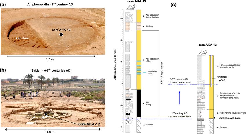
94                                              C. Flaux et al.: The late Holocene record of Lake Mareotis, Nile Delta, Egypt

                         filen sein, der zuvor in der Chronostratigraphie des Maryut-Sees nachgewiesen wurde. (Abstract was
                         translated by Martin Seeliger.)

1    Introduction                                                 0.2 ka cal BP was characterized by dominant freshwater in-
                                                                  puts except between 1.1 to 0.7 ka cal BP, when a Maryut rel-
Lake Mareotis, precursor of the modern Maryut lagoon lo-          ative lowstand and seawater intrusion are attested. New bio-
cated just south of Alexandria (Egypt), constituted a dense       sedimentological, geochemical, radiocarbon and geoarcheo-
traffic waterway during antiquity (Empereur, 1998), strad-        logical data have helped to shed new light on the evolution of
dling the northwestern Nile Delta. Extensive archeological        Lake Mareotis’ water budget during historical times. In par-
surveys have shed new light on the intense occupation of          ticular, this paper aims to better constrain hydrological con-
its shores between the 4th century BCE and the 7th century        ditions of the lake during the Greco-Roman period and probe
CE (Blue and Khalil, 2010). An archeological synthesis at         the sedimentary hiatus previously described within the lake
the scale of the western delta has demonstrated that paleo-       sequence (Goodfriend and Stanley, 1996; Flaux et al., 2012).
waterways and the overall hydraulic configuration shaped
the geography of ancient settlements (Wilson, 2012). Our
                                                                  2   Materials and methods
knowledge and representation of the ancient water network
is primarily based upon historical statements, in particular      This study is based on sedimentary sequences retrieved from
Strabo (Strabo, XVII, 1, 7; translation Yoyotte et al., 1997),    archeological structures and Lake Maryut. All localities have
according to whom Lake Mareotis was connected to the              been benchmarked relative to mean sea level (tide-gauge data
Nile through several canals on its southern and eastern sides.    from Alexandria taken in 1906) using a differential GPS.
Lake-level oscillations were then mediated by Nile floods.           Akadémia and Kôm de la Carrière are two Roman
Nonetheless, this vision furnishes a static view of the lake,     archeological sites lying on the southwestern waterfront
whose shores were occupied for a period of 1000 years or          of Lake Maryut (Fig. 1). At Akadémia, one sedimentary
more, as recently underscored at Kom el-Nogous close to           core was taken from a flooded kiln chamber (core AKA19;
Taposiris Magna (Fig. 1), occupied during the New King-           30◦ 590 16.7400 N 29◦ 400 23.5600 E). Another core (AKA12;
dom (Redon et al., 2017). Following Stanley (2019) quoting        30◦ 590 12.3100 N 29◦ 400 07.6800 E; WGS84 coordinate system)
Butzer (1976, p. 56), “it has become difficult to ignore the      was retrieved from the sedimentary filling of a water-wheel
possibility that major segments of ancient Egyptian history       well (Egyptian sakieh). Cores were taken in 2015 using a
may be unintelligible without recourse to an ecological per-      percussion corer Cobra TT and relevant sediment samples
spective.” We suggest that this statement resonates strongly      were extracted for wet sieving and binocular observation of
with the human occupation history of Lake Mareotis, as orig-      the sand fraction. The base of the kiln chamber is used as an
inally perceived by De Cosson (1935).                             upper limit of the water table and the base of the well as a
   Lake Mareotis is part of the coastal belt of the Nile Delta,   lower one. The chronology of both structures, based on their
spread over a structural boundary which separates Pleis-          archeological dating (Pichot and Flaux, 2015; Pichot, 2017),
tocene coastal sandstone ridges to the west and northwest         shows the evolution of the water-table elevation, related to
from the Holocene Nile Delta to the east and southeast            the adjacent Lake Maryut base level.
(Fig. 1). This situation at the deltaic margin made it very          At Kôm de la Carrière eight sedimentary cores were col-
sensitive to hydrological changes, modulated by Holocene          lected in 2015 from a ancient silted quarry (Fig. 2). Core
relative sea-level changes (e.g., Goiran et al., 2018) and Nile   AMR-3 (31◦ 010 07.1500 N, 29◦ 440 07.2700 E; WGS84 coordi-
flow modifications (e.g., Sun et al., 2019). We have previ-       nate system), drilled in the center of the basin, underwent
ously exploited Lake Mareotis sedimentary archives in order       sediment grain size and ostracod analyses at Durham Uni-
to reconstruct its Holocene history (Flaux et al., 2011, 2012,    versity. We used wet sieving to quantify the sediment tex-
2013, 2017), aiming to elucidate the ancient geography and        ture, including the coarse fraction (>2 mm), sand fraction
hydrology of the lake. The marine transgression of the area       (50 µm–2 mm) and silty-clay fraction (125 µm fraction using a binocular
sively predominant in Maryut’s hydrology (7–5.5 ka cal BP)        microscope and identified to species level (Athersuch et al.,
in the context of the African Humid Period (AHP). Between         1989). The core chronology is based on three radiocarbon
5.5 and 2.8 ka cal BP, the end of the AHP is translated by        dates (Table 1), as well as ceramics studied at the Centre
a progressive hydrological shift from a Nile-dominated to         d’Etudes Alexandrines (CEAlex; CNRS, Alexandria).
a marine-dominated lagoon. A hiatus in Maryut’s sedimen-             The stratigraphy of Maryut lagoon’s southeastern basin
tary record precludes investigating the lagoon system be-         was investigated using the new sedimentary section M83,
tween 2.8 and 1.7 ka cal BP. The final phase from 1.7 to          collected in 2014 from the section of a drain crossing the for-

E&G Quaternary Sci. J., 70, 93–104, 2021                                            https://doi.org/10.5194/egqsj-70-93-2021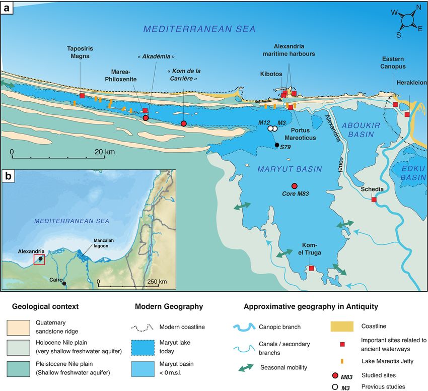
C. Flaux et al.: The late Holocene record of Lake Mareotis, Nile Delta, Egypt                                                        95

Figure 1. (a) Geomorphological map of Lake Mareotis at the northwestern edge of the Nile Delta. (b) Location of the study area along the
southeastern Mediterranean Sea.

mer lagoon bottoms, now cultivated (Fig. 1; 31◦ 20 39.2400 N,         applied to Maryut’s Holocene sedimentary archives (Flaux
30◦ 20 21.5200 E; WGS84 coordinate system). A continuous              et al., 2013). For the 87 Sr / 86 Sr analyses of section M83, we
set of 66 samples, each 2 cm thick, was taken from a                  selected the euryhaline ostracod Cyprideis torosa due to the
1.4 m thick sequence. Bio-sedimentary analyses were under-            species’ wide tolerance to hydrological changes (Frenzel and
taken at CEREGE (CNRS, France). We used wet sieving to                Boomer, 2005). Clean shells were selected and washed with
quantify the sediment texture (including the coarse fraction          Milli-Q water and then dissolved in a 3 N HNO3 solution.
(>2 mm), sand fraction (50 µm–2 mm) and silty-clay fraction           Sr separation and purification techniques used Sr Spec resin
(125 µm frac-                following the procedure modified by Pin et al. (1994). Sr
tion using a binocular and identified to species level (Ather-        isotopic measurements were performed with a NEPTUNE+
such et al., 1989). Sorted mollusk shells were assigned to            Multicollector ICP-MS at CEREGE. A total of 13 replicate
ecological assemblages according to modern faunal groups              analyses of the NBS 987 standard yielded a 87 Sr / 86 Sr ratio
observed on the Nile coast (Bernasconi and Stanley, 1994).            of 0.710264 ± 0.000023 (2σ ), providing a standard error of
Magnetic susceptibility measurements were undertaken us-              ±32 ppm (parts per million). The chronology of core M83 is
ing a Bartington MS2 magnetic susceptibility meter and are            based on seven radiocarbon dates (Table 1).
reported as mass-specific magnetic susceptibility in SI units
(10−8 m3 kg−1 ). Strontium isotopes were measured on ostra-
cod valves for 29 samples (ca. 30 when available; Table 2).           3     Geoarcheological indicators
Reinhardt et al. (1998) analyzed Sr isotopic ratios on surface
and subsurface shell samples taken from Manzala lagoon in             3.1    Sediment record from a silted quarry at Kôm de la
the eastern Nile Delta and showed that this proxy could be                   Carrière
used to reconstruct the recent desalinization of the lagoon,
                                                                      The Kôm de la Carrière site is located on the southwestern
attributed to increasing Nile inflow from the modern irriga-
                                                                      shore of Lake Maryut (Fig. 1) at the foothill of a Pleistocene
tion system. Similar results were obtained from the modern
                                                                      ridge mostly made of poorly consolidated aeolian oolitic car-
northwestern Nile coast (Flaux, 2012, vol. III, p. 13–20) and
                                                                      bonate sands (Gebel Maryut ridge; El Asmar and Wood,

https://doi.org/10.5194/egqsj-70-93-2021                                               E&G Quaternary Sci. J., 70, 93–104, 2021
96                                                   C. Flaux et al.: The late Holocene record of Lake Mareotis, Nile Delta, Egypt

Table 1. Radiocarbon data from the Kôm de la Carrière site (core AMR-3) and section M83. The 14 C activity was calibrated using the
software Calib 8.2 (http://calib.org, last access: February 2021) and the IntCal20 curve (Reimer et al., 2020). No reservoir age correction was
applied to radiocarbon ages (see discussion in Flaux et al., 2012, p. 3497). Extracted collagen was used for the bone sample Poz-88215.

                 Laboratory code       Conventional 14 C age        Error     Material                      Calibrated BCE/CE
                                                                                                            (IntCal20; 2σ )
                 Poz-114734                    111.84 pMC      0.54 pMC       Plant remains                 Recent
                 Poz-114735                           1050            80      Plant remains                 774–1198 CE
                 Poz-114736                           2205            30      Organic sediment              371–175 BCE
                 Beta - 406936                         130            30      Charcoal                      1673–1942 CE
                 Poz-89003                            2310            50      Bittium reticulatum shell     537–203 BCE
                 Poz-89004                            2465            30      Bittium reticulatum shell     760–418 BCE
                 Poz-88215                        >46.000              –      Burnt bone fragment           >45 700 BCE
                 SacA 16171                           2655            30      Cerastoderma valve            898–788 BCE
                 Poz-88214                            1195            30      Organic residue               706–950 CE
                 Poz-89005                            1845            30      Bittium reticulatum shell     122–308 CE

Table 2. Sr isotope data from the ostracod Cyprideis torosa extracted in section M83.

                                 Sample depth below                          Sr isotopic ratio
                                   the surface (cm)
                                                          Cyprideis torosa      87 Sr / 86 Sr       StdErr (abs)
                                                         number of valves
                                   2                 4                  31      0.7088923        6.8995 × 10−06
                                   6                 8                  32      0.7086547        7.1254 × 10−06
                                  10                12                  32      0.7086056        7.3353 × 10−06
                                  16                18                  30      0.7089906        6.8555 × 10−06
                                  22                24                  25      0.7088767        8.4143 × 10−06
                                  32                34                  32      0.7090380        7.2522 × 10−06
                                  36                38                  37      0.7090952        5.6228 × 10−06
                                  40              42.5                  29      0.7090651        7.8184 × 10−06
                                  45                46                  28      0.7084412        7.0303 × 10−06
                                  50                52                  32      0.7085629        6.9299 × 10−06
                                  54                56                  33      0.7083908        6.9392 × 10−06
                                  58                60                  46      0.7083415        6.1782 × 10−06
                                  66                68                  38      0.7084961        7.3548 × 10−06
                                  68                70                  29      0.7086069        7.2733 × 10−06
                                  74                76                  23      0.7085054        7.3531 × 10−06
                                  78                80                  26      0.7086150        6.7636 × 10−06
                                  82                84                  23      0.7087141        7.1005 × 10−06
                                  86                88                  16      0.7084723        6.7583 × 10−06
                                  92                94                  20      0.7086781        6.4997 × 10−06
                                  98               100                  23      0.7083944        8.8246 × 10−06
                                 102               104                  26      0.7086270        7.0049 × 10−06
                                 108               110                  26      0.7081114        7.7709 × 10−06
                                 110               112                  25      0.7087512               0.00002
                                 114               116                  25      0.7087348          4.73 × 10−06
                                 116               118                  30      0.7089914        6.9982 × 10−06
                                 118               120                  38      0.7089995          4.94 × 10−06
                                 122               123                  34      0.7090287          1.83 × 10−05
                                 126               128                  17      0.7090530          4.57 × 10−06
                                 130               135                  57      0.7086334          4.68 × 10−06

E&G Quaternary Sci. J., 70, 93–104, 2021                                                         https://doi.org/10.5194/egqsj-70-93-2021
C. Flaux et al.: The late Holocene record of Lake Mareotis, Nile Delta, Egypt 97
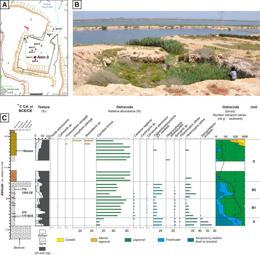
Figure 2. Kôm de la Carrière archeological site. Map (a) and photograph (b) of the silted quarry open toward Lake Maryut (© CEAlex
archive). The quarry was hypothetically used as a lake harbor. Eight cores were taken from the silted quarry to test this hypothesis. Stratig-
raphy and ostracod species and assemblages of core AMR-3 are given in (c).
2000). This bedrock has been carved in the form of a box- Unit A is composed of light gray silts and clays (56 %).
shaped quarry opening onto Lake Maryut (Fig. 2), which led The sand and gravel fractions respectively represent 17 %
El-Fakharani (1991) to suggest that this structure was later and 27 % of the sediment texture. The ostracods comprise
used as a protected harbor in ancient times. Core AMR-3 was an association of freshwater to brackish (86 %) and lagoonal
taken from the silted quarry in order to test this hypothesis. (14 %) species. Heterocypris salina and Sarcypridopsis ac-
Three main units were elucidated along the sedimentary se- uleata, indicative of temporary fresh to brackish water envi-
quence. ronments, constitute 52 % of the ostracod assemblage. The
density is98 C. Flaux et al.: The late Holocene record of Lake Mareotis, Nile Delta, Egypt
Unit B comprises 63 % silts and clays, 17 % sands, and early 7th centuries CE (Fig. 3). The sequence is 3.8 m thick.
20 % gravels. The gravels fraction is dominated by ceramic At the base, unit A is made of alternating fine to coarse oolitic
fragments. There is no color change in relation to unit A. The sand layers, including a few shell fragments and aeolian-
unit is dated between 370–175 cal BCE and 775–1200 cal CE ite gravels corresponding to the upper altered bedrock. The
(1050 ± 80 BP) (Table 1; Fig. 2). first depositional layer in the well comprises hydromorphic
The study of the ostracods allowed us to divide unit B clayey sandy silts (unit B) with a few specimens of the fresh-
into two subunits. Subunit B1 shows a high density of os- water ostracod Candona sp. and potsherd fragments. Unit C
tracods (between 530 and 4800 valves for 10 g of sediment). is broadly made up of a conglomerate of gravels and pebbles
The ecology shows that lagoonal (C. torosa) ostracods dom- within a brown silty-sand matrix. This unit C, 1.5 m thick,
inate this assemblage (75 % of the valves). The remaining likely derived from the abandonment and partial destruction
25 % comprise freshwater (Fabaeformiscandona cf. caudata, of the sakieh’s structure. The latter was stabilized during the
Candona neglecta, Iliocypris sp.) and fresh to brackish wa- last deposition of unit D, characterized by homogeneous yel-
ter species (Heterocypris salina). In subunit B2 the faunal lowish brown silty sands. The well’s base was found at 0.6 m
density is lower and never exceeds 800 valves per 10 g of below msl, while an estimate for the sakieh’s hydraulic wheel
sediment (mean density = 511 valves for 10 g of sediment). diameter and position (Pichot and Empereur, 2013, Annexe
Fresh to brackish water species represent 45 % of the faunal IV, p. 88) shows that the water level in the sakieh’s well when
assemblage, and C. torosa is still dominant with 55 % of the in use was around 1 m above msl (Fig. 3).
identified valves.
Unit C is sandier (27 %), but silts and clays still dominate
the total texture (70 %). The gravels represent (3 %) of the 4 Sediments from section M83 (Fig. 4)
sediment aggregate. The faunal density is very low with a
4.1 Unit A: the Maryut marine lagoon
maximum density of around 75 valves for 10 g of sediment
in the middle of the unit. C. torosa is also dominant in this The upper unit A comprises an alternation of shell-rich and
unit, comprising 93 % of the valves. Freshwater species are dark mud layers deposited at the centimetric scale. Shell-
sporadically present in some samples and represent up to 5 % rich layers comprise very abundant shell fragments and
of the total assemblage. well-preserved and abundant gastropods, mollusks and ostra-
cod valves, the latter sometimes still in connection. Species
density is high and diversity low, dominated by Hydro-
3.2 Sediment record from a kiln firing chamber and a
bia ventrosa (50 %–95 %), followed by Cerastoderma glau-
sakieh well at Akadémia
cum, Loripes lacteus, Bittium reticulatum and Abra sp. The
Akadémia is located on the southwestern shore of Lake ostracod assemblage appears monospecific, represented by
Maryut, close to the ancient site of Marea-Philoxenite, ca. the ubiquist, euryhaline and opportunist species Cyprideis
8 km southwest of Kôm de la Carrière (Fig. 1) on the pied- torosa (Frenzel and Boomer, 2005). The 87 Sr / 86 Sr values
mont of the same Gebel Maryut Pleistocene ridge. Archeo- of Cyprideis torosa valves taken from this unit are around
logical remains at Akadémia are composed of an amphora 0.7090 except one sample close to 0.7086. The upper unit A
workshop (kilns, activity level and a big waste dump) and ends with the deposition of a 4 cm thick layer almost exclu-
a wine press from the 2nd century CE and hydraulic struc- sively composed of shell fragments from the same species as
tures from the 5th to early 7th century CE. The plan view of the unit A assemblage.
one of the amphora kilns shows a semi-buried circular struc-
ture 12.65 m in outside diameter and 7.7 m in inside diam-
4.2 Units B and C: reworked Lake Mareotis muds?
eter. The firing chamber of the amphora kiln was cored in
order to probe its volume and infilling (core AKA19; Fig. 3). Unit B is 0.8 m thick and comprises homogeneous silty clays
The base of the firing chamber was found 4 m below the oven (90 %–95 % of the bulk sediment), dark gray to brown, with
floor at 0.6 m below msl (mean sea level). The first deposit a lumpy structure. Gypsum dominates the composition of the
is a composite, comprising eight layers, 0.1 to 10 cm thick, sand fraction mainly in discoidal lenticular forms. In sec-
of ashen and char sediments intercalated with silty sands and tional view, fine white gypsum was observed in the form
fragments of fired clay bricks. This first deposit translates the of nodules and a mycelium-like morphology. Macrofauna
kiln activity. It is mainly overlain by fragments of fired clay and microfauna are scarce in this unit, but nonetheless the
bricks within a sandy silt matrix, related to the abandonment gastropods Planorbis planorbis and the ostracod Ilyocypris
and the infilling stage of the structure. Four well-defined lay- sp. are present, indicators of lightly brackish conditions, to-
ers of clayey silts, 5–10 cm thick and including a few speci- gether with lagoonal and marine lagoonal species. These
mens of the freshwater ostracod Ilyocypris sp., were interca- low-brackish conditions are confirmed by the 87 Sr / 86 Sr sig-
lated in the coarse sedimentary infilling. nature that decreases significantly to 0.70805 at the base
Core AKA12 retrieved the infilling of a sakieh well found of the unit, although the whole facies is characterized by
on the western part of Akadémia and is dated to the 5th to important fluctuations ranging between 0.70805 and 0.7087
E&G Quaternary Sci. J., 70, 93–104, 2021 https://doi.org/10.5194/egqsj-70-93-2021C. Flaux et al.: The late Holocene record of Lake Mareotis, Nile Delta, Egypt 99
Figure 3. Akadémia archeological site. (a) A 2nd century CE amphora kiln. (b) A 5th to early 7th century CE sakieh (Egyptian water wheel)
500 m westward from the kiln. Both structures are located at ca. 150 m from the modern lakeshores in a similar configuration at the foothill
of a Pleistocene coastal ridge covered by late Quaternary aeolian sands. (c) Comparison between cores AKA-19 and AKA-12 stratigraphies.
The water table must have been below the kiln chamber during its use, then above the lower water wheel, showing a rise between the 2nd to
the 5th century CE.
(Fig. 4). The transition between units A and B is character- data, these muds were mostly reworked from lightly brack-
ized by a decrease in the faunal density and Sr isotope ratio ish lake bottoms deposited between the first millennium BCE
and a sudden increase in magnetic susceptibility from 0 to and the first millennium CE.
70 × 10−8 m3 kg−1 .
The next unit C comprises compact dark gray clayey silts 4.3 Unit D: Lagoon regression
with a lumpy structure. There is a rich gypsum layer with a
pseudo-mycelium structure. Macrofauna density remains are The lower and upper interfaces of unit D were sharply de-
just a few individuals per 100 g of dry sediment, although it fined. The facies shows an increase in fine-sand inputs that
peaks to >10 individuals towards the lower half of the unit, reach ca. 50 % of the sediment bulk. Sands are dominated by
dominated by lightly brackish species (Planorbis planorbis quartz minerals. A laminated structure is partially preserved
and Bellamya sp.); Cyprideis torosa density increases rapidly with alternations of sand-rich and mud-rich infra-millimetric
from tens to hundreds of individuals from the base of unit C layers. The faunal assemblage is characterized by the return
then decreases to tens of individuals per gram of sediments. of lagoonal species sensu stricto and an increase in Cyprideis
The 87 Sr / 86 Sr ratio in unit C ranges between 0.7083 and torosa densities up to several thousand individuals per gram
0.70855. of dry sediment. Three 87 Sr / 86 Sr values display a narrow
Radiocarbon data from units B and C show great incon- range between 0.709 and 0.7091 and signal the return of
sistency (Fig. 4). Three samples, taken from the base of unit marine-dominated conditions.
B, display ages ranging from 900 BCE to 950 CE. A shell
from the middle of unit B was dated to 760–420 BCE, while 4.4 Unit E: final lagoon stage
a burnt bone taken from the same level dates to late Pleis-
tocene times (>45 700 BCE; Fig. 4). Lastly, the upper unit C Unit E provides the last record of section M83. The sand frac-
was dated from 540 to 200 BCE. Such a discrepancy, coupled tion, dominated by quartz minerals, decreases to 25 %–50 %
with age inversions, suggests that units B and C consist of re- in the lower half and 10 %–25 % in the upper part. The unit
worked muds. Given the macrofauna and 87 Sr / 86 Sr and 14 C contains a few individuals of lagoonal shells (Hydrobia sp.
and Cerastoderma glaucum). The 87 Sr / 86 Sr ratio comprises
https://doi.org/10.5194/egqsj-70-93-2021 E&G Quaternary Sci. J., 70, 93–104, 2021100 C. Flaux et al.: The late Holocene record of Lake Mareotis, Nile Delta, Egypt
Figure 4. Multi-proxy analysis of section M83 taken from southeastern Lake Maryut (Fig. 1). The mass fraction of seawater was estimated
via a two-component mixing equation using modern seawater and Nile river water 87 Sr / 86 Sr signatures (details in Reinhard et al., 1998 and
Flaux et al., 2013)
a wider range between 0.7086 and 0.709, indicating a fluctu- modern Lake Maryut shoreline. The base of the kiln’s firing
ating water budget from fluvial to marine dominated. A char- chamber lies at a similar depth to the base of the sakieh well,
coal sample was radiocarbon dated to the modern period, in suggesting a rise in the water table between the 2nd (kiln
agreement with historical accounts from the 16th to the 18th activity) and the 5th to early 7th (sakieh activity) centuries
centuries CE, which describe, from year to year, alternating CE, which is in accordance with clayey silt layers including
lacustrine, lagoonal and salt marsh landscapes in the Maryut a few specimens of the freshwater ostracod Ilyocypris sp.,
basin (Flaux et al., 2012). translating stagnant water after the inundation of the firing
chamber posterior to its use (Fig. 3). In light of estimates
for the sakieh’s hydraulic wheel diameter and position (Pi-
5 Lake Mareotis’ contrasting sedimentary record chot and Empereur, 2013, Annexe IV, p. 88), a minimum rise
in the water table of 1.5 m is inferred (Fig. 3). Because the
5.1 Lake Mareotis desalinization during the first water table, given the shoreline context of the site and the
millennium BCE and Roman water-level rise porosity of loose sediments that compose the substrate of
Mixed sediments deposited in section M83 have nevertheless both structures, is probably controlled by the base level of
recorded, according to fauna and 87 Sr / 86 Sr, dominant Nile Lake Maryut, it is suggested that Akadémia’s remains have
inputs to Maryut’s water budget for a broad period spanning recorded a rise in Lake Mareotis’ level during Roman times.
the first millennium BCE to the first millennium CE. This The study at Kôm de la Carrière has revealed that the
assessment is confirmed by lagoonal to freshwater ostracods quarry was excavated before or at the beginning of the Hel-
found in core AMR-3 taken in a sheltered context in relation lenistic period at a time when the level of the lake was be-
to Maryut’s southeastern central basin, i.e., the semi-closed low mean sea level (msl), given that it is not possible to ex-
inundated quarry located along the western Maryut margin tract the stones below shallow water (Fig. 2). Following a
(Fig. 2). These data show that Lake Mareotis was connected subsequent rise in water level, the quarry was transformed
to the Nile. Geoarcheological data at Akadémia and Kôm into a lightly brackish to freshwater basin connected to Lake
de la Carrière confirm and refine hydrological conditions in Mareotis (unit A) and maybe used as a protected harbor. Al-
Greco-Roman times. ternatively, the quarry could have been excavated while dis-
At Akadémia, the kiln and the sakieh lie 500 m from each connected from the lake before the excavation of a canal to-
other in a similar geomorphological context at the foothill of wards the lake. However, the great porosity of the bedrock,
a Pleistocene coastal ridge covered by late Quaternary aeo- made of poorly consolidated fine to coarse sand layers, and
lian sands (El-Asmar and Wood, 2000) ca. 150 m from the the proximity of the lake go against this hypothesis. Our
E&G Quaternary Sci. J., 70, 93–104, 2021 https://doi.org/10.5194/egqsj-70-93-2021C. Flaux et al.: The late Holocene record of Lake Mareotis, Nile Delta, Egypt 101
chronological framework shows that the onset of sedimen- (i) dating inversions, (ii) incoherent juxtaposition of marine
tation is not much earlier than 370–195 cal years BCE (ter- lagoonal, lagoonal and lightly brackish faunistic assemblages
minus post quem), which is consistent with excavations and (unit B), (iii) heterogeneous Sr isotopic ratios (0.70805 and
archeological surveys undertaken upon the adjacent Kôm, 0.7087), (iv) abrupt changes in the magnetic susceptibility
showing an occupation spanning the Greco-Roman period signature of the sediments at the base of the unit B, and
(Pichot, 2017). Moreover, the basin silted during or after the (v) a broken shell layer observed at the interface between
late Roman period and later, as suggested by late Roman units A and B (Fig. 4). These elements may suggest that
sherds discovered in most of the cores drilled into the silted units B and C resulted from the reworking of Lake Mareo-
quarry. Ostracod assemblages from this silting stage (units tis mud bottoms reworked by a high-energy event. At the
B1 and B2) comprise 25 % freshwater (Fabaeformiscandona lake scale, previous chronologies have highlighted an enig-
cf. caudata, Candona neglecta, Iliocypris sp.) and fresh to matic sedimentary hiatus. For instance, in core M12, located
brackish water species (Heterocypris salina), demonstrating in the deeper central part of the lake (Fig. 1), the shell-rich
important freshwater inputs, although Cyprideis torosa dom- facies (identical to M83’s unit A) is directly overlain by a
inates the assemblages and attests to important variations in gypsum-rich facies (consistent with M83’s unit D), mean-
salinity, possibly related to seasonal Nile floods, in particu- ing that sediments from the first millennium BCE to the first
lar in subunit B1. Units B2 and C were deposited between 0 millennium CE are missing (Flaux et al., 2012 and 2013). In
and 1.9 m above msl (Fig. 2), suggesting that Lake Maryut section M3, the upper shelly facies dated from the beginning
was disconnected from the sea at the time of deposition and of the first millennium BCE is overlain by lightly brackish
mainly supplied by Nile inflow. muds from the 2nd–3rd centuries CE (Flaux et al., 2012).
Geoarcheological indicators therefore suggest that (1) Radiocarbon dates from section M83 suggest that sediments
Lake Mareotis was a lightly brackish lagoon and (2) its level may have been reworked from the northern deeper part of
increased by at least ca. 1.5 m between the 2nd and the 5th the basin and were redeposited southeastwards. Goodfriend
centuries CE and lay above msl. Late Pleistocene stiff muds and Stanley (1996) previously described reworked sediments
lying below Holocene sediments (Chen and Stanley, 1993) in core S79 (location in Fig. 1). Faunal assemblages and
represent a relatively impermeable substratum that could 14 C and δ 13 C analyses of shells from the upper 2 m of the
have favored the water-level rise and stabilization above msl. sequence show a mixed layer composed of younger fresh-
It is not clear, however, whether the lake level stabilized water (Corbicula sp., 855 uncal BP) and older reworked la-
above msl or was a seasonal high level linked to the Nile goonal (Cerastoderma sp., 3900 uncal BP) species. The sce-
flood. More data are required to better document the dating nario means that the tsunami wave would have overflowed
and nature of this hydrological change, which is crucial for above the coastal ridge (5 m high above msl in its lower parts)
the interpretation of lakeshore archeological sites. For ex- and across the urban topography of Alexandria, then eroded
ample, the lake-level rise could partially explain the appar- lake-bottom sediments finally redeposited towards the south-
ent abandonment of Lake Mareotis’ southwestern waterfront east. In section M83, the shell fragment layer capping unit
during the 3rd–4th centuries CE (Pichot, 2017). A and mixed marine to low-brackish species from unit B
could have resulted from tsunami wave trains, while domi-
nant lightly brackish fauna in unit C would translate as back-
5.2 Origin of reworked sediments in section M83: a
wash flow from lake margins. M83’s hypothetical tsunamite
tsunamite?
would have been formed some 20 km from the sea (Fig. 1).
M83 chronological framework records a mixed sediment Mega-tsunami sediment imprints can be found several kilo-
layer (units B and C) deposited between two non-reworked meters from the coast (Scheffers and Kelletat, 2003), and re-
laminated facies (units A and D). The lower unit A is com- worked silt and clays found at site M83 may represent the
posed of shell-rich layers with a marine 87 Sr / 86 Sr signa- distal sediment plume.
ture (Fig. 4) intercalated with mud layers. This biofacies is According to historical sources, eight tsunamis or high-
widely attested across Maryut sedimentary archives (Warne energy marine events struck the coast of Alexandria during
and Stanley, 1993; Goodfriend and Stanley, 1996; Flaux et antiquity (Goiran, 2012). Previous research has focused on
al., 2011, 2012, 2013) and formed within a marine lagoon their sedimentological signatures in cores from Alexandria’s
whose deposition ended at the beginning of the first millen- ancient maritime harbors. Goiran et al. (2005) identified a
nium BCE. The upper unit D comprises aeolian sands alter- coarse deposit with older reworked dates, mixed fauna and
nating with muds (unit D), which is consistent with the lake’s coarse sediment inputs, including shock impacts on quartz
drying up stage recorded through evaporitic crust dated from grains (Goiran, 2012). Radiocarbon dates framing the coarse
the end of the 1st millennium CE (Flaux et al., 2012). Con- deposit suggest that it has recorded the tsunami wave that
sistently, units B and C show 14 C datings from the 1st mil- hit Alexandria in 811 or 881 CE (Goiran, 2012). Stanley and
lennia BCE and CE, but the ages are completely reworked Bernasconi (2006) observed a possible tsunamite facies with
within these units, and a sample of late Pleistocene age was mixed fauna and slump-like sediment strata. Overall, both
incorporated into the sediment matrix. This facies presents studies identified, in several coastal sequences of Alexan-
https://doi.org/10.5194/egqsj-70-93-2021 E&G Quaternary Sci. J., 70, 93–104, 2021102 C. Flaux et al.: The late Holocene record of Lake Mareotis, Nile Delta, Egypt
dria’s eastern harbor, a centennial- to millennial-scale sedi- towards the delta’s western margin, and (2) it has discon-
mentary hiatus, as in some of the Lake Mareotis’ sequences. nected the lake from the Aboukir lagoon and thus from the
It remains, however, difficult to link ancient processes to sea, favoring Lake Mareotis’ desalinization and allowing its
missing sediments. In Lake Mareotis, section M83 may have level to rise above msl, as observed at Akadémia and Kôm
recorded mixed sediment reworked from the lake bottoms. de la Carrière archeological sites. In any case, desalinization
The younger reworked age is chronologically consistent with of the northwestern Nile Delta margin could have been key
the high-energy event, providing a terminus post quem to in the development of human occupation in this area dur-
700–950 cal CE. In core M12, given that the gypsum-rich ing the first millennium BCE. At this time, Lake Mareotis
layer following the sedimentary hiatus was dated between became the natural conveyor for drainage and irrigation wa-
the 9th and the 12th centuries CE (Flaux et al., 2012), the ter. Since the Hellenistic period at least, there was increasing
811 or 881 CE tsunami wave may have impacted not only management of the water system around Lake Mareotis, a
Alexandria’s coastal waterfront (Goiran, 2012) but also its process which was accelerated during the Roman period (Pi-
southern lakeside. In section M3, however, the sedimentary chot, 2017) and may have played a significant role in driving
hiatus spans a shorter period, up to the 2nd–3rd centuries lake-level changes.
CE, meaning that an older tsunami would have eroded these Lake Mareotis’ configuration was transformed by the 9th
lake bottoms. Three tsunamic layers deposited during the century CE from a high-level, hypohaline coastal lake to a se-
last 2000 years were found within coastal lagoons protected bkha. While we previously related this environmental change
by 2–20 m high dunes on the northwestern coast of Egypt to the progressive silting up of the Canopic branch and north-
(Salama et al., 2018). western delta irrigation system, our new results instead high-
Alternatively, recurrent gypsum in pseudo-mycelium form light an environmental change related to the impact of possi-
observed in units B and C, as well as their lumpy sediment ble high-energy event(s). A reconstruction of Lake Mareotis
structure and dark color likely related to higher organic in- history requires new approaches and perspectives (Crépy and
put, suggests the development of pedogenic features at site Boussac, 2021).
M83. Soil development would necessarily imply that Lake
Mareotis retreated from this area and would likely derive
from the lake-level lowstand previously recorded after evap- Data availability. All data generated during this study are in-
oritic deposits in sequences M3 and M12 between the 9th cluded in this article or are available from the corresponding author
to the 12th centuries CE (Flaux et al., 2012). Soil biological upon request.
activity or agricultural plowing could also explain rework-
ing dating along units B and C. Although this alternative hy-
pothesis does not explain the enigmatic sedimentary hiatus Author contributions. CF, MG, VP, NM, MeA, AG, PD, CC and
CM conceived the study and wrote the paper. CF, VP, NM, CM
recorded from the deeper part of the lake, it shows that the
and MeA performed fieldwork and provided chronostratigraphies.
tsunami hypothesis requires deeper investigation. Synolakis
MG performed ostracod analyses. CF, AB, PP and CC performed
and Fryer (2001) and Marriner et al. (2017) caution that every Sr isotopes analyses.
coastal enigma does not necessarily have a tsunami explana-
tion.
Competing interests. The authors declare that they have no con-
flict of interest.
6 Conclusion
Lake Mareotis was densely occupied during Greco-Roman Special issue statement. This article is part of the special issue
times. The present contribution aims to better constrain hy- “Geoarchaeology of the Nile Delta”. It is not associated with a con-
drological conditions of the lake during this period. Faunal ference.
remains, the Sr isotopic signature of ostracods and geoarche-
ological indicators of lake levels show both a rise in Nile in-
puts to the basin during the first millennia BCE and CE and a Acknowledgements. We thank Hélène Mariot for taking care of
lake-level rise of ca. 1.5 m during the Roman period. Such CEREGE’s clean lab. Matthieu Giaime acknowledges the support
changes highlight a complex co-evolution of Alexandria’s of the Institute of Advanced Studies and the Department of Geog-
raphy at Durham University. We thank two anonymous referees for
lakeside occupation history and Nile flow changes, the latter
constructive comments on an earlier version of the manuscript. We
being divided into fluctuating distributaries at the delta scale
thank Martin Seeliger for kindly translating the abstract into Ger-
that were furthermore diverted by irrigation and drainage net- man.
works (e.g., Blouin, 2006). From a forward-looking view-
point, the Alexandria canal (see location in Fig. 1) may have
played a crucial role in the evolution of Lake Mareotis’ wa-
ter budget: (1) it has partially diverted the Canopic Nile flow
E&G Quaternary Sci. J., 70, 93–104, 2021 https://doi.org/10.5194/egqsj-70-93-2021C. Flaux et al.: The late Holocene record of Lake Mareotis, Nile Delta, Egypt 103
Financial support. This research has been supported by the ANR ing the last 2000 years, J. Archaeol. Sci., 39, 3493–3504,
(France) (grant no. ANR-12-SENV-0008-03), the Investissement https://doi.org/10.1016/j.jas.2012.06.010, 2012.
d’Avenir (France) (grant no. EQUIPEX ASTER-CEREGE), and the Flaux, C., Claude, C., Marriner, N., and Morhange, C.: A 7500
Durham Junior Research Fellowship (grant no. 609412). years strontium isotope record from the northwestern Nile
delta (Maryut lagoon, Egypt), Quaternary Sci. Rev., 78, 22–33,
https://doi.org/10.1016/j.quascirev.2013.06.018, 2013.
Review statement. This paper was edited by Julia Meister and Flaux, C., El-Assal, M., Shaalan, C., Marriner, N., Morhange,
reviewed by two anonymous referees. C., Torab, M., Goiran, J.-P., and Empereur, J.-Y.: Geoarchae-
ology of Portus Mareoticus: Ancient Alexandria’s lake har-
bour (Nile Delta, Egypt), J. Archaeolog. Sci. 13, 669–681,
https://doi.org/10.1016/j.jasrep.2017.05.012, 2017.
Frenzel, P. and Boomer, I.: The use of ostracods from marginal
References
marine, brackish waters as bioindicators of modern and Quater-
nary environmental changes, Palaeogeogr. Palaeocl., 225, 68–92,
Athersuch, J., Horne, D. J., and Whittaker, J. E.: Marine and Brack- 2005.
ish Water Ostracods (Superfamilies Cypridacea et Cytheracea): Goiran, J.-P.: Caractérisation d’un dépôt de tsunami dans le port an-
Keys et Notes for the Identification of the Species, Brill Archive, tique d’Alexandrie par l’étude exoscopique des quartz: apports
New Work, USA, 1989. et limites de la méthode, in: Archéosismicité & Tsunamis en
Bernasconi, M. P. and Stanley, D. J.: Molluscan biofacies and their Méditerranée, Approches croisées, edited by: Rébé-Marichal, I.,
environmental implications, Nile delta lagoons, Egypt, J. Coast. Laurenti, A., Boehm, I., and Goiran, J.-P., Editions APS, Perpig-
Res., 10, 440–465, 1994. nan, France, 157–190, 2012 (in French).
Blouin, K.: Homme et milieu dans le nome mendésien à l’époque Goiran, J.-P., Marriner, N., Morhange, C., Abd El-Maguid, M.,
romaine (1er au 6e s.), PhD thesis, University of Nice Sophia Espic, K., Bourcier, M., and Carbonel, P.: Évolution géomor-
Antipolis, France and University of Laval, Québec, Canada, 558 phologique de la façade maritime d’Alexandrie (Egypte) au
pp., 2006 (in French). cours des six derniers millénaires, Méditerranée, 104, 61–65,
Blue, L. and Khalil, E. (Eds.): Lake Mareotis: Reconstructing the https://doi.org/10.4000/mediterranee.2132, 2005 (in French).
Past, Proceedings of the International Conference on the Archae- Goiran, J.-P., Vittori, C., Noirot, B., and Torab, M.: Relative Sea
ology of the Mareotic Region, Bar International Series 2113, Ox- Level Variations at Alexandria (Nile Delta, Egypt) over the
ford, England, 2010. Last Millennia: Archaeological Implications for the Ancient Har-
Butzer, K. W.: Early Hydraulic Civilization in Egypt, University of bour, Verlag der Österreichischen Akademie der Wissenschaften,
Chicago Press, Chicago, USA, 1976. Wien, 2018.
Chen, Z. and Stanley, D. J.: Alluvial stiff muds (late Pleistocene) Goodfriend, G. A. and Stanley, J.-D.: Reworking and discontinu-
underlying the lower Nile delta plain, Egypt: petrology, stratig- ities in Holocene sedimentation in the Nile delta: documentation
raphy and origin, J. Coast. Res., 9, 539–576, 1993. from amino acid racemization and stables isotopes in mollusks
Crépy, M. and Boussac, M.-F.: Western Mareotis lake(s) dur- shells, Mar. Geol., 129, 271–283, https://doi.org/10.1016/0025-
ing the Late Holocene (4th century BCE–8th century CE): di- 3227(96)83348-2, 1996.
achronic evolution in the western margin of the Nile Delta Marriner, N., Kaniewski, D., Morhange, C., Flaux, C., Giaime,
and evidence for the digging of a canal complex during the M., Vacchi, M., and Goff, J.: Tsunamis in the geological
early Roman period, E&G Quaternary Sci. J., 70, 39–52, record: Making waves with a cautionary tale from the Mediter-
https://doi.org/10.5194/egqsj-70-39-2021, 2021. ranean, Sci. Adv., 3, 10, https://doi.org/10.1126/sciadv.1700485,
De Cosson, A.: Mareotis, Being a Short Account of the History of 2017.
Ancient Monuments of the North-western Desert of Egypt and Pichot, V.: Aux portes d’Alexandrie. Le développement de la
of Lake Mareotis, Country Life Ltd., London, USA, 1935. Maréotide hellénistique et romaine, PhD thesis, Lyon 2 Lumière
El-Asmar, H. M. and Wood, P.: Quaternary shoreline development: University, Lyon, France, 1391 pp., 2017 (in French).
the northwestern coast of Egypt, Quaternary Sci. Rev., 19, 1137– Pichot, V. and Empereur, J.-Y.: Rapport de la campagne de fouille
1149, https://doi.org/10.1016/S0277-3791(99)00097-9, 2000. juin–août 2013 sur le site d’Akadémia (Égypte), Rapport pour
El-Fakharani, F. A.: The Kibotos of Alexandria, Studi Miscellanei, le Ministère de l’Europe et des affaires étrangères, CEAlex,
28, 21–28, 1991. Alexandria, Egypt, 102 pp., 2013 (in French).
Empereur, J.-Y.: Alexandrie redécouverte. Fayard, Paris, 254 pp., Pichot, V. and Flaux, C.: Les fours à amphores du Haut-Empire du
1998. site d’Akadémia (Maréotide): campagne de fouille et carottages
Flaux, C.: Holocene Coastal Palaeo-environment of Maryut Lake 2014, Bulletin de liaison de la Céramique Égyptienne (BCE), 25,
in the Northwestern Nile delta, Egypt, PhD thesis, Aix-Marseille 259–276, 2015 (in French).
University, Marseille, France, 413 pp., 2012. Pin, C., Briot, D., Bassin, C., and Poitrasson, F.: Concomitant sepa-
Flaux, C., Morhange, C., Marriner, N., and Rouchy, J.-M.: Bilan ration of strontium and samarium-neodymium for isotopic anal-
hydrologique et biosédimentaire de la lagune du Maryût (delta du ysis in silicate samples, based on specific extraction chromatog-
Nil, Egypte) entre 8000 et 3200 ans cal. B.P., Géomorphologie, 3, raphy, Anal. Chim. Acta, 298, 209–217, 1994.
261–278, https://doi.org/10.4000/geomorphologie.9474, 2011. Redon, B., Vanpeene, M., and Pesenti, M.: La vigne a été inven-
Flaux, C., El-Assal, M., Marriner, N., Morhange, C., Rouchy, tée dans la ville égyptienne de Plinthine, A propos de la décou-
J.-M., Soulié-Märsche, I., and Torab, M.: Environmental verte d’un fouloir saïte à Kôm el-Nogous (Maréotide), Bulletin
changes in the Maryut lagoon (northwestern Nile delta) dur-
https://doi.org/10.5194/egqsj-70-93-2021 E&G Quaternary Sci. J., 70, 93–104, 2021104 C. Flaux et al.: The late Holocene record of Lake Mareotis, Nile Delta, Egypt de l’Institut français d’archéologie orientale (BIFAO), 116, 303– Stanley, J.-D.: Egypt’s Nile Delta in Late 4000 Years BP: 323, https://doi.org/10.4000/bifao.440, 2017 (in French). Altered Flood Levels and Sedimentation, with Archae- Reimer, P., Austin, W., Bard, E., Bayliss, A., Blackwell, P., Bronk ological Implications, J. Coast. Res., 35, 1036–1050, Ramsey, C., Butzin, M., Cheng, H., Edwards, R. L., Friedrich, https://doi.org/10.2112/JCOASTRES-D-19-00027.1, 2019. M., Grootes, P. M., Guilderson, T. P., Hajdas, I., Heaton, T. Stanley, J.-D. and Bernasconi, M. P.: Holocene Depositional Pat- J., Hogg, A. G., Hughen, K. A., Kromer, B., Manning, S. W., terns and Evolution in Alexandria’s Eastern Harbor, Egypt, Muscheler, R., Palmer, J. G., Pearson, C., van der Plicht, J., J. Coast. Res., 22, 283–297, https://doi.org/10.2112/04-0348.1, Reimer, R. W., Richards, D. A., Scott, E. M., Southon, J. R., 2006. Turney, C. S. M., Wacker, L., Adolphi, F., Büntgen, U., Capano, Sun, Q., Liu, Y., Salem, A., Marks, L., Welc, F., Ma, F., Zhang, W., M., Fahrni, S. M., Fogtmann-Schulz, A., Friedrich, R., Köhler, Chen, J., Jiang, J., and Chen, Z.: Climate-induced discharge vari- P., Kudsk, S., Miyake, F., Olsen, J., Reinig, F., Sakamoto, M., ations of the Nile during the Holocene: Evidence from the sed- Sookdeo, A., and Talamo, S.: The IntCal20 Northern Hemisphere iment provenance of Faiyum Basin, north Egypt, Global Planet. Radiocarbon Age Calibration Curve (0–55 cal kBP), Radiocar- Change, 172, 200–210, 2019. bon, 62, 725–757, https://doi.org/10.1017/RDC.2020.41, 2020. Synolakis, C. and Fryer, G. J. : Review of: Tsunami: The under- Reinhardt, E. G., Stanley, J.-D., and Patterson, R. T.: Strontium iso- rated hazard, EOS, 82, 588, https://doi.org/10.1029/01EO00342, topic paleontological method as a high-resolution paleosalinity 2001. tool for lagoonal environments, Geology, 26, 1003–1006, 1998. Warne, A. G. and Stanley, D. J.: Late Quaternary evolution of the Salama, A., Meghraoui, M., El Gabry, M., Maouche, S., Hussein, northwest Nile delta and adjacent coast in the Alexandria region, M. H., and Korrat, I.: Paleotsunami deposits along the coast Egypt, J. Coast. Res., 9, 26–64, 1993. of Egypt correlate with historical earthquake records of eastern Wilson, P.: Waterways, settlements and shifting power in Mediterranean, Nat. Hazards Earth Syst. Sci., 18, 2203–2219, the northwestern Nile Delta, Water Hist., 4, 95–117, https://doi.org/10.5194/nhess-18-2203-2018, 2018. https://doi.org/10.1007/s12685-012-0053-z, 2012. Scheffers, A. and Kelletat, D.: Sedimentologic and geomorphologic Yoyotte, J., Charvet, P., and Gompertz, S.: Strabon, le voyage en tsunami imprints worldwide – a review, Earth-Sci. Rev., 63, 83– Egypte, un regard romain, Nil Edition, Paris, France, 1997. 92, 2003. E&G Quaternary Sci. J., 70, 93–104, 2021 https://doi.org/10.5194/egqsj-70-93-2021
You can also read