Impacts of an intense wildfire smoke episode on surface radiation, energy and carbon fluxes in southwestern British Columbia, Canada
←
→
Page content transcription
If your browser does not render page correctly, please read the page content below
Atmos. Chem. Phys., 19, 835–846, 2019
https://doi.org/10.5194/acp-19-835-2019
© Author(s) 2019. This work is distributed under
the Creative Commons Attribution 4.0 License.

Impacts of an intense wildfire smoke episode on surface radiation,
energy and carbon fluxes in southwestern
British Columbia, Canada
Ian G. McKendry1 , Andreas Christen2 , Sung-Ching Lee1 , Madison Ferrara1 , Kevin B. Strawbridge3 ,
Norman O’Neill4 , and Andrew Black5
1 Department  of Geography, The University of British Columbia, Vancouver, Canada
2 Environmental  Meteorology, Faculty of Environment and Natural Resources,
University of Freiburg, Freiburg, 79085, Germany
3 Air Quality Research Division, Environment Canada, 4905 Dufferin St, Toronto, Canada
4 Centre for Research and Applications in Remote Sensing, Université de Sherbrooke, Sherbrooke, Canada
5 Faculty of Land and Food Systems, The University of British Columbia, Vancouver, Canada

Correspondence: Ian G. McKendry (ian@geog.ubc.ca)

Received: 16 March 2018 – Discussion started: 17 May 2018
Revised: 10 August 2018 – Accepted: 17 December 2018 – Published: 22 January 2019

Abstract. A short, but severe, wildfire smoke episode in July      that wildfire aerosol during the growing season potentially
2015, with an aerosol optical depth (AOD) approaching 9,           plays an important role in the regional ecosystem response to
is shown to strongly impact radiation budgets across four          smoke and ultimately the carbon budget of the region.
distinct land-use types (forest, field, urban and wetland). At
three of the sites, impacts on the energy balance are also
apparent, while the event also appears to elicit an ecosys-
tem response with respect to carbon fluxes at the wetland          1   Introduction
and a forested site. Greatest impacts on radiation and energy
budgets were observed at the forested site where the role of       Wildfire activity is projected to increase in frequency and
canopy architecture and the complex physiological responses        duration over the next century in western North America,
to an increase in diffuse radiation were most important. At        primarily as a result of the increased summer temperatures,
the forest site, the arrival of smoke reduced both sensible and    persistent drought, and reduced snowpack accompanying cli-
latent heat flux substantially but also lowered sensible heat      mate change (IPCC, 2014; Setelle et al., 2014). In addition
flux more than the latent heat flux. With widespread standing      to the obvious impacts on visibility and air quality, aerosols
water, and little physiological control on evapotranspiration,     arising from biomass burning scatter and absorb solar radia-
the impacts on the partitioning of turbulent fluxes were mod-      tion (direct effect) while also influencing cloud processes by
est at the wetland compared to the physiologically dominated       acting as cloud condensation nuclei (indirect effect; IPCC,
fluxes at the forested site. Despite the short duration and sin-   2014). Furthermore, and of particular focus in this work, re-
gular nature of the event, there was some evidence of a dif-       cent studies point to significant impacts on surface turbulent
fuse radiation fertilization effect when AOD was near or be-       and radiative fluxes, boundary layer stability and energetics
low 2. With lighter smoke, both the wetland and forested site      (including cloud development), and the carbon exchange be-
appeared to show enhanced photosynthetic activity (a greater       tween biosphere and the atmosphere (Li et al., 2017).
sink for carbon dioxide). However, with dense smoke, the              Radiative impacts of biomass burning are well docu-
forested site was a strong carbon source. Given the exten-         mented in a variety of settings, including South America
sive forest cover in the Pacific Northwest and the growing         (Moreira et al., 2017; Sena et al., 2013; Schafer et al., 2002),
importance of forest fires in the region, these results suggest    Africa (Schafer et al., 2002), Spain (Calvo et al., 2010), Rus-

Published by Copernicus Publications on behalf of the European Geosciences Union.
836                                                       I. G. McKendry et al.: Impacts of an intense wildfire smoke episode

sia (Chubarova et al., 2012; Pere et al., 2014), North Amer-        burning is likely to have non-trivial impacts on surface cli-
ica (Markowicz et al., 2017; Vant-Hull et al., 2005), and Asia      mates as well as ecosystem productivity and the carbon cycle
(Wang et al., 2007). However, there is growing literature con-      in Canada’s most productive ecozone.
cerned with impacts of smoke plumes on atmospheric bound-              During the summer of 2015, a rare opportunity arose to
ary layer dynamics as well as surface radiation and energy          investigate such impacts under clear skies and for unusually
budgets. For example, Taubman et al. (2004) investigated            high AOD (τ500 ∼ 2.5). A period of prolonged drought and
the impact of a wildfire plume underlain by an urban haze           elevated temperatures resulted in sustained wildfire activity
layer in Virginia and Maryland, US, when aerosol optical            throughout the Pacific Northwest. In early July 2015, a par-
depth (AOD) at 500 nm (τ500 ) varied between 0.42 ± 0.06            ticularly intense event had significant impacts on air qual-
and 1.53 ± 0.21. In that case, atmospheric absorption of so-        ity and visibility in southwestern British Columbia. Ground
lar radiation by the smoke and haze layers resulted in net          level hourly PM2.5 (particulate matter less than 2.5 µm in di-
cooling at the surface and heating of the air aloft, thereby in-    ameter) concentrations approached 200 µg m−3 in the city of
creasing stability. Absorption of solar radiation in the dense      Vancouver on 5 July and were associated with smoke em-
smoke layer maintained a morning subsidence inversion and           anating from approximately 150 km to the northeast in the
thereby created a positive feedback loop preventing vertical        Pemberton region (Fig. 1). By 7 July reports noted that these
mixing and dilution of the smoke plume itself. Wang and             Elaho, Boulder Creek, and Nahatlatch fires had spread to a
Christopher (2006) report a similar broad range of impacts on       combined area of approximately 30 000 ha.
surface radiation and/or energy budgets and boundary layer             In this study, we focus on the impacts of relatively “fresh”
dynamics in a modeling study of the impact of Central Amer-         smoke (∼ 1–2 days old) from these intense temperate conif-
ican biomass burning on the source region as well as the            erous forest fires on the radiation budget across four distinct
southeastern US (for τ550 = 0.09). At the plant canopy scale,       land-use types (wetland, an urban residential area, an agri-
Yamosoe et al. (2006) have focused on the impact of biomass         cultural grass field, and a coniferous forest) as well as sur-
burning aerosol on Amazonian forests and have noted an in-          face energy budgets at three of the sites. Finally, we ten-
crease in diffuse radiation within the canopy combined with         tatively (given limitations due to the short duration of the
a reduction in total photosynthetically active radiation (PAR)      event) explore ecosystem response in terms of carbon fluxes
at the top of the canopy. These impacts affected sensible and       at two of the sites (forest and wetland). In so doing, we
latent fluxes as well as net ecosystem exchange (NEE) of            add a new geographic setting to the growing catalog of such
carbon dioxide (CO2 ). Subsequently, Steiner et al. (2013)          ecosystem impacts and compare the results with studies from
have explored such ecosystem responses using data from              other regions. Furthermore, the availability of sunphotome-
six US FLUXNET sites and demonstrate that high AOD re-              ter and aerosol LiDAR data from the immediate area greatly
duces midday net radiation by 6 %–65 % coupled with a 9 %–          enriches the information available for interpretation of this
30 % decrease in sensible and latent heat fluxes. Niyogi et         event.
al. (2004), in an examination of six AmeriFlux sites, con-
clude that aerosols can exert a significant impact on net CO2
exchange (perhaps more so than clouds), whereby the CO2             2     Background and data sources
sink is increased with aerosol loading for forest and crop-
lands. This effect has become known as the diffuse radiation        2.1    Synoptic overview
fertilization effect (DRF), whereby an increase in photosyn-
thesis results from a trade-off between decreased solar radi-       During 2–6 July 2015, western Canada was under the influ-
ation and increased light scattering during clouds or smoke         ence of a 500 hPa ridge of high pressure centered off-shore
(Park et al., 2018, and references therein). It is suggested that   at 135◦ W. This resulted in northwesterly upper-level flow
the magnitude of the effect is controlled by canopy architec-       across southwestern British Columbia. At the surface, a ther-
ture, leaf area index and plant functional type. Finally, an ex-    mal trough was located along the Western Cordillera, a pat-
tensive review of these and other factors (including forest fire    tern associated with poor air quality in the region (McKendry,
aerosols) affecting productivity and carbon fluxes, with a fo-      1994). Vancouver International Airport recorded maximum
cus on the northern Australian savanna biome, can be found          daily temperatures in the range 25–27 ◦ C from 2–6 July, with
in Kanniah et al. (2010).                                           nighttime minima of 21 ◦ C. Skies were generally cloudless
   In western Canada, previous studies have examined the            with no precipitation recorded, and maximum wind gusts
chemistry and transport of smoke plumes as well as the im-          were of ∼ 10 m s−1 .
pacts on local air quality (Cottle et al., 2014; McKendry et al.,      Commercial aircraft soundings (Aircraft Meteorological
2010, 2011). However, to date, the impacts on radiation and         Data Relay – AMDAR) from Vancouver International Air-
energy budgets, boundary layer dynamics, and ecosystems             port (YVR) departures and arrivals show development of a
have not been addressed for biomass burning associated with         strong surface-based inversion late on 4 July that persisted
the coastal temperate coniferous forest biome. As the risk of       through 5 July 2015 and coincided with smoke arrival mid-
wildfire increases in such areas (Setelle et al., 2014) biomass     afternoon on 5 July over the western edge of the lower Fraser

Atmos. Chem. Phys., 19, 835–846, 2019                                                 www.atmos-chem-phys.net/19/835/2019/
I. G. McKendry et al.: Impacts of an intense wildfire smoke episode                                                         837

                                                                 housed in a cargo trailer with modifications including a
                                                                 roof hatch assembly, basic meteorological tower, radar inter-
                                                                 lock system, climate control system, and leveling stabilizers.
                                                                 A Continuum Inlite III (small footprint) laser operating at
                                                                 1064/532 nm simultaneously, with a pulse repetition rate of
                                                                 10 Hz, is the foundation of the system. The upward-pointing
                                                                 system measures the return signal in three channels (1064 nm
                                                                 and two polarization channels at 532 nm). The system is de-
                                                                 scribed in detail by Strawbridge (2013), and an example of
                                                                 its application is shown in Cottle et al. (2014).

                                                                 2.3   AERONET and AEROCAN

                                                                 The global AERONET (Aerosol Robotic Network) has op-
                                                                 erated since 1993 and is focused on measurements of ver-
                                                                 tically integrated aerosol properties using the CIMEL sun-
                                                                 photometer and sky radiometer instrument (Holben et al.,
                                                                 1998). AEROCAN CIMELs (AEROCAN is the Canadian
                                                                 sub-network of AERONET) include a facility on Saturna Is-
                                                                 land, 55 km to the south of the UBC site. Here, solar irradi-
                                                                 ances are acquired across eight spectral channels (340, 380,
                                                                 440, 500, 670, 870, 1020, and 1640 nm) that are transformed
                                                                 into three processing levels of aerosol optical depth (AOD):
                                                                 1.0 is non-cloud screened, 1.5 is cloud screened, and 2.0 is
                                                                 cloud screened and quality assured. McKendry et al. (2011)
                                                                 demonstrated the application of these data to the transport of
                                                                 California wildfire plumes. In this paper, as in McKendry et
                                                                 al. (2011), the SDA (spectral deconvolution algorithm) was
                                                                 applied to Level 1.0 AOD spectra in order to better delin-
                                                                 eate the strongly varying contribution of fine-mode smoke
                                                                 particles at a reference wavelength of 500 nm. Level 1.0 in-
                                                                 put AODs were chosen to minimize “false negative” smoke-
                                                                 AOD rejection attributed to the Level 1.5 cloud-screening al-
                                                                 gorithm.

                                                                 2.4   Radiative and turbulent flux data

                                                                 The smoke event of July 2015 coincided with a period in
Figure 1. Map with inset showing all places mentioned in text.   which routine long-term measurements of surface radiation
                                                                 and turbulent fluxes (sensible and latent heat using the eddy-
                                                                 covariance method) were made at three sites in the region,
Valley (see Supplement). At that time, the inversion top was     while at a fourth site only the radiation budget was ob-
at ∼ 500 m above ground and was ∼ 10 K in magnitude. As          served (Table 1). Photographs of the sites, a detailed descrip-
shown below, this strong inversion effectively trapped the       tion of the instrumentation, discussion of instrumental inter-
smoke plume below it and was likely responsible for the high     comparability, corrections applied, and data manipulations
particulate matter concentrations and poor visibility observed   are provided in the Supplement. Turbulent fluxes were cor-
on 5 July. By 6 July this capping inversion was no longer        rected for spike removal, density fluctuations (Webb et al.,
present and likely disappeared as a result of the evolving       1980), and sensor separation effects. Data processing at all
weather pattern and advection.                                   sites were cross-checked against standardized SMARTFlux
                                                                 processing algorithms (LI-COR Inc.).
2.2   LiDAR                                                         Buckley Bay (Ca-Ca3) is a flux tower with eddy-
                                                                 covariance and radiation sensors measuring the exchange be-
The Environment Canada UBC LiDAR has operated since              tween a coniferous forest stand (Douglas fir, 27 years old)
2008 at the University of British Columbia (UBC – Totem          and the atmosphere. The site is located on the eastern slopes
Field – see Fig. 1). This remotely controlled facility was       of the Vancouver Island Ranges, about 150 km to the west

www.atmos-chem-phys.net/19/835/2019/                                                Atmos. Chem. Phys., 19, 835–846, 2019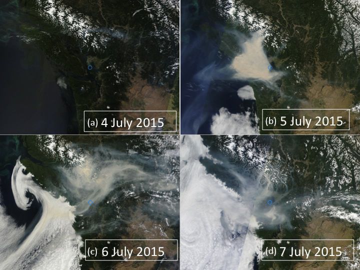
838                                                        I. G. McKendry et al.: Impacts of an intense wildfire smoke episode

Table 1. Measurements and site characteristics (bullets indicate measurements).

                Site                    FLUXNET ID        Energy budget      Radiation budget   NEE   Coordinates
                land cover                                                                            (WGS-84)
                Buckley Bay             Ca-Ca3                   •                  •            •    124◦ 540 1.4400 W
                coniferous forest                                                                     49◦ 320 4.6300 N
                Burns Bog               Ca-DBB                   •                  •            •    122◦ 590 5.6000 W
                wetland                                                                               49◦ 070 45.5900 N
                Vancouver UBC           –                                           •                 123◦ 140 56.4100 W
                grass                                                                                 49◦ 150 19.5000 N
                Vancouver Sunset        Ca-VSu                   •                  •                 123◦ 40 42.2400 W
                residential urban                                                                     49◦ 130 33.9600 N

of Vancouver. Full descriptions of the site and the instru-            where QF is the heat released inside a volume due to human
ments can be found in Humphreys et al. (2006) and Chen                 activities (anthropogenic heat flux), QH is the turbulent (con-
et al. (2009). Burns Bog (Ca-DBB) is a floating platform               vective) sensible heat flux to the atmosphere, QE is the tur-
with eddy-covariance and radiation instrumentation on an               bulent (convective) latent heat exchange with the atmosphere
open wetland with mosses, sedges, and a significant faction            (including evaporation and transpiration), QG is the conduc-
of standing water. Further details of the site are described in        tive exchange of energy with the underlying substrate, QS
Christen et al. (2016) and Lee et al. (2017). Vancouver Sunset         is the net heat storage in the entire volume above a surface
(Ca-VSu) is an urban observational tower above a residential           (e.g., urban fabric or plant canopy), and QA is the net energy
detached urban neighborhood. Details of the instrumentation            added to or subtracted from a volume due to advection (all
can be found in Crawford and Christen (2014).                          in W m−2 ). In the cases examined here, both QS and QA are
   Vancouver UBC is a climate station on the campus of the             deemed negligible due to judicious site selection, while QF
University of British Columbia that features a full set of ra-         is only of relevance at the Vancouver Sunset site, where it is
diation measurements.                                                  of the order of 20 W m−2 (Oke et al., 2017).
   Based on descriptions and conventions described in                     The Bowen ratio is defined as β = QH /QE and is a mea-
Oke (1987), the surface radiation budget can be defined as             sure of the partitioning of the turbulent heat fluxes. β is de-
                                                                       pendent on availability of water at the surface as well as plant
Q∗ = K↓ − K↑ + L↓ − L↑ ,                                       (1)     physiology and has important consequences for surface cli-
                                                                       mates by influencing both surface temperature and humidity.
where Q∗ is the net all-wave radiation, K↓ is the short-                  Net ecosystem exchange (NEE in µmol m−2 s−1 ) is used
wave irradiance comprising direct and diffuse solar radia-             in quantifying the carbon balance of an ecosystem and is
tion, K↑ is the reflected shortwave radiation, L↓ is the long-         ecosystem respiration (Re ) minus gross ecosystem photosyn-
wave (“thermal”) irradiance from the sky, and L↑ is the long-          thesis (GEP), i.e., NEE = Re − GEP. NEE is negative when
wave radiation emitted and reflected from the surface (all             the ecosystem is acting as a CO2 sink and positive when it is
in W m−2 ).                                                            acting as a CO2 source.
    The ratio K↑ /K↓ is the surface albedo (α) and is the short-
wave reflectance of the surface in the solar band. Kext is the
                                                                       3     Results
extraterrestrial solar radiation and represents the flux density
of solar radiation falling at the outer edge of atmosphere and         3.1    Satellite, LiDAR, and sunphotometer observations
is computed based on date, time, and latitude at the site. The
ratio of K↓ /Kext is a measure of the bulk transmissivity of the       MODIS (Moderate Resolution Imaging Spectrometer) im-
atmosphere to shortwave radiation. PAR, measured at Burns              agery for the period is shown in Fig. 2a–d. On 4 July 2015
Bog only, is shortwave radiation in the range 440–670 nm               the region was cloud and smoke free. By 5 July a plume of
and is typically expressed in terms of photon flux density             smoke from the fires in the Elaho valley near Pemberton is
(µmol m−2 s−1 ).                                                       evident and extends across the southern and central portion
    Furthermore, the non-radiative partitioning of energy par-         of Vancouver Island (including Buckley Bay but not the three
titioning over a surface can be defined in three dimensions            mainland sites). At this time, a “wall of smoke” extended
using the surface energy balance (Oke et al., 2017):                   broadly from northwest to southeast along the Strait of Geor-
                                                                       gia and slightly to the west of the city of Vancouver. This
Q∗ + QF = QH + QE + QG + QS + QA ,                             (2)     smoke moved across the city of Vancouver at approximately

Atmos. Chem. Phys., 19, 835–846, 2019                                                      www.atmos-chem-phys.net/19/835/2019/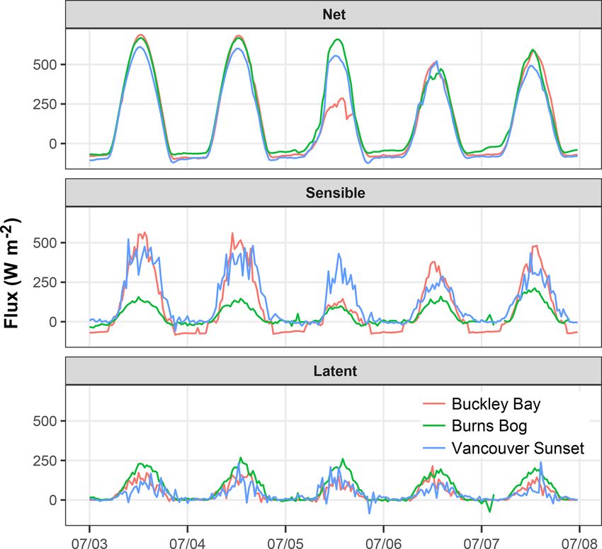
I. G. McKendry et al.: Impacts of an intense wildfire smoke episode                                                                 839

Figure 2. Modis satellite imagery for the period 4–7 July (Saturna
Island shown in blue circle).

15:00 Pacific Daylight Time (PDT) on 5 July 2015 (photo-             Figure 3. Time series for 5–7 July 2017 showing (a) PM2.5 and
graphic evidence is shown in Supplement). HYSPLIT (Hy-               PM10 observations and temperature at Vancouver International Air-
brid Single Particle Lagrangian Integrated Trajectory Model)         port, and (b) aerosol optical depths for fine-mode (FM) and coarse
modeling (see Supplement) at this time confirmed the source,         mode (CM) variation at Saturna Island. The “FM AOD extension”
shape, and extent of the plume. By 6 July, the plume had             was obtained by assuming that the total AOD at the longer wave-
dispersed eastward and was accompanied by cloud to the               lengths of 675 and 870 nm was dominated by the fine-mode AOD
west of Vancouver Island, with a signature consistent with           and extrapolating their AODs back to 500 nm (a choice necessitated
a coastally trapped disturbance (Reason and Dunkley, 1993)           by the fact that the extraordinarily large AODs at the shorter wave-
or marine “stratus surge” as it is commonly known in the re-         lengths were eliminated by AERONET processing), and (c) LiDAR
                                                                     backscatter from the UBC CORAL-NET site at 532 nm for the pe-
gion. However, the region to the east of Vancouver Island re-
                                                                     riod. The red vertical line shows arrival of the low-level wall of
mained cloud free and stayed this way during the 6 July when
                                                                     smoke around 15:00 PDT on 5 July.
dense smoke was still evident across southwestern British
Columbia, including all four of the measurement sites.
   The impact of smoke on air quality in the vicinity of Van-
couver is shown in Fig. 3. LiDAR imagery (Fig. 3c) shows             minimum temperatures at Vancouver International Airport
an elevated layer of smoke over the region at ∼ 2000 m ele-          (Fig. 3a).
vation prior to the arrival of a wall of smoke at ground level          Analysis of sunphotometer (Saturna Island), LiDAR
at approximately 15:00 PDT on 5 July (depicted by the ver-           (UBC) MODIS, AQUA, and CALIOP (Cloud-Aerosol Li-
tical dashed line). Ground level smoke remained in a shal-           dar with Orthogonal Polarization) together reveal a complex
low layer until approximately 06:00 PDT on 6 July. Sub-              three-dimensional structure associated with the smoke event
sequently, smoke continued to persist over the region but            (with layers extending into the 3–6 km range a.g.l.). The
was confined to a shallow layer at ∼ 1750 m elevation a.g.l.         event, as shown in both LiDAR and CALIOP data consisted
Smoke again descended toward ground level on 7 July but did          of multiple layers with the predominately fine-mode particle
not reach the surface. Consequently, PM10 concentrations at          signature of smoke confirmed in the AERONET (Saturna Is-
Vancouver International Airport (Fig. 3a) peaked (reaching           land) data (Fig. 3b). Prior to the arrival of the ground level
250 µg m−3 ) when smoke was at ground level between 15:00            smoke over Vancouver, fine-mode AOD values at Saturna Is-
on 5 July and 06:00 PDT on 6 July. (Note, due to the fact            land were very high (∼ 9 at 11:00 PDT on 5 July) and were
that PM10 is measured with a TEOM instrument and PM2.5               (on the basis of detailed analysis of the MODIS and AQUA
by a Sharp instrument at Vancouver International Airport,            imagery) likely associated with the higher altitude (2–3 km)
differences in instrument principles and calibrations means          smoke plumes. The 15:00 PDT wall of smoke mentioned
that under elevated fine-mode particulate matter conditions,         above is seen as a sharp fine-mode AOD rise at Saturna fol-
PM2.5 values may approach or marginally exceed measured              lowing the decay of the strong 11:00 peak of the 2–3 km layer
PM10 values, as occurred in this case). Over the entire pe-          (a rise that started around 12:30 PDT on 5 July; the 2.5 h dif-
riod there was a modest decrease in daytime maximum and              ference being a function of the transport time from Saturna

www.atmos-chem-phys.net/19/835/2019/                                                      Atmos. Chem. Phys., 19, 835–846, 2019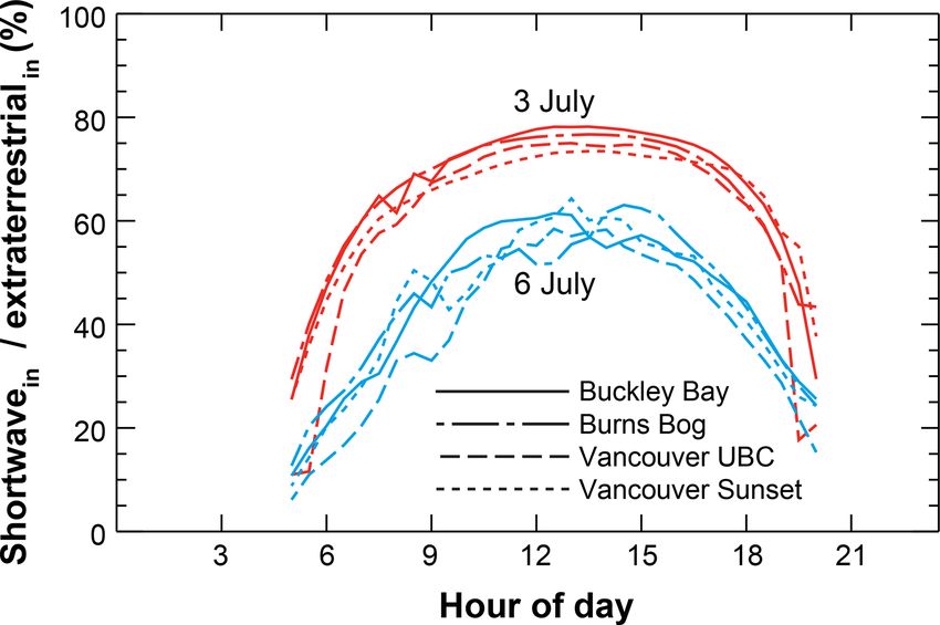
840                                                      I. G. McKendry et al.: Impacts of an intense wildfire smoke episode

                                                                   Figure 5. Diurnal impacts on incoming solar radiation at each site
                                                                   for 3 (cloudless day) and 6 (smoke) July.

                                                                      With respect to remaining radiation budget components,
                                                                   arrival of smoke at all sites was marked by a reduction in Q∗ .
                                                                   However, variations in L↓ and L↑ were subtle and point to
                                                                   only modest changes in surface or atmospheric temperatures
                                                                   (Fig. 3a). Albedo (Table 2) also increased at the two Vancou-
                                                                   ver sites as well as the Buckley Bay site with the arrival of
Figure 4. Radiation budget components using standard convention.
                                                                   smoke and likely is a consequence of the reduction in specu-
Fluxes away from surface plotted as negative values.
                                                                   lar reflection during direct solar irradiance and an increase in
                                                                   diffuse reflection.
to UBC, and the time that a significant increase in fine-mode         Diurnal impacts of the smoke event on atmospheric trans-
AOD could be detected at Saturna).                                 missivity are shown in Fig. 5, where a clear non-smoke day
                                                                   (3 July 2015) is directly compared with 6 July 2015. Of note,
3.2   Impact on radiation and energy budgets                       the impact of the low-level smoke is apparent in the signif-
                                                                   icant reductions in transmissivity throughout the day. How-
The course of diurnal radiation budget components at each          ever, near sunrise and sunset, 3 and 6 July have almost the
site is shown in Fig. 4, while daily averages are listed in Ta-    same irradiance at a low sun angle, presumably due to the
ble 2. On both 3 and 4 July, all sites show a smooth diur-         presence of more diffuse light. Secondly, the impacts are the
nal course of radiation components consistent with summer          same across all sites and ecosystems and therefore demon-
clear-sky conditions. On these days, mean daily atmospheric        strate a clear regional signal consistent with the widespread
bulk transmissivity (K↓ /Kext ) was approximately 80 % at all      smoke distribution shown in Fig. 2c.
sites (Table 2). The most dramatic impact of the smoke plume          The course of sensible (QH ) and latent (QE ) turbulent
on radiation components occurred on 5 July at Buckley Bay,         heat fluxes are shown in Fig. 6 and are summarized in Ta-
when the mean daily transmissivity dropped to 40 % with a          ble 2. As with K↓ above, the most significant impact on QH
reduction in midday K↓ of 49 % (to 475 W m−2 ) compared            was at Buckley Bay on 5 July, where it decreased to 18 %
to midday values on 3 and 4 July (∼ 920 W m−2 ). This is           (i.e., 41.4 W m−2 ) of clear-sky mean daytime time values.
consistent with satellite imagery (Fig. 2) which shows the         At Vancouver Sunset (6 July) and Burns Bog (5 July), the
smoke layer persisting over Buckley Bay for the entire day         greatest reductions in QH were to 52 % and 45 % respec-
on 5 July. At mainland sites, the late arrival of smoke at ap-     tively of the daytime values on the clear-sky days preceding
proximately 15:00 PDT on 5 July is evident in the late after-      the episode. The impacts on QE were less than for QH at
noon K↓ but had less impact on daily totals. Instead, at these     all sites. At Burns Bog, the minimum for QE occurred on
mainland sites the biggest impact of the smoke occurred on         6 July, whereas at Vancouver Sunset, it was on 7 July, and
6 July, when daily transmissivities dropped to 52 %–57 %           at Buckley Bay, it was on 5 July. At all sites, β was signifi-
and peak midday K↓ values were reduced by approximately            cantly reduced on 5 July, with the greatest reduction at Buck-
15 %–25 % compared with those observed on the 3 and 4              ley Bay (from β = 3.21 to 0.84). The latter was the result of
July. On this day, LiDAR imagery shows the smoke layer to          the large reduction in QH at that site (82 %) and the rela-
be at a higher elevation, with less intense backscatter than       tively small reduction in QE (32 %). The switch from high
seen late on 5 July (Fig. 4a).                                     direct radiation on 3 and 4 July to predominately diffuse ra-

Atmos. Chem. Phys., 19, 835–846, 2019                                                 www.atmos-chem-phys.net/19/835/2019/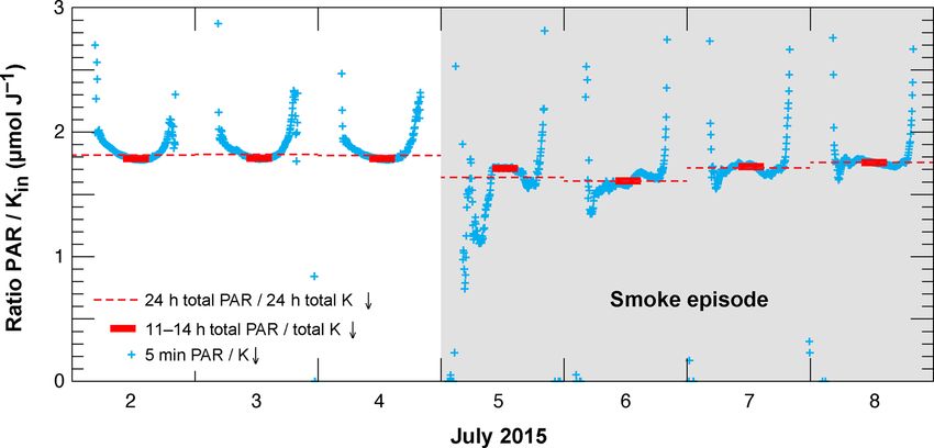
I. G. McKendry et al.: Impacts of an intense wildfire smoke episode                                                                                   841

Table 2. Daily averages of radiative and turbulent fluxes, Bowen ratio, and carbon dioxide fluxes on 3–7 July for each of the four sites.

                                3 July 2015                4 July 2015                5 July 2015            6 July 2015         7 July 2015
        Kext                    MJ m−2 day−1
                                37.0                       36.8                       36.7                   36.4                36.2
        Shortwave K↓            MJ m−2 day−1
        Burns Bog               29.5 (78 %)*               29.4 (78 %)                25.3 (69 %)            20.8 (57 %)         23.8 (65 %)
        Van. Sunset             28.3 (76 %)                28.1 (76 %)                23.4 (63 %)            20.8 (57 %)         21.6 (60 %)
        Van. UBC                28.2 (76 %)                27.8 (76 %)                21.5 (59 %)            18.9 (52 %)         19.7 (54 %)
        Buckley Bay             29.8 (81 %)                29.9 (81 %)                14.4 (39 %)            21.2 (58 %)         24.4 (67 %)
        Albedo (α)
        K↑ /K↓
        Burns Bog               0.18                       0.18                       0.18                   0.18                0.17
        Van. Sunset             0.16                       0.15                       0.17                   0.17                0.16
        Van. UBC                0.29                       0.30                       0.37                   0.35                0.34
        Buckley Bay             0.13                       0.13                       0.17                   0.15                0.14
        Sensible heat           Daytime
        QH                      (W m−2 )
        Burns Bog               67.3                       63.4                       30.5                   60.0                97.6
        Van. Sunset             250.7                      247.3                      136.5                  130.1               176.4
        Buckley Bay             232.8                      217.5                      41.4                   136.9               179.3
        Latent heat             Daytime
        QE                      (W m−2 )
        Burns Bog               116.8 (β = 0.58)           112.8 (β = 0.56)           99.6 (β = 0.31)        89.8 (β = 0.67)     96.4 (β = 1.01)
        Van. Sunset             53.6 (β = 4.68)            57.8 (β = 4.28)            62.7 (β = 2.18)        48.3 (β = 2.69)     39.0 (β = 4.52)
        Buckley Bay             72.4 (β = 3.21)            70.1 (β = 3.10)            49.1 (β = 0.84)        60.3 (β = 2.27)     53.5 (β = 3.35)
        CO2 (NEE)               g C m−2 day−1
        (daily mean)
        Burns Bog               −1.67                      −1.64                      −2.47                  −3.64               −4.24
        Buckley Bay             0.16                       1.26                       1.13                   −1.35               −2.31

      * percentage of Kext (extraterrestrial radiation); daytime Bowen ratio – β = QH /QE

diation on 5 July was likely responsible for the marked re-                                 tent over the seven previous precipitation-free days (mean
duction in QH as a consequence of reduced heating of leaves                                 −1.69 g C m−2 day−1 ). The peak radiative impact of the
in a highly coupled forest canopy (Brümmer et al., 2012). In                                smoke at Burns Bog occurred on 6 July (albeit somewhat
summary, evapotranspiration was maintained at all sites with                                lesser in magnitude than what occurred at Buckley Bay) and
the wettest sites (Burns Bog) showing the lowest response to                                was associated with a daily NEE of −3.64 g C m−2 day−1
the smoke plume. However, impacts on QH were greatest at                                    (net sink). This effect was even more pronounced on the fol-
the forested site (Buckley Bay).                                                            lowing day.
                                                                                               Conversely, at the Buckley Bay forested site, the
3.3   Impact on carbon budget and PAR                                                       pre-smoke arrival daily NEE on 3 July showed a
                                                                                            CO2 neutral situation (0.16 g C m−2 day−1 ). Again, as
Daily values for NEE are shown in Table 2 for two sites                                     with the Burns Bog site, this was consistent with the
(Burns Bog and Buckley Bay) where CO2 fluxes were mea-                                      seven previous precipitation-free days (mean NEE of
sured over active vegetation. Throughout the smoke period,                                  −0.08 g C m−2 day−1 ), confirming that during such mid-
Burns Bog remained a net carbon sink and showed an in-                                      summer conditions (clear, warm and precipitation free), the
creasingly negative trend in NEE (stronger sink) over the                                   Buckley Bay site at the daily scale is broadly CO2 neutral. On
duration of the smoke episode. On 3 July, under clear-                                      4 July, prior to smoke arrival, and when the peak reduction
sky conditions and pre-arrival of smoke the bog was a                                       on incoming shortwave radiation was felt on 5 July (with sig-
net CO2 sink (−1.67 g C m−2 day−1 ). This was consis-

www.atmos-chem-phys.net/19/835/2019/                                                                           Atmos. Chem. Phys., 19, 835–846, 2019
842 I. G. McKendry et al.: Impacts of an intense wildfire smoke episode
fires in central Russia described by Chubarova et al. (2012)
and Péré, et al. (2014). Chubarova et al. (2012) report a 40 %
loss of shortwave irradiance at AOD500 = 2.5 (their Fig. 10),
a value consistent with the losses of 30 %–50 % across our
four sites (Table 2) in daytime mean fluxes in K↓ . Interest-
ingly, Chubarova et al. (2012) observed much greater losses
of ∼ 65 % for UV radiation (300–380 nm) and ∼ 80 % for
erythemally weighted irradiance. For the same events, Péré
et al. (2014) examined the shortwave aerosol direct radia-
tive forcing and its feedback on air and atmospheric tempera-
ture over Moscow. For τ340 in the range 2–4, wildfire aerosol
caused a significant reduction of surface shortwave radiation
(up to 70–84 W m−2 in diurnal averages) which is again con-
sistent with the ∼ 100 W m−2 reduction over background in
diurnal averages of K↓ at the four British Columbia sites.
While the focus of this paper is the analysis of the impact
of a dense smoke event on energy balance and ecosystem C
fluxes, clouds are also known to show similar effects (Park
et al., 2018). We found that at the Buckley Bay site for the
Figure 6. Net radiation (Q∗ ) and sensible (QH ) and latent (QE ) June–August 2016 period, clouds reduced midday K↓ by as
heat fluxes at three sites. Fluxes away from surface are plotted as much as 90 % relative to the closest clear-sky day, a much
positive values. greater reduction than with smoke. However, the effects of
clouds on ecosystem C and water fluxes are complicated by
the influence of other environmental variables such as wind,
nificantly greater solar attenuation than what occurred at the temperature, associated precipitation and soil moisture.
three mainland sites), NEE became more positive (a greater Similar agreement is apparent when compared with ob-
atmospheric source of CO2 ) and then became a strong net served reductions of total solar irradiance by forest fire
sink on 6 and 7 July (−1.35 and −2.31 g C m−2 day−1 re- smoke in the Brazilian Amazon and Zambian savanna
spectively) when the smoke had started to disperse. (Schafer et al., 2002). At the four sites examined here, total
Figure 7 shows the course of the PAR/K↓ ratio before and solar irradiance (Table 2) during the fire event represented
during the smoke episode at Burns Bog. Under clear-sky con- 50 %–70 % of background values. This is in broad agree-
ditions, PAR is roughly a constant fraction of K↓ , and for ment with the Brazilian sites (Alta Floresta and Abracos Hill)
the long-term period and all weather conditions, Tortini et in Schafer et al. (2002; Fig. 1a) which show a reduction
al. (2017) found a value of 1.798 ± 0.026 µmol J−1 for Burns of ∼ 68 % for K↓ over background values for τ500 = 2.5.
Bog. This value is comparable to the midday values during In their study, the African grassland sites show impacts of
the first 3 smoke-free days (2 to 4 July) of 1789 µmol J−1 . similar magnitude at somewhat lower AOD values, a likely
However, with the arrival of smoke, ratios were reduced sig- consequence of the different fuel type, combustion tempera-
nificantly to 1.609 µmol J−1 . This suggests that during heavy tures and aerosol optical properties of the aerosol generated
smoke, there are fewer PAR photons available for photosyn- in such fires.
thesis per energy received, although this does not say any- As with radiation budget components, impacts on turbu-
thing about the ratio of direct to diffuse. lent heat fluxes were variable across the four sites with the
greatest impact at the forested Buckley Bay site where β was
reduced significantly on 5 July to 0.84 from values of ∼ 3.2
4 Discussion on the preceding clear days. Again, these results are broadly
consistent with prior studies elsewhere showing that the im-
Based on the observations described above, the presence of pact of aerosol is reducing K↓ (but perhaps increasing dif-
a dense layer of wildfire smoke near the surface resulted in fuse radiation) and hence Q∗ , QH , and QE , with the parti-
significant perturbation of both the radiation and energy bud- tioning of the turbulent fluxes β appearing to be ecosystem
gets over a range of surface types in southwestern British dependent (Steiner et al., 2013). It is important to note how-
Columbia in early July 2015. The effect was most strongly ever, that FLUXNET data cited by Steiner et al. (2013) for
felt at the forested Buckley Bay site on Vancouver Island. four forested sites, a grassland site, and a cropland site repre-
The dramatic attenuation of incoming shortwave radiation sent averages from quite different geographical settings than
described in Sect. 3.2 is entirely consistent with published those considered here and are, for τ500I. G. McKendry et al.: Impacts of an intense wildfire smoke episode 843 Figure 7. PAR/K↓ ratio at Burns Bog from 2–8 July 2015. With respect to Buckley Bay observations, where canopy the smoke diminished, and AOD dropped below the critical effects are most important, Yamasoe et al. (2006) offer per- threshold of two noted by Yamasoe et al. (2006) and Park haps a more germane comparison in the context of the Ama- et al. (2018), a delayed DRF effect may have been initiated zon rainforest and for smoke AODs of a similar magnitude to that promoted photosynthesis within the canopy. Further re- those observed at Buckley Bay on 5 July 2015. In their study, search at both sites under a wide range of smoke events (both both QH and QE were observed to decrease along with a de- duration and intensity) is required. crease in PAR due to aerosol attenuation. In this study, Burns These broad patterns seem consistent with previous re- Bog offers an interesting contrast to the forested Buckley Bay search in different environments (Yamasoe et al., 2006; site. With widespread standing water, and little physiological Nyogi et al., 2004; Park et al., 2018). Yamasoe et al. (2006), control on QE , the impacts on the partitioning of turbulent in the Amazon basin, show smoke caused an increase in fluxes were modest compared to the physiologically domi- the diffuse fraction of PAR, thereby enhancing transmission nated fluxes at Buckley Bay. The marked reduction in QH deeper into the canopy, leading to enhanced photosynthetic compared to QE (and resulting drop in β) at Buckley Bay activity and CO2 uptake for moderate τ500 . However, of par- clearly shows the dominating effect of canopy (stomatal) re- ticular relevance to this study, at high τ (>2), the magnitude sistance over the much smaller aerodynamic resistance in this of the CO2 flux and NEE decreased, an effect they ascribed highly coupled forest ecosystem (McNaughton and Jarvis, to low PAR values and potentially deleterious impacts of pol- 1983). lutants in the smoke itself. This effect has also been observed Whilst the impact of this intense short duration event on by Park et al. (2018) in the central Siberian taiga. There, radiation and turbulent fluxes of sensible and latent heat are when τ >2, a reduction of PAR and diffuse PAR occurred, clear cut, the impact on carbon fluxes are less certain. In this and the forest became a CO2 source. The observation in this case, the short duration, spatial variability in smoke density, study that not only is PAR reduced in dense smoke, but also and singular nature of the event mitigates against the identi- that the ratio of PAR/K↓ is diminished when compared to fication of a clear unambiguous signal. Furthermore, the fact Tortini et al.’s (2017) typical values, also seems to be an po- that Buckley Bay was the strongest source of CO2 on 4 July, tentially important factor contributing to the overall ecosys- prior to the arrival of smoke (Table 2), suggests that factors tem response, especially the magnitude of the DRF effect. other than smoke aerosol were at play in the observed tem- We intend to explore this issue (spectral impacts of smoke) poral variability of carbon fluxes. However, this case study further in the context of more recent fire events and, in partic- offers at least a tentative indication of the potential magni- ular, at the Buckley Bay forested site. It should be noted that tude of a DRF effect in two quite different ecosystems in the the impact of smoke on the radiation budget at Burns Bog Pacific Northwest. In both cases, the arrival of heavy smoke was significantly less than what occurred at Buckley Bay (see initiated an apparent ecosystem response. Burns Bog, typi- Table 2). It is therefore likely that the impact on AOD at this cally a CO2 sink in clear summer conditions, became an even site was also diminished (and may not have exceeded τ = 2) stronger sink with the arrival of smoke. Buckley Bay forest, when compared with Buckley Bay. Our results, and those generally CO2 neutral in such conditions, became a source elsewhere, suggest that the ecosystem response to smoke is with the arrival of heavy smoke and then returned to being dependent on the density of smoke and may well be highly a carbon sink on 6 and 7 July when the smoke had started variable spatially and temporally and by ecosystem type and to disperse. The latter hints that as the radiative impact of canopy architecture. Clearly further research is required in www.atmos-chem-phys.net/19/835/2019/ Atmos. Chem. Phys., 19, 835–846, 2019
844                                                      I. G. McKendry et al.: Impacts of an intense wildfire smoke episode

western North America to identify the major drivers govern-        Data availability. Data from the FLUXNET sites (Ca-Ca3, Ca-
ing ecosystem response and also the impacts of longer-term         DBB, and Ca-VSu) are available through the AmeriFlux data repos-
exposure to smoke.                                                 itory under http://ameriflux.lbl.gov/ (last access: January 2019).
   Finally, we were unable to quantitatively assess the im-
pact of the smoke layer on atmospheric stability in this case.
Elsewhere, it has been shown that dense smoke layers pro-          Supplement. The supplement related to this article is available
vide a positive feedback mechanism by increasing stability         online at: https://doi.org/10.5194/acp-19-835-2019-supplement.
and inhibiting cloud formation. In the absence of a spatial
array of vertical soundings and due to the rapidly evolving
                                                                   Author contributions. IGM lead the writing of the paper but all con-
synoptic situation (where advection was important), we were
                                                                   tributed. Flux data were principally collected and provided by AC,
unable to quantify the radiative effects on the plume layer        AB, and SCL, while LiDAR and sunphotometry data were provided
itself. From available aircraft AMDAR soundings, it was ap-        by KBS and NO’N. MF assisted with production of figures.
parent that the plume was trapped by a strong inversion that
preceded the arrival of the plume. Certainly, modeling stud-
ies in other settings suggest that similar smoke layers may        Competing interests. The authors declare that they have no conflict
be subject to radiative heating rates of ∼ 6 K day−1 (Calvo        of interest.
et al., 2010; Feingold et al., 2005; Stone et al., 2008) with
significant cooling at the surface, thereby significantly en-
hancing stability. We propose that a modeling study would          Acknowledgements. We are grateful to the Natural Sciences and
help elucidate the processes at play in this case.                 Engineering Research Council of Canada (NSERC) for support to
                                                                   individual researchers and graduate students involved in this work.
                                                                   The Burns Bog flux tower operation was funded by Metro Vancou-
5     Conclusions                                                  ver through contracts to Andreas Christen. Selected instrumentation
                                                                   was supported by NSERC and CFI. The Sunset Tower site was
The wildfire smoke episode of early July 2015 in southwest-        funded by NSERC with in-kind support by BC Hydro, while the
ern British Columbia had a significant impact on air quality,      University of British Columbia and Environment Canada assisted in
the radiation budget, and turbulent fluxes of latent and sensi-    various ways to support this research. Eric Leinberger did a wonder-
ble heat. It also appeared to elicit an ecosystem response with    ful job with the figures, while Rick Ketler and Zoran Nesic provided
respect to NEE of land ecosystems, although this response          invaluable field and technical support. We are very grateful for
depended on the overall concentration, and we observed en-         the constructive comments provided by three anonymous reviewers.
hancements and reductions. Across the four land-use types
                                                                   Edited by: Markku Kulmala
monitored, impacts were variable but were consistent with          Reviewed by: three anonymous referees
published literature in other settings. The greatest impacts on
radiation and energy budgets were observed at the forested
site where the role of canopy architecture, and the complex
physiological responses to an increase in diffuse radiation
were most important. Despite the short duration and singu-         References
lar nature of the event, there was some evidence of a DRF
effect when smoke density was lower than or close to the           Bruemmer, C., Black, A., Jassal, R. S., Grant, N. J., Spittle-
threshold of τ = 2. With lighter smoke, both the wetland and         house, D. L., Chen, B., Nesic, Z., Amiro, B. D., Arain, M.
forested site appeared to show enhanced photosynthetic ac-           A., Barr, A. G., Bourque, C., Coursolle, C., Dunn, A. L.,
tivity (a greater carbon sink). However, with dense smoke,           Flanagan, L. B., Humphreys, E. R., Lafleur, P. M., Mar-
and significantly reduced irradiance, the forested site was a        golis, H. A., McCaughey, J. H., and Wofsy, S. C.: How
                                                                     Climate and Vegetation Type Influence Evapotranspiration
strong source. This is consistent with literature suggesting
                                                                     and Water Use Efficiency in Canadian Forest, Peatland and
that with dense smoke, within-canopy PAR is reduced to a             Grassland Ecosystems, Agr. Forest Meteorol., 153, 14–30,
point where reduced photosynthetic activity outweighs the            https://doi.org/10.1016/j.agrformet.2011.04.008, 2012.
DRF effect and the forest becomes a net carbon source (as at       Calvo, A. I., Pont, V., Castro, A., Mallet, M., Palencia, C., Roger,
night). Given the extensive forest cover in the Pacific North-       J. C., Dubuisson, P., and Fraile, R.: Radiative forcing of haze
west and the growing importance of forest fires in the region,       during a forest fire in Spain, J. Geophys. Res., 115, D08206,
these results suggest that wildfire aerosol potentially plays an     https://doi.org/10.1029/2009JD012172, 2010.
important role in the regional ecosystem response to smoke         Chen, B., Black, T. A., Coops, N. C., Hilker, T., Trofymow, J. A.,
and ultimately the carbon budget of the region. Due to the           and Morgenstern, K.: Assessing tower flux footprint climatology
short duration of the event described here, we recommend             and scaling between remotely sensed and eddy covariance mea-
further research, including modeling, to elucidate and gener-        surements, Bound. Layer Meteorol., 130, 137–167, 2009.
                                                                   Christen, A., Jassal, R., Black, T. A., Grant, N. J., Hawthorne,
alize the patterns observed in this single case.
                                                                     I., Johnson, M. S., Lee, S.-C., and Merkens, M.: Summer-

Atmos. Chem. Phys., 19, 835–846, 2019                                                  www.atmos-chem-phys.net/19/835/2019/
I. G. McKendry et al.: Impacts of an intense wildfire smoke episode 845 time greenhouse gas fluxes from an urban bog undergoing layer at Whistler, BC: implications for interpretation of moun- restoration through rewetting, Mires and Peat, 17, 1–24, 2016. taintop chemistry, Atmos. Chem. Phys., 10, 11921–11930, Chubarova, N., Nezval’, Ye., Sviridenkov, I., Smirnov, A., and https://doi.org/10.5194/acp-10-11921-2010, 2010. Slutsker, I.: Smoke aerosol and its radiative effects during ex- McKendry, I., Strawbridge, K., Karumudi, M. L., O’Neill, N., Mac- treme fire event over Central Russia in summer 2010, At- donald, A. M., Leaitch, R., Jaffe, D., Cottle, P., Sharma, S., Sheri- mos. Meas. Tech., 5, 557–568, https://doi.org/10.5194/amt-5- dan, P., and Ogren, J.: Californian forest fire plumes over South- 557-2012, 2012. western British Columbia: lidar, sunphotometry, and mountain- Cottle, P., Strawbridge, K., and McKendry, I. : Long-range trans- top chemistry observations, Atmos. Chem. Phys., 11, 465–477, port of Siberian wildfire smoke to British Columbia: lidar ob- https://doi.org/10.5194/acp-11-465-2011, 2011. servations and air quality impacts, Atmos. Environ., 90, 71–77, McNaughton, K. G. and Jarvis, P. G.: Predicting effects of vegeta- https://doi.org/10.1016/j.atmosenv.2014.03.005, 2014. tion changes on transpiration and evaporation, in: Water Deficit Crawford, B. and Christen, A.: Spatial variability of carbon diox- and Plant Growth, edited by: Koslowski, T. T., Academic Press, ide in the urban canopy layer and implications for flux measure- New York, 7, 1–47, 1983. ments, Atmos. Environ., 98, 308–322, 2014. Moreira, D. S., Longo, K. M., Freitas, S. R., Yamasoe, M. A., Mer- Feingold, G., Jiang, H., and Harrington, J. Y.: On smoke suppres- cado, L. M., Rosário, N. E., Gloor, E., Viana, R. S. M., Miller, sion of clouds in Amazonia, Geophys. Res. Lett., 32, L02804, J. B., Gatti, L. V., Wiedemann, K. T., Domingues, L. K. G., https://doi.org/10.1029/2004GL021369, 2005. and Correia, C. C. S.: Modeling the radiative effects of biomass Holben, B. N., Eck, T. F., Slutsker, I., Tanré, D., Buis, J. burning aerosols on carbon fluxes in the Amazon region, Atmos. P., Setzer, A., Vermote, E., Reagan, J. A., Kaufman, Y. J., Chem. Phys., 17, 14785–14810, https://doi.org/10.5194/acp-17- Nakajima, T., Lavenu, F., Jankowiak, I., and Smirnov, A.: 14785-2017, 2017. AERONET – A federated instrument network and data archive Niyogi, D., Chang, H., Saxena, V. K., Holt, T. R., Alapaty, for aerosol characterization, Remote Sens. Environ., 66, 1–16, K., Booker, F., Chen, F., Davis, K. J., Holben, B., Mat- https://doi.org/10.1016/S0034-4257(98)00031-5, 1998. sui, T., Meyers, T., Oechel, W. C., Pielke, R. A., Wells, R., Humphreys, E. R., Black, T. A., Morgenstern, K., Cai, T., Drewitt, Wilson, K. V., and Xue, Y.: Direct observations of the ef- G. B., Nesic, Z., and Trofymow, J. A.: Carbon dioxide fluxes in fects of aerosol loading on net ecosystem CO2 exchanges coastal Douglas-fir stands at different stages of development after over different landscapes, Geophys. Res. Lett., 31, L20506, clearcut harvesting, Agr. Forest Meteorol., 140, 6–22, 2006. https://doi.org/10.1029/2004GL020915, 2004. IPCC: Climate Change 2014: Impacts, Adaptation, and Vulnerabil- Oke, T. R.: Boundary Layer Climates, 2nd Edition, Methuen Co., ity. Part B: Regional Aspects. Contribution of Working Group II London, New York, 435 pp., 1987. to the Fifth Assessment Report of the Intergovernmental Panel on Oke, T. R., Mills, G., Christen, A., and Voogt, J. A.: Urban Climates, Climate Change, edited by: Barros, V. R., Field, C. B., Dokken, Cambridge University Press, 525 pp., 2017. D. J., Mastrandrea, M. D., Mach, K. J., Bilir, T. E., Chatterjee, Park, S.-B., Knohl, A., Lucas-Moffat, A. M., Migliavacca, M., Ger- M., Ebi, K. L., Estrada, Y. O., Genova, R. C., Girma, B., Kissel, big, C., Vesala, T., Peltola, O., Mammarella, I., Kolle, O., Lavric, E. S., Levy, A. N., MacCracken, S., Mastrandrea, P. R., and J. V., Prokushkin, A., and Heimann, M.: Strong radiative effect White, L. L., Cambridge University Press, Cambridge, United induced by clouds and smoke on forest net ecosystem productiv- Kingdom and New York, NY, USA, pp. 688, 2014. ity in central Siberia, Agr. Forest Meteorol., 250–251, 376–387, Kanniah, K. D., Beringer, J., and Hutley, L. B.: The comparative https://doi.org/10.1016/j.agrformet.2017.09.009, 2018. role of key environmental factors in determining savanna pro- Péré, J. C., Bessagnet, B., Mallet, M., Waquet, F., Chiapello, I., ductivity and carbon fluxes: A review, with special reference to Minvielle, F., Pont, V., and Menut, L.: Direct radiative effect of northern Australia, Prog. Phys. Geogr., 34, 459–490, 2010. the Russian wildfires and its impact on air temperature and atmo- Lee, S.-C., Christen, A., Black, A. T., Johnson, M. S., Jassal, R. S., spheric dynamics during August 2010, Atmos. Chem. Phys., 14, Ketler, R., Nesic, Z., and Merkens, M.: Annual greenhouse gas 1999–2013, https://doi.org/10.5194/acp-14-1999-2014, 2014. budget for a bog ecosystem undergoing restoration by rewetting, Reason, C. J. C. and Dunkley, R.: Coastally trapped stra- Biogeosciences, 14, 2799–2814, https://doi.org/10.5194/bg-14- tus events in British Columbia, Atmos.-Ocean, 31, 235–258, 2799-2017, 2017. https://doi.org/10.1080/07055900.1993.9649470, 1993. Li, F., Lawrence, D. M., and Bond-Lamberty, B.: Impact of fire on Schafer, J. S., Eck, T. F., Holben, B. N., Artaxo, P., Yamasoe, global land surface air temperature and energy budget for the M. A., and Procopio, S.: Observed reductions of total solar ir- 20th century due to changes within ecosystems, Environ. Res. radiance by biomass-burning aerosols in the Brazilian Ama- Lett., 12, https://doi.org/10.1088/1748-9326/aa6685, 2017. zon and Zambian Savanna, Geophys. Res. Lett., 29, 1823, Markowicz, K. M., Lisok, J., and Xian, P.: Simulations of https://doi.org/10.1029/2001GL014309, 2002. the effect of intensive biomass burning in July 2015 on Sena, E. T., Artaxo, P., and Correia, A. L.: Spatial variability of Arctic radiative budget, Atmos. Environ., 171, 248–260, the direct radiative forcing of biomass burning aerosols and the https://doi.org/10.1016/j.atmosenv.2017.10.015, 2017. effects of land use change in Amazonia, Atmos. Chem. Phys., 13, McKendry, I. G.: Synoptic circulation and summertime ground- 1261–1275, https://doi.org/10.5194/acp-13-1261-2013, 2013. level ozone concentrations in Vancouver, British Columbia, J. Settele, J., Scholes, R., Betts, R., Bunn, S., Leadley, P., Nepstad, D., Appl. Meteorol., 33, 627–641, 1994. Overpeck, J. T., and Taboada, M. A.: Terrestrial and inland wa- McKendry, I. G., Gallagher, J., Campuzano Jost, P., Bertram, ter systems, in: Climate Change 2014: Impacts, Adaptation, and A., Strawbridge, K., Leaitch, R., and Macdonald, A. M.: Vulnerability. Part A: Global and Sectoral Aspects. Contribution Ground-based remote sensing of an elevated forest fire aerosol of Working Group II to the Fifth Assessment Report of the In- www.atmos-chem-phys.net/19/835/2019/ Atmos. Chem. Phys., 19, 835–846, 2019
846                                                          I. G. McKendry et al.: Impacts of an intense wildfire smoke episode

   tergovernmental Panel on Climate Change, edited by: Field, C.        Vant-Hull, B., Li, Z., Taubman, B. F., Levy, R., Marufu, L., Chang,
   B., Barros, V. R., Dokken, D. J., Mach, K. J., Mastrandrea, M.         F.-L., Doddridge, B. G., and Dickerson, R. R.: Smoke over haze:
   D., Bilir, T. E., Chatterjee, M., Ebi, K. L., Estrada, Y. O., Gen-     Comparative analysis of satellite, surface radiometer, and air-
   ova, R. C., Girma, B., Kissel, E. S., Levy, A. N., MacCracken,         borne in situ measurements of aerosol optical properties and ra-
   S., Mastrandrea, P. R., and White, L. L., Cambridge University         diative forcing over the eastern United States, J. Geophys. Res.,
   Press, Cambridge, United Kingdom and New York, NY, USA,                110, D10S21, https://doi.org/10.1029/2004JD004518, 2005.
   271–359, 2014.                                                       Wang, J. and Christopher, S. A.: Mesoscale modeling of Cen-
Steiner, A. L., Mermelstein, D., Cheng, S. J., Twine, T. E.,              tral American smoke transport to the United States: 2.
   and Oliphant, A.: Observed impact of atmospheric aerosols              Smoke radiative impact on regional surface energy budget
   on the surface energy budget, Earth Interact., 17, 1–22,               and boundary layer evolution, J. Geophys. Res., 111, D14S92,
   https://doi.org/10.1175/2013EI000523.1, 2013.                          https://doi.org/10.1029/2005JD006720, 2006.
Stone, R. S., Anderson, G. P., Shettle, E. P., Andrews, E.,             Wang, S.-H., Lin, N.-H., Chou, M.-D., and Woo, J.-H.: Estimate
   Loukachine, K., Dutton, E. G., Schaaf, C., and Roman                   of radiative forcing of Asian biomass-burning aerosols dur-
   III, M. O.: Radiative impact of boreal smoke in the Arc-               ing the period of TRACE-P, J. Geophys. Res., 112, D10222,
   tic: Observed and modeled, J. Geophys. Res., 113, D14S16,              https://doi.org/10.1029/2006JD007564, 2007.
   https://doi.org/10.1029/2007JD009657, 2008.                          Webb, E. K., Pearman, G. I., and Leuning, R.: Correction of Flux
Strawbridge, K. B.: Developing a portable, autonomous aerosol             Measurements for Density Effects Due to Heat and Water Vapour
   backscatter lidar for network or remote operations, Atmos.             Transfer, Q. J. Roy. Meteorol. Soc., 106, 85–100, 1980.
   Meas. Tech., 6, 801–816, https://doi.org/10.5194/amt-6-801-          Yamasoe, M. A., von Randow, C., Manzi, A. O., Schafer, J.
   2013, 2013.                                                            S., Eck, T. F., and Holben, B. N.: Effect of smoke and
Taubman, B. F., Marufu, L. T., Vant-Hull, B. L., Piety, C. A., Dod-       clouds on the transmissivity of photosynthetically active radi-
   dridge, B. G., Dickerson, R. R., and Li, Z.: Smoke over haze:          ation inside the canopy, Atmos. Chem. Phys., 6, 1645–1656,
   Aircraft observations of chemical and optical properties and the       https://doi.org/10.5194/acp-6-1645-2006, 2006.
   effects on heating rates and stability, J. Geophys. Res., 109,
   D02206, https://doi.org/10.1029/2003JD003898, 2004.
Tortini, R., Coops, N. C., Nesic, Z., Christen, A., Lee, S. C.,
   and Hilker, T.: Remote sensing of seasonal light use effi-
   ciency in temperate bog ecosystems, Scientific Reports, 7, 8563,
   https://doi.org/10.1038/s41598-017-08102-x, 2017.

Atmos. Chem. Phys., 19, 835–846, 2019                                                      www.atmos-chem-phys.net/19/835/2019/
You can also read